
Title: The story of the universe. Volume 2 (of 4)
The earth : land and sea
Editor: Esther Singleton
Release date: January 26, 2026 [eBook #77792]
Language: English
Original publication: New York: P.F. Collier and Son, 1905
Other information and formats: www.gutenberg.org/ebooks/77792
Credits: John Campbell and the Online Distributed Proofreading Team at https://www.pgdp.net (This book was produced from images made available by the HathiTrust Digital Library.)
TRANSCRIBER’S NOTE
Footnote anchors are denoted by [number], and the footnotes have been placed at the end of the book.
Basic fractions are displayed as ½ ⅓ ¼ etc; other fractions were of the form a-b in the original book, for example 1-3000th and 7-100ths, and have been left unchanged.
The text of the heading of Part I of the book (I.—THE EARTH’S CRUST) has been moved to the next page to be directly above the heading of the first Chapter.
Chapter headings have been made consistent, with the title on a single line and the author on the following line.
New original cover art included with this eBook is granted to the public domain.
Some minor changes to the text are noted at the end of the book. These are indicated by a dashed blue underline.
Volume I of this set of four volumes can be found in Project Gutenberg at:
https://www.gutenberg.org/ebooks/74571
Told by Great Scientists
and Popular Authors
COLLECTED AND EDITED
By ESTHER SINGLETON
Author of “Turrets, Towers and Temples,” “Wonders of Nature,”
“The World’s Great Events,” “Famous Paintings,” Translator
of Lavignac’s “Music Dramas of Richard Wagner”
FULLY ILLUSTRATED
VOLUME II
THE EARTH:
LAND AND
SEA
P. F. COLLIER AND SON
NEW YORK
Copyright 1905
By P. F. COLLIER & SON
[Pg i]
| Hot Springs, Yellowstone Park | Frontispiece | |
| Fingal’s Cave, Staffa | Opposite | p. 475 |
| A Forest of the Carboniferous Period | ” | 523 |
| The Giant’s Causeway, Ireland | ” | 595 |
| Stag-Horn Coral Reef, Australia | ” | 643 |
| The Matterhorn | ” | 691 |
| Forms of Snowflakes | ” | 739 |
| Forms of Clouds | ” | 787 |
| Chart of Winds and Tides | ” | 835 |
| Formation of the Earth. Élisée Reclus | 433 |
| Classes of Rocks. Sir Charles Lyell | 439 |
| Geological Chronology. Sir J. William Dawson | 450 |
| The Silurian Beach. Louis Agassiz | 456 |
| Carboniferous Period. Louis Figuier | 464 |
| The Palæontological History of Animals. Hugh Miller | 480 |
| European and Asiatic Deluges. Louis Figuier | 493 |
| Glaciers. Louis Agassiz | 502 |
| Volcanic Action. Sir Archibald Geikie | 516 |
| Thoughts About Krakatoa. Sir Robert S. Ball | 527 |
| Volcanoes. Sir Archibald Geikie | 536 |
| Earthquakes. William Hughes | 559 |
| Mountains. A. Keith | 566 |
| Lakes—Fresh, Salt, and Bitter. Sir Archibald Geikie | 573 |
| Underground Water: Springs, Caves, Rivers, and Lakes. Élisée Reclus | 588 |
| Rivers. A. Keith Johnston | 621 |
| Swamps and Marshes. Élisée Reclus | 628 |
| Lowland Plains. William Hughes | 634 |
| The Smell of Earth. G. Clarke Nuttall | 648 |
| Deserts. Élisée Reclus | 654 |
| The Primitive Ocean. G. Hartwig | 666 |
| The Floor of the Ocean. John James Wild | 676 |
| Coral Formations. Charles Darwin | 689 |
| Magnitude and Color of the Sea. G. Hartwig | 707 |
| Tidal Action. Sir Robert S. Ball [iv] | 713 |
| The Gulf Stream. Lord Kelvin | 727 |
| The Phosphorescence of the Sea. G. Hartwig | 750 |
| The Seashore. P. Martin Duncan | 763 |
| The Ocean of Air. Agnes Giberne | 773 |
| Weather. Sir Ralph Abercromby | 784 |
| The Romance of a Raindrop. Arthur H. Bell | 792 |
| The Rainbow. John Tyndall | 799 |
| Snow, Hail, and Dew. Alexander Buchan | 807 |
| The Aurora Borealis. Richard A. Proctor | 813 |
| Clouds. D. Wilson Barker | 819 |
| Winds. William Hughes | 828 |
| Squalls, Whirlwinds, and Tornadoes. Sir Ralph Abercromby | 845 |
THE STORY OF THE UNIVERSE
VOLUME II
THE EARTH: LAND, SEA, AND AIR
[Pg 433]
THE
STORY OF THE UNIVERSE
According to Laplace’s ideas, the whole planetary system formed, in long past ages, a portion of the sun. This luminary, composed solely of gaseous particles much lighter than hydrogen, pervaded with its enormous rotundity the whole of the space in which the planets, including Neptune, are now describing their immense orbits. The diameter of the solar spheroid must then have been 6,500 times greater than it now is, and its bulk must have surpassed its present volume by more than 860,000 millions of times. In the same way, the earth, before it began to get cool and solidify, would have embraced the moon within its limits, and its diameter would have been nearly six times greater than that of the planet Jupiter. But, unsubstantial and aerial as it was, our earth had then nothing but a cosmical life which could hardly be called material; it was not until it became more solid and its outer crust was hardened that it actually commenced its real existence.
This brilliant hypothesis accounts better than any other for the uniform translatory motion of the planets [434]in the direction of west to east; it also apparently agrees in a remarkable way with certain facts in the subsequent history of the earth, as disclosed to us by geology; finally, the marvelous rings which surround the planet Saturn seem to proclaim the truth of the theory devised by Laplace. There have been some experiments on a small scale which appeared to reproduce in miniature the magnificent spectacle presented in the primitive ages by the origin of the planets. M. Plateau, a Belgian savant, managed to make a globe of oil revolve in a mixture of water and spirits of wine which was of exactly the same specific gravity as the oil. When the revolution of the little globe was sufficiently rapid, it was noticed to flatten at the poles and to swell at the equator; after a time it threw off rings which suddenly assumed the shape of globules actuated by a rotatory motion of their own, and turning round the central globe.
Another hypothesis connected with Laplace’s brilliant astronomical theory must be added, in order to describe the formation of the planetary crust. When the gaseous ring became condensed into a globe, it would not cease to contract, owing to the continued radiation of its caloric. The whole mass, having become liquid through the gradual cooling of its molecules, would be changed into a sea of lava whirling round in space; but this state was only one of transition. After an indefinite term of centuries, the loss of heat was sufficient to cause the formation of a light scoria, like a thin sheet of ice over the surface of the fiery sea, perhaps just at one of the poles where nowadays the extreme cold produces icebergs and a frost-bound [435]sea. This first scoria was succeeded by a second, and then by others; next they would unite into continents floating on the surface of the lava, and, finally, would cover the whole circumference of the planet with a continuous layer. A thin but solid crust would then have imprisoned within it an immense burning sea.
This crust was frequently broken through by the lava boiling beneath it, and then, by means of the solidification of the scoriæ, was again united; the cooling process would tend also to slowly thicken it. After a lapse of time, which must have been immensely protracted—since the interval during which the temperature of the terrestrial crust would be lowered from 2,000° to 200° has been estimated, at the very least, at three and a half millions of centuries—the pellicle at last became firm, and the eruptions of the liquid mass within ceased to be a general phenomenon, localizing themselves at those points where the firm crust was the thinnest. The surrounding atmosphere, replete with vapors and various substances maintained by the extreme heat in a gaseous state, would gradually get rid of its burden; all kinds of matter, one after the other, would become disengaged from the luminous and burning aerial mass, and precipitate themselves on the solid crust of the planet. When the temperature was lowered sufficiently to enable them to pass from a gaseous to a liquid state, metals and other substances would fall down in a fiery rain on the terrestrial lava. Next, the steam, confined entirely to higher regions of the gaseous mass, would be condensed into an immense [436]layer of clouds, incessantly furrowed by lightning. Drops of water, the commencement of the atmospheric ocean, would begin to fall down toward the ground, but only to volatilize on their way and again ascend. Finally these little drops reached the surface of the terrestrial scoria, the temperature of the water much exceeding 100°, owing to the enormous pressure exercised by the heavy air of these ages; and the first pool, the rudiment of a great sea, was collected in some fissure of the lava. This pool was constantly increased by fresh falls of water, and ultimately surrounded nearly the whole of the terrestrial crust with a liquid covering; but, at the same time, it brought with it fresh elements for the constitution of future continents. The numerous substances which the water held in solution formed various combinations with the metals and soils of its bed; the currents and tempests which agitated it destroyed its shores only to form new ones; the sediment deposited at the bottom of the water commenced the series of rocks and strata which follow one another above the primitive crust.
Henceforward the igneous planet was externally clothed with a triple covering, solid, liquid, and gaseous; it might therefore become the theatre of life. Vegetables and lowly forms of animals were called into existence in the water, and on the land which had emerged from it; and, finally, when the temperature of the surface of the globe had become less than 50°, allowing albumen to liquefy and blood to flow in the veins, the fauna and the flora would be developed, the remains of which are found in the earliest [437]fossil strata. The era of chaos was succeeded by that of vital harmony; but in the immense series of ages we are dealing with, the life which appeared on the refrigerated planet was little else than the “mouldiness formed in a day.”
According to the theory generally propounded, the solid crust was not very completely formed; it is, indeed, much thinner than the layer of air surrounding the globe; for, following the common estimate, which, however, is purely hypothetical, at 22 to 25, or, at most, 50 miles below the surface of the earth, the terrestrial heat would be sufficient to melt granite. Compared to the diameter of the earth, which is about 250 times greater, this crust is nothing more than a thin skin, a just idea of which may be given by a sheet of thin cardboard surrounding a liquid sphere a yard in diameter. In the case of the earth, this liquid is a sea of lava and molten rocks, having, like the ocean above it, its currents, its tides, and perhaps its storms.
It is, in fact, very probable that a great part of the rocks which form the outer portion of our planet, especially the most ancient formations, existed in former times in a state of fusion like that of volcanic lava. As most geologists are of opinion, granite and other similar rocks, forming the principal building-blocks in the architecture of continents, existed once in a soft or semi-soft state.
Neither must it be forgotten that, under the hypothesis admitted by those who assume the existence of a central fire, our planet is to be considered as actually a liquid mass, as the external crust is in comparison [438]but a thin skin. Under these conditions, it would be difficult to believe that this great ocean of lava is not, like the watery ocean, agitated by the alternating motion of tides, and that it does not move twice every day the raft, as it were, which is floating on its surface. It is difficult to understand how it is that the earth is not much more depressed at the poles than it now is, and has not been transformed into a real disk. This flattening of the poles is not more considerable than the mere superficial inequalities in the equatorial zone between the summits of the Himalayas and the abysses of the Indian Ocean. M. Liais attributes the slight flattening of the two poles to the erosion which the water and ice in those parts, irresistibly drawn as they are toward the equator, incessantly cause, year after year and century after century, by the enormous quantity of débris torn away from the surface of the soil, which they bear with them.
The principal argument of those who look upon the existence of a central fire as a demonstrated fact is that, in the external strata of the earth, so far as they have been explored by miners, the heat keeps on increasing in proportion to the depth of the excavation. In descending the shaft of a mine we invariably pass through zones of increasing temperature; only the rate of increase varies in different parts of the earth, and according to the strata through which the shaft is sunk. The heat increases more rapidly in schist than in granite, and in metallic veins more even than in schist; in lodes of copper more than in those of tin, and in beds of coal more than in metallic [439]veins. M. Cordier, being struck by all the objections which presented themselves to his mind as to the thinness of the terrestrial crust, has admitted that this covering could not be stable without having at least from 75 to 175 miles of thickness.
Of what materials is the earth composed, and in what manner are these materials arranged? These are the first inquiries with which geology is occupied, a science which derives its name from the Greek ge, the earth, and logos, a discourse. Previously to experience we might have imagined that investigations of this kind would relate exclusively to the mineral kingdom, and to the various rocks, soils, and metals which occur upon the surface of the earth, or at various depths beneath it. But, in pursuing such researches, we soon find ourselves led on to consider the successive changes which have taken place in the former state of the earth’s surface and interior, and the causes which have given rise to these changes; and, what is still more singular and unexpected, we soon become engaged in researches into the history of the animate creation, or of the various tribes of animals and plants which have, at different periods of the past, inhabited the globe.
By the “earth’s crust” is meant that small portion of the exterior of our planet which is accessible to human observation. It comprises not merely all of which the structure is laid open in mountain precipices, [440]or in cliffs overhanging a river or the sea, or whatever the miner reveals in artificial excavation; but the whole of that outer covering of the planet on which we are enabled to reason by observations made at or near the surface.
The materials of this crust are not thrown together confusedly; but distinct mineral masses, called rocks, are found to occupy definite spaces, and to exhibit a certain order of arrangement. The term rock is applied indifferently by geologists to all these substances, whether they be soft or strong, for clay and sand are included in the term, and some have even brought peat under this denomination.
The most natural and convenient mode of classifying the various rocks which compose the earth’s crust is to refer, in the first place, to their origin, and in the second to their relative age.
The first two divisions, which will at once be understood as natural, are the aqueous and volcanic, or the products of watery and those of igneous action at or near the surface. The aqueous rocks, sometimes called the sedimentary or fossiliferous, cover a larger part of the earth’s surface than any others. They consist chiefly of mechanical deposits (pebbles, sand, and mud), but are partly of chemical and some of them of organic origin, especially the limestones. These rocks are stratified, or divided into distinct layers or strata. The term stratum means simply a bed, or anything spread out or strewed over a given surface; and we infer that these strata have been generally spread out by the action of water, from what we daily see taking place near the mouths of rivers, [441]or on the land during temporary inundations. For, whenever a running stream, charged with mud or sand, has its velocity checked, as when it enters a lake or sea, or overflows a plain, the sediment, previously held in suspension by the motion of the water, sinks, by its own gravity, to the bottom. In this manner layers of mud and sand are thrown down one upon another.
If we drain a lake which has been fed by a small stream, we frequently find at the bottom a series of deposits, disposed with considerable regularity, one above the other; the uppermost, perhaps, may be a stratum of peat, next below a more dense and solid variety of the same material; still lower a bed of shell-marl, alternating with peat or sand, and then other beds of marl, divided by layers of clay. Now, if a second pit be sunk through the same continuous lacustrine formation at some distance from the first, nearly the same series of beds is commonly met with, yet with slight variations; some, for example, of the layers of sand, clay, or marl may be wanting, one or more of them having thinned out and given place to others, or sometimes one of the masses first examined is observed to increase in thickness to the exclusion of other beds.
The term formation, which I have used in the above explanation, expresses in geology any assemblage of rocks which have some character in common, whether of origin, age, or composition. Thus we speak of stratified and unstratified, fresh-water and marine, aqueous and volcanic, ancient and modern, metalliferous and non-metalliferous formations.
[442]
In the estuaries of large rivers, such as the Ganges and the Mississippi, we may observe, at low water, phenomena analogous to those of the drained lakes above mentioned, but on a grander scale, and extending over areas several hundred miles in length and breadth. When the periodical inundations subside, the river hollows out a channel to the depth of many yards through horizontal beds of clay and sand, the ends of which are seen exposed in perpendicular cliffs. These beds vary in their mineral composition, or color, or in the fineness or coarseness of their particles, and some of them are occasionally characterized by containing driftwood. At the junction of the river and the sea, especially in lagoons nearly separated by sand bars from the ocean, deposits are often formed in which brackish and salt-water shells are included.
In Egypt, where the Nile is always adding to its delta by filling up part of the Mediterranean with mud, the newly deposited sediment is stratified, the thin layer thrown down in one season differing slightly in color from that of a previous year, and being separable from it, as has been observed in Cairo and other places.
When beds of sand, clay, and marl containing shells and vegetable matter are found arranged in a similar manner in the interior of the earth, we ascribe to them a similar origin; and the more we examine their characters in minute detail, the more exact do we find the resemblance. Thus, for example, at various heights and depths in the earth, and often far from seas, lakes, and rivers, we meet with layers of [443]rounded pebbles composed of flint, limestone, granite, or other rocks, resembling the shingles of a sea-beach or the gravel in a torrent’s bed. Such layers of pebbles frequently alternate with others formed of sand or fine sediment, just as we may see in the channel of a river descending from hills bordering a coast, where the current sweeps down at one season coarse sand and gravel, while at another, when the waters are low and less rapid, fine mud and sand alone are carried seaward.
If a stratified arrangement and the rounded form of pebbles are alone sufficient to lead us to the conclusion that certain rocks originated under water, this opinion is further confirmed by the distinct and independent evidences of fossils, so abundantly included in the earth’s crust. By a fossil is meant any body, or the traces of the existence of any body, whether animal or vegetable, which has been buried in the earth by natural causes. Now the remains of animals, especially of aquatic species, are found almost everywhere imbedded in stratified rocks, and sometimes, in the case of limestone, they are in such abundance as to constitute the entire mass of the rock itself. Shells and corals are the most frequent, and with them are often associated the bones and teeth of fishes, fragments of wood, impressions of leaves, and other organic substances. Fossil shells of forms such as now abound in the sea are met with far inland, both near the surface and at great depths below it. They occur at all heights above the level of the ocean, having been observed at elevations of more than 8,000 feet in the Pyrenees, 10,000 in the Alps, [444]13,000 in the Andes, and above 18,000 feet in the Himalayas.
These shells belong mostly to marine testacea, but in some places exclusively to forms characteristic of lakes and rivers. Hence it is concluded that some ancient strata were deposited at the bottom of the sea, and others in lakes and estuaries.
The division of rocks, which we may next consider, are the volcanic, or those which have been produced at or near the surface, whether in ancient or modern times, not by water, but by the action of fire or subterranean heat. These rocks are for the most part unstratified, and are devoid of fossils. They are more partially distributed than aqueous formations, at least in respect to horizontal extension. Among those parts of Europe where they exhibit characters not to be mistaken, I may mention not only Sicily and the country round Naples, but Auvergne, Velay, and Vivarais, now the departments of Puy de Dôme, Haute Loire, and Ardêche, toward the centre and south of France, in which are several hundred conical hills having the forms of modern volcanoes, with craters more or less perfect on many of their summits. These cones are composed, moreover, of lava, sand, and ashes similar to those of active volcanoes. Streams of lava may sometimes be traced from the cones into the adjoining valleys, where they have choked up the ancient channels of rivers with solid rock, in the same manner as some modern flows of lava in Iceland have been known to do, the rivers either flowing beneath or cutting out a narrow passage on one side of the lava. Although none of these [445]French volcanoes has been in activity within the period of history or tradition, their forms are often very perfect. Some, however, have been compared to the mere skeletons of volcanoes, the rains and torrents having washed their sides, and removed all the loose sand and scoriæ, leaving only the harder and more solid materials. By this erosion and by earthquakes their internal structure has occasionally been laid open to view, in fissures and ravines; and we then behold not only many successive beds and masses of porous lava, sand, and scoriæ, but also perpendicular walls, or dikes, as they are called, of volcanic rock, which have burst through the other materials. Such dikes are also observed in the structure of Vesuvius, Etna, and other active volcanoes. They have been formed by the pouring of melted matter, whether from above or below, into open fissures, and they commonly traverse deposits of volcanic tuff, a substance produced by the showering down from the air, or incumbent waters, of sand and cinders, first shot up from the interior of the earth by the explosions of volcanic gases.
Besides the parts of France above alluded to, there are other countries, as the north of Spain, the south of Sicily, the Tuscan territory of Italy, the lower Rhenish provinces, and Hungary, where spent volcanoes may be seen, still preserving in many cases a conical form, and having craters and often lava streams connected with them.
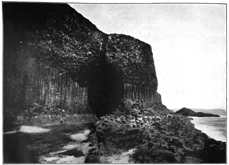
There are also other rocks in England, Scotland, Ireland, and almost every country in Europe, which we infer to be of igneous origin, although they do [446]not form hills with cones and craters. Thus, for example, we feel assured that the rock of Staffa and that of the Giant’s Causeway, called basalt, is volcanic, because it agrees in its columnar structure and mineral composition with streams of lava which we know to have flowed from the craters of volcanoes.
The absence of cones and craters, and long narrow streams of superficial lava in England and many other countries, is principally to be attributed to the eruptions having been submarine, just as a considerable proportion of volcanoes in our own times burst out beneath the sea. The igneous, as well as the aqueous rocks may be classed as a chronological series of monuments, throwing light on a succession of events in the history of the earth.
We have now pointed out the existence of two distinct orders of mineral masses, the aqueous and the volcanic; but if we examine a large portion of a continent, especially if it contain within it a lofty mountain range, we rarely fail to discover two other classes of rocks, very distinct from either of those above alluded to, and which we can neither assimilate to deposits such as are now accumulated in lakes or seas, nor to those generated by ordinary volcanic action. The members of both these divisions of rocks agree in being highly crystalline and destitute of organic remains. The rocks of one division have been called plutonic, comprehending all the granites and certain porphyries, which are nearly allied in some of their characters to volcanic formations. The members of the other class are stratified and often slaty, and have been called by some the crystalline schists, in which [447]group are included gneiss, micaceous-schist (or mica-slate), hornblende-schist, statuary marble, the finer kinds of roofing-slate, and other rocks afterward to be described.
All the various kinds of granites which constitute the plutonic family are supposed to be of igneous or aqueo-igneous origin, and to have been formed under great pressure, at a considerable depth in the earth, or sometimes perhaps under a certain weight of incumbent ocean. Like the lava of volcanoes, they have been melted, and afterward cooled and crystallized, but with extreme slowness, and under conditions very different from those of bodies cooling in the open air. Hence they differ from the volcanic rocks, not only by their more crystalline texture, but also by the absence of tuffs and breccias, which are the products of eruptions at the earth’s surface, or beneath seas of inconsiderable depth. They differ also by the absence of pores or cellular cavities, to which the expansion of the entangled gases gives rise in ordinary lava.
The fourth and last great division of rocks are the crystalline strata and slates, or schists, called gneiss, mica-schist, clay-slate, chlorite-schist, marble, and the like, the origin of which is more doubtful than that of the other three classes. They contain no pebbles, or sand, or scoriæ, or angular pieces of imbedded stone, and no traces of organic bodies, and they are often as crystalline as granite, yet are divided into beds, corresponding in form and arrangement to those of sedimentary formations, and are therefore said to be stratified. The beds sometimes [448]consist of an alternation of substances varying in color, composition, and thickness, precisely as we see in stratified fossiliferous deposits. According to the Huttonian theory, which I adopt as the most probable, the materials of these strata were originally deposited from water in the usual form of sediment, but they were subsequently so altered by subterranean heat as to assume a new texture. It is demonstrable, in some cases at least, that such a complete conversion has actually taken place, fossiliferous strata having exchanged an earthy for a highly crystalline texture for a distance of a quarter of a mile from their contact with granite. In some cases, dark limestones, replete with shells and corals, have been turned into white statuary marble, and hard clays, containing vegetable or other remains, into slates called mica-schist or hornblende-schist, every vestige of the organic bodies having been obliterated.
Although we are in a great degree ignorant of the precise nature of the influence exerted in these cases, yet it evidently bears some analogy to that which volcanic heat and gases are known to produce; and the action may be conveniently called plutonic, because it appears to have been developed in those regions where plutonic rocks are generated, and under similar circumstances of pressure and depth in the earth. Intensely heated water or steam permeating stratified masses under great pressure have no doubt played their part in producing the crystalline texture and other changes, and it is clear that the transforming influence has often pervaded entire mountain masses of strata.
[449]
In accordance with the hypothesis above alluded to, I proposed in the first edition of the Principles of Geology (1833), the term Metamorphic, for the altered strata, a term derived from meta, trans, and morphe, forma.
Hence there are four great classes of rocks considered in reference to their origin—the aqueous, the volcanic, the plutonic, and the metamorphic. Portions of each of these four distinct classes have originated at many successive periods. They have all been produced contemporaneously, and may even now be in the progress of formation on a large scale. It is not true, as was formerly supposed, that all granites, together with the crystalline or metamorphic strata, were first formed, and therefore entitled to be called “primitive,” and that the aqueous and volcanic rocks were afterward superimposed, and should, therefore, rank as secondary in the order of time. This idea was adopted in the infancy of the science, when all formations, whether stratified or unstratified, earthy or crystalline, with or without fossils, were alike regarded as of aqueous origin.
From what has now been said, the reader will understand that each of the four great classes of rocks may be studied under two distinct points of view; first, they may be studied simply as mineral masses deriving their origin from particular causes, and having a certain composition, form, and position in the earth’s crust, or other characters, both positive and negative, such as the presence or absence of organic remains. In the second place, the rocks of each class may be viewed as a grand chronological series of [450]monuments, attesting a succession of events in the former history of the globe and its living inhabitants.
The crust of the earth, as we somewhat modestly term that portion of its outer shell which is open to our observation, consists of many beds of rock superimposed on each other, and which must have been deposited successively, beginning with the lowest. This is proved by the structure of the beds themselves, by the markings on their surfaces, and by the remains of animals and plants which they contain; all these appearances indicating that each successive bed must have been the surface before it was covered by the next.
As these beds of rock were mostly formed under water, and of material derived from the waste of land, they are not universal, but occur in those places where there were extensive areas of water receiving detritus from the land. Further, as the distinction of land and water arises primarily from the shrinkage of the mass of the earth, and from the consequent collapse of the crust in some places and ridging of it up in others, it follows that there have, from the earliest geological periods, been deep ocean-basins, ridges of elevated land, and broad plateaus intervening between the ridges, and which were at some times under water and at other times land, with many intermediate phases. The settlement and crumpling of the crust were not continuous, but took place at [451]intervals; and each such settlement produced not only a ridging up along certain lines, but also an emergence of the plains or plateaus. Thus at all times there have been ridges of folded rock constituting mountain ranges, flat expansions of continental plateau, sometimes dry and sometimes submerged, and deep ocean-basins, never except in some of their shallower portions elevated into land.
By the study of the successive beds, more especially of those deposited in the times of continental submergence, we obtain a table of geological chronology which expresses the several stages of the formation of the earth’s crust, from that early time when a solid shell first formed on our nascent planet to the present day. By collecting the fossil remains imbedded in the several layers and placing these in chronological order, we obtain in like manner histories of animal and plant life parallel to the physical changes indicated by the beds themselves. The facts as to the sequence we obtain from the study of exposures in cliffs, cuttings, quarries, and mines; and by correlating these local sections in a great number of places, we obtain our general table of succession; though it is to be observed that in some single exposures or series of exposures, like those in the great cañons of Colorado, or on the coasts of Great Britain, we can often in one locality see nearly the whole sequence of beds.
The evidence is similar to that obtained by Schliemann on the site of Troy, where, in digging through successive layers of débris, he found the objects deposited by successive occupants of the site, from the [452]time of the Roman Empire back to the earliest tribes, whose flint weapons and the ashes of their fires rest on the original surface of the ground.
Let us now tabulate the whole geological succession with the history of animals and plants associated with it:
| ANIMALS | SYSTEMS OF FORMATIONS | PLANTS | |
|---|---|---|---|
| Age of Man and Mammalia | Kainozoic | ||
| Modern | Angiosperms and Palms dominant | ||
| Pleistocene | |||
| Pliocene | |||
| Miocene | |||
| Eocene | |||
| Age of Reptiles | Mesozoic | ||
| Cretaceous | Cycads and Pines dominant | ||
| Jurassic | |||
| Triassic | |||
| Age of Amphibians and Fishes | Palæozoic | ||
| Permian | Acrogens and Gymnosperms dominant | ||
| Carboniferous | |||
| Erian | |||
| Silurian | |||
| Age of Invertebrates | Ordovician | ||
| Cambrian | |||
| Huronian (Upper) | |||
| Age of Protozoa | Eozoic | ||
| Huronian (Lower) | Protogens and Algæ | ||
| Upper Laurentian | |||
| Middle Laurentian | |||
| Lower Laurentian | |||
It will be observed, since only the latest of the systems of formations in this table belongs to the period of human history, that the whole lapse of time embraced in the table must be enormous. If we suppose the modern period to have continued for say ten thousand years, and each of the others to have been equal to it, we shall require two hundred thousand [453]years for the whole. There is, however, reason to believe, from the great thickness of the formations and the slowness of the deposition of many of them in the older systems, that they must have required vastly greater time. Taking these criteria into account, it has been estimated that the time-ratios for the first three great ages may be as one for the Kainozoic to three for the Mesozoic and twelve for the Palæozoic, with as much for the Eozoic as for the Palæozoic. This is Dana’s estimate. Another, by Hull and Houghton, gives the following ratios: Azoic, 34.3 per cent; Palæozoic, 42.5 per cent; Mesozoic and Kainozoic, 23.3 per cent. It is further held that the modern period is much shorter than the other periods of the Kainozoic, so that our geological table may have to be measured by millions of years instead of thousands.
We can not, however, attach any certain and definite value in years to geological time, but must content ourselves with the general statement that it has been vastly long in comparison to that covered by human history.
Bearing in mind this great duration of geological time, and the fact that it probably extends from a period when the earth was intensely heated, its crust thin, and its continents as yet unformed, it will be evident that the conditions of life in the earlier geologic periods may have been very different from those which obtained later. When we further take into account the vicissitudes of land and water which have occurred, we shall see that such changes must have produced very great differences of climate. The [454]warm equatorial waters have in all periods, as superficial oceanic currents, been main agents in the diffusion of heat over the surface of the earth, and their distribution to north and south must have been determined mainly by the extent and direction of land, though it may also have been modified by the changes in the astronomical relations and period of the earth, and the form of its orbit. We know by the evidence of fossil plants that changes of this kind have occurred so great as, on the one hand, to permit the plants of warm temperate regions to exist within the Arctic Circle; and, on the other, to drive these plants into the tropics and to replace them by Arctic forms. It is evident also that in those periods when the continental areas were largely submerged there might be an excessive amount of moisture in the atmosphere, greatly modifying the climate in so far as plants are concerned.
Let us now consider the history of the vegetable kingdom as indicated in the few notes in the right-hand column of the table.
The most general subdivision of plants is into the two great series of Cryptogams, or those which have no manifest flowers, and produce minute spores instead of seeds; and Phænogams, or those which possess flowers and produce seeds containing an embryo of the future plant.
The Cryptogams may be subdivided into the following three groups:
1. Thallogens, cellular plants not distinctly distinguishable into stem and leaf. These are the Fungi, the Lichens, and the Algæ, or sea-weeds.
[455]
2. Anogens, having stem and foliage, but wholly cellular. These are the Mosses and Liverworts.
3. Acrogens, which have long tubular fibres as well as cells in their composition, and thus have the capacity of attaining a more considerable magnitude. These are the Ferns (Filices), the Mare’s-tails (Equisetaceæ), and the Club-mosses (Lycopodiaceæ), and a curious little group of aquatic plants called Rhizocarps (Rhizocarpeæ).
The Phænogams are all vascular, but they differ much in the simplicity or complexity of their flowers or seeds. On this ground they admit of a twofold division:
1. Gymnosperms, or those which bear naked seeds not inclosed in fruits. They are the Pines and their allies, and the Cycads.
2. Angiosperms, which produce true fruits inclosing the seeds. In this group there are two well-marked subdivisions differing in the structure of the seed and stem. They are the Endogens, or inside growers, with seeds having one seed-leaf only, as the grasses and the palms; and the Exogens, having outside-growing woody stems and seeds with two seed-leaves. Most of the ordinary forest trees of temperate climates belong to this group.
On referring to the geological table, it will be seen that there is a certain rough correspondence between the order of rank of plants and the order of their appearance in time. The oldest plants that we certainly know are Algæ, and with these there are plants apparently with the structures of Thallophytes but the habit of trees, and which, for want of a better name, [456]I may call Protogens. Plants akin to the Rhizocarps also appear very early. Next in order we find forests in which gigantic Ferns and Lycopods and Mare’s-tails predominate, and are associated with pines. Succeeding these we have a reign of Gymnosperms, and in the later formations we find the higher Phænogams dominant.
The crust of our earth is a great cemetery where the rocks are tombstones on which the buried dead have written their own epitaphs. They tell us not only who they were and when and where they have lived, but much also of the circumstances under which they lived. We ascertain the prevalence of certain physical conditions at special epochs by the presence of animals and plants whose existence and maintenance requires such a state of things, more than by any positive knowledge respecting it. Where we find the remains of quadrupeds corresponding to our ruminating animals, we infer not only land, but grassy meadows and an extensive vegetation; where we find none but marine animals, we know the ocean must have covered the earth; the remains of large reptiles, representing, though in gigantic size, the half aquatic, half terrestrial reptiles of our own period, indicate to us the existence of spreading marshes still soaked by retreating waters; while the traces of such animals as live now in sand and shoal waters, or in mud, speak to us of shelving sandy [457]beaches and mud flats. The eye of the Trilobite tells us that the sun shone on the old beach where he lived; for there is nothing in nature without a purpose, and when so complicated an organ was made to receive the light there must have been light to enter it. The immense vegetable deposits in the Carboniferous period announce the introduction of an extensive terrestrial vegetation; and the impressions left by the wood and leaves show that these first forests must have grown in a damp soil and a moist atmosphere. In short, all the remains of animals and plants hidden in the rocks have something to tell of the climatic conditions and the general circumstances under which they lived, and the study of fossils is to a naturalist a thermometer by which he reads the variation of temperature in past times, a plummet by which he sounds the depths of the ancient oceans—a register, in fact, of all the important physical changes the earth has undergone.
The Silurian beach was a shelving one, and covered, of course, with shoal waters; but the parallel ridges trending east to west across the State of New York, considered by some geologists as the successive shores of a receding ocean, are believed by others to be the inequalities on the bottom of a shallow sea. Not only, however, does the general character of these successive terraces suggest the idea that they must have been shores, but the ripple marks upon them are as distinct as upon any modern beach. The regular rise and fall of the water is registered there in waving, undulating lines as clearly as on the sand beaches of Newport or Nahant; and we can see on [458]any of those ancient shores the track left by the waves as they rippled back at ebb of the tide thousands of centuries ago. One can often see where some obstacle interrupted the course of the water, causing it to break around it; and such an indentation even retains the soft, muddy, plastic look that we observe on the present beaches, where the resistance made by any pebble or shell to the retreating wave has given it greater force at that point, so that the sand around the spot is soaked and loosened. There is still another sign familiar to those who have watched the action of water on a beach. Where a shore is very shelving and flat, so that the waves do not recede in ripples from it, but in one unbroken sheet, the sand and small pebbles are dragged and form lines which diverge whenever the water meets an obstacle, thus forming sharp angles on the sand. Such marks are as distinct on the oldest Silurian rocks as if they had been made yesterday. Nor are these the only indications of the same fact. There are certain animals living always on sandy or muddy shores which require for their well-being that the beach should be left dry for a part of the day. These animals, moving about in the sand or mud from which the water has retreated, leave their tracks there; and if, at such a time, the wind is blowing dust over the beach and the sun is hot enough to bake it upon the impressions so formed, they are left in a kind of mold. Such trails and furrows made by small shells and crustacea are also found in plenty on the oldest deposits.
Admitting it, then, to be a beach, let us begin with the lowest type of the Animal Kingdom and see [459]what Radiates are to be found there. There are plenty of Corals, but they are not the same kind of Corals as those that build up our reefs and islands now. The modern Coral animals are chiefly Polyps, but the prevailing Corals of the Silurian age were Acalephian Hydroids, animals which indeed resemble Polyps in certain external features, and have been mistaken for them, but which are, nevertheless, Acalephs by their internal structure.
Of the Echinoderms, the class of Radiates represented now by our Star-Fishes and Sea-Urchins, we may gather any quantity, though the old-fashioned forms are very different from the living ones. The Mollusks were also represented then, as now, by their three classes, Acephala, Gasteropoda, and Cephalopoda. The Acephala or Bivalves we find in great numbers, but of a very different pattern from the Oysters, Clams, and Mussels of recent times.
Of the Silurian Univalves or Gasteropods, there is not much to tell, for their spiral shells were so brittle that scarcely any perfect specimens are known, though their broken remains are found in such quantities as to show that this class also was very fully represented in the earliest creation. But the highest class of Mollusks, the Cephalopods or Chambered Shells, or Cuttle-Fishes, as they are called when the animal is unprotected by a shell, are, on the contrary, very well preserved, and they are very numerous.
Of Articulates we find only two classes, Worms and Crustacea. Insects there were none—for, as we have seen, this early world was wholly marine. There is little to be said of the Worms, for their soft [460]bodies, unprotected by any hard covering, could hardly be preserved; but, like the marine Worms of our own times, they were in the habit of constructing envelopes for themselves, built of sand, or sometimes from a secretion of their own bodies, and these cases we find in the earliest deposits, giving us the assurance that the Worms were represented there. I should add, however, that many impressions described as produced by Worms are more likely to have been the tracks of Crustacea. But by far the most characteristic class of Articulates in ancient times were the Crustaceans. The Trilobites stand in the same relation to the modern Crustacea as the Crinoids do to the modern Echinoderms. They were then the sole representatives of their class, and the variety and richness of the type are most extraordinary. They were of nearly equal breadth for the whole length of the body, and rounded at the two ends, so as to form an oval outline.
We have found Radiates, Mollusks, and Articulates in plenty; and now what is to be said of Vertebrates in these old times—of the highest and most important division of the Animal Kingdom, that to which we ourselves belong. They were represented by Fishes alone; and the fish chapter in the history of the early organic world is a curious and, as it seems to me, a very significant one. We shall find no perfect specimens; and he would be a daring, not to say a presumptuous, thinker who would venture to reconstruct a fish of the Silurian age from any remains that are left to us. But still we find enough to indicate clearly the style of those old fishes, [461]and to show, by comparison with the living types, to what group of modern times they belong. We should naturally expect to find the Vertebrates introduced in their simplest form; but this is by no means the case: the common fishes, as Cod, Herring, Mackerel, and the like, were unknown in those days.
I have spoken of the Silurian beach as if there were but one, not only because I wished to limit my sketch and to attempt, at least, to give it the vividness of a special locality, but also because a single such shore will give us as good an idea of the characteristic fauna of the time as if we drew our material from a wider range. There are, however, a great number of parallel ridges belonging to the Silurian and Devonian periods running from east to west, not only through the State of New York, but far beyond, through the States of Michigan and Wisconsin into Minnesota; one may follow nine or ten such successive shores in unbroken lines from the neighborhood of Lake Champlain to the Far West.
Although the early geological periods are more legible in North America, because they are exposed over such extensive tracts of land, yet they have been studied in many parts of the globe. In Norway, in Germany, in France, in Russia, in Siberia, in Kamtchatka, in parts of South America, in short, wherever the civilization of the white race has extended, Silurian deposits have been observed, and everywhere they bear the same testimony to a profuse and varied creation. The earth was teeming then with life as now, and in whatever corner of its surface the geologist finds the old strata, they hold [462]a dead fauna as numerous as that which lives and moves above it. Nor do we find that there was any gradual increase or decrease of any organic forms at the beginning or close of the successive periods.
I think the impression that the faunæ of the early geological periods were more scanty than those of later times arises partly from the fact that the present creation is made a standard of comparison for all preceding creations. Of course, the collection of living types in any museum must be more numerous than those of fossil forms, for the simple reason that almost the whole of the present surface of the earth, with the animals and plants inhabiting it, is known to us, whereas the deposits of the Silurian and Devonian periods are exposed to view only over comparatively limited tracts and in disconnected regions. But let us compare a given extent of Silurian or Devonian seashore with an equal extent of seashore belonging to our own time, and we shall soon be convinced that the one is as populous as the other. On the New England Coast there are about one hundred and fifty different kinds of fishes; in the Gulf of Mexico two hundred and fifty; in the Red Sea about the same. We may allow in present times an average of two hundred or two hundred and fifty different kinds of fishes to an extent of ocean covering about four hundred miles. Now, I have made a special study of the Devonian rocks of Northern Europe, in the Baltic, and along the shore of the German Ocean. I have found in those deposits alone one hundred and ten kinds of fossil fishes. To judge of the total number of species belonging to those early [463]ages by the number known to exist now is about as reasonable as to infer that because Aristotle, familiar only with the waters of Greece, recorded less than three hundred kinds of fishes in his limited fishing-ground, therefore these were all the fishes then living. The fishing-ground of the geologist in the Silurian and Devonian periods is even more circumscribed than his, and belongs, besides, not to a living but to a dead world, far more difficult to decipher.
Extinct animals exist all over the world; heaped together under the snows of Siberia, lying thick beneath the Indian soil, found wherever English settlers till the ground or work the mines in Australia, figured in the old encyclopedias of China, where the Chinese philosophers have drawn them with the accuracy of their nation, built into the most beautiful temples of classic lands—for even the stones of the Parthenon are full of the fragments of these old fossils, and if any chance had directed the attention of Aristotle toward them, the science of Paleontology would not have waited for its founder till Cuvier was born—in short, in every corner of the earth where the investigations of civilized men have penetrated, from the Arctic to Patagonia and the Cape of Good Hope, these relics tell us of successive populations lying far behind our own, and belonging to distinct periods of the world’s history.
[464]
In the history of our globe the Carboniferous period succeeds to the Devonian. It is in the formations of this latter epoch that we find the fossil fuel which has done so much to enrich and civilize the world in our own age. This period divides itself into two great sub-periods: 1. The Coal-measures; and 2. The Carboniferous Limestone. The first, a period which gave rise to the great deposits of coal; the second, to most important marine deposits, most frequently underlying the coal-fields in England, Belgium, France, and America.
The limestone mountains, which form the base of the whole system, attain in places, according to Professor Phillips, a thickness of 2,500 feet. They are of marine origin, as is apparent by the multitude of fossils they contain of Zoophytes, Radiata, Cephalopoda, and Fishes. But the chief characteristic of this epoch is its strictly terrestrial flora—remains of plants now become as common as they were rare in all previous formations, announcing a great increase of dry land.
The monuments of this era of profuse vegetation reveal themselves in the precious Coal-measures of England and Scotland. These give us some idea of the rich verdure which covered the surface of the earth, newly risen from the bosom of its parent waves. It was the paradise of terrestrial vegetation. The grand Sigillaria, the Stigmaria, and other fern-like [465]plants, were especially typical of this age, and formed the woods, which were left to grow undisturbed; for as yet no living Mammals seem to have appeared; everything indicates a uniformly warm, humid temperature, the only climate in which the gigantic ferns of the Coal-measures could have attained their magnitude. Conifers have been found of this period with concentric rings, but these rings are more slightly marked than in existing trees of the same family, from which it is reasonable to assume that the seasonal changes were less marked than they are with us.
Everything announces that the time occupied in the deposition of the Carboniferous Limestone was one of vast duration. Professor Phillips calculates that, at the ordinary rate of progress, it would require 122,400 years to produce only sixty feet of coal. Geologists believe, moreover, that the upper Coal-measures, where bed has been deposited upon bed for ages upon ages, were accumulated under conditions of comparative tranquillity, but that the end of this period was marked by violent convulsions—by ruptures of the terrestrial crust, when the carboniferous rocks were upturned, contorted, dislocated by faults, and subsequently partially denuded, and thus appear now in depressions or basin-shaped concavities; and that upon this deranged and disturbed foundation a fourth geological system, called Permian, was constructed.
Coal, as we shall find, is composed of the mineralized remains of the vegetation which flourished in remote ages of the world. Buried under an enormous [466]thickness of rocks, it has been preserved to our days, after being modified in its inward nature and external aspect. Having lost a portion of its elementary constituents, it has become transformed into a species of carbon, impregnated with those bituminous substances which are the ordinary products of the slow decomposition of vegetable matter.
Thus, coal is the substance of the plants which formed the forests, the vegetation, and the marshes of the ancient world, at a period too distant for human chronology to calculate with anything like precision.
It is a remarkable circumstance that conditions of equable and warm climate, combined with humidity, do not seem to have been limited to any one part of the globe, but the temperature of the whole globe seems to have been nearly the same in very different latitudes. From the equatorial regions up to Melville Island, in the Arctic Ocean, where in our days eternal frost prevails—from Spitzbergen to the centre of Africa, the carboniferous flora is identically the same. When nearly the same plants are found in Greenland and Guinea; when the same species, now extinct, are met with of equal development at the equator as at the pole, we can not but admit that at this epoch the temperature of the globe was nearly alike everywhere. What we now call climate was unknown in these geological times. There seems to have been then only one climate over the whole globe. It was at a subsequent period, that is, in later Tertiary times, that the cold began to make itself felt at the terrestrial poles. Whence, then, proceeded this general superficial [467]warmth, which we now regard with so much surprise? It was a consequence of the greater or nearer influence of the interior heat of the globe. The earth was still so hot in itself that the heat which reached it from the sun may have been inappreciable.
Another hypothesis, which has been advanced with much less certainty than the preceding, relates to the chemical composition of the air during the Carboniferous period. Seeing the enormous mass of vegetation which then covered the globe, and extended from one pole to the other; considering, also, the great proportion of carbon and hydrogen which exists in the bituminous matter of coal, it has been thought, and not without reason, that the atmosphere of the period might be richer in carbonic acid than the atmosphere of the present day. It has even been thought that the small number of (especially air-breathing) animals, which then lived, might be accounted for by the presence of a greater proportion of carbonic acid gas in the atmosphere than is the case in our own times. This, however, is pure assumption, totally deficient in proof. What we can remark, with certainty, as a striking characteristic of the vegetation of the globe during this phase of its history, was the prodigious development which it assumed. The Ferns, which in our days and in our climate are most commonly only small perennial plants, in the Carboniferous age sometimes presented themselves under lofty and even magnificent forms.
Every one knows those marsh-plants with hollow, channeled, and articulated cylindrical stems; whose joints are furnished with a membranous, denticulated [468]sheath, and which bear the vulgar name of “mare’s-tail”; their fructification forming a sort of catkin composed of many rings of scales, carrying on their lower surface sacs full of spores or seeds. These humble Equiseta were represented during the coal-period by herbaceous trees from twenty to thirty feet high and four to six inches in diameter. Their trunks, channeled longitudinally, and divided transversely by lines of articulation, have been preserved to us: they bear the name of Calamites.
The Lycopods of our age are humble plants, scarcely a yard in height, and most commonly creepers; but the Lycopodiaceæ of the ancient world were trees of eighty or ninety feet in height. It was the Lepidodendrons which filled the forests. Their leaves were sometimes twenty inches long, and their trunks a yard in diameter. Such are the dimensions of some specimens of Lepidodendron carinatum which have been found. Another Lycopod of this period, the Lomatophloyos crassicaule, attained dimensions still more colossal. The Sigillarias sometimes exceeded 100 feet in height. Herbaceous Ferns were also exceedingly abundant, and grew beneath the shade of these gigantic trees. It was the combination of these lofty trees with such shrubs (if we may so call them) which formed the forests of the Carboniferous period.
How this vegetation, so imposing, both on account of the dimensions of the individual trees and the immense space which they occupied, so splendid in its aspect, and yet so simple in its organization, must have differed from that which now embellishes the [469]earth and charms our eyes! It certainly possessed the advantage of size and rapid growth; but how poor it was in species—how uniform in appearance! No flowers yet adorned the foliage or varied the tints of the forests. Eternal verdure clothed the branches of the Ferns, the Lycopods, and Equiseta, which composed to a great extent the vegetation of the age. The forests presented an innumerable collection of individuals, but very few species, and all belonging to the lower types of vegetation. No fruit appeared fit for nourishment; none would seem to have been on the branches. Suffice it to say that few terrestrial animals seem to have existed yet; animal life was apparently almost wholly confined to the sea, while the vegetable kingdom occupied the land, which at a later period was more thickly inhabited by air-breathing animals. Probably a few winged insects (some coleoptera, orthoptera, and neuroptera) gave animation to the air while exhibiting their variegated colors; and it was not impossible but that many pulmoniferous mollusca (such as land-snails) lived at the same time.
The vegetation which covered the numerous islands of the Carboniferous sea consisted, then, of Ferns, of Equisetaceæ, of Lycopodiaceæ, and dicotyledonous Gymnosperms. The Annularia and Sigillariæ belong to families of the last-named class, which are now completely extinct.
The Annulariæ were small plants which floated on the surface of fresh-water lakes and ponds; their leaves were verticillate, that is, arranged in a great number of whorls, at each articulation of the stem [470]with the branches. The Sigillariæ were, on the contrary, great trees, consisting of a simple trunk, surmounted with a bunch or panicle of slender drooping leaves, with the bark often channeled, and displaying impressions or scars of the old leaves, which, from their resemblance to a seal, sigillum, gave origin to their name.
The Stigmariæ, according to palæontologists, were roots of Sigillariæ, with a subterranean fructification; all that is known of them is the long roots which carry the reproductive organs, and in some cases are as much as sixteen feet long.
Two other gigantic trees grew in the forests of this period: these were Lepidodendron carinatum and Lomatophloyos crassicaule, both belonging to the family of Lycopodiaceæ, which now includes only very small species. The trunk of the Lomatophloyos threw out numerous branches, which terminated in thick tufts of linear and fleshy leaves. The Ferns composed a great part of the vegetation of the Coal-measure period.
The seas of this epoch included an immense number of Zoophytes, nearly 400 species of Mollusca, and a few Crustaceans and Fishes. Among the Fishes, Psammodus and Coccosteus, whose massive teeth inserted in the palate were suitable for grinding; and the Holoptychius and Megalichthys, are the most important. The Mollusca are chiefly Brachiopods of great size. The Bellerophon, whose convoluted shell in some respects resembles the Nautilus of our present seas, but without its chambered shell, were then represented by many species.
[471]
Crustaceans are rare in the Carboniferous Limestone strata; the genus Phillipsia is the last of the Trilobites, all of which became extinct at the close of this period. As to the Zoophytes, they consist chiefly of Crinoids and Corals. We also have in these rocks many Polyzoa.
Among the corals of the period we may include the genera Lithostrotion and Lonsdalea. Among the Polyzoa are the genera Fenestrella and Polypora. Lastly, to these we may add a group of animals which will play a very important part and become abundantly represented in the beds of later geological periods, but which already abounded in the seas of the Carboniferous period. We speak of the Foraminifera, microscopic animals, which clustered either in one body or divided into segments, and covered with a calcareous, many-chambered shell, as Fusulina cylindrica. These little creatures, which, during the Jurassic and Cretaceous periods, formed enormous banks and entire masses of rock, began to make their appearance in the period which now engages our attention.
This terrestrial period is characterized, in a remarkable manner, by the abundance and strangeness of the vegetation which then covered the islands and continents of the whole globe. Upon all points of the earth, as we have said, this flora presented a striking uniformity. In comparing it with the vegetation of the present day, the learned French botanist, M. Brongniart, who has given particular attention to the flora of the Coal-measures, has arrived at the conclusion that it presented considerable analogy with [472]that of the islands of the equatorial and torrid zone, in which a maritime climate and elevated temperature exist in the highest degree. It is believed that islands were very numerous at this period; that, in short, the dry land formed a sort of vast archipelago upon the general ocean, of no great depth, the islands being connected together and formed into continents as they gradually emerged from the ocean.
This flora, then, consists of great trees, and also of many smaller plants, which would form a close, thick turf, or sod, when partially buried in marshes of almost unlimited extent. M. Brongniart indicates, as characterizing the period, 500 species of plants which now attain a prodigious development. The ordinary dicotyledons and monocotyledons—that is, plants having seeds with two lobes in germinating and plants having one seed-lobe—are almost entirely absent; the cryptogamic, or flowerless plants, predominate; especially Ferns, Lycopodiaceæ, and Equisetaceæ—but of forms insulated and actually extinct in these same families. A few dicotyledonous gymnosperms, or naked-seed plants forming genera of Conifers, have completely disappeared, not only from the present flora, but since the close of the period under consideration, there being no trace of them in the succeeding Permian flora. Such is a general view of the features most characteristic of the coal-period, and of the Primary epoch in general. It differs, altogether and absolutely, from that of the present day; the climatic condition of these remote ages of the globe, however, enables us to comprehend the characteristics which distinguish its vegetation. [473]A damp atmosphere, of an equable rather than an intense heat like that of the tropics, a soft light veiled by permanent fogs, were favorable to the growth of this peculiar vegetation, of which we search in vain for anything strictly analogous in our own days. The nearest approach to the climate and vegetation proper to the geological period which now occupies our attention would probably be found in certain islands, or on the littoral of the Pacific Ocean—the island of Chloë, for example, where it rains during 300 days in the year, and where the light of the sun is shut out by perpetual fogs; where arborescent Ferns form forests, beneath whose shade grow herbaceous Ferns, which rise three feet and upward above a marshy soil; which gives shelter also to a mass of cryptogamic plants, greatly resembling, in its main features, the flora of the Coal-measures. This flora was, as we have said, uniform and poor in its botanic genera, compared to the abundance and variety of the flora of the present time; but the few families of plants which existed then included many more species than are now produced in the same countries. The fossil Ferns of the coal-series in Europe, for instance, comprehend about 300 species, while all Europe now only produces fifty. The gymnosperms, which now muster only twenty-five species in Europe, then numbered more than 120.
Calamites are among the most abundant fossil plants of the Carboniferous period, and occur also in the Devonian. They are preserved as striated, jointed, cylindrical, or compressed stems, with fluted channels or furrows at their sides, and sometimes [474]surrounded by a bituminous coating, the remains of a cortical integument. They were originally hollow, but the cavity is usually filled up with a substance into which they themselves have been converted.
If, during the coal-period, the vegetable kingdom had reached its maximum, the animal kingdom, on the contrary, was poorly represented. Some remains have been found, both in America and Germany, consisting of portions of the skeleton and the impressions of the footsteps of a Reptile, which has received the name of Archegosaurus. Among the animals of this period we find a few Fishes, analogous to those of the Devonian formation. These are the Holoptychius and Megalichthys, having jawbones armed with enormous teeth. Scales of Pygopterus have been found in the Northumberland Coal-shale at Newsham Colliery, and also in the Staffordshire Coal-shale. Some winged insects would probably join this slender group of living beings. It may then be said with truth that the immense forests and marshy plains, crowded with trees, shrubs, and herbaceous plants, which formed on the innumerable isles of the period a thick and tufted sward, were almost destitute of animals.
Coal, as we have said, is only the result of a partial decomposition of the plants which covered the earth during a geological period of immense duration. No one, now, has any doubt that this is its origin. In coal-mines it is not unusual to find fragments of the very plants whose trunks and leaves characterize the Coal-measures, or Carboniferous era. Immense trunks of trees have also been met [475]with in the middle of a seam of coal. In order to explain the presence of coal in the depths of the earth, there are only two possible hypotheses. This vegetable débris may either result from the burying of plants brought from afar and transported by river or maritime currents, forming immense rafts, which may have grounded in different places and been covered subsequently by sedimentary deposits; or the trees may have grown on the spot where they perished, and where they are now found.
Can the coal-beds result from the transport by water, and burial under ground, of immense rafts formed of the trunks of trees? The hypothesis has against it the enormous height which must be conceded to the raft, in order to form coal-seams as thick as some of those which are worked in our collieries. If we take into consideration the specific gravity of wood, and the amount of carbon it contains, we find that the coal-deposits can only be about seven-hundredths of the volume of the original wood and other vegetable materials from which they are formed. If we take into account, besides, the numerous voids necessarily arising from the loose packing of the materials forming the supposed raft, as compared with the compactness of coal, this may fairly be reduced to five-hundredths. A bed of coal, for instance, sixteen feet thick, would have required a raft 310 feet high for its formation. These accumulations of wood could never have arranged themselves with sufficient regularity to form those well-stratified coal-beds, maintaining a uniform thickness [476]over many miles, and that are seen in most coal-fields to lie one above another in succession, separated by beds of sandstone or shale. And even admitting the possibility of a slow and gradual accumulation of vegetable débris, like that which reaches the mouth of a river, would not the plants in that case be buried in great quantities of mud and earth? Now, in most of our coal-beds the proportion of earthy matter does not exceed fifteen per cent of the entire mass. If we bear in mind, finally, the remarkable parallelism existing in the stratification of the coal-formation, and the state of preservation in which the impressions of the most delicate vegetable forms are discovered, it will, we think, be proved to demonstration that those coal-seams have been formed in perfect tranquillity. We are, then, forced to the conclusion that coal results from the mineralization of plants which has taken place on the spot; that is to say, in the very place where the plants lived and died.
It was suggested long ago by Bakewell, from the occurrence of the same peculiar kind of fireclay under each bed of coal, that it was the soil proper for the production of those plants from which coal has been formed.
The clay-beds, “which vary in thickness from a few inches to more than ten feet, are penetrated in all directions by a confused and tangled collection of the roots and leaves, as they may be, of the Stigmaria ficoides, these being frequently traceable to the main stem (Sigillaria), which varies in diameter from about two inches to half a foot. The main stems are noticed as occurring nearer the top than the bottom [477]of the bed, as usually of considerable length, the leaves or roots radiating from them in a tortuous irregular course to considerable distances, and as so mingled with the under-clay that it is not possible to cut out a cubic foot of it which does not contain portions of the plant.”
It is a natural inference to suppose that the present indurated under-clay is only another condition of that soft, silty soil, or of that finely levigated muddy sediment—most likely of still and shallow water—in which the vegetation grew, the remains of which were afterward carbonized and converted into coal.
In order thoroughly to comprehend the phenomena of the transformation into coal of the forests and of the herbaceous plants which filled the marshes and swamps of the ancient world, there is another consideration to be presented. During the coal-period, the terrestrial crust was subjected to alternate movements of elevation and depression of the internal liquid mass, under the impulse of the solar and lunar attractions to which they would be subject, as our seas are now, giving rise to a sort of subterranean tide, operating at intervals, more or less widely apart, upon the weaker parts of the crust, and producing considerable subsidences of the ground. It might, perhaps, happen that, in consequence of a subsidence produced in such a manner, the vegetation of the coal-period would be submerged, and the shrubs and plants which covered the surface of the earth would finally become buried under water. After this submergence new forests sprung up in the same place. Owing to another submergence, the second [478]forests were depressed in their turn, and again covered by water. It is probably by a series of repetitions of this double phenomenon—this submergence of whole regions of forest, and the development upon the same site of new growths of vegetation—that the enormous accumulations of semi-decomposed plants, which constitute the Coal-measures, have been formed in a long series of ages.
But, has coal been produced from the larger plants only—for example, from the great forest-trees of the period, such as the Lepidodendra, Sigillariæ, Calamites, and Sphenophylla? That is scarcely probable, for many coal-deposits contain no vestiges of the great trees of the period, but only of Ferns and other herbaceous plants of small size. It is, therefore, presumable that the larger vegetation has been almost unconnected with the formation of coal, or, at least, that it has played a minor part in its production. In all probability there existed in the coal-period, as at the present time, two distinct kinds of vegetation: one formed of lofty forest-trees, growing on the higher grounds; the other, herbaceous and aquatic plants, growing on marshy plains. It is the latter kind of vegetation, probably, which has mostly furnished the material for the coal; in the same way that marsh-plants have, during historic times and up to the present day, supplied our existing peat, which may be regarded as a sort of contemporaneous incipient coal.
To what modification has the vegetation of the ancient world been subjected to attain that carbonized state which constitutes coal? The submerged plants [479]would, at first, be a light, spongy mass, in all respects resembling the peat-moss of our moors and marshes. While under water, and afterward, when covered with sediment, these vegetable masses underwent a partial decomposition—a moist, putrefactive fermentation, accompanied by the production of much carbureted hydrogen and carbonic acid gas. In this way, the hydrogen escaping in the form of carbureted hydrogen, and the oxygen in the form of carbonic acid gas, the carbon became more concentrated, and coal was ultimately formed. This emission of carbureted hydrogen gas would, probably, continue after the peat-beds were buried beneath the strata which were deposited and accumulated upon them. The mere weight and pressure of the superincumbent mass, continued at an increasing ratio during a long series of ages, have given to the coal its density and compact state.
The heat emanating from the interior of the globe would also exercise a great influence upon the final result. It is to these two causes—that is to say, to pressure and to the central heat—that we may attribute the differences which exist in the mineral characters of various kinds of coal. The inferior beds are drier and more compact than the upper ones; or less bituminous, because their mineralization has been completed under the influence of a higher temperature, and at the same time under a greater pressure.
[480]
However much the faunas of the various geologic periods may have differed from each other, or from the fauna which now exists, in their general aspect and character, they were all, if I may so speak, equally underlaid by the great leading ideas which still constitute the master types of animal life. And these leading ideas are four in number. First, there is the star-like type of life—life embodied in a form that, as in the corals, the sea-anemones, the sea-urchins, and the star-fishes, radiates outward from a centre; second, there is the articulated type of life—life embodied in a form composed, as in the worms, crustaceans, and insects, of a series of rings united by their edges, but more or less movable on each other; third, there is the bilateral or molluscan type of life—life embodied in a form in which there is a duality of corresponding parts, ranged, as in the cuttle-fishes, the clams, and the snails, on the sides of a central axis or plane; and fourth, there is the vertebrate type of life—life embodied in a form in which an internal skeleton is built up into two cavities placed the one over the other; the upper for the reception of the nervous centres, cerebral and spinal—the lower for the lodgment of the respiratory, circulatory, and digestive organs. Such have been the four central ideas of the faunas of every succeeding creation, except, perhaps, the earliest of all, that of the Lower Silurian System, [481]in which, so far as is yet known, only three of the number existed—the radiated, articulated, and molluscan ideas or types.
The fauna of the Silurian System bears in all its three great types the stamp of a fashion peculiarly antique, and which, save in a few of the mollusca, has long since become obsolete. Its radiate animals are chiefly corals, simple or compound, whose inhabitants may have somewhat resembled the sea-anemones; with zoophytes, akin mayhap to the sea-pens, though the relationship must have been a remote one; and numerous crinoids, or stone lilies, some of which consisted of but a sculptured calyx without petals, while others threw off a series of long flexible arms, that divided and subdivided like the branches of a tree, and were thickly fringed by hair-like fibres.
The articulata of the Silurian period bore a still more peculiar character. They consisted mainly of the Trilobites—a family in whose nicely jointed shells the armorer of the Middle Ages might have found almost all the contrivances of his craft anticipated, with not a few besides which he had failed to discover; and which, after receiving so immense a development during the middle and later times of the Silurian period that whole rocks were formed almost exclusively of their remains, gradually died out in the times of the Old Red Sandstone, and disappeared forever from creation after the Carboniferous Limestone had been deposited. The mollusca of the Silurians ranged from the high cephalopoda, represented in our existing seas by the nautili and the [482]cuttle-fishes, to the low brachiopods, some of whose cogeners may still be detected in the terebratulæ of the Highland lochs and bays, and some in the lingulæ of the Southern Hemisphere. The cephalopods of the system are all of an obsolete type, that disappeared myriads of ages ago. At length, in an upper bed of the system, immediately under the base of the Old Red Sandstone, the remains of the earliest known fishes appear, blended with what also appears for the first time—the fragmentary remains of a terrestrial vegetation. The rocks beneath this ancient bone-bed have yielded no trace of any plant higher than the Thallogens, or at least not higher than the Zosteraceæ—plants whose proper habitat is the sea; but, through an apparently simultaneous advance of the two kingdoms, animal and vegetable—though, of course, the simultaneousness may be but merely apparent—the first land-plants and the first vertebrates appear together in the same deposit. The earliest fishes—first-born of their family—seem to have been all placoids. The Silurian System has not yet afforded trace of any other vertebral animal. With the Old Red Sandstone the ganoids were ushered upon the scene in amazing abundance; and for untold ages, comprising mayhap millions of years, the entire ichthyic class consisted, so far as is yet known, of but these two orders. During the times of the Old Red Sandstone, of the Carboniferous, of the Permian, of the Triassic, and of the Oolitic Systems, all fishes, though apparently as numerous individually as they are now, were comprised in the ganoidal and placoidal orders. The period [483]of these orders seems to have been nearly correspondent with the reign, in the vegetable kingdom, of the Acrogens and Gymnogens, with the intermediate classes, their allies. At length, during the ages of the Chalk, the Cycloids and Ctenoids were ushered in, and were gradually developed in creation until the human period, in which they seem to have reached their culminating point, and now many times exceed in number and importance all other fishes. The delicate Salmonidæ and the Pleuronectidæ—families to which the salmon and turbot belong—were ushered into being as early as the times of the Chalk; but the Gadidæ or cod family—that family to which the cod proper, the haddock, the dorse, the whiting, the coal-fish, the pollock, the hake, the torsk, and the ling belong, with many other useful and wholesome species—did not precede man by at least any period of time appreciable to the geologist. No trace of the family has yet been detected in even the Tertiary rocks.
Of the ganoids of the second age of vertebrate existence—that of the Old Red Sandstone—some were remarkable for the strangeness of their forms, and some for constituting links of connection, which no longer exist in nature, between the ganoid and placoid orders. The Acanth family, which ceased with the Coal-measures, was characterized, especially in its Old Red species, by a combination of traits common to both orders; and among the extremer forms, in which palæontologists for a time failed to detect that of the fish at all, we reckon those of the genera Coccosteus, Pterichthys, and Cephalaspis. The more [484]aberrant genera, however, even while they consisted each of several species, were comparatively short-lived. The Coccosteus and Cephalaspis were restricted to but one formation apiece; while the Pterichthys, which appears for the first time in the lower deposits of the Old Red Sandstone, becomes extinct at its close. On the other hand, some of the genera that exemplified the general type of their class were extremely long-lived. The Celacanths were reproduced in many various species, from the times of the Lower Old Red Sandstone to those of the Chalk; and the Cestracions, which appear in the Upper Ludlow Rocks as the oldest of fishes, continue in at least one species to exist still.
The ancient fishes seem to have received their fullest development during the Carboniferous period. Their number was very great: some of them attained to an enormous size, and, though the true reptile had already appeared, they continued to retain till the close of the System the high reptilian character and organization. Nothing, however, so impresses the observer as the formidable character of the offensive weapons with which they were furnished, and the amazing strength of their defensive armature. I need scarce say that the palæontologist finds no trace in nature of that golden age of the world, of which the poets delighted to sing, when all creatures lived together in unbroken peace, and war and bloodshed were unknown. Ever since animal life began upon our planet there existed, in all the departments of being, carnivorous classes, who could not live but by the death of their neighbors, and [485]who were armed, in consequence, for their destruction, like the butcher with his axe and knife, and the angler with his hook and spear. But there were certain periods in the history of the past during which these weapons assumed a more formidable aspect than at others; and never were they more formidable than in the times of the Coal-measures. The teeth of the Rhizodus—a ganoidal fish of our coal-fields—were more sharp and trenchant than those of the crocodile of the Nile, and in the larger specimens fully four times the bulk and size of the teeth of the hugest reptile of this species that now lives. The dorsal spine of its contemporary, the Gyracanthus, a great placoid, much exceeded in size that of any existing fish; it was a mighty spearhead, ornately carved like that of a New Zealand chief, but in a style that, when he first saw a specimen in my collection, greatly excited the admiration of Mr. Ruskin. But one of the most remarkable weapons of the period was the sting of the Pleuracanthus, another great placoid of the age of gigantic fishes. It was sharp and polished as a stiletto, but, from its rounded form and dense structure, of great strength; and along two of its sides, from the taper point to within a few inches of the base, there ran a thickly set row of barbs, hooked downward, like the thorns that bristle on the young shoots of the wild rose, and which must have rendered it a weapon not merely of destruction, but also of torture. The defensive armor of the period, especially that of its ganoids, seems to have been as remarkable for its powers of resistance as the offensive must have been [486]for their potency in the assault; and it seems probable that in the great strength of the bony and enameled armature of this order of fishes we have the secret of the extremely formidable character of the teeth, spines, and stings that coexisted along with it.
The oldest known reptiles appear just a little before the close of the Old Red Sandstone, just as the oldest known fishes appeared just a little before the close of the Silurian System. What seems to be the Upper Old Red of Great Britain, though there still hangs a shade of doubt on the subject, has furnished the remains of a small reptile, equally akin, it would appear, to the lizards and the batrachians; and what seems to be the Upper Old Red of the United States has exhibited the foot-tracks of a larger animal of the same class, which not a little resemble those which would be impressed on recent sand or clay by the alligator of the Mississippi, did not the alligator of the Mississippi efface its own footprints (a consequence of the shortness of its legs) by the trail of its abdomen. In the Coal-measures the reptiles hitherto found are all allied, though not without a cross of the higher crocodilian or lacertian nature, to the batrachian order—that lowest order of the reptiles to which the frogs, newts, and salamanders belong. It was not, however, until the Permian and Triassic Systems had come to a close, and even the earlier ages of the Oolitic System had passed away, that the class received its fullest development in creation. And certainly very wonderful was the development which it then did receive. Reptiles became everywhere the lords and masters of this lower [487]world. When any class of the air-breathing vertebrates is very largely developed, we find it taking possession of all the three old terrestrial elements—earth, air, and water. The human period, for instance, like that which immediately preceded it, is peculiarly a period of mammals; and we find the class free, if I may so express myself, of the three elements, disputing possession of the sea with the fishes, in its Cetaceans, its seals and its sea-lions, and of the air with the birds, in its numerous genera of the bat family. Further, not until the great mammaliferous period is fairly ushered in do either the bats or the whales make their appearance in creation. Remains of Oolitic reptiles have been mistaken in more than one instance for those of Cetacea; but it is now generally held that the earliest known specimens of the family belong to the Tertiary ages, while those of the oldest bats occur in the Eocene of the Paris basin, associated with the bones of dolphins, lamantines, and morses. Now, in the times of the Oolite it was the reptilian class that possessed itself of all the elements. Its gigantic enaliosaurs, huge reptilian whales mounted on paddles, were the tyrants of the ocean, and must have reigned supreme over the already reduced class of fishes; its pterodactyles—dragons as strange as were ever feigned by romancer of the Middle Ages, and that to the jaws and teeth of the crocodile added the wings of a bat and the body and tail of an ordinary mammal—had the “power of the air,” and, pursuing the fleetest insects in their flight, captured and bore them down; its lakes and rivers abounded in crocodiles [488]and fresh-water tortoises of ancient type and fashion; and its woods and plains were the haunts of a strange reptilian fauna of what has been well termed “fearfully great lizards”—some of which, such as the iguanodon, rivaled the largest elephant in height, and greatly more than rivaled him in length and bulk. Judging from what remains, it seems not improbable that the reptiles of this Oolitic period were quite as numerous individually, and consisted of wellnigh as many genera and species as all the mammals of the present time. In the cretaceous ages, the class, though still the dominant one, is visibly reduced in its standing: it had reached its culminating point in the Oolite and then began to decline; and with the first dawn of the Tertiary division we find it occupying, as now, a very subordinate place in creation. Curiously enough, it is not until its times of humiliation and decay that one of the most remarkable of its orders appears—an order itself illustrative of extreme degradation, and which figures largely in every scheme of mythology that borrowed through traditional channels from Divine revelation, as a meet representative of man’s great enemy, the Evil One. I, of course, refer to the ophidian or serpent family. The earliest ophidian remains known to the palæontologist occur in that ancient deposit of the Tertiary division known as the London Clay, and must have belonged to serpents, some of them allied to the Pythons, some to the sea-snakes, which, judging from the corresponding parts of recent species, must have been from fourteen to twenty feet in length.
[489]
Birds make their first appearance in a Red Sandstone deposit of the United States in the valley of the Connecticut, which was at one time supposed to belong to the Triassic System, but which is now held to be at least not older than the times of the Lias. No fragments of the skeletons of birds have yet been discovered in formations older than the Chalk; the Connecticut remains are those of footprints exclusively; and yet they tell their extraordinary story, so far as it extends, with remarkable precision and distinctness. They were apparently all of the Grallæ or stilt order of birds—an order to which the cranes, herons, and bustards belong, with the ostriches and cassowaries, and which is characterized by possessing but three toes on each foot (one species of ostrich has but two), or, if a fourth toe be present, so imperfectly is it developed in most of the cases that it fails to reach the ground. And in almost all the footprints of the primeval birds of the Connecticut there are only three toes exhibited. The immense size of some of these footprints served to militate for a time against belief in their ornithic origin. The impressions that are but secondary in point of size greatly exceed those of the hugest birds which now exist; while those of the largest class equal the prints of the bulkier quadrupeds. There are tridactyle footprints in the Red Sandstones of Connecticut that measure eighteen inches in length from the heel to the middle claw, nearly thirteen inches in breadth from the outer to the inner toe, and which indicate, from their distance apart in the straight line, a stride of about six feet in the creature that impressed them in these [490]ancient sands—measurements that might well startle zoologists who had derived their experience of the ornithic class from existing birds exclusively. In a deposit of New Zealand that dates little if at all in advance of the human period, there have been detected the remains of birds scarce inferior in size to those of America in the Liassic ages. The bones of the Dinornus giganteus, exhibited by Dr. Mantell in Edinburgh in 1850, greatly exceeded in bulk those of the largest horse. The larger thigh-bone referred to must have belonged, it was held, to a bird that stood from eleven to twelve feet high—the extreme height of the great African elephant. Such were the monster birds of a comparatively recent period; and their remains serve to render credible the evidence furnished by the great footprints of their remote predecessors of the Lias. The huge feet of the greatest Dinornus would have left impressions scarcely an inch shorter than those of the still huger birds of the Connecticut.
With the Stonesfield slates—a deposit which lies above what is known as the Inferior Oolite—the remains of mammaliferous animals first appear.
The Eocene ages were peculiarly the ages of the Palæotheres—strange animals of, that pachydermatous or thick-skinned order to which the elephants, the tapirs, the hogs, and the horses belong. It had been remarked by naturalists that there are fewer families of this order in living nature than of almost any other, and that of the existing genera not a few are widely separated in their analogies from the others. But in the Palæotheres of the Eocene, [491]which ranged in size from a large horse to a hare, not a few of the missing links have been found—links connecting the tapirs to the hogs, and the hogs to the Palæotheres proper; and there is at least one species suggestive of a union of some of the more peculiar traits of the tapirs and the horses. It was among these extinct Pachydermata of the Paris basin that Cuvier effected his wonderful restorations, and produced those figures in outline which are now as familiar to the geologist as any of the forms of the existing animals. The London Clay and the Eocene of the Isle of Wight have also yielded numerous specimens of these pachyderms, whose identity with the Continental ones has been established by Owen; but they are more fragmentary, and their state of keeping less perfect than those furnished by the gypsum quarries of Velay and Montmartre.
In the Middle or Miocene Tertiary, pachyderms, though of a wholly different type from their predecessors, are still the prevailing forms. The Dinotherium, one of the greatest quadrupedal mammals that ever lived, seems to have formed a connecting link in this middle age between the Pachydermata and the Cetaceæ. Each ramus of the under jaw, which in the larger specimens are fully four feet in length, bore at the symphysis a great bent tusk turned downward, which appears to have been employed as a pick-axe in uprooting the aquatic plants and liliaceous roots on which the creature seems to have lived. The head, which measured about three feet across—a breadth sufficient, surely, to satisfy the [492]demands of the most exacting phrenologist—was provided with muscles of enormous strength, arranged so as to give potent effect to the operations of this strange tool. The hinder part of the skull not a little resembled that of the Cetaceæ; while, from the form of the nasal bones, the creature was evidently furnished with a trunk like the elephant. It seems not improbable, therefore, that this bulkiest of mammaliferous quadrupeds constituted, as I have said, a sort of uniting tie between creatures still associated in the human mind, from the circumstances of their massive proportions, as the greatest that swim the sea or walk the land—the whale and the elephant The Mastodon, an elephantoid animal, also furnished, like the elephant, with tusks and trunk, but marked by certain peculiarities which constitute it a different genus, seems in Europe to have been contemporary with the Dinotherium; but in North America (the scene of its greatest numerical development) it appears to belong to a later age. In height it did not surpass the African elephant, but it considerably exceeded it in length—a specimen which could not have stood above twelve feet high indicating a length of about twenty-five feet: it had what the elephants want—tusks fixed in its lower jaw, which the males retained through life, but the females lost when young; its limbs were proportionally shorter, but more massive, and its abdomen more elongated and slim; its grinder teeth, too, some of which have been known to weigh from seventeen to twenty pounds, had their cusps elevated into great mammæ-like protuberances, to which the creature owes its name, [493]and wholly differ in their proportions and outline from the grinders of the elephant. The much greater remoteness of the mastodontic period in Europe than in America is a circumstance worthy of notice, as it is one of many facts that seem to indicate a general transposition of at least the later geologic ages on the opposite sides of the Atlantic.
The Tertiary formations, in many parts of Europe of more or less extent, are covered by an accumulation of heterogeneous deposits, filling up the valleys, and composed of very various materials, consisting mostly of fragments of the neighboring rocks. The erosions which we remark at the bottoms of the hills, and which have greatly enlarged already existing valleys; the mounds of gravel accumulated at one point, and which is formed of rolled materials, that is to say, of fragments of rocks worn smooth and round by continual friction during a long period, in which they have been transported from one point to another—all these signs indicate that these denudations of the soil, these displacements and transports of very heavy bodies to great distances, are due to the violent and sudden action of large currents of water. An immense wave has been thrown suddenly on the surface of the earth, making great ravages in its passage, furrowing the earth and driving before it débris of all sorts in its disorderly course.
[494]
To what cause are we to attribute these sudden and apparently temporary invasions of the earth’s surface by rapid currents of water? In all probability to the upheaval of some vast extent of dry land, to the formation of some mountain or mountain range in the neighborhood of the sea, or even in the bed of the sea itself. The land, suddenly elevated by an upward movement of the terrestrial crust, or by the formation of ridges and furrows at the surface, has, by its reaction, violently agitated the waters, that is to say, the more mobile portion of the globe. By this new impulse the waters have been thrown with great violence over the earth, inundating the plains and valleys, and for the moment covering the soil with their furious waves, mingled with the earth, sand, and mud, of which the devastated districts have been denuded by their abrupt invasion.
There have been, doubtless, during the epochs anterior to the Quaternary period many deluges such as we are considering. Mountains and chains of mountains were formed by upheaval of the crust into ridges, where it was too elastic or too thick to be fractured. Each of these subterranean commotions would be provocative of momentary irruptions of the waves.
But the visible testimony to this phenomenon—the living proofs of this denudation, of this tearing away of the soil—is found nowhere so strikingly as in the beds superimposed, far and near, upon the Tertiary formations, and which bear the geological name of diluvium. This term was long employed to designate what is now better known as the “bowlder” formation, [495]a glacial deposit which is abundant in Europe north of the 50th, and in America north of the 40th, parallel, and reappearing again in the Southern Hemisphere; but altogether absent in tropical regions. It consists of sand and clay, sometimes stratified, mixed with rounded and angular fragments of rock, generally derived from the same district; and their origin has generally been ascribed to a series of diluvial waves raised by hurricanes, earthquakes, or the sudden upheaval of land from the bed of the sea, which had swept over continents, carrying with them vast masses of mud and heavy stones, and forcing these stones over rocky surfaces so as to polish and impress them with furrows and striæ. Other circumstances occurred, however, to establish a connection between this formation and the glacial drift. The size and number of the erratic blocks increase as we travel toward the Arctic regions; some intimate association exists, therefore, between this formation and the accumulations of ice and snow which characterize the approaching glacial period.
There is very distinct evidence of two successive deluges in our hemisphere during the Quaternary epoch. The two may be distinguished as the European Deluge and the Asiatic. The two European deluges occurred prior to the appearance of man; the Asiatic deluge happened after that event; and the human race, then in the early days of its existence, certainly suffered from this cataclysm.
The first occurred in the north of Europe, where it was produced by the upheaval of the mountains of Norway. Commencing in Scandinavia, the wave [496]spread and carried its ravages into those regions which now constitute Sweden, Norway, European Russia, and the north of Germany, sweeping before it all the loose soil on the surface, and covering the whole of Scandinavia—all the plains and valleys of Northern Europe—with a mantle of transported soil. As the regions in the midst of which this great mountainous upheaval occurred—as the seas surrounding these vast spaces were partly frozen and covered with ice, from their elevation and neighborhood to the pole—the wave which swept these countries carried along with it enormous masses of ice.
The physical proof of this deluge of the north of Europe exists in the accumulation of unstratified deposits which covers all the plains and low grounds of Northern Europe. On and in this deposit are found numerous blocks which have received the characteristic and significant name of erratic blocks, and which are frequently of considerable size. These become more characteristic as we ascend to higher latitudes, as in Norway, Sweden, and Denmark, the southern borders of the Baltic, and in the British Islands generally, in all of which countries deposits of marine fossil shells occur, which prove the submergence of large areas of Scandinavia, of the British Isles, and other regions during parts of the glacial period. Some of these rocks, characterized as erratic, are of very considerable volume; such, for instance, is the granite block which forms the pedestal of the statue of Peter the Great at St. Petersburg. This block was found in the interior of Russia, where the whole formation is Permian, and its presence there [497]can only be explained by supposing it to have been transported by some vast iceberg, carried by a diluvial current. This hypothesis alone enables us to account for another block of granite, weighing about 340 tons, which was found on the sandy plains in the north of Prussia, an immense model of which was made for the Berlin Museum. The last of these erratic blocks deposited in Germany covers the grave of King Gustavus Adolphus, of Sweden, killed at the battle of Lutzen, in 1632. He was interred beneath the rock. Another similar block has been raised in Germany into a monument to the geologist Leopold von Buch.
These erratic blocks, which are met with in the plains of Russia, Poland, and Prussia, and in the eastern parts of England, are composed of rocks entirely foreign to the region where they are found. They belong to the primary rocks of Norway; they have been transported to their present sites, protected by a covering of ice, by the waters of the northern deluge.
The second European deluge is supposed to have been the result of the formation and upheaval of the Alps. It has filled with débris and transported material the valleys of France, Germany, and Italy over a circumference which has the Alps for its centre. The proofs of a great convulsion at a comparatively recent geological date are numerous. The Alps may be from eighty to one hundred miles across, and the probabilities are that their existence is due, as Sir Charles Lyell supposes, to a succession of unequal movements of upheaval and subsidence; that the Alpine [498]region had been exposed for countless ages to the action of rain and rivers, and that the larger valleys were of pre-glacial times, is highly probable. In the eastern part of the chain some of the Primary fossiliferous rocks, as well as Oolitic and Cretaceous rocks, and even Tertiary deposits, are observable; but in the central Alps these disappear, and more recent rocks, in some places even Eocene strata, graduate into metamorphic rocks, in which Oolitic, Cretaceous, and Eocene strata have been altered into granular marble, gneiss, and other metamorphic schists; showing that eruptions continued after the deposit of the Middle Eocene formations. Again, in the Swiss and Savoy Alps, Oolitic and Cretaceous formations have been elevated to the height of 12,000 feet, and Eocene strata 10,000 feet above the level of the sea; while in the Rothal, in the Bernese Alps, occurs a mass of gneiss 1,000 feet thick between two strata containing Oolitic fossils.
Besides these proofs of recent upheaval, we can trace effects of two different kinds, resulting from the powerful action of masses of water violently displaced by this gigantic upheaval. At first broad tracks have been hollowed out by the diluvial waves, which have, at these points, formed deep valleys. Afterward these valleys have been filled up by materials derived from the mountain and transported into the valley, these materials consisting of rounded pebbles, argillaceous and sandy mud, generally calcareous and ferriferous. This double effect is exhibited, with more or less distinctness, in all the great valleys of the centre and south of France. The valley of the [499]Garonne is, in respect to these phenomena, classic ground, as it were.
The small valleys, tributary to the principal valley, would appear to have been excavated secondarily, partly out of diluvial deposits, and their alluvium, essentially earthy, has been formed at the expense of the Tertiary formation, and even of the diluvium itself. Among other celebrated sites, the diluvial formation is largely developed in Sicily. The ancient temple of the Parthenon at Athens is built on an eminence formed of diluvial earth.
In the valley of the Rhine, in Alsace, and in many isolated parts of Europe, a particular sort of diluvium forms thick beds; it consists of a yellowish-gray mud, composed of argillaceous matter mixed with carbonate of lime, quartzose and micaceous sand, and oxide of iron. This mud, termed by geologists loess, attains in some places considerable thickness. It is recognizable in the neighborhood of Paris. It rises a little both on the right and left, above the base of the mountains of the Black Forest and of the Vosges; and forms thick beds on the banks of the Rhine.
The fossils contained in diluvial deposits consist, generally, of terrestrial, lacustrine, or fluviatile shells, for the most part belonging to species still living. In parts of the valley of the Rhine, between Bingen and Basle, the fluviatile loam or loess, now under consideration, is seen forming hills several hundred feet thick, and containing, here and there, throughout that thickness, land and fresh-water shells; from which it seems necessary to suppose, according to Lyell, first, a time when the loess was slowly accumulated, [500]then a later period, when large portions of it were removed—and followed by movements of oscillation, consisting, first, of a general depression, and then of a gradual re-elevation of the land.
The Asiatic deluge—of which sacred history has transmitted to us the few particulars we know—was the result of the upheaval of a part of the long chain of mountains which are a prolongation of the Caucasus. The earth opening by one of the fissures made in its crust, in course of cooling, an eruption of volcanic matter escaped through the enormous crater so produced. Volumes of watery vapor or steam accompanied the lava discharged from the interior of the globe, which, being first dissipated in clouds and afterward condensing, descended in torrents of rain, and the plains were drowned with the volcanic mud. The inundation of the plains over an extensive radius was the immediate effect of this upheaval, and the formation of the volcanic cone of Mount Ararat, with the vast plateau on which it rests, altogether 17,323 feet above the sea, the permanent result. The event is graphically detailed in the seventh chapter of Genesis.
All the particulars of the Biblical narrative here recited are only to be explained by the volcanic and muddy eruption which preceded the formation of Mount Ararat. The waters which produced the inundation of these countries proceeded from a volcanic eruption accompanied by enormous volumes of vapor, which in due course became condensed and descended on the earth, inundating the extensive plains which now stretch away from the foot of [501]Ararat. The expression, “the earth,” or “all the earth,” as it is translated in the Vulgate, which might be implied to mean the entire globe, is explained by Marcel de Serres, in a learned book entitled La Cosmogonie de Moïse, and other philologists, as being an inaccurate translation. He has proved that the Hebrew word haarets, incorrectly translated “all the earth,” is often used in the sense of region or country, and that, in this instance, Moses used it to express only the part of the globe which was then peopled, and not its entire surface. In the same manner “the mountains” (rendered “all the mountains” in the Vulgate) only implies all the mountains known to Moses.
Of this deluge many races besides the Jews have preserved a tradition. Moses dates it from 1,500 to 1,800 years before the epoch in which he wrote. Berosus, the Chaldean historian, who wrote at Babylon in the time of Alexander, speaks of a universal deluge, the date of which he places immediately before the reign of Belus, the father of Ninus.
The Vedas, or sacred books of the Hindus, supposed to have been composed about the same time as Genesis, that is, about 3,300 years ago, make out that the deluge occurred 1,500 years before their time. The Guebers speak of the same event as having occurred about the same date.
Confucius, the celebrated Chinese philosopher and lawgiver, born toward the year 551 before Christ, begins his history of China by speaking of the Emperor named Jas, whom he represents as making the waters flow back, which, being raised to the [502]heavens, washed the feet of the highest mountains, covered the less elevated hills, and inundated the plains. Thus the Biblical deluge is confirmed in many respects; but it was local, like all phenomena of the kind, and was the result of the upheaval of the mountains of western Asia.
The long summer was over. For ages a tropical climate had prevailed over a great part of the earth, and animals whose home is now beneath the equator roamed over the world from the far south to the very borders of the Arctics. The gigantic quadrupeds, the mastodons, elephants, tigers, lions, hyenas, bears, whose remains are found in Europe from its southern promontories to the northernmost limits of Siberia and Scandinavia, and in America from the Southern States to Greenland and the Melville Islands, may indeed be said to have possessed the earth in those days. But their reign was over. A sudden intense winter, that was also to last for ages, fell upon our globe; it spread over the very countries where these tropical animals had their homes, and so suddenly did it come upon them that they were embalmed beneath masses of snow and ice, without time even for the decay which follows death. The elephant was by no means a solitary specimen; upon further investigation it was found that the disinterment of these large tropical animals in Northern Russia and Asia was no unusual occurrence. Indeed, their frequent discoveries of [503]this kind had given rise among the ignorant inhabitants to the singular superstition that gigantic moles lived under the earth which crumbled away and turned to dust as soon as they came to the upper air. This tradition, no doubt, arose from the fact that, when in digging they came upon the bodies of these animals, they often found them perfectly preserved under the frozen ground, but the moment they were exposed to heat and light they decayed and fell to pieces at once. Admiral Wrangell, whose Arctic explorations have been so valuable to science, tells us that the remains of these animals are heaped up in such quantities in certain parts of Siberia that he and his men climbed over ridges and mounds consisting entirely of the bones of elephants, rhinoceroses, etc.
We have as yet no clew to the source of this great and sudden change of climate. Various suggestions have been made, among others that formerly the inclination of the earth’s axis was greater, or that the submersion of the continents under water might have produced a decided increase of cold; but none of these explanations is satisfactory, and science has yet to find any cause which accounts for all the phenomena connected with it. It seems, however, unquestionable that, since the opening of the Tertiary age, a cosmic summer and winter have succeeded each other, during which a tropical heat and an Arctic cold have alternately prevailed over a great portion of the present temperate zone. In the so-called drift (a superficial deposit subsequent to the Tertiaries) there are found far to the [504]south of their present abode the remains of animals whose home now is in the Arctics or the coldest parts of the Temperate Zones. Among them are the musk-ox, the reindeer, the walrus, the seal, and many kinds of shells characteristic of the Arctic regions. The northernmost part of Norway and Sweden is at this day the southern limit of the reindeer in Europe; but their fossil remains are found in large quantities in the drift about the neighborhood of Paris, and they have been traced even to the foot of the Pyrenees, where their presence would, of course, indicate a climate similar to the one now prevailing in Northern Scandinavia. Side by side with the remains of the reindeer are found those of the European marmot, whose present home is in the mountains, about six thousand feet above the level of the sea. The occurrence of these animals in the superficial deposits of the plains of Central Europe, one of which is now confined to the high north and the other to mountain heights, certainly indicates an entire change of climatic conditions since the time of their existence. European shells now confined to the Northern Ocean are found as fossils in Italy, showing that, while the present Arctic climate prevailed in the Temperate Zone, that of the Temperate Zone extended much further south to the regions we now call sub-tropical. In America there is abundant evidence of the same kind; throughout the recent marine deposits of the Temperate Zone, covering the low lands above tide water on this Continent, are found fossil shells whose present home is on the shores of Greenland. It is not only in the Northern [505]Hemisphere that these remains occur, but in Africa and in South America, wherever there has been an opportunity for investigation, the drift is found to contain the traces of animals whose presence indicates a climate many degrees colder than that now prevailing there.
But these organic remains are not the only evidence of the geological winter. There are a number of phenomena indicating that during this period two vast caps of ice stretched from the northern pole southward and from the southern pole northward, extending in each case far toward the equator, and that ice fields, such as now spread over the Arctics, covered a great part of the Temperate Zones, while the line of perpetual ice and snow in the tropical mountain ranges descended far below its present limits.
The first essential condition for the formation of glaciers in mountain ranges is the shape of their valleys. Glaciers are by no means in proportion to the height and extent of mountains. There are many mountain chains as high or higher than the Alps which can boast of but few and small glaciers, if, indeed, they have any. In the Andes, the Rocky Mountains, the Pyrenees, the Caucasus, the few glaciers remaining from the great ice period are insignificant in size. The volcanic, cone-like shape of the Andes gives, indeed, but little chance for the formation of glaciers, though their summits are capped with snow. The glaciers of the Rocky Mountains have been little explored, but it is known that they are by no means extensive. In the Pyrenees [506]there is but one great glacier, though the height of these mountains is such that, were the shape of their valleys favorable to the accumulation of snow, they might present beautiful glaciers. In the Tyrol, on the contrary, as well as in Norway and Sweden, we find glaciers as fine as those of Switzerland in mountain ranges much lower than either of the above-mentioned chains. But they are of diversified forms, and have valleys widening upward on the slope of long crests. The glaciers on the Caucasus are very small in proportion to the height of the range; but on the northern side of the Himalayas there are large and beautiful ones, while the southern slope is almost destitute of them. Spitzbergen and Greenland are famous for their extensive glaciers, coming down to the seashore, where huge masses of ice, many hundred feet in thickness, break off and float away into the ocean as icebergs.
At the Aletsch in Switzerland, where a little lake lies in a deep cup between the mountains, with the glacier coming down to its brink, we have these Arctic phenomena on a small scale; a miniature iceberg may often be seen to break off from the edge of the larger mass and float out upon the surface of the water. Icebergs were first traced back to their true origin by the nature of the land ice of which they were always composed, and which is quite distinct in structure and consistency from the marine ice produced by frozen sea water, and called “ice flow” by the Arctic explorers, as well as from the pond or river ice, resulting from the simple congelation of fresh water, the laminated structure of which is in [507]striking contrast to the granular structure of glacier ice.
Land ice, of which both the ice fields of the Arctics and the glaciers consist, is produced by slow and gradual transformation of snow into ice; and though the ice thus formed may eventually be as clear and transparent as the present pond or river ice, its structure is, nevertheless, entirely distinct.
We may compare these different processes during any moderately cold winter in the ponds and snow meadows immediately about us. We need not join an Arctic exploring expedition, or even undertake a more tempting trip to the Alps, in order to investigate these phenomena ourselves, if we have any curiosity to do so. The first warm day after a thick fall of light, dry snow, such as occurs in the coldest of our winter weather, is sufficient to melt its surface.
As this snow is porous, the water readily penetrates it, having also a tendency to sink by its own weight, so that the whole mass becomes more or less filled with moisture in the course of the day. During the lower temperature of the night, however, the water is frozen again, and the snow is now filled with new ice particles. Let this process be continued long enough and the mass of snow is changed into a kind of ice gravel, or, if the grains adhere together, to something like what we call pudding-stone, allowing, of course, for the difference of material; the snow, which has been rendered cohesive by the process of partial melting and regelation, holding the ice globules together, just as the loose materials [508]of the pudding-stone are held together by the cement which unites them.
Within this mass air is intercepted and held inclosed between the particles of ice. The process by which snowflakes or snow crystals are transformed into grains of ice, more or less compact, is easily understood. It is the result of a partial thawing under a temperature maintained very nearly at thirty-two degrees, falling sometimes a little below and then rising a little above the freezing-point, and thus producing constant alternations of freezing and thawing in the same mass of snow. This process amounts to a kind of kneading of the snow, and when combined with the cohesion among the particles more closely held together in one snowflake, it produces granular ice. Of course, the change takes place gradually, and is unequal in its progress at different depths in the same bed of fallen snow. It depends greatly on the amount of moisture infiltrating the mass, whether derived from the melting of its own surface, or from the accumulation of dew, or the falling of rain or mist upon it.
The amount of water retained within the mass will also be greatly affected by the bottom on which it rests and by the state of the atmosphere. Under a certain temperature the snow may only be glazed at the surface by the formation of a thin, icy crust, an outer membrane, as it were, protecting the mass below from a deeper transformation into ice; or it may be rapidly soaked throughout its whole bulk, the snow being thus changed into a kind of soft pulp, what we commonly call slush, which, upon freezing, [509]becomes at once compact ice; or, the water sinking rapidly, the lower layers only may be soaked, while the upper portion remains comparatively dry. But, under all these various circumstances, frost will transform the crystalline snow into more or less compact ice, the mass of which will be composed of an infinite number of aggregated snow particles, very unequal in regularity of outline, and cemented by ice of another kind, derived from the freezing of the infiltrated moisture, the whole being interspersed with air.
Let the temperature rise, and such a mass, rigid before, will resolve itself again into disconnected ice particles, like grains more or less rounded. The process may be repeated till the whole mass is transformed into very compact, almost uniformly transparent and blue ice, broken only by the intervening air-bubbles. Such a mass of ice, when exposed to a temperature sufficiently high to dissolve it, does not melt from the surface and disappear by a gradual diminution of its bulk, like pond ice, but crumbles into its original granular fragments, each one of which melts separately. This accounts for the sudden disappearance of icebergs, which, instead of slowly dissolving into the ocean, are often seen to fall to pieces and vanish at once.
Ice of this kind may be seen forming every winter on our sidewalks, on the edge of the little ditches which drain them, or on the summits of broad gate posts when capped with snow. Of such ice glaciers are composed; but, in the glacier, another element comes in which we have not considered as yet—that [510]of immense pressure in consequence of the vast accumulations of snow within circumscribed spaces. We see the same effects produced on a small scale when snow is transformed into a snowball between the hands. Every boy who balls a mass of snow in his hands illustrates one side of glacial phenomena. Loose snow, light and porous, and pure white from the amount of air contained in it, is in this way presently converted into hard, compact, almost transparent, ice. This change will take place sooner if the snow be damp at first, but if dry, the action of the hand will presently produce moisture enough to complete the process. In this case, mere pressure produces the same effect which, in the cases we have been considering above, was brought about by alternate thawing and freezing, only that, in the latter, the ice is distinctly granular, instead of being uniform throughout, as when formed under pressure. In the glaciers, we have the two processes combined. But the investigators of glacial phenomena have considered too exclusively one or the other: some of them attributing glacial motion wholly to the dilatation produced by the freezing of infiltrated moisture in the mass of snow; others accounting for it entirely by weight and pressure. There is yet a third class, who, disregarding the real properties of ice, would have us believe that, because tar, for instance, is viscid when it moves, therefore ice is viscid because it moves.
There is no chain of mountains in which the shape of the valleys is more favorable to the formation of glaciers than the Alps. Contracted at their lower [511]extremity, these valleys widen upward, spreading into deep, broad, trough-like depressions. Take, for instance, the valley of Hassli, which is not more than half a mile wide where you enter it above Meyringen; it opens gradually upward till, above the Grimsel, at the foot of the Finster-Aarhorn, it measures several miles across. These huge mountain-troughs form admirable cradles for the snow, which collects in immense quantities within them, and as it moves slowly down from the upper ranges is transformed into ice on its way, and compactly crowded into the narrower space below. At the lower extremity of the glacier the ice is pure blue and transparent, but as we ascend it appears less compact, more porous and granular, assuming gradually the character of snow, till in the higher regions the snow is as light, as shifting, as incoherent as the sand of the desert. A snowstorm on a mountain summit is very different from a snowstorm on the plain on account of the different degrees of moisture in the atmosphere. At great heights there is never dampness enough to allow the fine snow crystals to coalesce and form what are called snowflakes. I have even stood on the summit of the Jungfrau when a frozen cloud filled the air with ice-needles, while I could see the same cloud poring down sheets of rain upon Lauterbrunnen below. I remember this spectacle as one of the most impressive I have ever witnessed in my long experience of Alpine scenery. The air immediately about me seemed filled with rainbow dust, for the ice-needles glittered with a thousand hues under the decomposition of light upon them, while [512]the dark storm in the valley below offered a strange contrast to the brilliancy of the upper region in which I stood. One wonders where even so much vapor as may be transformed into the finest snow should come from at such heights. But the warm winds creeping up the sides of the valley, the walls of which become heated during the middle of the day, come laden with moisture which is changed to a dry snow like dust as soon as it comes into contact with the intense cold above.
Currents of warm air affect the extent of the glaciers and influence also the line of perpetual snow, which is by no means at the same level, even in neighboring localities. The size of glaciers, of course, determines to a great degree the height at which they terminate, simply because a small mass of ice will melt more rapidly, and at a lower temperature, than a larger one. Thus the small glaciers, such as those of the Rothhorn or of Trift, above the Grimsel, terminate at a considerable height above the plain, while the Mer de Glace, fed from the great snow-caldrons of Mont Blanc, forces its way down to the bottom of the Valley of Chamouni, and the glacier of Grindelwald, constantly renewed from the deep reservoirs where the Jungfrau hoards her vast supplies of snow, descends to about four thousand feet above the sea level. But the glacier of the Aar, though also very large, comes to a pause at about six thousand feet above the level of the sea; for the south wind from the other side of the Alps, the warm sirocco of Italy, blows across it, and it consequently melts at a higher level than either the [513]Mer de Glace or the Grindelwald. It is a curious fact that, in the Valley of Hassli, the temperature frequently rises instead of falling, as you ascend; at the Grimsel the temperature is at times higher than at Meyringen, below, where the warmer winds are not felt so directly. The glacier of Aletsch, on the southern slope of the Jungfrau, and into which many other glaciers enter, terminates also at a considerable height, because it turns into the Valley of the Rhone, through which the southern winds blow constantly. Under ordinary conditions, vegetation fades in these mountains at the height of six thousand feet, but, in consequence of prevailing winds and the sheltering influence of the mountain walls, there is no uniformity in the limit of perpetual snow and ice. Where currents of warm air are very constant, glaciers do not occur at all, even where other circumstances are favorable to their formation.
There are valleys in the Alps far above six thousand feet which have no glaciers, and where perpetual snow is seen only on their northern sides. These contrasts in the temperature lead to the most wonderful contrasts in the aspect of the soil; summer and winter lie side by side, and bright flowers look out from the edge of snows that never melt. Where the warm winds prevail there may be sheltered spots at a height of ten or eleven thousand feet, isolated nooks opening southward where the most exquisite flowers bloom in the midst of perpetual snow and ice; and occasionally I have seen a bright little flower with a cap of snow over it that [514]seems to be its shelter. The flowers give, indeed, a most peculiar charm to these high Alpine regions. Occurring often in beds of the same kind, forming green, blue, or yellow patches, they seem nestled close together in sheltered spots, or even in fissures and chasms of the rock, where they gather in dense quantities.
Even in the sternest scenery of the Alps some sign of vegetation lingers; and I remember to have found a tuft of lichen growing on the only rock which pierced through the ice on the summit of the Jungfrau. It was a species then unknown to botanists, since described under the name of Umbelicarus Higinis. The absolute solitude, the intense stillness of the upper Alps is most impressive; no cattle, no pasturage, no bird, nor any sound of life—and, indeed, even if there were, the rarity of the air in these high regions is such that sound is hardly transmissible. The deep repose, the purity of aspect of every object, the snow, broken only by ridges of angular rocks, produce an effect no less beautiful than solemn. Sometimes, in the midst of the wide expanse, one comes upon a patch of the so-called red snow of the Alps. At a distance one would say that such a spot marked some terrible scene of blood, but as you come nearer the hues are so tender and delicate, as they fade from deep red to rose, and so die into the pure colorless snow around, that the first impression is completely dispelled. This red snow is an organic growth, a plant springing up in such abundance that it colors extensive surfaces, just as the microscopic plants dye our pools with green in the spring. It is an Alga [515](Protocoites nivalis), well known in the Arctics, where it forms wide fields in the summer.
In ordinary times, layers from six to eight feet deep are regularly added annually to the accumulation of snow in the higher regions—not taking into account, of course, the heavy drifts heaped up in particular localities, but estimating the uniform average over wide fields. This snow is gradually transformed into more or less compact ice, passing through an intermediate condition analogous to the slush of our roads, and in that condition chiefly occupies the upper part of the extensive troughs into which these masses descend from the loftier heights. This region is called the region of the névé. It is properly the birthplace of the glaciers, for it is here that the transformation of the snow into ice begins. The névé ice, though varying in the degree of its compactness and solidity, is always very porous and whitish in color, resembling somewhat frozen slush, while lower down in the region of the glacier proper the ice is close, solid, transparent, and of a bluish tint.
In consequence of the greater or less rapidity in the movement of certain portions of the mass, its centre progressing faster than its sides, and the upper, middle and lower regions of the same glacier advancing at different rates, the strata, which in the higher ranges of the snow fields were evenly spread over wide expanses, become bent and folded to such a degree that the primitive stratification is nearly obliterated, while the internal mass of the ice has also assumed new features under these new circumstances. There is, indeed, as much difference between [516]the newly formed beds of snow in the upper region and the condition of the ice at the lower end of a glacier as between a recent deposit of coral sand or a mud bed in an estuary and the metamorphic limestone or clay slate twisted and broken as they are seen in the very chains of mountains from which the glacier descended.
Large quantities of water accompany many volcanic eruptions. In some cases, where ancient crater-lakes or internal reservoirs, shaken by repeated detonations, have been finally disrupted, the mud which has thereby been liberated has issued from the mountain. Such “mud-lava” (lava d’aqua), on account of its liquidity and swiftness of motion, is more dreaded for destructiveness than even the true melted lavas. On the other hand, rain or melted snow or ice, rushing down the cone and taking up loose volcanic dust, is converted into a kind of mud that grows more and more pasty as it descends. The mere sudden rush of such large bodies of water down the steep declivity of a volcanic cone can not fail to effect much geological change. Deep trenches are cut out of the loose volcanic slopes, and sometimes large areas of woodland are swept away, the débris being strewn over the plains below.
One of these mud-lavas invaded Herculaneum during the great eruption of 79, and by quickly enveloping the houses and their contents, has preserved [517]for us so many precious and perishable monuments of antiquity. In the same district, during the eruption of 1622, a torrent of this kind poured down upon the villages of Ottajano and Massa, overthrowing walls, filling up streets, and even burying houses with their inhabitants. During the great eruption of Cotopaxi, in June, 1877, enormous torrents of water and mud, produced by the melting of the snow and ice of the cone, rushed down from the mountain. Huge portions of the glaciers of the mountain were detached by the heat of the rocks below them and rushed down bodily, breaking up into blocks. The villages all round the mountain to a distance of sometimes more than ten geographical miles were left deeply buried under a deposit of mud mixed with blocks of lava, ashes, pieces of wood, lumps of ice, etc. Many of the volcanoes of Central and South America discharge large quantities of mud directly from their craters. Thus, in the year 1691, Imbaburu, one of the Andes of Quito, emitted floods of mud so largely charged with dead fish that pestilential fevers arose from the subsequent effluvia. Seven years later (1698), during an explosion of another of the same range of lofty mountains, Carguairazo (14,706 feet), the summit of the cone is said to have fallen in, while torrents of mud containing immense numbers of the fish Pymelodus Cyclopum poured forth and covered the ground over a space of four square leagues. The carbonaceous mud (locally called moya) emitted by the Quito volcanoes sometimes escapes from lateral fissures, sometimes from the craters. Its organic contents, and [518]notably its siluroid fish, which are the same as those found living in the streams above ground, prove that the water is derived from the surface, and accumulates in craters or underground cavities until discharged by volcanic action. Similar but even more stupendous and destructive outpourings have taken place from the volcanoes of Java, where wide tracts of luxuriant vegetation have at different times been buried under masses of dark gray mud, sometimes 100 feet thick, with a rough hillocky surface from which the top of a submerged palm-tree would here and there protrude.
A volcano, as its activity wanes, may pass into the Solfatara stage, when only volatile emanations are discharged. The well-known Solfatara near Naples, since its last eruption in 1198, has constantly discharged steam and sulphurous vapors. The island of Volcano has now passed also into this phase, though giving vent to occasional explosions. Numerous other examples occur among the old volcanic tracts of Italy, where they have been termed soffioni.
Another class of gaseous emanations betokens a condition of volcanic activity further advanced toward final extinction. In these, the gas is carbon-dioxide, either issuing directly from the rock or bubbling up with water which is often quite cold. The old volcanic districts of Europe furnish many examples. Thus on the shores of the Laacher See—an ancient crater-lake of the Eifel—the gas issues from numerous openings called moffette, round which dead insects, and occasionally mice and birds, [519]may be found. In the same region occur hundreds of springs more or less charged with this gas. The famous Valley of Death in Java contains one of the most remarkable gas-springs in the world. It is a deep, bosky hollow, from one small space on the bottom of which carbon-dioxide issues so copiously as to form the lower stratum of the atmosphere. Tigers, deer, and wild boars, enticed by the shelter of the spot, descend and are speedily suffocated. Many skeletons, including those of man himself, have been observed.
As a distinct class of gas-springs, we may group and describe here the emanations of volatile hydrocarbons which, when they take fire, are known as Fire-wells. These are not of volcanic origin, but arise from changes within the solid rocks underneath. They occur in many of the districts where mud-volcanoes appear, as in northern Italy, on the Caspian, in Mesopotamia, in southern Kurdistan, and in many parts of the United States.
In the oil regions of Pennsylvania, certain sandy strata occur at various geological horizons whence large quantities of petroleum and gas are obtained. In making the borings for oil-wells, reservoirs of gas as well as subterranean courses or springs of water are met with. When the supply of oil is limited, but that of gas is large, a contest for possession of the bore-hole sometimes takes place between the gas and water. When the machinery is removed and the boring is abandoned, the contest is allowed to proceed unimpeded, and results in the intermittent discharge of columns of water and gas to heights [520]of 130 feet or more. At night, when the gas has been lighted, the spectacle of one of these “fire-geysers” is inconceivably grand.
Eruptive fountains of hot water and steam, to which the general name of Geysers (i. e., gushers) is given, from the examples in Iceland, which were the first to be seen and described, mark a declining phase of volcanic activity. The Great and Little Geysers, the Strokkr, and other minor springs of hot water in Iceland, have long been celebrated examples. More recently another series has been discovered in New Zealand. But probably the most remarkable and numerous assemblage is that which has been brought to light in the northwest part of the Territory of Wyoming, and which has been included within the “Yellowstone National Park.” In this singular region the ground in certain tracts is honeycombed with passages which communicate with the surface by hundreds of openings, whence boiling water and steam are emitted. In most cases, the water remains clear, tranquil, and of a deep green-blue tint, though many of the otherwise quiet pools are marked by patches of rapid ebullition. These pools lie on mounds or sheets of sinter, and are usually edged round with a raised rim of the same substance, often beautifully fretted and streaked with brilliant colors. The eruptive openings usually appear on small, low, conical elevations of sinter, from each of which one or more tubular projections rise. It is from these irregular tube-like excrescences that the eruptions take place.
The term geyser is restricted to active openings [521]whence columns of hot water and steam are from time to time ejected; the non-eruptive pools are only hot springs. A true geyser should thus possess an underground pipe or passage, terminating at the surface in an opening built round with deposits of sinter.
At more or less regular intervals, rumblings and sharp detonations in the pipe are followed by an agitation of the water in the basin, and then by the violent expulsion of a column of water and steam to a considerable height in the air. In the Upper Fire Hole basin of the Yellowstone Park, one of the geysers, named “Old Faithful,” has ever since the discovery of the region sent out a column of mingled water and steam every sixty-three minutes or thereabout. The column rushes up with a loud roar to a height of more than 100 feet, the whole eruption not occupying more than about five or six minutes. The other geysers of the same district are more capricious in their movements, and some of them more stupendous in the volume of their discharge. The eruptions of the Castle, Giant, and Beehive vents are marvelously impressive.
In course of time, the network of underground passages undergoes alteration. Orifices that were once active cease to erupt, and even the water fails to overflow them. Sinter is no longer formed round them, and their surfaces, exposed to the weather, crack into fine shaly rubbish like comminuted oyster-shells. Or the cylinder of sinter grows upward until, by the continued deposit of sinter and the failing force of the geyser, the tube is finally filled up, and [522]then a dry and crumbling white pillar is left to mark the site of the extinct geyser.
Mud-Volcanoes are of two kinds: 1st, where the chief source of movement is the escape of gaseous discharges; 2d, where the active agent is steam.
Although not volcanic in the proper sense of the term, certain remarkable orifices of eruption may be noticed here, to which the names of mud-volcanoes, salses, air-volcanoes, and maccalubas have been applied (Sicily, the Apennines, Caucasus, Kertch, Tamar). These are conical hills formed by the accumulation of fine and usually saline mud, which, with various gases, is continuously or intermittently given out from the orifice or crater in the centre. They occur in groups, each hillock being sometimes less than a yard in height, but ranging up to elevations of 100 feet or more. Like true volcanoes, they have their periods of repose, when either no discharge takes place at all, or mud oozes out tranquilly from the crater, and their epochs of activity, when large volumes of gas, and sometimes columns of flame, rush out with considerable violence and explosion, and throw up mud and stones to a height of several hundred feet. The gases play much the same part, therefore, in these phenomena that steam does in those of true volcanoes. They consist of marsh-gas and other hydrocarbons, carbon-dioxide, sulphureted hydrogen, and nitrogen, with petroleum vapors. The mud is usually cold. In the water occur various saline ingredients, among which common salt generally appears; hence the names Salses. Naphtha is likewise frequently present. Large [523]pieces of stone, differing from those in the neighborhood, have been observed among the ejections, indicative doubtless of a somewhat deeper source than in ordinary cases. Heavy rains may wash down the minor mud-cones and spread out the material over the ground; but gas-bubbles again appear through the sheet of mud, and by degrees a new series of mounds is once more thrown up.
The second class of mud-volcano presents itself in true volcanic regions, and is due to the escape of hot water and steam through beds of tuff or some other friable kind of rock. The mud is kept in ebullition by the rise of steam through it. As it becomes more pasty and the steam meets with greater resistance, large bubbles are formed which burst, and the more liquid mud from below oozes out from the vent. In this way, small cones are built up, many of which have perfect craters atop. In the Geyser tracts of the Yellowstone region, there are instructive examples of such active and extinct mud-vents. Some of the extinct cones there are not more than a foot high, and might be carefully removed as museum specimens.
Mud-volcanoes occur in Iceland, Sicily (Maccaluba), in many districts of northern Italy, at Tamar and Kertch, at Baku on the Caspian, near the mouth of the Indus, and in other parts of the globe.
It is not only on the surface of the land that volcanic action shows itself. It takes place likewise under the sea, and as the geological records of the earth’s past history are chiefly marine formations, the characteristics of submarine volcanic action have no small [524]interest for the geologist. In a few instances, the actual outbreak of a submarine eruption has been witnessed. Thus, in the early summer of 1783, a volcanic eruption took place about thirty miles from Cape Reykjanaes on the west coast of Iceland. An island was built up, from which fire and smoke continued to issue, but in less than a year the waves had washed the loose pumice away, leaving a submerged reef from five to thirty fathoms below sea-level. About a month after this eruption, the frightful outbreak of Skaptar-Jökull began, the distance of this mountain from the submarine vent being nearly 200 miles. A century afterward, viz., in July, 1884, another volcanic island is said to have been thrown up near the same spot, having at first the form of a flattened cone, but soon yielding to the power of the breakers. Many submarine eruptions have taken place within historic times in the Mediterranean. The most noted of these occurred in the year 1831, when a new volcanic island (Graham’s Island, Ile Julia) was thrown up, with abundant discharge of steam and showers of scoriæ, between Sicily and the coast of Africa. It reached an extreme height of 200 feet or more above the sea-level (800 feet above sea-bottom), with a circumference of 3 miles, but on the cessation of the eruptions was attacked by the waves and soon demolished, leaving only a shoal to mark its site. In the year 1811, another island was formed by submarine eruption of the coast off St. Michael’s in the Azores. Consisting, like the Mediterranean example, of loose cinders, it rose to a height of about three hundred feet, with a [525]circumference of about a mile, but subsequently disappeared. In the year 1796 the island of Johanna Bogoslawa, in Alaska, appeared above the water, and in four years had grown into a large volcanic cone, the summit of which was 3,000 feet above sea-level.
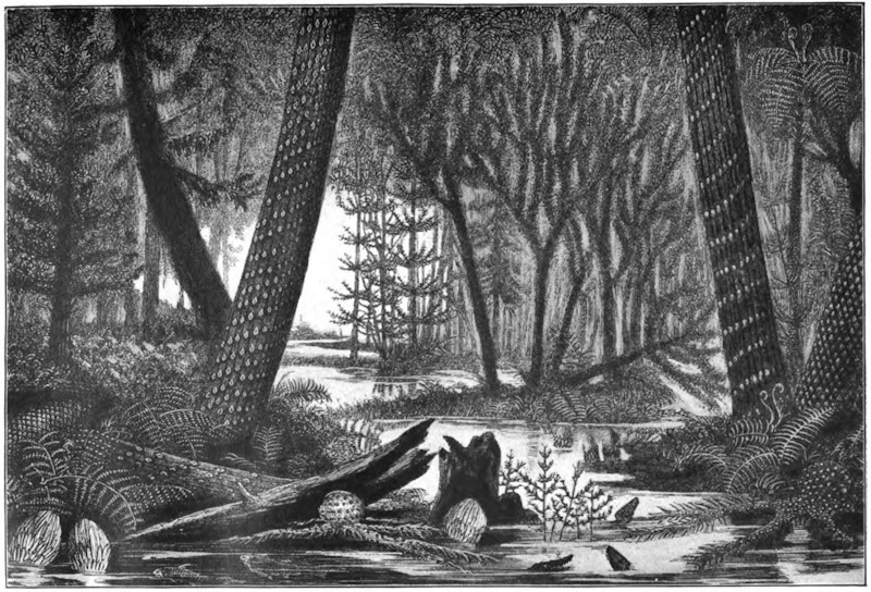
Unfortunately, the phenomena of recent volcanic eruptions under the sea are for the most part inaccessible. Here and there, as in the Bay of Naples, at Etna, among the islands of the Greek Archipelago, and at Tahiti, elevation of the sea-bed has taken place, and brought to the surface beds of tuff or of lava, which have consolidated under water. Both Vesuvius and Etna began their career as submarine volcanoes. The Islands of Santorin and Therasia form the unsubmerged portions of a great crater-rim rising round a crater which descends 1,278 feet below sea-level.
Confining attention to vents now active, of which the total number may be about 300, the chief facts regarding their distribution over the globe may be thus summarized. (1) Volcanoes occur along the margins of the ocean-basins, particularly along lines of dominant mountain ranges, which either form part of the mainland of the continents or extend as adjacent lines of islands. The vast hollow of the Pacific is girdled with a wide ring of volcanic foci. (2) Volcanoes rise, as a striking feature, from the submarine ridges that traverse the ocean basins. All the oceanic islands are either volcanic or formed of coral, and the scattered coral-islands have in all likelihood been built upon the tops of submarine [526]volcanic cones. (3) Volcanoes are situated not far from the sea. The only exceptions to this rule are certain vents in Manchuria and in the tract lying between Tibet and Siberia; but of the actual nature of these vents very little is yet known. (4) The dominant arrangement of volcanoes is in series along subterranean lines of weakness, as in the chain of the Andes, the Aleutian Islands, and the Malay Archipelago. A remarkable zone of volcanic vents girdles the globe from Central America eastward by the Azores and Canary Islands to the Mediterranean, thence to the Red Sea, and through the chains of islands from the south of Asia to New Zealand and the heart of the Pacific. (5) On a smaller scale the linear arrangement gives place to one in groups, as in Italy, Iceland, and the volcanic islands of the great oceans.
In the European area there are six active volcanoes—Vesuvius, Etna, Stromboli, Volcano, Santorin, and Nisyros. Asia contains twenty-four, Africa ten, North America twenty, Central America twenty-five, and South America thirty-seven. By much the larger number, however, occur on islands in the ocean. In the Arctic Ocean rises the solitary Jan Mayen. On the ridge separating the Arctic and Atlantic basins, the group of Icelandic volcanoes is found. Along the great central ridge of the Atlantic bottom, numerous volcanic vents have risen above the surface of the sea—the Azores, Canary Islands, and the extinct degraded volcanoes of St. Helena, Ascension, and Tristan d’Acunha. On the eastern border lie the volcanic vents of the islands off the [527]African coast, and to the west those of the West Indian Islands. Still more remarkable is the development of volcanic energy in the Pacific area. From the Aleutian Islands southward, a long line of volcanoes, numbering upward of a hundred active vents, extends through Kamtchatka and the Kurile Islands to Japan, whence another numerous series carries the volcanic band far south toward the Malay Archipelago, which must be regarded as the chief centre of the present volcanic activity of our planet. In Sumatra, Java, and adjoining islands, no fewer than fifty active vents occur. The chain is continued through New Guinea and the groups of islands to New Zealand. Even in the Antarctic regions, Mounts Erebus and Terror are cited as active vents; while in the centre of the Pacific Ocean rise the great lava cones of the Sandwich Islands. In the Indian Ocean, the Red Sea, and off the east coast of Africa a few scattered vents appear.
Midway between Sumatra and Java lies a group of small islands, which, prior to 1883, were beautified by the dense forests and glorious vegetation of the tropics. Of these islands Krakatoa was the chief, though even of it but little was known. Its appearance from the sea must, indeed, have been familiar to the crews of the many vessels that navigated the Straits of Sunda, but it was not regularly inhabited. Glowing with tropical verdure, such an [528]island seemed an unlikely theatre for the display of an unparalleled effect of plutonic energy, but yet there were certain circumstances which may tend to lessen our surprise at the outbreak. In the first place, as Professor Judd has so clearly pointed out, not only is Krakatoa situated in a region famous, or perhaps infamous, for volcanoes and earthquakes, but it actually happens to lie at the intersection of two main lines, along which volcanic phenomena are, in some degree, perennial. In the second place, history records that there have been previous eruptions at Krakatoa. The last of these appears to have occurred in May, 1680, but unfortunately only imperfect accounts of it have been preserved. It seems, however, to have annihilated the forests of the island, and to have ejected vast quantities of pumice, which cumbered the seas around. Krakatoa then remained active for a year and a half, after which the mighty fires subsided. The irrepressible tropical vegetation again resumed possession. The desolated islet again became clothed with beauty, and for a couple of centuries reposed in peace.
It was one o’clock in the afternoon of Sunday, August 26, 1883, when Krakatoa commenced a series of gigantic volcanic efforts. Detonations were heard which succeeded each other at intervals of about ten minutes. These were loud enough to penetrate as far as Batavia and Buitenzorg, distant 96 and 100 miles respectively from the volcano. A vast column of steam, smoke, and ashes ascended to a prodigious elevation. It was measured at two P. M. from a ship 76 miles away, and was then judged to be 17 miles high—that [529]is, three times the height of the loftiest mountain in the world. As the Sunday afternoon wore on, the volcanic manifestations became ever fiercer. At 3 P. M. the sounds were loudly heard in a town 150 miles away. At 5 P. M. every ear in the island of Java was engaged in listening to volcanic explosions, which were considered to be of quite unusual intensity even in that part of the world. These phenomena were, however, only introductory. Krakatoa was gathering strength. Between 5 and 6 P. M. the British ship Charles Bal, commanded by Captain Watson, was about ten miles south of the volcano. The ship had to shorten sail in the darkness, and a rain of pumice, in large pieces and quite warm, fell upon her decks. At 7 P. M. the mighty column of smoke is described as having the shape of a pine tree, and as being brilliantly illuminated by electric flashes. The sulphurous air is laden with fine dust, while the lead dropped from a ship in its anxious navigation astounds the leadsman by coming up hot from the bottom of the sea. From sunset on Sunday till midnight the tremendous detonations followed each other so quickly that a continuous roar may be said to have issued from the island. The full terrors of the eruption were now approaching. The distance of 96 miles between Krakatoa and Batavia was not sufficient to permit the inhabitants of the town to enjoy their night’s sleep. All night long the thunders of the volcano sounded like the discharges of artillery at their very doors, while the windows rattled with aerial vibrations.
On Monday morning, August 27, the eruption culminated [530]in four terrific explosions, of which the third, shortly after 10 A. M. Krakatoa time, was by far the most violent. The quantity of material ejected was now so great that darkness prevailed even as far as Batavia soon after 11 A. M., and there was a rain of dust until three in the afternoon. The explosions continued with more or less intensity all the afternoon of Monday and throughout Monday night. They finally ceased at about 2:30 A. M. on Tuesday, August 28. The entire series of grand phenomena thus occupied a little more than thirty-six hours.
It seems to be certain that if all the materials poured forth from Krakatoa during the critical period could be collected together, the mass they would form would be considerably over a cubic mile in volume. It is in the other standards of comparison that the importance of the explosion of Krakatoa is to be sought. The intensity of this outbreak in its last throes was such that mighty sounds were heard and mighty waves arose in the sea for which we can find no parallel. Every part of our globe’s surface felt the pulse of the air-waves, and beautiful optical phenomena made the circuit of the globe even more than once or twice. In these last respects the eruption of Krakatoa is unique.
It appears to me that the most remarkable incident connected with the eruption of Krakatoa was the production of the great air-wave by that particular explosion that occurred at ten o’clock on the morning of Monday, August 27. The great air-wave was truly of cosmical importance, affecting as it did every particle of the atmosphere on our globe.
[531]
The comprehensive series of phenomena wherein the atmosphere of the entire globe participates in an organized vibration has, so far as we know, only once been witnessed, and that was after the greatest outbreak at Krakatoa, at ten o’clock on the morning of August 27. But the ebb and the flow of these mighty undulations are not immediately appreciable to the senses. The great wave, for instance, passed and re-passed and passed again over London, and no inhabitant was conscious of the fact. But the automatic records of the barometer at Greenwich show that the vibration from Krakatoa to its antipodes, and from the antipodes back to Krakatoa, was distinctly perceptible over London not less than six or seven times.
From all parts of Europe, from Berlin to Palermo, from St. Petersburg to Valencia, we obtain the same indications. Fortunately self-recording barometric instruments are now to be found all over the world. Almost all the instruments show distinctly the first great wave from Krakatoa to its antipodes in Central America, and the return wave from the antipodes to Krakatoa. They also all show the second great wave which sped from Krakatoa, as well as the second great wave which returned from the antipodes. Thus, the first four of the oscillations are depicted on upward of forty of the barograms. The fifth and sixth oscillations are also to be distinguished on several of the curves, and even the seventh is certainly established at some few places, of which Kew is one. Then the gradually increasing faintness of the indications renders them unrecognizable, from which we conclude that after seven pulsations our atmosphere [532]had sensibly regained its former condition ere it was disturbed by Krakatoa.
In the whole annals of noise there is nothing which can be compared to the records. Lloyd’s agent at Batavia, 94 miles distant, says that on the morning of August 27 the reports and concussions were deafening. At Carimon, Java Island, reports were heard which led to the belief that some vessel offshore was making signals of distress, and boats were accordingly put out to render succor, but no vessel was found, as the reports were from Krakatoa, at a distance of 355 miles. At Macassar, in Celebes, explosions were heard all over the province. Two steamers were sent out to discover the cause, for the authorities did not then know that what they heard came from Krakatoa, 969 miles away. But mere hundreds of miles will not suffice to exemplify the range of this stupendous siren. In St. Lucia Bay, in Borneo, a number of natives, who had been guilty of murder, thought they heard the sounds of vengeance in the approach of an attacking force. They fled from their village, little fancying that what alarmed them really came from Krakatoa, 1,116 miles distant. All over the island of Timor alarming sounds were heard, and so urgent did the situation appear that the government was aroused, and sent off a steamer to ascertain the cause. The sounds had, however, come 1,351 miles, all the way from Krakatoa. In the Victoria Plains of West Australia the inhabitants were startled by the discharge of artillery—an unwonted noise in that peaceful district—but the artillery was at Krakatoa, 1,700 miles distant. [533]The inhabitants of Daly Waters, in South Australia, were rudely awakened at midnight on Sunday, August 26, by an explosion resembling the blasting of a rock, which lasted for a few minutes. The time and other circumstances show that here again was Krakatoa heard, this time at the monstrous distance of 2,023 miles. But there is undoubted testimony that to distances even greater than 2,023 miles the waves of sound conveyed tidings of the mighty convulsion. Diego Garcia, in the Chagos Islands, is 2,267 miles from Krakatoa, but the thunders traversed even this distance, and created the belief that there must be some ship in distress, for which a diligent but necessarily ineffectual search was made. To pass at once to the most remarkable case of all, we have a report from Mr. James Wallis, chief of police in Rodriguez, that “several times during the night of August 26-27, 1883, reports were heard coming from the eastward, like the distant roar of heavy guns. These reports continued at intervals of between three and four hours.” We have thus the astounding fact that almost across the whole wide extent of the Indian Ocean, that is, to a distance of nearly 3,000 miles (2,968), the sound of the throes of Krakatoa was propagated.
I shall content myself with the mention of three facts in illustration of the great sea waves which accompanied the eruption of Krakatoa. Of these, probably the most unusual is the magnitude of the area over which the undulations were perceived. Thus, to mention but a single instance, and that not by any means an extreme one, we find that the tide gauge [534]at Table Bay reveals waves which, notwithstanding that they have traveled 5,100 miles from Krakatoa, have still a range of eighteen inches when they arrive at the southern coast of Africa. The second fact that I mention illustrates the magnitude of the seismic waves by the extraordinary inundations that they produced on the shores of the Straits of Sunda. Captain Wharton shows that the waves, as they deluged the land, must have been fifty feet, or, in one well authenticated case, seventy-two feet high. It was, of course, these vast floods which caused the fearful loss of life. The third illustrative fact concerns the fate of a man-of-war, the Berouw. This unhappy vessel was borne from its normal element and left high and dry in Sumatra, a mile and three-quarters inland, and thirty feet above the level of the sea.
During the crisis on August 26-27, the volume of material blown into the air was sufficiently dense to obscure the coasts of Sumatra to such a degree that at 10 A. M. the darkness there is stated to have been more intense than it is even in the blackest of nights. The fire-dust ascended to an elevation which, as we have already mentioned, is estimated to have been as much as seventeen miles. Borne aloft into these higher regions of our atmosphere, the clouds of dust at once became the sport of the winds and the currents which may be found there. If we had not previously known the prevailing tendency of the winds at these elevations and in these latitudes, the journey of the Krakatoa dust would have taught us.
It seems certain that, having attained their lofty elevation, the mighty clouds of dust were seized by [535]easterly winds, and were swept along with a velocity which may not improbably be normal at a height of twenty miles above the earth’s surface.
It appears that this cloud of dust started immediately from Krakatoa for a series of voyages round the world. The highway which it at first pursued may, for our present purpose, be sufficiently defined by the Tropic of Cancer and the Tropic of Capricorn, though it hardly approached these margins at first. Westward the dust of Krakatoa takes its way. In three days it had crossed the Indian Ocean and was rapidly flying over the heart of Equatorial Africa; for another couple of days it was making a transatlantic journey; and then it might be found, for still a couple of days more, over the forests of Brazil ere it commenced the great Pacific voyage which brought it back to the East Indies. The dust of Krakatoa had put a girdle round the earth in thirteen days! The shape of the cloud appears to have been elongated, so that it took two or three days to complete the passage over any stated place.
It remains to give some brief account of the optical phenomena due to the presence of dust, unusual both in quantity and in character, in the upper atmosphere. Beautiful pictures show the twilight and after-glow effects as seen by Mr. W. Ascroft on the bank of the Thames a little west of London, on the evening of November 26, 1883. Analogous phenomena were seen almost universally during November and December in the same year. Who is there that does not remember the wondrous loveliness of the twilights and the after-glows during [536]that remarkable winter! These appearances at sunrise and sunset are only the more generally recognized of a whole system of strange optical phenomena. One of the most striking indications of the presence of the dust-stream in its first voyage round the earth was given by the strange blue hue it imparted to the sun. The dust-stream was also visible in its rapid voyages as a lofty haze or extensive cloud of cirro-stratus. Then, too, strange halos were often seen, there were occasional blue or green moons, and the sun was sometimes glorified by a corona that had its origin in our atmosphere. Everywhere in the world there were remarkable features in the sky that winter: from Tierra del Fuego to Lake Superior; from China to the Gulf of Guinea; from Panama to Australia. Wherever on land there were inhabitants with sufficient intelligence to note the unusual, wherever on the sea there were mariners who kept a careful log, from all such observers we learn that in the autumn and winter months following the great eruption of Krakatoa, there were extraordinary manifestations witnessed in the heavens.
The term volcanic action (volcanism or volcanicity) embraces all the phenomena connected with the expulsion of heated materials from the interior of the earth to the surface. Among these phenomena, some possess an evanescent character, while others leave permanent proofs of their existence. It is naturally to the latter that the geologist gives chief [537]attention, for it is by their means that he can trace former phases of volcanic activity in regions where, for many ages, there have been no volcanic eruptions. In the operations of existing volcanoes, he can observe only superficial manifestations of volcanic action. But examining the rocks of the earth’s crust, he discovers that amid the many terrestrial revolutions which geology reveals, the very roots of former volcanoes have been laid bare, displaying subterranean phases of volcanism which could not be studied in any modern volcano. Hence an acquaintance only with active volcanoes will not afford a complete knowledge of volcanic action. It must be supplemented and enlarged by an investigation of the traces of ancient volcanoes preserved in the crust of the earth.
The word “volcano” is applied to a conical hill or mountain (composed mainly or wholly of erupted materials), from the summit and often also from the sides of which hot vapors issue, and ashes and streams of molten rock are intermittently expelled. The term “volcanic” designates all the phenomena essentially connected with one of these channels of communication between the surface and the heated interior of the globe. Yet there is good reason to believe that the active volcanoes of the present day do not afford by any means a complete type of volcanic action. The first effort in the formation of a new volcano is to establish a fissure in the earth’s crust. A volcano is only one vent or group of vents established along the line of such a fissure. But in many parts of the earth, alike in the Old World and the [538]New, there have been periods in the earth’s history when the crust was rent into innumerable fissures over areas thousands of square miles in extent, and when the molten rock, instead of issuing, as it does at a modern volcano, in narrow streams from a central elevated cone, welled out from numerous small vents along the rents, and flooded enormous tracts of country without forming any mountain or conspicuous volcanic cone in the usual sense of these terms. Of these “fissure-eruptions,” apart from central volcanic cones, no examples appear to have occurred within the times of human history, except in Iceland, where vast lava-floods issued from a fissure in 1783. They can best be studied from the remains of former convulsions.
The materials erupted from volcanic vents may be classed as (1) gases and vapors, (2) water, (3) lava, (4) fragmentary substances.
Gases and vapors exist dissolved in the molten magma within the earth’s crust. They play an important part in volcanic activity, showing themselves in the earliest stages of a volcano’s history, and continuing to appear for centuries after all other subterranean action has ceased. By much the most abundant of them all is water-gas, which, ultimately escaping as steam, has been estimated to form 999-1000ths of the whole cloud that hangs over an active volcano. In great eruptions, steam rises in prodigious quantities, and is rapidly condensed into a heavy rainfall. M. Fouqué calculated that, during 100 days, one of the parasitic cones on Etna had ejected vapor enough to form, if condensed, 2,100,000 cubic [539]metres (462,000,000 gallons) of water. But even from volcanoes which, like the Solfatara of Naples, have been dormant for centuries, steam sometimes still rises without intermission and in considerable volume. Jets of vapor rush out from clefts in the sides and bottom of a crater with a noise like that made by the steam blown off by a locomotive. The number of these funnels or “fumaroles” is often so large, and the amount of vapor so abundant, that only now and then, when the wind blows the dense cloud aside, can a momentary glimpse be had of a part of the bottom of the crater; while at the same time the rush and roar of the escaping steam remind one of the din of some vast factory. Aqueous vapor rises likewise from rents on the outside of the volcanic cone. It issues so copiously from some flowing lavas that the stream of rock may be almost concealed from view by the cloud; and it continues to escape from fissures of the lava, far below the point of exit, for a long time after the rock has solidified and come to rest.
Abundant discharges of water accompany some volcanic explosions. Three sources of this water may be assigned: (1) from the melting of snow by a rapid accession of temperature previous to or during an eruption; this takes place from time to time on Etna, in Iceland, and among the snowy ranges of the Andes, where the cone of Cotopaxi is said to have been entirely divested of its snow in a single night by the heating of the mountain; (2) from the condensation of the vast clouds of steam which are discharged during an eruption; this undoubtedly is the chief source [540]of the destructive torrents so frequently observed to form part of the phenomena of a great volcanic explosion; and (3) from the disruption of reservoirs of water filling subterranean cavities, or of lakes occupying crater-basins; this has several times been observed among the South American volcanoes, where immense quantities of dead fish, which inhabited the water, have been swept down with the escaping torrents. The volcano of Agua in Guatemala received its name from the disruption of a crater-lake at its summit by an earthquake in 1540, whereby a vast and destructive debacle of water was discharged down the slopes of the mountain. In the beginning of the year 1817, an eruption took place at the large crater of Idjèn, one of the volcanoes of Java, whereby a steaming lake of hot acid water was discharged with frightful destruction down the slopes of the mountain. After the explosion, the basin filled again with water, but its temperature was no longer high.
The term lava is applied generally to all the molten rocks of volcanoes. The use of the word in this broad sense is of great convenience in geological descriptions, by directing attention to the leading character of the rocks as molten products of volcanic action, and obviating the confusion and errors which are apt to arise from an ill-defined or incorrect lithological terminology.
While still flowing or not yet cooled, lavas differ from each other in the extent to which they are impregnated with gases and vapors. Some appear to be saturated, others contain a much smaller gaseous impregnation; and hence arise important distinctions in [541]their behavior. After solidification, lavas present some noticeable characters, then easily ascertainable. (1) Their average specific gravity may be taken as ranging between 2.37 and 3.22. (2) The heavier varieties contain much magnetic or titaniferous iron, with augite and olivine, their composition being basic, and their proportion of silica averaging about 45 to 55 per cent. (3) Lavas differ much in structure and texture. (4) Lavas vary greatly in color and general external aspect. The heavy basic kinds are usually dark gray, or almost black, though, on exposure to the weather, they acquire a brown tint from the oxidation and hydration of their iron. Their surface is commonly rough and ragged, until it has been sufficiently decomposed by the atmosphere to crumble into soil which, under favorable circumstances, supports a luxuriant vegetation. The less dense lavas, such as phonolites and trachytes, are frequently paler in color, sometimes yellow or buff, and decompose into light soils; but the obsidians present rugged black sheets of rock, roughened with ridges and heaps of gray froth-like pumice. Some of the most brilliant surfaces of color in any rock-scenery on the globe are to be found among volcanic rocks. The walls of active craters glow with endless hues of red and yellow. The Grand Cañon of the Yellowstone River has been dug out of the most marvelously tinted lavas and tuffs.
Volcanic action may be either constant or periodic. Stromboli, in the Mediterranean, so far as we know, has been uninterruptedly emitting hot stones and steam, from a basin of molten lava, since the earliest [542]period of history. Among the Moluccas, the volcano Sioa, and in the Friendly Islands, that of Tofua, have never ceased to be in eruption since their first discovery. The lofty cone of Sangay, among the Andes of Quito, is always giving off hot vapors; Cotopaxi, too, is ever constantly active. But, though examples of unceasing action may thus be cited from widely different quarters of the globe, they are nevertheless exceptional. The general rule is that a volcano breaks out from time to time with varying vigor, and after longer or shorter intervals of quiescence.
It is usual to class volcanoes as active, dormant, and extinct. This arrangement, however, often presents considerable difficulty in its application. An active volcano can not of course be mistaken, for even when not in eruption, it shows by its discharge of steam and hot vapors that it might break out into activity at any moment. But in many cases it is impossible to decide whether a volcano should be called extinct or only dormant. The volcanoes of Silurian age in Wales, of Carboniferous age in Ireland, of Permian age in the Harz, of Miocene age in the Hebrides, of younger Tertiary age in the Western States and Territories of North America, are certainly all extinct. But the older Tertiary volcanoes of Iceland are still represented there by Skaptar-Jökull, Hecla, and their neighbors. Somma, in the First Century of the Christian era, would have been naturally regarded as an extinct volcano. Its fires had never been known to have been kindled; its vast crater was a wilderness of wild vines and brushwood, haunted, no doubt, by wolf and wild boar. Yet in a [543]few days, during the autumn of the year 79, the half of the crater walls was blown out by a terrific series of explosions, the present Vesuvius was then formed within the limits of the earlier crater, and since that time volcanic action has been intermittently exhibited up to the present day. Some of the intervals of quietude, however, have been so considerable that the mountain might then again have been claimed as an extinct volcano. Thus, in the 131 years between 1500 and 1631, so completely had eruptions ceased that the crater had once more become choked with copse-wood. A few pools and springs of very salt and hot water remained as memorials of the former condition of the mountain. But this period of quiescence closed with the eruption of 1631—the most powerful of all the known explosions of Vesuvius, except the great one of 79.
In short, no essential distinction can be drawn between dormant and extinct volcanoes. Volcanic action is apt to show itself again and again, even at vast intervals, within the same regions and over the same sites. The dormant or waning condition of a volcano, when only steam and various gases and sublimates are given off, is sometimes called the Solfatara phase, from the well-known dormant crater of that name near Naples.
The interval between two eruptions of an active volcano shows a gradual augmentation of energy. The crater, emptied by the last discharge, has its floor slowly upraised by the expansive force of the lava-column underneath. Vapors rise in constant outflow, accompanied sometimes by discharges of dust or [544]stones. Through rents in the crater-floor red-hot lava may be seen only a few feet down. Where the lava is maintained at or above its fusion-point and possesses great liquidity, it may form boiling lakes, as in the great crater of Kilauea, where acres of seething lava may be watched throwing up fountains of molten rock, surging against the walls and re-fusing large masses that fall into the burning flood. The lava-column inside the pipe of a volcano is all this time gradually rising, until some weak part of the wall allows it to escape, or until the pressure of the accumulated vapors becomes great enough to burst through the hardened crust of the crater-floor and give rise to the phenomena of an eruption.
Kluge has sought to trace a connection between the years of maximum and minimum sun-spots and those of greatest and feeblest volcanic activity, and has constructed lists to show that years which have been specially characterized by terrestrial eruptions have coincided with those marked by few sun-spots and diminished magnetic disturbance. Such a connection can not be regarded as having yet been satisfactorily established. Again, the same author has called attention to the frequency and vigor of volcanic explosions at or near the time of the August meteoric shower. But in this case, likewise, the cited examples can hardly yet be looked upon as more than coincidences.
At many volcanic vents the eruptive energy manifests itself with more or less regularity. At Stromboli, which is constantly in an active state, the explosions occur at intervals varying from three or four [545]to ten minutes and upward. A similar rhythmical movement has been often observed during the eruptions at other vents which are not constantly active. Volcano, for example, during its eruption of September, 1873, displayed a succession of explosions which followed each other at intervals of from twenty to thirty minutes. At Etna and Vesuvius a similar rhythmical series of convulsive efforts has often been observed during the course of an eruption. Among the volcanoes of the Andes a periodic discharge of steam has been observed; Mr. Whymper noticed outrushes of steam to proceed at intervals of from twenty to thirty minutes from the summit of Sangai, while during his inspection of the great crater of Cotopaxi, this volcano was seen to blow off steam at intervals of about half an hour. At the eruption of the Japanese volcano, Oshima, in 1877, Mr. Milne observed that the explosions occurred nearly every two seconds, with occasional pauses of 15 or 20 seconds. Kilauea, in Hawaii, seems to show a regular system of grand eruptive periods. Dana has pointed out that outbreaks of lava have taken place from that volcano at intervals of from eight to nine years, this being the time required to fill the crater up to the point of outbreak, or to a depth of 400 or 500 feet.
The approach of an eruption is not always indicated by any premonitory symptoms, for many tremendous explosions are recorded to have taken place in different parts of the world without perceptible warning. Much in this respect would appear to depend upon the condition of liquidity of the lava, and [546]the amount of resistance offered by it to the passage of the escaping vapors through its mass. In Hawaii, where the lavas are remarkably liquid, vast outpourings of them have taken place quietly without earthquakes during the present century. But even there the great eruption of 1868 was accompanied by violent earthquakes.
The eruptions of Vesuvius are often preceded by failure or diminution of wells and springs. But more frequent indications of an approaching outburst are conveyed by sympathetic movements of the ground. Subterranean rumblings and groanings are heard; slight tremors succeed, increasing in frequency and violence till they become distinct earthquake shocks. The vapors from the crater grow more abundant as the lava-column in the pipe or funnel of the volcano ascends, forced upward and kept in perpetual agitation by the passage of elastic vapors through its mass. After a long previous interval of quiescence, there may be much solidified lava toward the top of the funnel, which will restrain the ascent of the still molten portion underneath. A vast pressure is thus exercised on the sides of the cone, which, if too weak to resist, will open in one or more rents, and the liquid lava will issue from the outer slope of the mountain; or the energies of the volcano will be directed toward clearing the obstruction in the chief throat, until with tremendous explosions, and the rise of a vast cloud of dust and fragments, the bottom and sides of the crater are finally blown out, and the top of the cone disappears. The lava may now escape from the lowest part of the lip of the crater, while, [547]at the same time, immense numbers of red-hot bombs, scoriæ, and stones are shot up into the air. The lava at first rushes down like one or more rivers of melted iron, but, as it cools, its rate of motion lessens. Clouds of steam rise from its surface, as well as from the central crater. Indeed, every successive paroxysmal convulsion of the mountain is marked, even at a distance, by the rise of huge ball-like wreaths or clouds of steam, mixed with dust and stones, forming a column which towers sometimes a couple of miles or more above the summit of the cone. By degrees these eructations diminish in frequency and intensity. The lava ceases to issue, the showers of stones and dust decrease, and after a time, which may vary from hours to days or months, even in the régime of the same mountain, the volcano becomes once more tranquil.
The convulsions which culminate in the formation of a volcano usually split open the terrestrial crust by a more or less nearly rectilinear fissure, or by a system of fissures. In the subsequent progress of the mountain, the ground at and around the focus of action is liable to be again and again rent open by other fissures. These tend to diverge from the focus; but around the vent where the rocks have been most exposed to concussion, the fissures sometimes intersect each other in all directions. In the great eruption of Etna, in the year 1669, a series of six parallel fissures opened on the side of the mountain. One of these, with a width of two yards, ran for a distance of 12 miles, in a somewhat winding course, to within a mile of the top of the cone.
In the deeper portions of a volcanic vent the convulsive [548]efforts of the lava-column to force its way upward must often produce lateral as well as vertical rifts, and into these the molten material will rush, exerting as it goes an enormous upward pressure on the mass of rock overlying it. At a modern volcano these subterranean manifestations can not be seen, but among the volcanoes of Tertiary and older times they have been revealed by the progress of denudation.
Though lava very commonly issues from the lateral fissures on a volcanic cone, it may sometimes approach the surface in them without actually flowing out. The great fissure on Etna in 1669, for example, was visible even from a distance, by the long line of vivid light which rose from the incandescent lava within. Again, it frequently happens that minor volcanic cones are thrown up on the line of a fissure, either from the congelation of the lava round the point of emission, or from the accumulation of ejected scoriæ round the fissure-vent. One of the most remarkable examples of this kind is that of the Laki fissure in Iceland, the whole length of which (12 miles) bristles with small cones and craters almost touching each other.
Apart from the appearance of visible fissures, volcanic energy may be, as it were, concentrated on a given point, which will usually be the weakest in the structure of that part of the terrestrial crust, and from which the solid rock, shattered into pieces, is hurled into the air by the enormous expansive energy of the volcanic vapors. The history of the cone of Vesuvius brings before us a long series of such explosions, [549]beginning with that of A. D. 79, and coming down to the present day. Even now, in spite of all the lava and ashes poured out during the last eighteen centuries, it is easy to see how stupendous must have been that earliest explosion by which the southern half of the ancient crater was blown out. At every successive important eruption, a similar but minor operation takes place within the present cone. The hardened cake of lava forming the floor is burst open, and with it there usually disappears much of the upper part of the cone, and sometimes, as in 1872, a large segment of the crater-wall. The islands of Santorin bring before us evidence of a prehistoric catastrophe of a similar nature, by which a large volcanic cone was blown up. The existing outer islands are a chain of fragments of the periphery of the cone, the centre of which is now occupied by the sea. In the year 1538 a new volcano, Monte Nuovo, was formed in twenty-four hours on the margin of the Bay of Naples. An opening was drilled by successive explosions, and such quantities of stones, scoriæ, and ashes were thrown out from it as to form a hill that rose 440 English feet above the sea-level, and was more than a mile and a half in circumference.
A communication having been opened, either by fissuring or explosion, between the heated interior and the surface, fragmentary materials are commonly ejected from it, consisting at first mainly of the rocks through which the orifice has been opened, afterward of volcanic substances. In a great eruption, vast numbers of red-hot stones are shot up into the air, and fall back partly into the crater and [550]partly on the outer slopes of the cone. According to Sir W. Hamilton, cinders were thrown by Vesuvius, during the eruption of 1779, to a height of 10,000 feet. Instances are known where large stones, ejected obliquely, have described huge parabolic curves in the air, and fallen at a great distance. Stones eight pounds in weight occur among the ashes which buried Pompeii. The volcano of Antuco in Chili is said to send stones flying to a distance of thirty-six miles, Cotopaxi is reported to have hurled a 200-ton block nine miles, and the Japanese volcano, Asama, is said to have ejected many blocks of stone measuring from 40 to more than 100 feet in diameter.
But in many great eruptions, besides a constant shower of stones and scoriæ, a vast column of exceedingly fine dust rises out of the crater, sometimes to a height of several miles, and then spreads outward like a sheet of cloud. The remarkable fineness of this dust may be understood from the fact that during great volcanic explosions no boxes, watches, or close-fitting joints have been found to be able to exclude it. Mr. Whymper collected some dust that fell sixty-five miles away from Cotopaxi, and which was so fine that from 4,000 to 25,000 particles were required to weigh a grain. So dense is the dust-cloud as to obscure the sun, and for days together the darkness of night may reign for miles around the volcano. The eruption of Cotopaxi, on 26th June, 1877, began by an explosion that sent up a column of fine ashes to a prodigious height into the air, where it rapidly spread out and formed so dense a canopy as to throw the region below it into total darkness. So [551]quickly did it diffuse itself, that in an hour and a half a previously bright morning became at Quito, thirty-three miles distant, a dim twilight, which in the afternoon passed into such darkness that the hand placed before the eye could not be seen. At Guayaquil, on the coast, 150 miles distant, the shower of ashes continued till the 1st of July. Dr. Wolf collected the ashes daily, and estimated that at that place there fell 315 kilogrammes on every square kilometre during the first thirty hours, and on the 30th of June, 209 kilogrammes in twelve hours.
One of the most stupendous outpourings of volcanic ashes on record took place, after a quiescence of twenty-six years, from the volcano Coseguina, in Nicaragua, during the early part of the year 1835. On that occasion, utter darkness prevailed over a circle of thirty-five miles radius, the ashes falling so thickly that, even eight leagues from the mountain, they covered the ground to a depth of about ten feet. It was estimated that the rain of dust and sand fell over an area at least 270 geographical miles in diameter. Some of the finer materials, thrown so high as to come within the influence of an upper air-current, were borne away eastward, and fell, four days afterward, at Kingston, in Jamaica—a distance of 700 miles. During the great eruption of Sumbawa, in 1815, the dust and stones fell over an area of nearly one million square miles, and were estimated by Zollinger to amount to fully fifty cubic miles of material, and by Junghuhn to be equal to one hundred and eighty-five mountains like Vesuvius. Toward the end of the Eighteenth Century, during a [552]time of great disturbance among the Japanese volcanoes, one of them, Sakurajima, threw out so much pumiceous material that it was possible to walk a distance of twenty-three miles upon the floating débris in the sea.
The varying degree of liquidity or viscosity of the lava probably modifies the force of explosions, owing to the different amounts of resistance offered to the upward passage of the absorbed gases and vapors. Thus explosions and accompanying scoriæ are abundant at Vesuvius, where the lavas are comparatively viscid; they are almost unknown at Kilauea, where the lava is remarkably liquid.
In tranquil conditions of a volcano, the steam, whether collecting into larger or smaller vesicles, works its way upward through the substance of the molten lava, and as the elasticity of this compressed vapor overcomes the pressure of the overlying lava, it escapes at the surface, and there the lava is thus kept in ebullition. But this comparatively quiet operation, which may be watched within the craters of many active volcanoes, does not produce clouds of fine dust. The collision or friction of millions of stones ascending and descending in the dark column above the crater must doubtless cause much dust and sand. But the explosive action of steam is probably also an immediate cause of much trituration. The aqueous vapor or water-gas which is so largely dissolved in many lavas must exist within the lava-column, under an enormous pressure, at a temperature far above its critical point, even at a white heat, and therefore possibly in a state of dissociation. [553]The sudden ascent of lava so constituted relieves the pressure rapidly without sensibly affecting the temperature of the mass. Consequently, the white-hot gases or vapors at length explode, and reduce the molten mass to the finest powder, like water shot out of a gun.
As every shower of dust and sand adds to the height of the ground on which it falls, thick volcanic accumulations may be formed far beyond the base of the mountain. The volcano of Sangay, in Ecuador, for instance, has buried the country around it to a depth of 4,000 feet under its ashes. In such loose deposits are entombed trees and other kinds of vegetation, together with the bodies of animals, as well as the works of man. In some cases, where the layer of volcanic dust is thin, it may merely add to the height of the soil, without sensibly interfering with the vegetation. But it has been observed at Santorin that though this is true in dry weather, the fall of rain with the dust at once acts detrimentally. On the 3d of June, 1866, the vines were there withered up, as if they had been burned, along the track of the smoke cloud. By the gradual accumulation of volcanic ashes, new geological formations arise which, in their component materials, not only bear witness to the volcanic eruptions that produced them, but preserve a record of the land-surfaces over which they spread. In the third place, besides the distance to which the fragments may be hurled by volcanic explosions, or to which they may be diffused by the ordinary aerial movements, we have to take into account the vast spaces across which the finer dust is [554]sometimes borne by upper air-currents. In the instance already cited, ashes from Coseguina fell 700 miles away, having been carried all that long distance by a high counter-current of air, moving apparently at the rate of about seven miles an hour in an opposite direction to that of the wind which blew at the surface. By the Sumbawa eruption, also referred to above, the sea west of Sumatra was covered with a layer of ashes two feet thick. On several occasions ashes from the Icelandic volcanoes have fallen so thickly between the Orkney and Shetland Islands, that vessels passing there have had the unwonted deposit shoveled off their decks in the morning. In the year 1783, during the memorable eruption of Skaptar-Jökull, so vast an amount of fine dust was ejected that the atmosphere over Iceland continued loaded with it for months afterward. It fell in such quantities over parts of Caithness—a distance of 600 miles—as to destroy the crops; that year is still spoken of by the inhabitants as the year of “the ashie.” Traces of the same deposit have been observed in Norway, and even as far as Holland. Hence it is evident that volcanic accumulations may take place in regions many hundreds of miles distant from any active volcano. A single thin layer of volcanic detritus in a group of sedimentary strata would not thus of itself prove the existence of contemporaneous volcanic action in its neighborhood.
At its exit from the side of a volcano, lava glows with a white heat, and flows with a motion which has been compared to that of honey or of melted iron. [555]It soon becomes red, and like a coal fallen from a hot fireplace rapidly grows dull as it moves along, until it assumes a black, cindery aspect. At the same time the surface congeals, and soon becomes solid enough to support a heavy block of stone. The aspect of the stream varies with the composition and fluidity of the lava, form of the ground, angle of slope, and rapidity of flow. Viscous lavas, like those of Vesuvius, break up along the surface into rough brown or black cinder-like slags and irregular ragged cakes, bristling with jagged points, which, in their onward motion, grind and grate against each other with a harsh, metallic sound, sometimes rising into rugged mounds or becoming seamed with rents and gashes, at the bottom of which the red-hot glowing lava may be seen. In lavas possessing somewhat greater fluidity, the surface presents froth-like, curving lines, as in the scum of a slowly flowing river, or is arranged in curious ropy folds, as the layers have successively flowed over each other and congealed. A large area which has been flooded with lava is perhaps the most hideous and appalling scene of desolation anywhere to be found on the surface of the globe.
A lava-stream usually spreads out as it descends from its point of escape, and moves more slowly. Its sides look like huge embankments, or like some of the long mounds of “clinkers” in a great manufacturing district. The advancing end is often much steeper, creeping onward like a great wall or rampart, down the face of which the rough blocks of hardened lava are ever rattling.
[556]
In a lofty volcano, lava occasionally rises to the lip of the crater and flows out there; but more frequently it escapes from some fissure or orifice in a weak part of the cone. In minor volcanoes, on the other hand, where the explosions are less violent, and where the thickness of the cone in proportion to the diameter of the funnel is often greater, the lava very commonly rises into the crater. Should the crater-walls be too weak to resist the pressure of the molten mass, they give way, and the lava rushes out from the breach. This is seen to have happened in several of the puys of Auvergne. But if the crater be massive enough to withstand the pressure, the lava may at last flow out from the lowest part of the rim.
As soon as the molten rock reaches the surface, the superheated water-vapor or gas dissolved within its mass escapes copiously, and hangs as a dense white cloud over the moving current. The lava-streams of Vesuvius sometimes appear with as dense a steam-cloud at their lower ends as that which escapes at the same time from the main crater. Even after the molten mass has flowed several miles, steam continues to rise abundantly both from its end and from numerous points along its surface, and continues to do so for many weeks, months, or it may be for several years.
Should the point of escape of a lava-stream lie well down on the cone, far below the summit of the lava-column in the funnel, the molten rock, on its first escape, driven by hydrostatic pressure, will sometimes spout up high into the air—a fountain of molten rock. This was observed in 1794 on Vesuvius, [557]and in 1832 on Etna. In the eruption of 1852 at Mauna Loa, an unbroken fountain of lava, from 200 to 700 feet in height and 1,000 feet broad, burst out at the base of the cone. Similar “geysers” of molten rock have subsequently been noticed in the same region. Thus in March and April, 1868, four fiery fountains, throwing lava to heights varying from 500 to 1,000 feet, continued to play for several weeks. According to Mr. Coan, such outbursts take place from the bottom of a column of lava 3,000 feet high. The volcano of Mauna Loa strikingly illustrates another feature of volcanic dynamics in the position and outflow of lava. It bears upon its flanks at a distance of 20 miles, but 10,000 feet lower, the huge crater Kilauea. As Dana has pointed out, these orifices form part of one mountain, yet the column of lava stands 10,000 feet higher in one conduit than in the other. On a far smaller scale the same independence occurs among the several pipes of some of the geysers in the Yellowstone region of North America.
The rate of movement is regulated by the fluidity of the lava, by its volume, and by the form and inclination of the ground. Hence, as a rule, a lava-stream moves faster at first than afterward, because it has not had time to stiffen, and its slope of descent is usually steeper than further down the mountain. One of the most fluid and swiftly flowing lava-streams ever observed on Vesuvius was that erupted on 12th August, 1805. It is said to have rushed down a space of 3 Italian (3⅔ English) miles in the first four minutes, but to have widened out and [558]moved more slowly as it descended, yet finally to have reached Torre del Greco in three hours. A lava erupted by Mauna Loa in 1852 went as fast as an ordinary stage-coach, or fifteen miles in two hours; but some of the lavas from that mountain have in parts of their course moved with double that rapidity.
In some cases, lava escaping from craters or fissures comes to rest before reaching the base of the slopes, like the obsidian current which has congealed on the side of the little volcanic island of Volcano. In other instances, the molten rock not only reaches the plains, but flows for many miles away from the point of eruption. Sartorius von Waltershausen computed the lava emitted by Etna in 1865 at 92 millions of cubic metres, that of 1852 at 420 millions, that of 1669 at 980 millions, and that of a prehistoric lava-stream near Randazzo at more than 1,000 millions. The most stupendous outpouring of lava on record was that which took place in Iceland in the year 1783. Successive streams issued from a fissure about 12 miles long, filling up river gorges which were sometimes 600 feet deep and 200 feet broad, and advancing into the alluvial plains in lakes of molten rock 12 to 15 miles wide and 100 feet deep. Two currents of lava which, filling up the valley of the Skapta, escaped in nearly opposite directions, extended for 45 and 50 miles respectively, their usual thickness being 100 feet. Bischof estimated that the total amount of lava poured forth during this single eruption “surpassed in magnitude the bulk of Mont Blanc.”
[559]
The varying degrees of liquidity are manifested in a characteristic way on the surface of lava. Thus, in the great lava-pools of Hawaii, the rock exhibits a remarkable liquidity, throwing up fountains of molten rock to a height of 300 feet or more. During its ebullition in the crater-pools, jets and driblets a quarter of an inch in diameter are tossed up, and, falling back on one another, make “a column of hardened tears of lava,” one of which was found to have attained a height of 40 feet, while in other places the jets thrown up and blown aside by the wind give rise to long threads of glass which lie thickly together like mown grass, and are known by the natives under the name of “Pele’s Hair,” after one of their divinities. Yet, although the ebullition is caused by the uprise and escape of highly heated vapors, there is no cloud over the boiling lake itself, heavy white vapor only escaping at different points along the edge.
It appears, from the accurate records of such phenomena which have been kept within recent periods, that earthquakes are of much more frequent occurrence than is commonly supposed. Upward of three thousand earthquakes are recorded as having occurred within the first half of the Nineteenth Century—an average of more than one for every week throughout the entire period. But not more than one in forty is of considerable importance, by far the greater number consisting of such slight shocks as [560]are occasionally experienced in Great Britain and other countries favored with a like immunity in this regard. An important earthquake, however, in some part of the world or other, appears, from the above average, to occur once in every eight months. In Europe alone, where a more complete record of such occurrences is obtainable than in other parts of the world, as many as 320 distinct earthquakes are recorded to have occurred within a period of ten years (1833-42)—an average of thirty-two annually, and of one such shock for every ten days throughout the period.
[The geographical area within which shocks of earthquakes are experienced is a widely spread one, and does not appear to undergo any material change (if, indeed, any change whatever) as to its limits. At any rate, the regions in which violent earthquakes are recorded to have occurred in former times are those in which such disturbances are of most frequent recurrence at the present day. One of the most striking evidences in favor of the supposition that the volcanic eruption is due to the same deeply seated cause which produces the shock of the earthquake, is afforded by the fact, that all the volcanoes which have been in eruption within the modern period of geology are found within regions liable to earthquakes, and, for the most part, to violent shocks.]
Regarding the earthquake and the volcanic eruption as the manifestation, under different conditions, of the earth’s internal fires, we readily mark out upon the globe the great regions of geographical distribution in the case of such phenomena. The most widely extended of these coincides with the circuit of the Pacific Ocean. Along the entire western coast of the New World, from Tierra del Fuego to the peninsula of Alaska and the neighborhood of the [561]Aleutian Islands, shocks of earthquakes are known to occur; and, within a large portion of the space, vents of active eruption are found. The subterranean igneous force is, indeed, much more powerfully displayed in the southern than in the northern half of the American continent, and the active volcanoes that occur within the limits referred to are nearly all found amid the cordilleras of the Andes, or upon the plateaus of the Mexican isthmus. One of the Mexican volcanoes—Jorullo—is especially deserving of notice, from the circumstance of its having first risen above the surrounding plain by the accumulation of volcanic matter during an eruption in the year 1759.
The Aleutian Islands connect the volcanic region of the eastern Pacific with that which extends along its western shores. In the latter case, however, it is upon the peninsular regions, or in the chains of islands that adjoin the mainland, that the igneous force is displayed. Kamtchatka, the Kurile Islands, Yesso, the Japanese group, and the entire region of the Malay Archipelago, exhibit the presence of igneous force below the ground. Seven active volcanoes occur in Kamtchatka. The Japanese Archipelago is said to contain at least twenty-seven active volcanoes, eight of them upon Yesso and the adjacent islets. Between Japan and the Loo-choo group is Sulphur Island, an insular volcano, from which smoke is constantly emitted.
The Philippine Islands, in which earthquakes are of frequent occurrence, prolong the volcanic chain to the southward. Thence it is traced, at intervals, along the northern shores of New Guinea, and [562]through the prolonged chains of the Solomon Islands, and the New Hebrides, to the North Island of New Zealand. Slight shocks of earthquake have also been experienced within the southern and eastwardly portions of the Australian mainland.
The numerous volcanoes of the Malay Archipelago, the whole area of which is liable to frequent earthquake shocks, often of the most destructive violence, belong to the eastern portion of this region, and display the agency of subterranean heat on the grandest scale. The island of Java alone contains forty-three active volcanoes, ranging in a linear direction throughout its length. The volcanic chain of Java is prolonged to the eastward through the Lesser Sunda Islands (Sumbawa, etc.), in which direction it is united with that which borders the Pacific waters. There are active volcanoes on an island in the Gulf of Siam, besides the well-known crater of Barren Island, in the Bay of Bengal. The region adjoining the last-named body of water, together with the whole of northern India, is of frequent liability to earthquakes, some of them (as that of Cutch, in 1819) of the most destructive violence. The volcanic island of Mayotta (Comoro group), the active Piton of Réunion or Bourbon Island, and the hot springs and extinct craters of St. Paul and Amsterdam Islands, in a high southern latitude of the Indian Ocean, constitute points which indicate, at distant intervals, the continuity of the volcanic chain.
The southwestern portion of Asia, the southern shores of Europe, and the northwestwardly portion of the African mainland, fall within this region on [563]the one side, as the islands of the West Indies do upon the other. The entire breadth of the Atlantic Ocean, as well as the circuit of the Mediterranean, is thus included within its limits. To the northward, the numerous volcanoes of Iceland, and the more distant cone of Jan Mayen Island, lying within the Arctic circle, must be regarded as within its area; together with, in an opposite direction, the still-burning peak of the Cameroon Mountains, adjoining the upper extremity of the Gulf of Guinea. The volcanic peaks found within the widely detached groups of the Azores and the Cape Verde Islands, with Tenerife, in the Canary group, are among its outlying members.
Throughout the wide region thus indicated, earthquakes are of frequent occurrence. There are fewer active vents of eruption than in the case of the Pacific circuit. But the cones of Etna and Vesuvius, with the island of Santorin, in the Mediterranean, and the numerous volcanoes of Iceland, attest the destructive violence of the subterranean fires. Western Asia, from the Caspian to the shores of the Archipelago (including Armenia, Syria, and the Lesser Asia), Greece, southern Italy, the Spanish peninsula, and the region of Mount Atlas, in Northwestern Africa, are all liable to the frequent repetition of such convulsions. The only portion of the Mediterranean coasts exempt from such disturbing phenomena is on its southern shores, embracing that part of the North African coast which stretches from the Lesser Syrtis to the valley of the Nile. We have no record of the experience of any shocks of earthquake in Egypt. [564]Had it been otherwise, perhaps the pyramids of that land of wonders might have proved less enduring monuments of the past.
The movement imparted to the ground during an earthquake may be either horizontal or vertical. In the former case, the phenomenon consists in an undulating, wave-like movement; in the latter, in an upheaval or subsidence of land. The vertical shock affects most the relative levels of adjacent objects, and produces the most striking permanent changes in the natural aspect of the region in which it is experienced. But the undulatory movement is attended by more serious consequences to man, since it at once shakes the foundations of the strongest edifices, and may overthrow in the space of a few seconds the accumulated labors of prior ages. Whole tracts of land, with their cities or villages, may be elevated or depressed with comparatively little injury to life; but nothing can withstand the force of a motion which rocks the solid strata of the earth itself. The most solidly constructed buildings are not proof against the earthquake any more than the weakest. Indeed, it has in many instances been observed that those erections which displayed the strongest masonry have suffered more from the effects of an earthquake than buildings of slighter structure. The cracking of walls, the falling-in of roofs, and the crash of tumbling houses on every side, burying their inmates beneath the ruins, are among the characteristics of the earthquake in its most violent and frightful form.
It has been asserted that a third kind of movement—viz., [565]in a rotatory direction—sometimes occurs, and certain phenomena by which earthquakes have been attended have favored this belief. Thus, isolated columns or statues have been found, after such an occurrence, to face a different quarter from that which they previously did. This, however, would be sufficiently accounted for by a vibratory movement, acting upon a column which was unequally attached to its base; i.e., the fastening of which was of unequal strength relatively to the central point of junction. During the Chilian earthquake of 1835, vessels moored alongside of one another in the harbor of Concepcion were afterward found with their cables twisted together.
The duration of any single earthquake shock is seldom more than a few seconds, though the terror which it inspires naturally tends to make it seem of longer continuance; but in the case of the more violent movements, even a few moments serve to destroy the work of ages. In the Chilian earthquake of 1835, the great shock which destroyed the city of Concepcion was preceded by several tremulous movements of minor intensity. During the first half-minute, many persons remained in their houses; but the convulsive motion of the earth then became so strong that all rushed into the open streets for safety. The horrid motion (writes an eye-witness of the scene) increased; people could hardly stand; buildings waved and tottered; suddenly an awful and overpowering shock caused universal destruction. In less than six seconds the city was in ruins!
The earthquake is propagated to enormous distances [566]from the region in which the shock originates, the rate at which the motion travels varying not merely with the violence of the originating impulse, but also with the nature of the formations through which it passes. Rocks of solid and homogeneous texture, as granite, favor the transmission of the shock; while formations of loose texture, such as sand, most retard its speed. The well-known Lisbon earthquake of 1755, by which sixty thousand persons are said to have perished within the brief space of six minutes, was felt in the British Islands, as well as upon the coast of Barbary, and even among the islands of the West Indies, on the opposite side of the Atlantic.
The number and altitude of the mountains of the globe are so great that they form almost everywhere prominent objects, and operate to a large extent in modifying the climatic conditions of every country in the world. Yet the amount of solid material so raised above the ordinary level of the land is not so much as might be expected. Remembering that elevated plateaus of great extent occur in several regions, and that the general surface of the earth is considerably higher than the sea-level, it has been estimated that were the whole dry land reduced to a uniform level, it would form a plain having an elevation of 1,800 feet above the sea. And were these solid materials scattered over the whole surface of the globe, so as to fill up the bed of the ocean, the [567]resulting level would be considerably below the present surface of the sea, inasmuch as the main height of the dry land most probably does not exceed one-fifteenth of the mean depth of the bed of the ocean.
Mountains, and especially mountain-chains, subserve important uses in the economy of nature, especially in connection with the water system of the world. They are at once the great collectors and distributers of water. In the passage of moisture-charged winds across them the moisture is precipitated as rain or snow. When mountain ranges intersect the course of constant winds by thus abstracting the moisture, they produce a moist country on the windward side, and a comparatively dry and arid one on the leeward. This is exemplified in the Andes, the precipitous western surface of which has a different aspect from the sloping eastern plains; and so also the greater supply of moisture on the southern sides of the Himalayas brings the snow-line 5,000 feet lower than on the northern side.
Above a certain height the moisture falls as snow, and a range of snow-clad summits would form a more effectual separation between the plains on either side than would the widest ocean, were it not that transverse valleys are of frequent occurrence, which open up a pass, or way of transit, at a level below the snow-line. But even these would not prevent the range being an impassable barrier, if the temperate regions contained as lofty mountains as the tropics. Mountain ranges, however, decrease in height from the equator to the poles in relation to the snow-line.
[568]
The numerous attempts that have been made to generalize on the distribution of mountains on the globe have hitherto been almost unsuccessful. In America, the mountains take a general direction more or less parallel to the meridian, and for a distance of 8,280 miles, from Patagonia to the Arctic Ocean, form a vast and precipitous range of lofty mountains, which follow the coast-line in South America, and spread somewhat out in North America, presenting everywhere throughout their course a tendency to separate into two or more parallel ridges, and giving to the whole continent the character of a precipitous and lofty western border, gradually lowering into an immense expanse of eastern lowlands. In the Old World, on the other hand, there is no single well-defined continuous chain connected with the coast-line. The principal ranges are grouped together in a Y-shaped form, the general direction of which is at right angles to the New World chain. The centre of the system in the Himalayas is the highest land in the hemisphere. From this, one arm radiates in a northeast direction, and terminates in the high land at Behring Strait: the other two take a westerly course; the one a little to the north, through the Caucasus, Carpathians, and Alps, to the Pyrenees; the other more to the south, through the immense chain of Central African mountains, and terminating at Sierra Leone. Most of the principal secondary ranges have generally a direction more or less at right angles to this great mountain tract.
The inquiry into the origin of mountains is one [569]that has received not a little attention. Geologists have shown that the principal agents in altering the surface of the globe are denudation, which is always abrading and carrying to a lower level the exposed surfaces, and an internal force which is rising or depressing the existing strata, or bringing unstratified rocks to the surface. Whether the changes are the small and almost imperceptible alterations now taking place, or those recorded in the mighty mountains and deep valleys everywhere existing, denudation and internal force are the great producing causes. These give us two great classes of mountains.
The extent to which denudation has altered the surface of the globe can scarcely be imagined. All the stratified rocks are produced by its action; but these do not measure its full amount, for many of these beds have been deposited and denuded, not once or twice, but repeatedly, before they reach their present state. Masses of rock more indurated, or better defended from the wasting currents than those around, serve as indices of the extent of denudation. The most remarkable case of this kind with which we are acquainted is that of the three insulated mountains in Ross-shire—Suil Veinn, Coul Beg, and Coul More—which are about 3,000 feet high. The strata of the mountains are horizontal, like the courses of masonry in a pyramid, and their deep red color is in striking contrast with the cold bluish hue of the gneiss which forms the plain, and on whose upturned edges the mountain-beds rest. It seems very probable, as Hugh Miller suggests, that when the formation of which these are relics (at one time [570]considered as Old Red Sandstone, but now determined by Sir Roderick Murchison as being older than Silurian) was first raised above the waves, it covered with an amazing thickness the whole surface of the Highlands of Scotland, from Ben Lomond to the Maiden Paps of Caithness, but that subsequent denudation swept it all away, except in circumscribed districts, and in detached localities like these pyramidal hills.
Mountains produced by internal force are of several kinds. (a) Mountains of ejection, in which the internal force is confined to a point, so to speak, having the means of exhausting itself through an opening in the surface. The lava, scoriæ, and stones ejected at this opening form a conical projection which, at least on the surface, is composed of strata sloping away from the crater. Volcanoes are mostly isolated conical hills, yet they chiefly occur in a somewhat tortuous linear series, on the mainland and islands which inclose the great Pacific Ocean. Vesuvius and the other European volcanoes are unconnected with this immense volcanic tract. (b) But the internal force may be diffused under a large tract or zone, which, if it obtain no relief from an opening, will be elevated in the mass. When the upheaval occurs to any extent, the strata are subjected to great tension. If they can bear it, a soft rounded mountain-chain is the result; but generally one or more series of cracks are formed, and into them igneous rocks are pushed, which, rising up into mountain-chains, elevate the stratified rocks on their flanks, and perhaps as parallel ridges. [571]Thus, the Andes consist of the stratified rocks of various ages, lying in order on the granite and porphyry of which the mass of the range is composed.
The position of the strata on such mountains supplies the means of determining, within definite limits, the period of upheaval. The newest strata that have been elevated on the sides of the mountain when it was formed, give a date antecedent to that at which the elevation took place, while the horizontal strata at the base of the mountains supply one subsequent to that event. Thus, the principal chain of the Alps was raised during the period between the deposition of the Tertiary and that of the older recent deposits. (c) But there is yet another way in which the upheaving internal force operates, viz., where it does not act at right angles to the surface, but rather obliquely, and, as it were, pushes the solid strata forward, causing them to rise in huge folds, which, becoming permanent, form parallel ranges of mountains.
The crust of the earth, in its present solid and brittle condition, is thus curved, in a greater or less degree, by the shock of every earthquake; it is well known that the trembling of the earth is produced by the progress of a wave of the solid crust; that the destruction of buildings is caused by the undulation; and that the wave has been so evident that it has been described as producing a sickening feeling on the observer, as if the land were but thin ice heaving over water. The Appalachians were thus formed. Many other ranges have had a similar origin, as some in [572]Belgium and in the Southern Highlands of Scotland, as has been suggested by Mr. Carruthers.
It is evident that in the last two classes the parallel ridges were produced at the same time. Elie de Beaumont generalized this, maintaining that all parallel ridges or fissures are synchronous; and on this he based a system of mountain structure which is too universal and too geometrical to be true. The synchronism of parallel fissures had been noticed by Werner, and it is now received as a first principle in mining. The converse is also held to be generally true, that fissures differing in direction differ also in age; yet divergence from a centre, and consequent want of parallelism, as in the case of volcanoes, may be an essential characteristic of contemporaneity. Nevertheless, Elie de Beaumont classified the mountains of the world according to this parallelism, holding that the various groups are synchronous. The parallelism does not consist in having the same relations to the points of the compass—for these, as regards north and south, would be far from parallel—but is estimated in its relation to some imaginary great circle, which being drawn round the globe would divide it into equal hemispheres. Such circles he calls Great Circles of Reference. But beyond this, he went a step further, and proposed a more refined classification, depending on a principle of geometrical symmetry, which he believed he had discovered among his great circles of reference. It is to be feared, however, that his geometrical speculations have little foundation in nature.
[573]
Depressions filled with water on the surface of the land, and known as Lakes, occur abundantly in the northern parts of both hemispheres, and more sparingly, but often of large size, in warmer latitudes. For the most part, they do not belong to the normal system of erosion in which running water is the prime agent, and to which the excavation of valleys and ravines must be attributed. On the contrary, they are exceptional to that system, for the constant tendency of running water is to fill them up. Their origin, therefore, must be sought among some of the other geological processes.
Lakes are conveniently classed as fresh or salt. Those which possess an outlet contain in almost all cases fresh water; those which have none are usually salt.
In the northern parts of Europe and America, as first emphasized by Sir Andrew C. Ramsay, lakes are prodigiously abundant on ice-worn rock-surfaces, irrespective of dominant lines of drainage. They seem to be distributed as it were at random, being found now on the summits of ridges, now on the sides of hills, and now over broad plains. They lie for the most part in rock-basins, but many of them have barriers of detritus. In the mountainous regions of temperate and polar latitudes, lakes abound in valleys, and are connected with main drainage-lines. In North America and in Equatorial Africa, vast [574]sheets of fresh water occur in depressions of the land, and are rather inland seas than lakes.
The water of many lakes has been observed to rise above its normal level for a few minutes or for more than an hour, then to descend beneath that level, and to continue this vibration for some time. In the Lake of Geneva, where these movements, locally known there as Seiches, have long been noticed, the amplitude of the oscillation ranges up to a metre or even sometimes to two metres. These disturbances may sometimes be due to subterranean movements; but probably they are mainly the effect of atmospheric perturbations, and, in particular, of local storms with a vertical descending movement.
Among the geological functions discharged by lakes the following may be noticed:
1st. Lakes equalize the temperature of the localities in which they lie, preventing it from falling as much in winter and rising as much in summer as it would otherwise do.[1] The mean annual temperature of the surface water at the outflow of the Lake of Geneva is nearly 4° warmer than that of the air.
2d. Lakes regulate the drainage of the area below their outfall, thereby preventing or lessening the destructive effects of floods.
3d. Lakes filter river-water and permit the undisturbed accumulation of new deposits, which in some modern cases may cover thousands of square miles of surface, and may attain a thickness of nearly 3,000 [575]feet (Lake Superior has an area of 32,000 square miles; Lago Maggiore is 2,800 feet deep). How thoroughly lakes can filter river-water is typically displayed by the contrast between the muddy river which flows in at the head of the Lake of Geneva, and the “blue rushing of the arrowy Rhone,” which escapes at the foot. The mouths of small brooks entering lakes afford excellent materials for studying the behavior of silt-bearing streams when they reach still water. Each rivulet may be observed pushing forward its delta composed of successive sloping layers of sediment. On a shelving bank, the coarser detritus may repose directly upon the solid rock of the district. But as it advances into the lake, it may come to rest upon some older lacustrine deposit. The river Linth since 1860 has annually discharged into Lake Wallenstadt some 62,000 cubic metres of detritus.
A river which flows through a succession of lakes can not carry much sediment to the sea, unless it has a long course to run after it has passed the lowest lake, and receives one or more muddy tributaries. Let us suppose, for example, that, in a hilly region, a stream passes through a series of lakes. As the highest lake will intercept much, perhaps all, of this sediment, the next in succession will receive little or none until the first is either filled up or has been drained by the cutting of a gorge through the intervening rock. The same process will be repeated until the lakes are effaced, and their places are taken by alluvial meadows. Examples of this sequence of events are of frequent occurrence in Britain.
[576]
Besides the detrital accumulations due to the influx of streams, there are some which may properly be regarded as the work of lakes themselves. Even on small sheets of water, the eroding influence of wind-waves may be observed; but on large lakes the wind throws the water into waves which almost rival those of the ocean in size and destructive power. Beaches, sand-dunes, shore-cliffs, and other familiar features of the meeting-line between land and sea, reappear along the margins of such great fresh-water seas as Lake Superior. Beneath the level of the water a terrace or platform is formed, of which the distance from shore and depth vary with the energy of the waves by which it is produced. This platform is well developed in the Lake of Geneva.
Some of the distinctive features of the erosion and deposition that take place in lake-basins have been admirably laid open for study in those basins of vanished lakes which have been so well described by Gilbert, Dutton, Russell, and Upham in the Western Territories of the United States. They have been treated of in a masterly way by Gilbert in his essay on The Topographic Features of Lake-Shores.
4th. Lakes serve as basins in which chemical deposits may take place. Of these the most interesting and extensive are those of iron-ore, which chiefly occur in northern latitudes.
5th. Lakes furnish an abode for a lacustrine fauna and flora, receive the remains of the plants and animals washed down from the surrounding country, and entomb these organisms in the growing deposits, so as to preserve a record of the lacustrine and terrestrial [577]life of the period during which they continue. Besides the more familiar pond-snails and fishes, lakes possess a peculiar pelagic fauna, consisting in large measure of entomostracous crustaceans, distinguished more especially by their transparency. These, as well as the organisms of shallower water, doubtless furnish calcareous materials for the mud or marl of the lake bottoms. But it is as receptacles of sediment from the land, and as localities for the preservation of a portion of the terrestrial fauna and flora, that lakes present their chief interest to a geologist. Their deposits consist of alternations of sand, silt, mud, gravel, and occasional irregular seams of vegetable matter, together with layers of calcareous marl formed of lacustrine shells, Entomostraca, etc. In lakes receiving much sediment, little or no marl can accumulate during the time when sediment is being deposited. In small, clear, and not very deep lakes, on the other hand, where there is little sediment, or where it only comes occasionally at intervals of flood, thick beds of white marl, formed entirely of organic remains, may gather on the bottom, as has happened in numerous districts of Scotland and Ireland. The fresh-water limestones and clays of some old lake-basins (those of Miocene time in Auvergne and Switzerland, and of Eocene age in Wyoming, for example) cover areas occasionally hundreds of square miles in extent, and attain a thickness of hundreds, sometimes even thousands, of feet.
Existing lakes are of geologically recent origin. Their disappearance is continually in progress by infilling and erosion. Besides the displacement of [578]their water by alluvial accumulations, they are lowered and eventually drained by the cutting down of the barrier at their outlets. Where they are effaced merely by erosion, it must be an excessively slow process, owing to the filtered character of the water; but where it is performed by the retrocession of a waterfall at the head of an advancing gorge, it may be relatively rapid after it has once begun. In a river-course it is usual to find a lake-like expansion of alluvial land above each gorge. These plains may be regarded as old lake-bottoms, which have been drained by the cutting out of the ravines. Successive terraces often fringe a lake and mark former levels of its waters. It is when we reflect upon the continued operation of the agencies which tend to efface them, that we can best realize why the lakes now extant must necessarily be of comparatively modern date.
Saline lakes, considered chemically, may be grouped as salt lakes, where the chief constituents are sodium and magnesium chlorides with magnesium and calcium sulphates; and bitter lakes, which are usually distinguished by their large percentage of sodium carbonate as well as chloride and sulphate (natron-lakes), sometimes by their proportion of borax (borax lakes). From a geological point of view they may be divided into two classes—(1) those which owe their saltness to the evaporation and concentration of water poured into them by their feeders; and (2) those which were originally parts of the ocean.
Salt and bitter lakes of terrestrial origin are abundantly [579]scattered over inland areas of drainage in the heart of continents, as in Utah and adjacent territories of North America, and on the great plateau of Central Asia. These sheets of water were doubtless fresh at first, but they have progressively increased in salinity, because, though the water is evaporated, there is no escape for its dissolved salts, which consequently remain in the increasing concentrated liquid. In Ladâkh, extensive lakes formed by the ponding back of valley waters by alluvial fans have grown saline and bitter, and have become the site of deposits of rock-salt and soda.
The Great Salt Lake of Utah, which has now been so carefully studied by Gilbert and other geologists, may be taken as a typical example of an inland basin, formed by unequal subterranean movement that has intercepted the drainage of a large area, wherein rainfall and evaporation on the whole balance each other, and where the water becomes increasingly salt from evaporation, but is liable to fluctuations in level, according to oscillations of meteorological conditions. The present lake occupies an area of rather more than 2,000 square miles, its surface being at a height of 4,250 feet above the sea. It is, however, merely the shrunk remnant of a once far more extensive sheet of water, to which the name of Lake Bonneville has been given by Gilbert. It is partly surrounded with mountains, along the sides of which well-defined lines of terrace mark former levels of the water. The highest of these terraces lies about 940 feet above the present surface of the lake, so that when at its greatest dimensions this vast sheet of [580]water must have stood at a level of about 5,200 feet above the sea, and covered an area of 300 miles from north to south, and 180 miles in extreme width from east to west. It was then certainly fresh, for, having an outlet to the north, it drained into the Pacific Ocean, and in its stratified deposits an abundant lacustrine molluscan fauna has been found. According to Gilbert there are proofs that, previous to the great extension of Lake Bonneville, there was a dry period, during which considerable accumulations of subaerial detritus were formed along the slopes of the mountains. A great meteorological change then took place, and the whole vast basin, not only that termed Lake Bonneville, but a second large basin, Lake Lahontan of King, lying to the west and hardly inferior in area, was gradually filled with fresh water. Again, another meteorological revolution supervened and the climate once more became dry. The waters shrank back, and in so doing, when they had sunk below the level of their outlet, began to grow increasingly saline. The decrease of the water and the increase of salinity were in direct relation to each other until the present degree of concentration has been reached. The Great Salt Lake, at present having an extreme depth of less than 50 feet, is still subject to oscillations of level. When surveyed by the Stansbury Expedition in 1849, its level was 11 feet lower than in 1877, when the Survey of the 40th Parallel examined the ground. From 1866, however, a slow subsidence of the lake has been in progress, consequent upon a diminution of the rainfall. Large tracts of flat land, formerly under water, are [581]being laid bare. As the water recedes from them and they are exposed to the remarkably dry atmosphere of these regions, they soon become crusted with a white saliferous and alkaline deposition, which likewise permeates the dried mud underneath. So strongly saline are the waters of the lake, and so rapid the evaporation, as I found on trial, that one floats in spite of one’s self, and the under surfaces of the wooden steps leading into the water at the bathing-places are hung with short stalactites of salt from the evaporation of the drip of the emergent bathers.
Some of the smaller lakes in the great arid basin of North America are intensely bitter, and contain large quantities of carbonate and sulphate as well as chloride of sodium. The Big Soda Lake near Ragtown in Nevada contains 129.015 grammes of salts in the litre of water. These salts consist largely of chloride of sodium (55.42 per cent of the whole), sulphate of soda (14.86 per cent), carbonate of soda (12.96 per cent), and chloride of potassium (3.73 per cent). Soda is obtained from this lake for commercial purposes.
Salt lakes of oceanic origin are comparatively few in number. In their case, portions of the sea have been isolated by movements of the earth’s crust, and these detached areas, exposed to evaporation, which is only partially compensated by inflowing rivers, have shrunk in level, and at the same time have sometimes grown much salter than the parent ocean.
The Caspian Sea, 180,000 square miles in extent, and with a maximum depth of from 2,000 to 3,000 feet, is a magnificent example. The shells living in [582]its waters are chiefly the same as those of the Black Sea. Banks of them may be traced between the two seas, with salt lakes, marshes, and other evidences to prove that the Caspian was once joined to the Black Sea, and had thus communication with the main ocean. In this case, also, there are proofs of considerable changes of water-level. At present the surface of the Caspian is 85½ feet below that of the Black Sea. The Sea of Aral, also sensibly salt to the taste, was once probably united with the Caspian, but now rests at a level of 242.7 feet above that sheet of water. The steppes of southeastern Russia are a vast depression with numerous salt lakes and abundant saline and alkaline deposits. It has been supposed that this depression continued far to the north, and that a great firth, running up between Europe and Asia, stretched completely across what are now the steppes and plains of the Tundras, till it merged into the Arctic Sea. Seals of a species (Phoca caspica) which may be only a variety of the common northern form (Ph. fætida) abound in the Caspian, which is the scene of one of the chief seal-fisheries of the world.[2] On the west side of the Ural chain, even at present, by means of canals connecting the rivers Volga and Dwina, vessels can pass from the Caspian into the White Sea.[3]
[583]
The cause of the isolation of the Caspian and the other saline basins of that region is to be sought in underground movements which, according to Helmersen, are still in progress, but partly, and, in the case of the smaller basins, probably chiefly in a general diminution of the water supply all over Central Asia and the neighboring regions. The rivers that flow from the north toward Lake Balkash, and that once doubtless emptied into it, now lose themselves in the wastes and are evaporated before reaching that sheet of water, which is fed only from the mountains to the south. The channels of the Amur Darya, Syr Darya, and other streams bear witness also to the same general desiccation. At present, the amount of water supplied by rivers to the Caspian Sea appears on the whole to balance that removed by evaporation, though there are slight yearly or seasonal fluctuations. In the Aral basin, however, there can be no doubt that the waters are progressively diminishing.
Owing to the enormous volume of fresh water poured into it by its rivers, the Caspian Sea is not as a whole so salt as the main ocean, and still less so than the Mediterranean Sea. Nevertheless the inevitable result of evaporation is there manifested. Along the shallow pools which border this sea, a constant deposition of salt is taking place, forming sometimes a pan or layer of rose-colored crystals on the bottom, or gradually getting dry and covered with drift-sand. This concentration of the water is particularly marked in the great offshoot called the Karaboghaz, which is connected with the middle [584]basin of the Caspian Sea by a channel 150 yards wide and 5 feet deep. Through this narrow mouth there flows from the main sea a constant current, which Von Baer estimated to carry daily into the Karaboghaz 350,000 tons of salt. An appreciable increase of the saltness of that gulf has been noticed; seals, which once frequented it, have forsaken its barren shores. Layers of salt are gathering on the mud at the bottom, where they have formed a salt bed of unknown extent, and the sounding-line, when scarcely out of the water, is covered with saline crystals.
The study of the precipitations which take place on the floors of modern salt lakes is important in throwing light upon the history of a number of chemically formed rocks. The salts in these waters accumulate until their point of saturation is reached, or until by chemical reactions they are thrown down. The least soluble are naturally the first to appear, the water becoming progressively more and more saline till it reaches a condition like that of the mother-liquor of a salt work. Gypsum begins to be thrown down from sea-water, when 37 per cent of water has been evaporated, but 93 per cent of water must be driven off before chloride of sodium can begin to be deposited. Hence the concentration and evaporation of the water of a salt lake having a composition like that of the sea would give rise first to a layer or sole of gypsum, followed by one of rock-salt. This has been found to be the normal order among the various saliferous formations in the earth’s crust. But gypsum may be precipitated without rock-salt, either because the water was diluted before the point of saturation [585]for rock-salt was reached, or because the salt, if deposited, has been subsequently dissolved and removed. In every case where an alternation of layers of gypsum and rock-salt occurs, there must have been repeated renewals of the water-supply, each gypsum zone marking the commencement of a new series of precipitates.
But from what has now been adduced it is obvious that the composition of many existing saline lakes is strikingly unlike that of the sea in the proportions of the different constituents. Some of them contain carbonate of sodium; in others the chloride of magnesium is enormously in excess of the less soluble chloride of sodium. These variations modify the effects of evaporation of additional supplies of water now poured into the lakes. The presence of the sodium-carbonate causes the decomposition of lime salts, with the consequent precipitation of calcium-carbonate accompanied with a slight admixture of magnesium-carbonate, while by further addition of the sodium-carbonate a hydrated magnesium-carbonate may be eventually precipitated. Hunt has shown that solutions of bicarbonate of lime decompose sulphate of magnesia with the consequent precipitation of gypsum, and eventually also of hydrated carbonate of magnesia, which, mingling with carbonate of lime, may give rise to dolomite. By such processes the marls or clays deposited on the floors of inland seas and salt lakes may conceivably be impregnated and interstratified with gypseous and dolomitic matter, though in the Trias and other ancient formations which have been formed in inclosed saline waters, [586]the magnesium-chloride has probably been the chief agent in the production of dolomite.
The Dead Sea, Elton Lake, and other very salt waters of the Aralo-Caspian depression, are interesting examples of salt lakes far advanced in the process of concentration. The great excess of the magnesium-chloride shows, as Bischof pointed out, that the waters of these basins are a kind of mother-liquor, from which most of the sodium-chloride has already been deposited. The greater the proportion of the magnesium-chloride, the less sodium-chloride can be held in solution. Hence, as soon as the waters of the Jordan and other streams enter the Dead Sea, their proportion of sodium-chloride (which in the Jordan water amounts to from .0525 to .0603 per cent) is at once precipitated. With it gypsum in crystals goes down, also the carbonate of lime which, though present in the tributary streams, is not found in the waters of the Dead Sea. In spring, the rains bring large quantities of muddy water into this sea. Owing to dilution and diminished evaporation, a check must be given to the deposition of common salt, and a layer of mud is formed over the bottom. As the summer advances and the supply of water and mud decreases, while evaporation increases, the deposition of salt and gypsum begins anew. As the level of the Dead Sea is liable to variations, parts of the bottom are from time to time exposed, and show a surface of bluish-gray clay or marl full of crystals of common salt and gypsum. Beds of similar saliferous and gypsiferous clays, with bands of gypsum, rise along the slopes for some height above the present surface [587]of the water, and mark the deposits left when the Dead Sea covered a larger area than it now does. Save occasional impressions of drifted terrestrial plants, these strata contain no organic remains. Interesting details regarding saliferous deposits of recent origin, on the site of the Bitter Lakes, were obtained during the construction of the Suez Canal. Beds of salt, interleaved with laminæ of clay and gypsum-crystals, were found to form a deposit upward of 30 feet thick extending along 21 miles in length by about 8 miles in breadth. No fewer than 42 layers of salt, from 3 to 18 centimetres thick, could be counted in a depth of 2.46 metres. A deposit of earthy gypsum and clay was ascertained to have a thickness of 367 feet (112 metres), and another bed of nearly pure crumbling gypsum to be about 230 feet (70 metres) deep.
The desiccated floors of the great saline lakes of Utah and Nevada have revealed some interesting facts in the history of saliferous deposits. The ancient terraces marking former levels of these lakes are cemented by tufa, which appears to have been abundantly formed along the shores where the brooks, on mingling with the lake, immediately parted with their lime. Even at present, oolitic grains of carbonate of lime are to be found in course of formation along the margin of Great Salt Lake, though carbonate of lime has not been detected in the water of the lake, being at once precipitated in the saline solution. The site of the ancient salt lake which has been termed Lake Lahontan displays areas several square miles in extent covered with deposits [588]of calcareous tufa, 20 to 60 and even 150 feet thick. This tufa, however, presents a remarkable peculiarity. It is sometimes almost wholly composed of what have been determined to be calcareous pseudo-morphs after gaylussite (a mineral composed of carbonates of calcium and sodium with water)—the sodium of the mineral having been replaced by calcium. When this variety of tufa, distinguished by the name of thïnolite, was originally formed, the waters of the vast lake must have been bitter, like those of the little soda-lakes which now lie on its site—a dense solution in which carbonate of soda predominated. On the margin of one of the present Soda Lakes, crystals of gaylussite now form in the drier season of the year. Yet no trace of carbonate of lime has been detected in the water. The carbonate of lime in the crystals must be derived from water which on entering the saline lakes is at once deprived of its lime.
If all soils were absolutely impervious, there would be no springs, and the whole of the liquid mass furnished by rain and snow would flow away over the surface of the ground like the torrents and flood-waters of the mountains. The greater part, however, of the water which falls upon the ground sinks in the first place into the depths of the earth. There it becomes more or less perfectly purified [589]from the foreign bodies with which it was charged, gradually rising to the temperature of the strata through which it passes, and becoming impregnated with the soluble salts which it meets with. Ultimately, when the water, in sinking down, encounters impervious beds, it can penetrate no further, and, flowing laterally to the outcrop of the beds, makes its escape in the form of springs.
The absorption of the rain and melted snow takes place in various ways, according to the nature of the soil. Ordinary vegetable earth only allows the water to penetrate to a very slight depth, especially when the rain falls in showers and the slope of the ground is favorable for drainage. As mould is capable of absorbing a very large quantity—indeed, more than half its own weight, it prevents the strata beneath from receiving its due share of moisture, retaining almost the whole of it for the use of the vegetation which it nourishes. In fact, it requires an altogether exceptional rainfall to saturate any ordinary arable soil to the extent of a yard below the surface. Water passes with much more facility through sandy and gravelly beds; but compact loams and clay will not allow it to penetrate through them, retaining it in the form of pools or ponds on the surface of the ground.
The action of vegetation is not confined merely to imbibing the water falling from the clouds; it often, also, assists the superabundant moisture in penetrating the interior of the ground. Trees, after they have received the water upon their foliage, let it trickle down drop by drop on the gradually softened [590]earth, and thus facilitate the gentle permeation of the moisture into the substratum; another part of the rain-water, running down the trunk and along the roots, at once finds its way to lower strata. On mountain slopes, the mosses and the freshly growing carpet of Alpine plants swell like sponges when they are watered with rain or melted snow, and retain the moisture in the interstices of their leaves and stalks until the vegetable mass is thoroughly saturated and the liquid surplus flows away. Peat-mosses especially absorb a very considerable quantity of water, and form great feeding reservoirs for the springs which gush out at a lower level. The immense fields of peat which cover hundreds and thousands of acres on the mountain slopes of Ireland and Scotland may, notwithstanding their elevation and inclined position, be considered as actual lacustrine basins containing millions of tons of water dispersed among their innumerable leaflets. The superabundant water of these tracts of peat-mosses issues forth in springs in the plains below.
Rocks, like vegetable earth, also absorb water in greater or less quantities, according to their fissures and the density of their particles. If the soil is formed of volcanic scoriæ, or porous beds of pebbles, gravel, or sand, the water rapidly descends toward the underlying strata. Some of the harder rocks, especially certain kinds of granite, absorb but a very small quantity of water, on account of the small number of their clefts; others, on the contrary, as most of the calcareous masses, imbibe every drop of water which falls on their surface. There are some rocks [591]which have their layers broken and cracked to such an extent that they resemble enormous walls of rubble-work; the rain instantly disappears on them as if it had fallen into a sieve. But the greater part of the calcareous rocks belonging to various geological periods are formed of thick and regular strata, cleft at intervals by long vertical crevices. Below the surface-beds, perhaps, are layers of soft marl, which the water penetrates with difficulty, although it can soften and carry away its particles. Here are formed, rill by rill, the subterranean rivulets which ultimately spread all over the substratum of marl, following the general slope of the bed. After a more or less considerable lapse of time, the stratum of marl ultimately becomes saturated, and the water then flows out through caverns which are variously modified by subsidences—faults in the strata and the perpetual action of the streams. The springs which proceed from calcareous rocks of this nature are in general the most abundant, owing to the length of their subterranean course. The water which falls on vast areas on the surface of plateaus is ultimately united in one bed. A liquid mass of this kind, which springs up suddenly into sight, just as if it merely issued from the soil, drains perhaps an extent of country of many hundreds or thousands of square miles.
Thus, according to the nature of the rock on which the rain falls, the latter finds its way again to the surface, either at a considerable distance from the spot where it fell, or else springs out in little rivulets immediately below the place where its drops were first gathered. On a great many mountains we are surprised [592]to meet with springs gushing out at a few yards from the summit. These jets have, indeed, often been considered as the evidence of some miraculous intervention. Among others, we may mention the “Sorcerers’ Spring,” which gushes out on one of the highest points of the Brocken, the culminating peak in the Hartz Mountains.
The springs which cause the most astonishment are those which for a time flow plentifully, and then all at once cease running, but, after an uncertain lapse of time, again make their appearance. One might almost fancy that some invisible hand alternately opened and shut the secret flood-gate which gave an outlet to the subterranean stream. The cause for this phenomenon of intermission is easily explained. When the water brought by the underground stream is collected in a capacious cavity in the rock, which communicates with the exterior surface through a siphon-shaped channel, the liquid mass gradually rises in the stone reservoir before it rushes out into the air. It is necessary that the reservoir should be filled up to the level of the siphon, in order that the latter should be primed, and that the water should flow out as a spring into the external basin. If the water in the reservoir is not replenished with sufficient rapidity, and is unable to keep at least on a level with the external outlet, the jet of water will immediately cease, and can not recommence until the upper part of the liquid mass has again risen up to the highest point of the siphon. After an indefinite period of repose, the spring then enters on a new phase of activity.
[593]
There are many of these subterranean streams which, before they break forth in springs, do not flow over beds continuously sloping in the direction of their current, as in the case with the water-courses on the surface of the ground. There are some indeed which first descend into the bowels of the earth, either by a uniform declivity or by a series of cascades or rapids, and ultimately reascend from the depths toward the surface, or jet out vertically from the ground.
In obedience to the law which compels liquids to seek the same level in all connected reservoirs, a rivulet of water will never fail to dart forth as a spring as soon as it finds an outlet below the caverns in which the water is collected from which it proceeds. Likewise, if the spot where the gushing out takes place is on a much lower level than that of the feeding reservoirs situated above, the liquid jet must necessarily shoot up in a column above the surface of the ground. This is the case at Châtagna, in the department of the Jura, where a natural jet d’eau springs up to a height of 10 or 12 feet. In the grotto of Male-Mort, near Saint-Etienne, in Dauphiné, the jet of water is not less than 23 to 26 feet in height. But the water of the fountains being always more or less charged with sediment, the deposit accumulates in the form of a circular hillock around the orifice, thus almost always ultimately raising it to the level of the top of the liquid column. As an instance of these rising fountains, we may mention the famous springs of Moses (Aïn Musa), which gush out in a charming oasis not far from the shores of the [594]Gulf of Suez. These springs, the temperature of which varies from 70° to 84° (Fahr.), now flow from the top of several small cones of sandy and slimy débris which they have gradually thrown up above the level of the plain. They are also shaded by olive and tamarind trees.
In the innumerable multitude of springs, either cold or thermal, which rise from the earth, we may observe the whole range of possible temperatures from freezing-point up to the boiling-point. A spring which flows from the side of the Hangerer, in the Oetzthal, at a height of 6,742 feet, is only 1° warmer than ice. On the Alps, the Pyrenees, and all the other chains of snow-clad mountains, near the summits small rills of water are very frequently met with, the temperature of which is scarcely higher than that of melting snow. Even at the bases of mountains, and especially those of a calcareous nature, a great number of springs are found which are much colder than the surrounding soil. This is so because, in addition to the water, the air also enters the subterranean channels and circulates in all the network of clefts and crevices, and, by incessantly gliding over the wet sides of the channels, produces a rapid evaporation of moisture, and, in consequence, refrigerates the surface of the rocks and even the stream itself. The temperature, therefore, of springs which proceed from the interior of cavernous mountains is always several degrees lower than the normal temperature of the soil.
Springs which have a higher temperature than the soil are called thermal springs.
[595]
It is to be remarked that nearly all thermal springs which do not owe their high temperature to the vicinity of volcanoes issue forth from faults which open on the surface of masses of a crystalline nature, and principally at the side of modern eruptive rocks which have been thrust up through older strata.
The influence of rains and seasons has much less effect upon thermal waters than upon cold springs which proceed from the upper layers of the soil. A great number of warm springs, however, undergo certain changes in their yield of water, which must be without doubt attributable, at least partially, to the same causes as the variations in the discharges of superficial streams. In Auvergne, in the Pyrenees, and in Switzerland, several springs, perfectly protected against any infiltration of rain-water, flow in much greater abundance at the very same period when the adjacent torrents become swollen. At Brig-Baden, in the Valais, the water, the mean temperature of which is in autumn and winter from 71° to 72° (Fahr.), rises to 113° and 122° (Fahr.) when the breath of spring melts the ice on the Jungfrau.
Most thermal springs contain mineral substances in solution; there are, however, a certain number which are almost as pure as rain-water—such as, for instance, the celebrated waters of Plombières, also that of Gastein, Pfeffers, Wildbad, and Badenweiler. The springs of Chaudes-Aigues—those in France which have the highest temperature, 158° to 176° (Fahr.)—contain only a small amount of mineral substances. The inhabitants of Chaudes-Aigues [596]use the water to prepare their food, to wash their linen, and to warm their houses. Wooden conduits, erected in all the streets of the town, supply, on the ground floor of each house, a reservoir which serves to heat it during cold weather, and thus dispenses with fires and chimneys.
Among the various substances which spring-water brings to the surface, those which are most common proceed from the strata which serve to constitute the very framework of the globe. Chalk, especially, occurs in different proportions in most springs, either under the form of sulphate of lime, or, more often, as carbonate of lime. Water which contains carbonic acid in solution is charged with calcareous matter dissolved away from the sides of the rocks through which it passes; then, by means of evaporation, it redeposits the stony substances which it previously held in solution. Hence arise all those calcareous concretions which form around so many springs; also the stalactites in caverns.
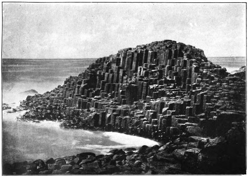
Nearly all countries of the world possess some of these curious springs, which cover with a calcareous crust any object placed in their waters. Among these incrusting springs, those of Saint Allyre, near Clermont, Rivoli, and San Filippo, not far from Rome, have justly become celebrated. These latter have, in a space of twenty years, filled up a pond with a bed of travertin 30 feet thick, and, in the neighborhood, entire strata of this same rock may be seen having a depth of more than 328 feet. The springs of Hammam-Mes-Khoutine, in the province of Constantine, are also very remarkable on account [597]of the considerable amount of their deposits. This water, which rises at a temperature of 203° (Fahr.), and from which a high column of steam always rises, is frequently compelled to change its point of issue on account of the dense beds of travertin which are gradually deposited upon the soil. Most of these deposits are of a dazzling white hue, striped here and there with bright colors, and are developed in mammillated strata; other concretions, accumulating gradually round an orifice, have taken the form of cones, and are like small craters near a volcano, some of them rising to a height of as much as 33 feet; lastly, there are masses of travertin which stretch out in a kind of wall below the flow which deposits them. One of these walls, which is interrupted at intervals by heaps of earth upon which large trees grow, is not less than 4,921 feet long, 66 feet high, and, on an average, from 33 to 49 feet wide.
The thermal waters of Algeria are, however, surpassed in grandeur and beauty by the springs of the ancient Ionian city of Hierapolis (holy city), which at the present time flow in the solitary plateau called Panbouk-Kelessi (Castle of Cotton), on account of the cotton-like aspect of the white masses of travertin of which it is composed. On reaching this spot from Smyrna, something like an immense cataract may be seen in the distance, 328 feet high and 2½ miles wide; this is formed by the walls which the water has gradually constructed, column after column, and layer after layer, by flowing over the edges of the plateau and gushing out on the slopes. Here and there, real cascades glitter in the sun, and their [598]sparkling surfaces light up the dead whiteness of the crystal walls. As a spectator ascends the declivities, the masses deposited and carved out by the water appear in all their strange beauty; one might fancy that they were colonnades, groups of figures, and rude bas-reliefs which the chisel had not yet perfectly set free from their rough coverings of stone. And all these calcareous deposits which have been fashioned by the cascades during a succession of ages open a multitude of cup-like hollows with fluted edges fringed with stalactites; these graceful reservoirs—some of which are shaded with yellow or veined with red, brown, and violet, like jasper or agate—are filled with pure water. Higher still follow two steps of the plateau on which stood the ancient thermal edifice and the Necropolis of Hierapolis. There whitish masses cover the ancient tombstones and fill up the conduits. The ground is crossed in various directions by the former beds of rivulets, which have gradually stopped up their own courses by depositing concretions upon them. Above one of the widest of these dried-up channels, the magnificent span of a natural bridge displays its graceful form, like an arch of alabaster, streaming with innumerable stalactites. At what date did this majestic structure take its rise, and how many years and centuries did the process of its formation last? No one knows. According to Strabo, the channels of the baths of Hierapolis were soon filled up by solid masses, and if Vitruvius can be believed, when the proprietors of the environs wished to inclose their domain, they caused a current of water to run along [599]the boundary-line, and in the space of a year the walls had risen.
Silica, which is still more important than chalk in the formation of terrestrial rocks, is also sometimes deposited on the edge of springs, but in very small quantities.
The various dislocations of the terrestrial strata, the cooling of the waters, and, perhaps, in many instances, the obstruction of channels by deposits of ore, explain why, in the present period, so small a number of thermal springs issue from metalliferous beds. Nevertheless, many localities might be mentioned where these phenomena take place at the present time. A spring at Badenweiler, in the Black Forest, issues forth at a few yards from a vein of sulphuret of lead. In the granitic plateau of central France other springs are likewise found to be associated with this metal. Various thermal waters in the Black Forest, like those of Carlsbad and Marienbad, are in close connection with veins of iron and manganese. Oligiste iron is found in the fissures of the springs of Plombières and Chaude-Fontaine. In Tuscany sulphureous fumaroles proceed from the veins of antimony. In France and Algeria the waters of Sylvanès and Hammam R’ira issue forth from beds of copper. Lastly, near Freyberg, a voluminous thermal spring has been discovered in a vein of silver.
Among the mineral substances which some springs bring to the surface of the soil, the most important, in an economical point of view, is common salt. This substance, being one of those which dissolve most [600]readily in water, all the liquid veins which pass over saline beds become saturated with salt; therefore springs of this kind, which flow in great abundance, give rise to salt-works of more or less importance. The masses of common salt which make their way every year from the interior of the earth may be estimated at thousands of tons. The springs of Halle, which rise on the northern slope of the Alps of Salzburg (Salt Town), and are managed with the greatest care, annually produce 15,000 tons of this mineral. The salt springs of Halle, in Prussia, which have been worked from time immemorial by a company, furnish 10,000 tons of salt every year. Other parts of Germany also yield for consumption thousands of tons of white salt, which is produced by the evaporation of saline springs. The mass of salt furnished by the single artesian well of Neusalzwerk, near Minden, in Prussia, represents every year a cube measuring 78 feet on each side.
Though not so rich as Germany in saline springs thus turned to account, most of the civilized countries of the world possess salt-works which are also very important. France enjoys the springs of Dieuze, Salins, and Salies; Switzerland, those of Bex; Italy has the springs in the environs of Modena, and many others besides. In England, near Chester, there are some mines of rock-salt in which numerous liquid veins issue forth which are impregnated with salt. Lastly, the United States have the celebrated springs of Syracuse.
Not far from the “spot where Troy once stood” is the valley of Touzla-sou, which owes its name (Salt [601]Water) to its numerous salt springs. The mountains which rise around its circumference are variously shaded with blue, red, and yellow, and the rocks are incessantly decomposing under the action of the liquid salt which oozes out from and trickles down their sides. The plain itself is covered with a variegated crust, while jets of boiling water, saturated with salt, burst forth in every direction. Here and there pools are found, the moisture of which, by evaporating in the sun, leaves upon the soil beds of salt as white as snow. Near the mouth of the valley springs become more and more numerous. Lastly, in the place where the cliffs approach near together, so as to form a defile, a magnificent spout of water jets out from one side of the rock. This jet is not less than a foot in diameter at the orifice, and falls again after having described a parabola of more than a yard and a half. Other springs shoot out on both sides, the constant temperature of which is more than 212° (Fahr.); these, together with the principal jet, form a rivulet of boiling and steaming water.
Springs of salt water are used for the treatment of diseases as well as for the extraction of salt. They constitute one of the most important groups of medicinal waters, according to the various substances which they contain in solution. The other springs made use of, on account of their healing virtues, have been classed under ferruginous, sulphureous, and acidulous springs. These waters also contain, in different proportions, a variable quantity of gases and salts which they have dissolved in their passage over subterranean beds of every kind.
[602]
Mineral springs are most numerous and abundant in mountain valleys, and there, consequently, the great thermal institutions are established. In Europe the chain of the Pyrenees is probably the richest in mineral, sulphureous, saline, ferruginous, and acidulous springs. According to Francis, the engineer, in 1860 more than 550 mineral springs, 187 of which are used, flowed upon the French slopes of the Pyrenees. These waters supplied 83 hot baths in 53 localities, the principal of which are Bagnères de Bigorre, Luchon, Eaux-Bonnes, and Cauterets. The most abundant springs, those of Graus d’Olette, form a sort of mineral stream, yielding more than four gallons a second, or 2,322 cubic yards a day. In Algeria the spring of Hammam-Mes Khoutine yields 6 gallons a second.
There are regions, some volcanic and some not, in which nearly all the springs are thermal and mineral; springs of pure and fresh water being so rare, they are there considered to be most precious treasures. One of these regions comprehends a large part of the plateau of Utah. In this place numerous thermal springs issue forth, to which have been given the vulgar names of the Beer, Steamboat, Whistle Springs, etc., and into one of which the Mormons plunge their neophytes. The springs which are not thermal are loaded with saline and calcareous matter. It is only in spring, at the time when the snow melts, that the springs, which then become very abundant, yield comparatively pure water. During the dry season, salt and carbonate of lime become concentrated in the nearly exhausted springs, and give to the [603]liquid flow an unpalatable taste. Palgrave, the traveler, informs us that all the springs of the country of Hasa, in Arabia, are also thermal.
It can readily be understood that when all these substances escape from the interior of the rocks, together with the water which holds them in solution, they must leave empty spaces in the earth. During the course of long centuries whole strata are dissolved, and, under a form more or less chemically modified, are brought up from the depths and distributed on the surface of the soil. The thermal waters of Bath, which are far from being remarkable for the proportion of mineral substances they contain, bring to the surface of the earth an annual amount of sulphates of lime and soda, and chlorides of sodium and magnesium, the cubic mass of which is not less than 554 cubic yards. It has also been calculated that one of the springs of Louèche, that of Saint Laurent, brings every year to the surface 8,822,400 pounds of gypsum, or about 2,122 cubic yards; this quantity is enough to lower a bed of gypsum a square mile in extent, more than five feet in one century. But this is only one spring, and we have reckoned one century only; if we think of the thousands of mineral springs which gush from the soil, and of the immensity of time during which their waters have flowed, some idea may be formed of the importance of the alterations caused by springs. In time they lower the whole mass of mountains, and, no doubt, after these sinkings, violent oscillations of the earth may often have taken place.
In regions where the strata are pierced with wide [604]and deep caverns, and especially in calcareous countries, the waters sometimes accumulate in sufficient quantities to form perfect streams with long subterranean courses. At their issue from the caverns, these waters form a contrast with the rocks and hills around, all the more striking because the latter are completely devoid of moisture, and fearfully sterile, while on the brink of the limpid stream the fresh verdure of plants and trees is at once developed. Like a captive, joyous at seeing the light once more, the water which shoots forth from the sombre grotto of rocks sparkles in the sun, and careers along with a light murmur between its flowery banks.
Among these subterranean streams, the most celebrated, and doubtless one of the most beautiful, is the Sorgues of Vaucluse. The vaulted grotto from which the mighty mass of water escapes opens at the mouth of an amphitheatre of calcareous rocks with perpendicular sides. Above the spring rises a high white cliff, bearing on its summit a ruined tower of the Middle Ages; the rock is everywhere sterile and bare; there is nothing but a miserable fig-tree, clinging to the stone like a parasitical plant to the bark of a tree, which has plunged its roots into the fissure of the cave, and greedily absorbs with its leaves the moisture which floats like a mist above the cascades of the spring. After heavy rains, the liquid mass, which is then estimated at 26 or even 32 cubic yards a second, flows in a wide sheet high above the entrance to the cavern, which is then altogether inaccessible. When the waters are low, they flow bubbling across the barrier of rocky débris [605]which obstructs the entrance; at that time it is quite possible to penetrate under the arch, and to contemplate the vast basin in which the blue waters of the subterranean stream spread out before they leap into the open air. Soon after its issue from the cave and amphitheatre of Vaucluse, the Sorgues is divided into numerous irrigation channels, which spread fertility in the country over an area of more than 77 square miles. The subterranean course of the affluents which form the stream is not ascertained; but it is known that most of them commence 12 or 15 miles to the east, in the plateaus of Saint Christol and Lagarde, which are pierced all over with avens or chasms, into which the rain-water sinks and disappears.
In another part of France there is a second important subterranean stream, which is much less known but no less remarkable than that of Vaucluse; this is the Touvre of Angoulême, continuing the course of the Bandiat, the waters of which, like those of the Tardoire, are swallowed up in several abysses at distances varying from 3 to 7 miles to the east and northeast. The three principal springs of the Touvre flow slowly out of a deep cave, hollowed out at the base of an escarped cliff; another spring bubbles up in a basin of rock; the third emerges from a sort of boggy meadow intersected by drains. At the outlet of their subterranean courses these three enormous springs immediately form three streams, which reunite, leaving between them two long peninsulas of reeds and other aquatic plants. Below the junction, the Touvre, which is here more than 100 yards wide, [606]passes round a rugged hill, and, dividing into several branches, turns the numerous mill-wheels of the important gun-foundry of Ruelle; then, after a course of five miles, it flows into the Charente at a small distance above Angoulême. Among the hundreds and thousands of travelers whom steam annually conveys over the bridge of the Touvre, there are few who are aware of the curious nature of the source of the river of limpid water over which the train passes in its noisy career.
Omitting to mention the streams which accidentally pass under the strata of rocks during a small part of their course, or of the subterranean outlets of certain lakes, a multitude of other instances might be brought forward of masses of water, more or less abundant, which appear above ground after having traversed a considerable distance under the earth. Of this kind is the graceful spring of Nîmes, the blue transparent water of which, reflecting the foliage of pines and chestnut trees, glides in its gentle ripples over the semicircular steps of an old Roman staircase. Of this kind, too, is the spring of Vénéran, near Saintes: this spring, which was formerly sacred to the Goddess of Love, gushes from the ground in a gorge of rocks, and, passing through a mill, the wheel of which it turns, it suddenly disappears, being swallowed up in an abyss; thus it appears on the earth to work but for an instant.
Numbers of water-courses do not reappear on the surface of the soil after being swallowed up in the earth, but flow straight to the sea by means of subterranean channels. On nearly the [607]whole extent of the continental shores, and principally in localities where the coasts are of a calcareous nature, the outlets of submarine tributaries may be noticed, some of which are perfect rivers. Most of the springs of the department of Bouches du Rhone jet up from the bottom of the sea, but at various distances from the shore. One of them, that of Porte Miou, near Cassis, forms on the surface of the sea a considerable current, which drifts any floating bodies to a great distance. At Saint Nazaire, Ciotat, Cannes, San Remo, and Spezzia, other streams also issue from the midst of the salt waves, and attempts have even been made to measure approximately their discharge. M. Villeneuve-Flayosc estimates at 24 cubic yards a second the quantity of water discharged into the sea by all the hidden affluents of the Mediterranean between Nice and Genoa. Some of the submarine springs of Provence and Liguria proceed from enormous depths. The orifice of the spring of Cannes is 531 feet below the level of the sea; that of San Remo rises from a depth of 954 feet; lastly, at four miles to the south of Cape Saint Martin, between Monaco and Mentone, another stream of fresh water empties itself under a bed of salt water, near 2,296 feet deep.
The coasts of Algeria, Istria, Dalmatia, and the Herzegovina also present numerous instances of submarine streams; on the eastern shores of the Adriatic the traveler may even have the pleasure of contemplating the delta of a considerable river, the Trebintchitza, visible through the sea-water at the depth of a yard. The abundant springs of fresh water [608]which pour out into the open sea to the southwest of the Cuban port of Batabano are well known, since Humboldt described them, and it is observed that the lamantins, or sea-cows, which dread salt water, delight in frequenting these parts. Lastly, the Red Sea, which does not throughout its immense circumference receive a single permanent stream flowing on the surface of the ground, nevertheless receives some which spring from the bottom of its bed. The shores of the United States, the calcareous soil of which is probably pierced with caverns from the very centre of the continent, perhaps are the coasts which pour into the sea the most abundant subterranean rivers. Near the mouth of the stream of St. John, a submarine stream of perfectly pure water spouts in bubbles as far as one to two yards above the level of the sea. Off the Carolinas, and Florida, salt water has been known to change into brackish water under the influence of the sudden increase of its subterranean affluents. In the month of January, 1857, all that part of the sea which is adjacent to the southern point of Florida was the scene of an immense eruption of fresh water. Muddy and yellowish water furrowed the straits, and myriads of dead fish floated on the surface and accumulated on the shores. Even in the open sea the saltness diminished by one-half, and in some places the fishermen drew their drinking-water from the surface of the sea as if from a well. It is affirmed by all those who witnessed this remarkable inundation of the subterranean river that, during more than a month, it discharged at least as much water as the Mississippi itself, and spread [609]over all the strait, 31 miles wide, which separates Key West from Florida.
On the coasts of Yucatan, the fresh waters which take a subterranean course down to the sea do not appear to flow like rivers which have a narrow bed and attain considerable speed, but more in the form of a wide sheet of liquid with a nearly imperceptible current. Cenotes open here and there over the surface of the country; they are a kind of natural draining-well or hole, not very deep, into which the inhabitants descend to draw spring water. At Merida and in the environs the subterranean water is found at a depth of 26 to 30 feet; but the nearer we approach to the sea the thinner the layer of rock becomes which covers the liquid veins; on the seashore fresh water is found nearly on a level with the soil. The height of the veins varies several inches, according to the quantity of rain; but in every season the mass of water descending from the plateau of Yucatan is poured into the sea through innumerable outlets. Over a great extent of the shore of the peninsula, these hidden springs furnish collectively a mass sufficiently large to counterpoise the waters of the sea. Under the pressure of the marine current which runs along the coast, there is formed, between the open sea and the liquid mass which has made its way from the land, a littoral bank like those barriers which the waves construct before the mouths of rivers. This embankment, which protects the coasts of Yucatan like a breakwater, is not less than 171 miles long, and is cut through by the sea at two or three points. The channel, which stretches like a [610]wide river between the bank of alluvium and the Yucatan coast, is, not without reason, designated by the inhabitants by the name of stream or rio.
Among the remarkable phenomena which perhaps owe their existence to subterranean water-courses, we must mention the sudden or gradual appearance of those hillocks of clay (“mud-lumps”) which rise, to the great danger of navigators, either in the middle of the bar of the Mississippi, or in the immediate vicinity. Like small volcanoes of mud, the “mud-lumps” generally appear under the form of isolated cones, allowing a rill of dirty water to escape from their summits. Some of them are irregular on their surface, on which lateral orifices here and there show themselves, some in full activity, others abandoned by the springs which formerly gushed from them. The water of some “mud-lumps” is loaded with oxide of iron or carbonate of lime, which, with the agglutinated sands, form hard masses, having the consistence of perfect rocks. These hillocks vary both in their height and shape. The greater part remain hidden at the bottom of the water, and even their summits do not reach the level of the river or sea; others hardly raise their heads above the waves; the most considerable, however, rise to a height of 6, 9, or even 19 feet, and their base covers an area of several acres. The sudden way in which most of these water-volcanoes make their appearance, the anchors of vessels, and the remains of cargoes which have been found on their surface, their conical form, their terminal craters, and all the springs, “which seem to spout out as if from a subterranean sieve,” [611]indicate the existence of a subterranean force always at work to upheave this band of hillocks.
M. Thomassy is of opinion that the hillocks of these bars are the orifices of regular artesian wells naturally formed by a sheet of subterranean water descending from the plateaus of the interior and flowing below the Mississippi and the clayey levels of Louisiana. However this may be, the mode in which these mud hillocks are formed is well enough known to render it easy to clear them away from the mouths of the Mississippi and to protect the interests of navigation. When a cone of clay makes its appearance on the bar, a charge of powder is introduced into it and explodes it. Thus, in the year 1858, the southwest passage was cleared of a “mud-lump” which formed a considerable island; a single charge was sufficient to annihilate the whole. The island suddenly sunk; in its place a wide depression was formed, the circumference of which resembled that of a volcanic crater; at the same time an enormous quantity of hydrogen gas was discharged into the atmosphere.
Above the springs the course of subterranean rivulets is generally indicated by a series of chasms or natural wells, which disclose the stream beneath. The arches of caves not being always strong enough to support the weight of the superincumbent masses, they necessarily fall in some places, leaving above them other spaces into which the upper beds successively sink. The débris of the ruin is afterward cleared away by the water, or dissolved, atom by atom, by the carbonic acid contained in the stream, [612]and gradually all the loose rubbish is carried away. In this manner, above the subterranean rivulets, a kind of well is formed, which is designated in various countries by very different names.
By means of these natural gulfs it is possible to reach the subterranean streams, and to give some account of their system, which is exactly like that of rivulets and rivers flowing in the open air. These streams also have their cascades, their windings, and their islands; they also erode or cover with alluvium the rocks which compose their bed, and they are subject to all the fluctuations of high and low water. The only important difference which superficial waters and subterranean currents present in their phenomena is that these streams in some places fill the whole section of the cave, and are thus kept back by the upper sides, which compress the liquid mass. In fact, the spaces hollowed out by the waters in the interior of the earth are only in a few places formed into regular avenues, which might be compared to our railway tunnels. Where beds of hard stone oppose the flow of the rivulet, all it has done during the course of centuries has been to hew out one narrow aperture. This succession of widenings and contractions, similar to those of the valleys on the surface, forms a series of chambers, separated one from the other by partitions of rock. The water spreads widely in large cavities, then, contracting its stream, rushes through each defile as if through a sluice.
On account of these partitions, it is very difficult, or even impossible, to navigate the course of subterranean rivers to any considerable distance, even at the [613]time the water is low. When it is high, the liquid mass, detained by the partitions, rises to a very high level in the large interior cavities, and often reaches the roof above. Sometimes when, through the clefts of the rocks, a communication exists between the cave and some hollow above, the surplus water from the subterranean streams makes its appearance there. Thus the Recca, which flows beneath the adjacent plateau of Trieste, does not always find space enough to flow freely in its lower channels, and Schmidt has seen it ascend in the chasms of Trebich to a height of 341 feet. It may be understood that the pressure of such a column of water often shatters enormous pieces of rock, and thus modifies the course of underground streams.
When the water, impelled by force of gravitation, seeks a new bed in the cavernous depths of the earth, and disappears from its former channels, these are at first much easier of access than they formerly were; but ere long, in most caves, a new agent intervenes, which seeks to contract or even completely obstruct them. This agent is the snow-water, or rain, which percolates, drop by drop, through the enormous filter of the upper strata. In passing through the calcareous mass, each one of these drops dissolves a certain quantity of carbonate of lime, which is afterward set free on the arch or the sides of the cave. When the drop of water falls, it leaves attached to the stone a small ring of a whitish substance; this is the commencement of a stalactite. Another drop trickles down, and, trembling on this ring, lengthens it slightly by adding to its edges a thin circular deposit [614]of lime, and then falls. Thus drop succeeds drop in an infinite series, each depositing the particles of lime which it contains, and forming ultimately a number of frail tubes, round which the calcareous deposit slowly accumulates. But the water which drops from the stalactites has not yet lost all the lime which it held in solution; it still retains sufficient to enable it to elevate the stalagmites and all the mammillated concretions which roughen or cover the floor of the grotto. It is well known what fairy-like decorations some caverns owe to this continuous oozing through the vaults of their roofs. There are few sights in the world more astonishing than that of these subterranean galleries, with their dead-white columns, their innumerable pendants and multiform groups, like veiled statues, all yet unstained by the smoke of the visitor’s torch.
When the action of the water is not disturbed, the needles and other deposits of the calcareous sediment continue to increase with considerable regularity. In some cases each new layer which is added to the concretions may be studied as a kind of time-measurer, indicating the date when the running water abandoned the cave. At length, however, the soft concentric layers disappear, and are replaced by forms of a more or less crystalline character; for in every case where solid particles exist, subject to constant conditions of imbibition by water, crystals are readily produced. Sooner or later, the stalactites, increasing gradually in a downward direction, meet and unite with the needles rising from the surface of the ground, and, forming by their number [615]a kind of barrier, obstruct the narrower passages and close up the defiles separating the cavern into distinct chambers.
One of these Kentucky caves, called the “Mammoth Cave,” is the largest which is at present known. The whole of its extent has not been as yet fully explored, for it may be almost called a subterranean world, having a system of lakes and rivers, and a network of galleries and passages without number, which cross and recross one another, going down to an immense depth. From the chief entrance to the further recesses of the cave, the distance is reckoned to be not less than 9¼ miles, and the whole length of the two hundred alleys that have been traced out in this enormous labyrinth is 217 miles in extent. This “Mammoth Cave” once served as a retreat for savage tribes, for skeletons of men of an unknown race have been found buried in it under layers of stalactite.
The district which is the most remarkable among all the calcareous countries of Europe for its caves, its subterranean streams, and its abysses is unquestionably the region of the Carniolan and Istrian Alps, which extends to the east of the Adriatic, between Laibach and Fiume. The whole surface of the country, as in certain plateaus of the Jura in France, is everywhere pierced with deep boat-shaped cavities, at the bottom of which the water forms a kind of whirlpool, like the water flowing out of the hold of a stranded ship. Many mountains are penetrated in every direction with caverns and passages, just as if the whole rocky mass was nothing more than [616]an accumulation of cells. On one steep cliff-side may be noticed all kinds of perforations at different heights—arched portals and orifices of fantastic shape; on another there are numbers of springs of blue water gushing from the caves, or from the rocks heaped up at the foot of the cliff, and forming rivulets which disappear a little further on in the fissures of the ground, as if through the holes of a sieve. The whole surface of the plateaus, whether bare or covered with forests, is scattered over with wells, or funnel-shaped holes communicating with subterranean reservoirs.
One of the Istrian rivers, the subterranean course of which, although still unknown as regards a great number of points, has given rise to a most continuous course of investigations, is the celebrated Timavus (Timavo), which falls into the sea near Duino, about twelve miles to the north of Trieste. Virgil’s description no longer applies to the mouths of the Timavo; at present they do not reach the number of nine, because the extermination of the woods of the Carso has diminished the mass of the water, or the action of the stream and the alluvium of the delta have modified the form of the shore. But still it is a magnificent spectacle to see the outlet of the three principal torrents of water which rush foaming out of the heart of the rocks, and are navigable from their mouths to their very source. A river of this importance must certainly receive the drainage of a vast basin, and yet all the neighboring valleys seem perfectly devoid of rivulets, and their surface presents little else but the bare rock; in fact, the [617]whole of the rain and snow-water runs away through underground caverns.
The most remarkable network of caverns in this region of the Alps is that which spreads out from the southwest to the northeast across the Adelsberg group of mountains, between Fiume and Laibach. The principal cave is especially curious on account of its size, the variety of its calcareous concretions, and the torrent which runs roaring through it.
North of the town of Adelsberg the traveler passes along the base of a hill with steep and bare sides, bringing into view the sharp edges of its highly pitched calcareous beds. On the right the stream of the Poik winds peaceably in the valley; and then, its course being arrested by a headland, turning suddenly, it flows into the interior of the mountain through a kind of high portal, opening between two parallel beds of rocks. Unless the water in the stream is very low, it is impossible to follow it over the accumulation of rocks upon its bed; but on the right, at a height of a few yards, there is another entry, through which the traveler may descend dry-shod into a vast cavity or chamber, where the Poik again appears issuing from its narrow passage of rocks.
At this point the cave divides; on the north the stream, the depth of which varies, according to the season, from a few inches to 30 or 33 feet, buries itself in a winding avenue, which has been traversed in a boat as far as a point 1,027 yards from the entrance; on the northeast, a higher avenue, discovered only in 1818, pushes its way far into the heart of the [618]mountain, branching out in various directions into narrow passages and wide compartments. This portion of the grotto, which appears to have been the former bed of the Poik, is the most curious part of the Adelsberg labyrinth; it affords wonderful groups of stalactites, especially in the Salle du Calvaire, the vaulted roof of which, having the enormous span of 210 yards, has dropped upon a hillock of débris a perfect forest of stalagmitic columns and white needles. The full length of the principal cave is not less than 2,575 yards; but very probably some other and still longer avenues may yet be discovered.
Although it is impossible to go in a boat along the subterranean portion of the Poik for a greater distance than 1,027 yards, by traversing the surface of the calcareous plateaus we can at all events trace out the subterranean stream by means of the funnel-shaped holes which open above its course. One of these gulfs, the Piuka-Jama, is situated about a mile and a half to the north of the entrance of the Adelsberg caves; the only way to descend into this is by clinging to the branches of the shrubs and sliding down by the assistance of a cord fastened to the top of the rocks. By these means the entrance to a kind of air-hole may be reached, from which the Poik is visible foaming over its bed of rocks, and only a slope of débris is to be descended to reach the edge of the stream. It can only be followed in the downstream direction for about 275 yards; but it can easily be ascended for a distance of 495 yards by passing under a high portal with lofty pillars, and in this way a point can be reached which is less than a [619]mile from the place where the stream disappeared in the cave of Adelsberg.
Further down the stream the Poik is not visible again until it emerges from the mountain, where it is known under the name of the Planina; it rushes out through a circular arch at the base of a perpendicular bluff crowned with fir-trees. It really is the Poik, as is proved by the equal temperature of water and the sudden increase of its liquid mass after a storm has burst at Adelsberg; but the stream always issues from the cave much more considerable in bulk than it is when it enters, owing to the tributaries which pour into it on both sides during its subterranean course of five to six miles. One of these rivulets, which comes down from the plateaus of Kaltenfeld, joins the Poik at a little distance from its outlet. Above the confluence the principal stream can be ascended in a boat to a distance of more than 3,500 yards, which, with the other explored parts of the subterranean river, makes about three miles. Below the point of outlet the stream is partially lost in the fissures of its bed, and then, joining the Unz, goes on and empties itself into the Danubian Save.
About a dozen miles to the southeast of the Adelsberg and Planina caves extends a large plain surrounded on all sides by high calcareous cliffs, at the base of which nestle seven villages. In this hollow, the most elevated portion of which is under cultivation, the remainder being covered with rushes and other marsh-plants, there are to be found more than 400 funnel-shaped holes resembling those in other parts of Carniola. These dolinas, the average [620]depth of which is from 40 to 60 feet, have each their special name, such as the “Grand Crible” (great sieve), the “Crible-à-froment” (corn sieve), the “Tambour” (drum), the “Cuve” (tub), the “Tonneau” (cask), pointing out the form or some remarkable peculiarity of each abyss. During extremely dry seasons there is only one of these cavities which contains any water; but after continuous and heavy rain, the water of a stream which is swallowed up in the rocks a little above the plain rises with a roaring noise in each of these wells. Torrents escaping from all these open “cribles” form in the wide space hemmed in by the cliffs a sea of blue and transparent water. This is the lake of Jessero or Zirknitz, the lacus Lugens of the Romans. The surface of the sheet of water extends over an area of 14,826 acres; at the time of great inundations, this extraordinary temporary lake, thus vomited out by the underground river, is not less than 24,711 acres. The water runs away through a subterranean channel, and, further on, empties itself into the Unz, below the Planina.
Lacustrine basins of this sort, first emitted, and then again absorbed by a subterranean water-course, are rather rare; there are, however, some other remarkable instances of them in Europe. Thus, in the Oriental Hartz, in the midst of a beautiful spot surrounded by fir-trees, the charming lake called Bauerngraben (Peasants’ Ditch), or sometimes Hungersee (Lake of Famine), sometimes makes its appearance; but when this mass of blue water has filled but for a few days its basin of gypsum rock, it is suddenly swallowed up, and flows away by subterranean channels [621]into the stream of the Helme. The celebrated lake of Copaïs, in Bœotia, may likewise be compared to the Zirknitz lake, at least as regards certain portions of its basin.
Rivers are the result of the natural tendency of water, as of all other bodies, to obey the law of gravitation by moving downward to the lowest position it can reach. The supply of water for the formation of rivers, though apparently derived from various sources, as from rain-clouds, springs, lakes, or from the melting of snow, is really due only to atmospheric precipitation; for springs are merely collections of rain-water; lakes are collections of rain or spring water in natural hollows, and snow is merely rain in a state of congelation. The rills issuing from springs and from surface-drainage unite during their downward course with other streams, forming rivulets; these, after a further course, unite to form rivers, which, receiving fresh accessions in their course from tributaries (subordinate rivers or rivulets) and their feeders (the tributaries of tributaries), sweep onward through ravines, and over precipices, or crawl with almost imperceptible motion across wide, flat plains, till they reach their lowest level in ocean, sea, or lake. The path of a river is called its course; the hollow channel along which it flows, its bed; and the tract of country from which it and its subordinates draw their supplies of water, its basin, or drainage-area. The basin of a river is [622]bounded by an elevated ridge, part of which is generally mountainous, the crest forming the watershed; and the size of the basin, and the altitude of its watershed, determine, cæteris paribus, the volume of the river. The greater or less degree of uniformity in the volume of a river in the course of a year is one of its chief physical features, and depends very much on the mode in which its supply of water is obtained.
In temperate regions, where the mountains do not reach the limit of perpetual snow, the rivers depend for their increase wholly on the rains, which, occurring frequently, and at no fixed periods, and discharging only comparatively small quantities of water at a time, preserve a moderate degree of uniformity in the volume of the rivers—a uniformity which is aided by the circumstance that in these ones only about one-third of the rainfall finds its way directly over the surface to the rivers; the remaining two-thirds sinking into the ground, and finding its way to spring-reservoirs, or gradually oozing through at a lower level in little rills which continue to flow till the saturated soil becomes drained of its surplus moisture, a process which continues for weeks, and helps greatly to maintain the volume of the river till the next rainfall. This process, it is evident, is only possible where the temperature is mild, the climate moist, evaporation small, and the soil sufficiently porous; and under these circumstances great fluctuations can only occur from long-continued and excessive rains or droughts. In the hotter tracts of the temperate zones, where little rain falls in summer, [623]we occasionally find small rivers and mountain torrents becoming completely exhausted; such is often the case in Spain, Italy, Greece, and with the Orange, one of the largest rivers of South Africa.
In tropical and semi-tropical countries, on the other hand, the year is divisible into one dry and one wet season; and in consequence the rivers have also a periodicity of rise and fall, the former taking place first near the source, and, on account of the great length of course of some of the tropical rivers, and the excessive evaporation to which they are subjected (which has necessarily most effect where the current is slow), not making itself felt in the lower part of their course till a considerable time afterward. Thus, the rise of the Nile occurs in Abyssinia in April, and is not observed at Cairo till about mid-summer. The fluctuations of this river were a subject of perpetual wonderment to the ancient civilized world, and were of course attributed to superhuman agency; but modern travel and investigation have not only laid bare the reason of this phenomenon, but discovered other instances of it, before which this one shrinks into insignificance.
The maximum rise of the Nile, which is about 40 feet, floods 2,100 square miles of ground; while that of the Orinoco, in Guiana, which is from 30 to 36 feet, lays 45,000 square miles of savannah under water; the Brahmaputra at flood covers the whole of Upper Assam to a depth of 10 feet, and the mighty Amazon converts a great portion of its 500,000 square miles of selvas into one extensive lake. But the fluctuations [624]in the rise of the flood-waters are surpassed by some of the comparatively small rivers of Australia, one of which, the Hawkesbury, has been known to rise 100 feet above its usual level. This, however, is owing to the river-beds being hemmed in by lofty abrupt cliffs, which resist the free passage of a swollen stream.
The increase from the melting of snow in summer most frequently occurs during the rainy season, so that it is somewhat difficult to determine, with anything like accuracy, the share of each in producing the floods; but in some rivers, as the Ganges and Brahmaputra, the increase from this cause is distinctly observable, as it occurs some time after the rains have commenced, while in the case of the Indus it is the principal source of flood. When the increase from melted snow does not occur during the rainy season, we have the phenomenon of flooding occurring twice a year, as in the case of the Tigris, Euphrates, Mississippi, and others; but in most of these cases the grand flood is that due to the melting of the snow or ice about the source.
The advantages of this periodical flooding in bringing down abundance of rich fertile silt—the Nile bringing down, it is said, no less than 140 millions of tons, and the Irrawadi 110 millions of tons annually—are too well known to need exposition here. Islands are thus frequently formed, especially at a river’s mouth. Permanent and capacious lakes in a river’s course have a modifying effect owing to their acting as reservoirs, as is seen in the St. Lawrence; while the Red River (North) and others in [625]the same tract inundate the districts surrounding their banks for miles. In tropical countries, owing to the powerful action of the sun, all rivers whose source is in the regions of perpetual snow experience a daily augmentation of their volume; while some in Peru and Chili, being fed only by snow-water, are dried up regularly during the night.
The course of a river is necessarily the line of lowest level from its starting-point, and as most rivers have their sources high up a mountain slope the velocity of their current is much greater at the commencement. The courses of rivers seem to be partially regulated by geological conditions of the country, as in the case of the San Francisco of Brazil, which forms with the most perfect accuracy the boundary-line between the granitic and the tertiary and alluvial formations in that country; and many instances are known of rivers changing their course from the action of earthquakes, as well as from the silting up of the old bed. The inclination of a river’s course is also connected with the geological character of the country; in primary and transition formations, the streams are bold and rapid, with deep channels, frequent waterfalls and rapids, and pure waters, while secondary and alluvial districts present slow and powerful currents, sloping banks, winding courses, and tinted waters; the incline of a river is, however, in general very gentle—the average inclination of the Amazon throughout its whole course being estimated at little more than six inches per mile, that of the Lower Nile less than seven inches, and of the Lower Ganges about four inches per mile.
[626]
The average slope of the Mississippi throughout its whole length is more than seventeen inches per mile, while the Rhone is, with the exception of some much smaller rivers and torrents, the most rapid river in the world, its fall from Geneva to Lyons being eighty inches per mile, and thirty-two inches from Lyons to its mouth.
The velocity of rivers does not depend wholly on their slope; much is owing to their depth and volume (the latter being fully proved by the fact that the beds of many rivers remain unaltered in size and slope after their streams have received considerable accessions, owing to the greater rapidity with which the water runs off); while bends in the course, jutting peaks of rock or other obstacles, whether at the sides or bottom, and even the friction of the aqueous particles, which, though slight, is productive of perceptible effect, are retarding agencies. In consequence, the water of a river flows with different velocities at different parts of its bed; it moves slower at the bottom than at the surface, and at the sides than the middle. The line of quickest velocity is the line drawn along the centre of the current, and in cases where this line is free from sudden bends or sharp turns, it also represents the deepest part of the channel. The average velocity of a river may be estimated approximately by finding the surface-velocity in the centre of the current by means of a float which swims just below the surface, and taking four-fifths of this quantity as a mean. If the mean velocity in feet per minute be multiplied by the area of the transverse section of the stream in square feet, the [627]product is the amount of water discharged in cubic feet per minute. According to Sir Charles Lyell, a velocity of 40 feet per minute will sweep along coarse sand; one of 60 feet, fine gravel; one of 120 feet, rounded pebbles; one of 180 feet (a little more than two miles per hour), angular stones the size of an egg.
“Rivers are the irrigators of the earth’s surface, adding alike to the beauty of the landscape and the fertility of the soil; they carry off impurities and every sort of waste débris; and when of sufficient volume, they form the most available of all channels of communication with the interior of continents.... They have ever been things of vitality and beauty to the poet, silent monitors to the moralist, and agents of comfort and civilization to all mankind.” By far the greater portion of them find their way to the ocean, either directly or by means of semi-lacustrine seas; but others, as the Volga, Sir-Daria (Jaxartes), Amu-Daria (Oxus), and Kur (Araxes), pour their waters into inland seas; while many in the interior of Asia and Africa—as the Murghab in Turkestan, and the Gir in the south of Morocco—“lose themselves in the sands,” partly, doubtless, owing to the porous nature of their bed, but much more to the excessive evaporation which goes on in those regions.
[628]
Marshes proper are shallow lakes, the waters of which are either stagnant or actuated by a very feeble current; they are, at least in the temperate zone, filled with rushes, reeds, and sedge, and are often bordered by trees, which love to plunge their roots into the muddy soil. In the tropical zone a large number of marshes are completely hidden by multitudes of plants or forests of trees, between the crowded trunks of which the black and stagnant water can only here and there be seen. Marshes of this kind are inaccessible to travelers, except where some deep channel, winding in the midst of the chaos of verdure, allows boats to attempt a passage between the water-lilies, or under some avenue of great trees with their long garlands of creepers waving in the shade. Whatever may be the climate, it would, however, be impossible to draw any distinction, even the most vague, between lakes and marshes, as the level of these sheets of water oscillates according to the seasons and years, and as the greater number of lakes, principally those of the plains, terminate in shallow bays which are perfect marshes. Some very important lacustral basins, among others Lake Tchad, one of the most considerable in all Africa, are entirely surrounded by swamps and inundated ground, which prohibit access to the lake itself, and prevent its true dimensions from being known.
[629]
In like manner, a portion of the course of many rivers traverses low regions in which marshes are formed, either temporary or permanent, the uncertain limits of which change incessantly with the level of the current. The borders of great water-courses, when left in their natural state, are the localities in which these marshy reservoirs principally exist. The most remarkable marshes of this kind are perhaps those crossed by the Paraguay and several of its tributaries; they consist of wet prairies and interminable sheets of water, which stretch away like a sea from one horizon to the other. They have received the names of Lakes Xarayes, Pantanal, etc. Further south, certain tributaries of the Parana, the Maloya, the Batel, and the Sarandi, which cross the State of Corrientes from northeast to southwest, are nothing but wide marshes, the water of which overflows slowly across the grass on the imperceptible slope of the territory. There is, indeed, one of these marshes, the Laguna Bera, which drains simultaneously into the two great rivers of Parana and Uruguay.
In the same way as the low river-shores are frequently converted into marshes, vast extents of the seacoasts when but slightly inclined are also covered over by marshes, which are generally separated from the main sea by tongues of sand gradually thrown up by the waves. In these marshes, most of which once formed a part of the sea and still mark its ancient outline, the water presents the most varied proportions of saline admixture. These half dried-up bays are rarely deep enough to allow of large vessels sailing in them, and their banks are generally overrun by [630]the most luxuriant vegetation. The shore constantly keeps gaining upon them, and thus tends to the increase of the mainland.
The coasts which surround the Caribbean Sea and the Gulf of Mexico, and also the Atlantic shores of North America from the point of Florida to the mouth of the Chesapeake, are bordered by a very large number of marine marshes, forming a continued series over hundreds and thousands of miles in length. In this immense series of coast-marshes all kinds of vegetation seem to flourish, and threaten to get the better of the mud and water, and to convert them into terra firma. To the south, upon the shores of Colombia and Central America, the mangroves and other trees of like species plunge the terminal points of their aerial roots deep into the mud, crossing and recrossing in an arch-like form, and retaining all the débris of plants and animals under the inextricable network of their natural scaffoldings. The shores of the Gulf of Mexico, in Louisiana, Georgia, and Florida, are bordered by cypress swamps, or forests of cypress (Cupressus disticha); these strange trees, the roots of which, entirely buried, throw out above the layer of water which covers the soil multitudes of little cones, the business of which is to absorb the air. For millions of acres nearly all the marshy belt along the seashore is nothing but an immense cypress swamp, with trees bare of leaves, and fluttering in the wind their long hair-like fibres of moss. Here and there the trees and muddy soil give place to bays, lakes, or quaking-meadows, formed by a carpet of grass lying upon a [631]soil of wet mud, or even upon the hidden water. In Brazil these buoyant beds of vegetation are frequently met with, and the significant name of tremendal has been given to them: in Ireland these are called “quaking-bogs.” The least movement of the traveler who ventures upon them makes the soil tremble to some yards’ distance.
To the north of Florida, in the Carolinas and Virginia, the belt of cypress swamps continues; but in consequence of the change of climate and vegetation, the quaking-meadows are gradually converted into peat-mosses. The surface of the marsh is incessantly renewed by a carpet of green vegetation, while below, the dead plants, deprived of air, carbonize slowly in the moisture which surrounds them: these are the beds of peat which form upon the ground just as the layers of coal were formed in previous geological epochs.
On the southern side, the first great peat-bog of a well-defined character is the “Dismal Swamp,” which extends along the frontiers of North Carolina and Virginia. This spongy mass of vegetation rises ten feet above the surrounding land. In the centre, and, so to speak, upon the summit of the marsh, lies Lake Drummond, the clear water of which is colored reddish-brown by the tannin of the plants. A canal, which crosses the Dismal Swamp to connect it with the adjacent streams, is obliged to make its way along the marsh by means of locks. To the north of Virginia peat-bogs proper become more and more numerous; and in Canada, Labrador, etc., they cover vast expanses of country. All the interior of the [632]island of Newfoundland, inside the inclosure formed by the forests on the shore, is nothing but a labyrinth—a great part of which is still unknown—of lakes and peat-bogs; even on the sides of the hills there are marshes on so steep an incline that the water from them would disappear and run off in a stream if it was not stopped by the thick carpet of plants which it saturates. Many a large peat-bog which may be crossed dry-shod contains more water than many lakes filling a hollow of the valley with deep water.
Opposite Newfoundland, on the other side of the Atlantic, Ireland is hardly less remarkable for the enormous development of its peat-mosses or bogs. These tracts of saturated vegetation, in which Sphagnum palustre predominates, comprehend nearly two and a half millions of acres—the seventh part of the whole island. The inhabitants continue to extract from them, every year, immense quantities of fuel. The spaces left by the spade in the vegetable mass are gradually filled up again by new layers. After a certain number of years, which vary according to the abundance of rain, the depth of the bed of water, the force of vegetation, and the slope of the soil, the turf “quarry” is formed anew. In Ireland it generally takes about ten years to entirely fill up again the trenches, measuring from nine to thirteen feet in depth, which are made in the bogs on the plains, when a fresh digging of turf may be commenced. In Holland, crops of this fuel may be gathered, on an average, every thirty years. In other peat-moss districts the period of regeneration last forty, fifty, [633]and even a hundred years. In France, on the borders of the Seugne (Charente-Inférieure), it has been ascertained that ditches five feet deep and nearly seven feet wide are completely obstructed by vegetation after the lapse of twenty years. As for the beds of peat which carpet the sides of mountains, they take centuries to form afresh.
In Ireland, the Low Countries, the north of Germany and Russia, heaps of trunks of former forest-trees—oaks, beech, alder, and other trees—are frequently discovered, which by their decay have made way for the peat-mosses. The Sphagnum, too, often takes possession of ground of which man had previously made himself master, and in many places roads, remains of buildings, and other vestiges of human labor are found below the modern bed of vegetation by which they are now covered. Certain peat-bogs in Denmark and Sweden may be considered, on account of the curiosities which have been found in them, as perfect natural museums, in which the relics of the civilization of ancient nations have been preserved for the savants of our own day.
The air above the peat-mosses of Ireland and other countries in the world is not often unhealthy, either because the heat is not sufficient to develop miasma, or else because the vegetation, by absorbing the water into its spongy mass, impedes the corruption of the liquid, and produces a considerable quantity of oxygen. Further south, the peat-mosses, which are intermixed with pools of stagnant water, and especially marshes properly so-called, generate an impure air, which spreads fever and death over the surrounding [634]country. Unless marshes are surrounded with dense forests, which arrest the dispersion of the gases, the latter exercise a most injurious influence on the general salubrity of the district; for during dry weather, a vast area of the bed of the marshes becomes exposed, and the heaps of organic débris lying on the bottom decompose in the heat and infect the whole atmosphere. The average of life is much shorter in all marshy countries than in the adjacent regions which are invigorated by running water. In Brescia, Poland, in the marshes of Tuscany, and in the Roman plains, the wan and livid complexion of the inhabitants, their hollow eyes, and their feverish skin, announce at first sight the vicinity of some centre of infection. There are some marshes in the torrid zone where the decomposition of organic remains goes on with a much greater rapidity than in temperate climates; no one can venture on the edges of these districts without peril to his life. As Frœbel ascertained in his journey across Central America, the miasma is occasionally produced in such abundance that not only can it be smelt, but a distinct impression of it is left upon the palate.
The plateaus and mountain regions of the globe occupy a large portion of its surface—perhaps more than half of the whole extent of the land—and their influence over its climate and other natural conditions affecting mankind is very great. The highlands [635]of the Old World—fitted by their physical attributes to be the home of pastoral and nomad races—were among the regions earliest occupied by mankind. From the banks of the Euphrates and the primeval cities of the Assyrian plain, the course of the shepherd-warrior—whether directed to the east or the west—led toward some of the elevated regions which stretched thence within the same (or nearly the same) degrees of latitude, and which, at least in a general sense, are under like conditions of climate. The highlands of Persia and Afghanistan, in the one direction, of Syria and the Lesser Asia, in the other, display abundant evidence, both in traditional and monumental records, of their early occupation by man. From the one, the natural order of advance leads to the fertile plains of India; from the other, to the shores of the Mediterranean, whence is easy transit to the peninsula and islands that lie beyond.
But if the highlands of the earth were early the dwelling-place of the shepherd-warrior, it was within the adjoining lowland plains and fertile river basins that the arts of civilization were first called into being, that towns were built, that population became numerous, and that systems of social polity were developed. The lowland plains of Asia and Europe constitute, in the present day, the most populous regions of the globe, and include by far the more numerous portion of the human race. The like regions in the New World are fast filling with inhabitants, as the redundant population of older lands is directed, in an ever-flowing stream, across the waters of the Atlantic.
[636]
The most important and extensive among the lowland plains of the Old World are the following:
In Asia.—Plain of the Euphrates and Tigris (the ancient Mesopotamia and Babylonia); Plain of Hindustan, or Northern India; Plain of China, embracing the northeast part of that country; Plain of Siberia; Plain of Turkestan. Among lowland regions of less importance are the plains of Pegu, Siam, and Tonquin, all within the Indo-Chinese peninsula, or India beyond the Ganges.
In Europe.—The Great Eastern Plain, embracing nearly the whole of Russia; Plain of Hungary, embracing the middle portion of the valley of the Danube; Plain of Wallachia and Bulgaria, or the Lower Danube; Plain of Lombardy, or Northern Italy; Plain of Languedoc, in the south of France; Plain of Andalusia, in the south of Spain; Plain of Bohemia, or basin of the Upper Elbe.
The limits and direction of these regions may be traced upon any ordinary map, by means of their coincidence with the great river basins of the Eastern Hemisphere. They include the longer slopes of the land, which are directed toward the north and northwest, as well as the less extensive low grounds which border the Indian and Pacific Oceans. The Siberian plain alone comprehends an area equal to that of Europe, and the rivers by which it is watered are among the most considerable in the Old World. So vast an area, under other conditions of climate, might have become the home of populous nations, the seat of civilization and empire. But its high latitudes, which involve the rigor of an Arctic sky, condemn a [637]large portion of Siberia to the condition of a sterile wilderness, and must prevent even its more favored districts from being other than thinly inhabited. The dreary swamps and morasses of the tundras, which replace, during the brief summer of those latitudes, the plain of ice and snow, stretch along the shores of the Arctic Sea through a vast extent of this widespread region.
Conditions hardly more favorable belong to the extreme northern portion of the great plain of Europe, the slope of which is directed toward the White Sea and the Arctic basin. But a large portion of Eastern Europe is inclined toward a southerly sky, and is watered by rivers which have their outfall into the Black and Caspian Seas. The Volga, the longest of European rivers, belongs to the Caspian basin, the most depressed portion of the entire region.
The southeastern division of the European lowland, and the adjacent portions of Asia, constitute the region of the steppes. These occupy an immense portion of the empire of Russia, and are among the most characteristic of the physical features of the Old World. The steppes are grassy plains—prairies, or meadows, they would be called in the New World—which occupy a vast belt of the European and Asiatic continents. They stretch eastward from the banks of the Dnieper far into the heart of Asia—along the shores of the Caspian and Aral Seas, and as far as the banks of the great river Obi. Indeed, in so far as their grassy covering and general level expanse—among the prime characteristics of the steppe-land—are [638]concerned, a like region may be said to extend to the eastward through Central Asia, as far as the Great Wall of China and the valley of the Amour. This is the “land of grass” of the Mongol shepherd, the true home of the Tartar nations, whose descendants yet preserve in their songs the memory of their famous leader Timour—the Tamerlane of historic record. So vast is the extent of this grass-covered region, that a mounted horseman, it has been said, setting out from one of its extremities at the beginning of the year, and traveling day and night at his utmost speed, would find the season of spring elapse ere he reached its further limits.
The southwestern portion only of the steppe-land falls within the limits of Europe. This exhibits an unbroken expanse of level plain—fatiguing to the eye from its perfect uniformity—dry and burned up by excessive heat in summer, a pathless expanse of snow during the opposite season of the year. The steppe is only productive during the brief time that the thirsty soil is refreshed by the rains of spring and early summer. Its aspect is then, for a time, glowing and verdant; grass and wild flowers cover the earth with a carpet of varied and attractive hues, and the wild cattle and horses luxuriate in the abundant pasture. In the autumn, when the herbage has become dry and withered, the steppe sometimes exhibits a vast sheet of rolling flame, the grass being occasionally fired by accident, at other times intentionally, for the sake of the young crop which springs up through the ashes. The illusive phenomena of mirage—the result of atmospheric refraction, engendered [639]by the intense dryness of the air—are of frequent occurrence in the steppe. Sometimes the eye is cheated by the semblage of a lake, which vanishes on approach. In other instances, the traveler over these wild regions appears to see rising before him, and glittering through the dense mist which often prevails during the hours of midday heat, the towers and other buildings of a distant city. Spires, trees, bridges, rivers, all appear in picturesque combination, only to sink into confusion as they are approached. When the spot where the city of enchantment had seemed to stand is actually reached, there is found only the long, dry grass, waving as elsewhere in the surrounding waste. The vast accumulation of dry sand on the surface gives rise to another phenomenon, of frequent occurrence on the steppe, resembling waterspouts upon the sea, excepting that the column is filled with dust instead of water. “Suppose the great flat steppe stretched out beneath the blue sky—nothing visible—no breath of air apparently stirring—the whole plain an embodiment of sultriness, silence, and calmness—when gradually rise in the distance six or eight columns of dust, like inverted cones, two or three hundred feet high, gliding and gliding along the plain in solemn company; they approach, they pass, and vanish again in the distance, like huge genii on some preternatural errand.”
Such is the region over which the semi-nomad tribes of Tartar shepherds, who constitute a fraction of the vast population of the Russian Empire, pasture their herds. It is only here, within the limits of Europe, that the camel is successfully reared. [640]Odessa, the great outport of southern Russia, stands almost on the edge of the steppe, and the whirlwinds of dust that pass through its streets, and constitute, during a portion of the year, one of its chief drawbacks as a place of residence, furnish obvious evidence of this proximity. The steppe includes two-thirds of the Crimean peninsula, the extreme south of which, however, is traversed by a hill-range of considerable elevation, and exhibits widely different features.
Beyond the Dnieper, the Don, and even the Volga, the same region of alternate grassy plain and sandy waste stretches far into the Asiatic continent. To the east and north of the Caspian and the Aral are the steppes over which roam the hordes of the Khirghiz. The names of Kara-kum and Kizil-kum, given respectively to the sandy wastes which extend upon either side of the river Syr, or Jaxartes, are strikingly indicative of the general character of the tracts to which they are applied.
Mr. T. W. Atkinson, in his Travels in Regions on the Upper and Lower Amour, thus describes the journey through these wild regions: “For many miles the sand was hard, like a floor, over which we pushed on at a rapid pace. After this we found it soft in places, and raised into thousands of little mounds by the wind. Our horses were now changed, and in an hour these mounds were passed, when we were again on a good surface, riding hard.... Hour after hour went by, and our steeds had been changed a second time.... In our route there was no change visible—it was still the same plain; there [641]was not so much as a cloud floating in the air, that, by casting a shadow over the steppe, could give a slight variation to the scene.... The whole horizon was swept with my glass, but neither man, animal, nor bird could be seen.... We rode on for several hours, but there was no change of scene. One spot was so like another that we seemed to make no progress.... No landmark was visible, no rock protruded through the sterile soil; neither thorny shrub nor flowering plant appeared, to indicate the approach to a habitable region; all around was ‘kizil-kum’ (red sand).”
The perfect solitude and unbroken silence of the desert are not less characteristic than its wearisome monotony of surface. No sound of bird or animal breaks the solemn stillness which reigns around; no trees expose their foliage to the influence of the wind. The course of the traveler is still onward, through the same apparently interminable waste. “Fourteen hours had passed, and still a desert was before us. The sun was just sinking below the horizon. The Kirghiz assured me that two hours more would take us to pastures and to water.... It had now become quite dark, and the stars were shining brilliantly in the deep blue vault. My guides altered their course, going more to the south. On inquiring why they made this change, one of them pointed to a star, intimating that by that they must direct their course.
“We traveled onward, sometimes glancing at the planets above, and then anxiously scanning the gloom around, in the hope of discovering the fire of some [642]dwelling that would furnish food and water for our animals. Having ridden on in this manner for many miles, one of our men stopped suddenly, sprang from his horse, and discovered that we had reached vegetation. The horses became more lively and increased their speed, by which the Kirghiz knew that water was not far off. In less than half an hour they plunged with us into a stream, and eagerly began to quench their terrible thirst, after their long and toilsome journey.”
The features above described are those of the steppe region, regarded as a whole. But this aspect undergoes considerable variation in particular localities. The Lower Steppes, as those portions of the great plains which immediately border the Caspian are termed, exhibit a soil largely impregnated with saline particles, and contain numerous salt-water lakes. Some of these lakes furnish a large quantity of salt, derived by means of evaporation. This region resembles in aspect the dried-up bed of a sea. The Caspian, upon which it borders, occupies the lowest part of a depression below the general level of the earth’s surface, its waters being 81 feet lower than those of the Black Sea. The extent of the Caspian appears to be gradually diminishing.
The features of the steppe-land, however, are exceptional to the general characteristics of the European plain, regarded as a whole. Large portions of its middle and western divisions possess a rich arable soil, and exhibit annually a waving sea of corn. The geographical limits of the lowland region are marked, in the direction of north and south, by the [643]Black Sea and the Arctic Ocean. The eastwardly portions of this vast level expanse stretch into the heart of Asia. In the west it reaches the shores of the Baltic, and is thence prolonged, with narrower dimensions, through northern Germany and the low flats of Holland, until it subsides beneath the water of the German Ocean. Throughout this vast extent, tertiary and recent formations prevail, and the abundant clays, sands, and gravels give their character to the surface-soil. The plain lying to the south of the Baltic consists principally of sandy heaths, and contains, toward the seashore, a vast number of small lakes or meers.
The low shores of Holland—conquered from the sea by the persevering industry of the Dutch nation—furnish a conspicuous example of the sand-hills, or dunes, which are often found on low sandy coasts, and which owe their origin to the action of prevailing winds upon the loose drift-sand. Where no means are adopted to fix them to the soil, the sand-hills become agents of destruction, sometimes overwhelming whole villages in their slow but steady advance inland. But this is not the case in Holland, where the ingenuity of the Dutch has converted them from instruments of destruction into a means of national preservation. In some of the provinces of the Netherlands, a large portion of the land is actually lower than the level of high-water mark, and is therefore exposed (it might appear) to the ravages of the adjoining ocean. But from the channel of the Helder southward, the coast is protected by a line of broad dunes, or sand-hills, which are partially covered [644]with grass or heath, and are in some places from forty to fifty feet in height. These have been formed by the natural process above adverted to, and still in operation; the prevalent sea-winds raise banks or ridges of sand at a short distance from the coast, which the inhabitants prevent from proceeding further inland by sowing them with a kind of grass (arundo arenaria), the long roots of which bind the whole mass firmly together.
The district of the Landes, in the southwest corner of France, offers an example of the combined action of sand and sea which is widely different from the above in its results. The coast here exhibits a line of shifting sand, backed toward the interior by a belt of pine-forest. For a length of nearly two hundred miles, from the mouth of the Garonne to that of the Adour, there stretches along the extreme edge of the sea a range of hills composed of white sand, as fine as though it had been sifted for an hour-glass. Every gale changes the shape of these rolling masses of drift-sand. A strong wind from the land flings millions of tons of sand per hour into the sea, to be again washed up by the surf, flung upon the beach, and with the first Biscay gale blown in whirlwinds inland. A water hurricane from the west has been known to fill up with sand many square miles of shallow lake, driving the displaced waters inland, dispersing them among the pine-woods, flooding and frequently destroying the scattered hamlets of the people, and burying forever their fields of millet and rye. The shepherds of the Landes pursue their avocation mounted upon stilts, which raise them above [645]the reach of the sand-blasts. The pine-forests yield annually a large supply of resin, the only harvest of this wild region. Intermixed with the pine-forests, a chain of shallow and marshy lakes stretches in a direction parallel to the coast, and at a few miles inland.
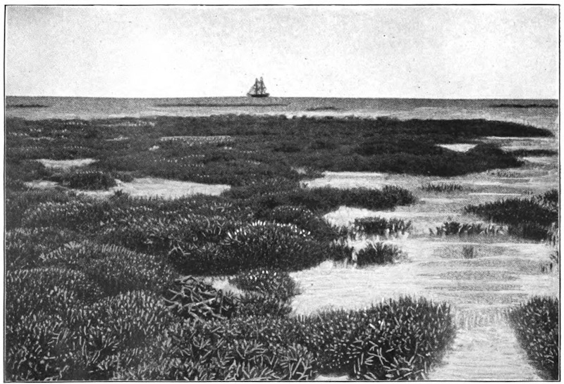
The lowland plains of the New World are on a scale of vast magnitude, and, if not superior in extent to those of the Eastern Hemisphere, yet bear a much larger proportion to the entire area of the land. They are watered, moreover, by the longest rivers of the globe, and enjoy, for the most part, conditions of situation and climate in the highest degree favorable to man. Both in North and South America, the whole central expanse of the continent exhibits a vast succession of lowland plains, the only division between the different portions of which is that formed by the watersheds of its longer rivers—not always to be traced without difficulty, owing to the generally level nature of the entire plain. In North America, the prairies; in South America, the tracts known as llanos, selvas, and pampas, are included within the lowland region, and exhibit some of the most characteristic among the aspects of nature in the Western world.
The prairies coincide, in a general sense, with the middle and upper portion of the Mississippi Valley, embracing the vast region which extends from the Great Lakes to the base of the Rocky Mountains. They are covered in their natural state with a rich herbage, and exhibit a waving sea of grass several feet high. At intervals, toward the banks of the [646]rivers, patches of forest vegetation break the uniformity of the prospect, but the prairie itself is destitute of trees, and (as the name implies) is merely a grassy plain, or meadow. Alternate forest and prairie constitute the great features of natural scenery in the New World. When the rich soil of the prairie-land is broken up by the plow—an operation which is rapidly progressing, year by year, within the Western States of America—it yields abundant crops of corn. There are, however, within the vast extent of the North American continent, immense regions which yet retain the aspect of the wilderness. It was within these regions that the buffalo roamed, in vast herds, and that the native Indian hunter pursued his game ere the advancing footsteps of the white man had driven him from his haunts.
The llanos, or savannahs, are vast grassy plains, which occupy nearly the whole basin of the Orinoco River, excepting only toward its highest portion, when they are succeeded by wooded plains. The llanos resemble in general features the prairies of the Mississippi Valley, but have for the most part a lower level, and (owing to the abundant rains of the torrid zone) are annually inundated by the rivers to an immense extent. Whole districts, embracing thousands of square miles, are annually converted, within the interior plains of South America, into lakes, or temporary seas of fresh water, to be rapidly evaporated under the burning rays of a vertical sun. At the close of the rainy season the llanos are covered with grass, and form rich natural pasture-grounds. During the prolonged season of drought which ensues, [647]the verdure is entirely destroyed, and the parched earth opens in wide and deep crevices—again to be laid under water with the recommencement of the rains.
The selvas, or forest-plains, belong to the valley of the Amazon, and include an immense area of Brazil, watered by the lower portion of the great stream and its chief tributary, the Madera. Vast regions are here covered by an uninterrupted forest, composed of trees of giant growth, their boughs interlaced by immense creeping plants, and the ground beneath thickly covered with a dense growth of underwood. To the southward of the forest region are vast grassy plains, which stretch in that direction into the valley of the Paraguay.
The pampas, or plains of the Paraguay and Paraná valleys, exhibit the same luxuriant natural growth of herbaceous plants as other lowland regions of the New World. They include an immense region, which stretches from the neighborhood of the southern tropic far to the southward of the river Negro (lat. 39° S.), and from the banks of the Paraná to the eastern base of the Andes. The pampas are variously covered with long coarse grass, mixed with wild oats, clover, and other herbage. The tract of country known by the name of El Gran Chaco, immediately to the westward of the upper Paraguay—scarcely tenanted excepting by wild beasts—exhibits a luxuriant covering of grass, which springs from a soil possessed of the highest natural capabilities.
Further south, the plains that extend from Buenos Ayres to the foot of the Andes are covered, during a [648]great part of the year, with gigantic thistles, which grow to the height of seven or eight feet, and are so thick as to render the country almost impassable. For nine months of the year the thistles are here the predominant (and almost the sole) feature of the vegetable kingdom; but with the heats of summer they are burned up, and their tall leafless stems are leveled to the ground by the powerful blast of the pampero, or southwest wind, which blows from the snowy ranges of the Andes, after which the ground is covered for a brief season with herbage. This is destined, with the returning spring, again to give place to the stronger vegetation which it had succeeded, and for a time supplanted.
A bright fine evening after a day of rain is one of Nature’s compensations. The air is peculiarly sweet and fresh, as though the rain had washed all evil out of it. The mind, relieved from the depressing influence of continuous rain, is exhilarated, and, above all, the strong smell of the earth rises up with a scent more pleasing than many a fragrant essence. In the town, indeed, this earthy smell is often obscured by the bricks and mortar which cover the land, and by the stronger, less wholesome, odors of human life, but in the country it has full sway, and fills the whole air with its presence. Even a slight shower, particularly after drought, is [649]sufficient to bring out the sweet familiar smell of the land and thrust it upon our notice.
The smell of freshly turned earth is often regarded by country lovers as one of the panaceas for the ills of the flesh, and “follow a plowshare and you will find health at its tail” has proved a sound piece of advice to many a weakly town-sick one, over whose head the threatenings of consumption hung like the sword of Damocles, though it is possible that it is the fresh air, and more especially the sunshine, which are the saving media, and not the mere smell.
But what do we know about this characteristic smell of the soil? Can we regard it as the mere attribute of the soil as a simple substance, such an attribute as is, for instance, the peculiar smell of leather, or the odor of india-rubber; or can we go deeper and find that it is really an expression of complexity below?
Strangely enough this is the case, for the smell of damp earth is one of the latest sign-posts we have found which lead us into a world which, until recently, was altogether beyond our ken. It points us to the presence, in the ground beneath us, of large numbers of tiniest organisms, and not merely to their presence only, but to their activity and life, and reveals quite a new phase of this activity. A handful of loose earth picked up in a field by the hedgerow, or from a garden, no longer represents to us a mere conglomeration of particles of inorganic mineral matter, “simply that and nothing more”; we realize now that it is the home of myriads of the smallest possible members of the great kingdom of [650]plants, who are, in particular, members of the fungus family in that kingdom, plants so excessively minute that their very existence was undreamed of until a few years ago.
Some faint idea of their relative size, and of the numbers in which they inhabit the earth, may be gleaned from the calculations of an Italian, Signor A. Magiora, who, a short time ago, made a study of the question. He took samples of earth from different places round about Turin and examined them carefully. In ordinary cultivated agricultural soil he found there would be eleven millions of these germs in the small quantity of a gramme, a quantity whose smallness will be appreciated when it is remembered that a thousand grammes only make up about two and a quarter pounds of our English measure. Thus, a shovelful of earth would be the home of a thousand times eleven millions of bacteria—but the finite mind can not grasp numbers of such magnitude. In soil taken from the street, and, therefore, presumably more infected with germs, he calculated that there was the incredible number of seventy-eight million bacteria to the gramme. Sandy soil is comparatively free from them, only about one thousand being discovered in the same amount taken from sandy dunes outside Turin.
But though the workers were hidden yet their works were known, for what they do is out of all proportion to what they are; in fact they perform the deeds of giants, not those of veriest dwarfs. “By their works shall ye know them” might be a fitting aphorism to describe the bacteria of the soil. And [651]the nature of their deeds is widely various, for though the different groups are members of one great family, yet, like the individuals of a human family that is well organized, they have each of them their special vocation. In the spring time, when the sun warms the chilly earth, they act upon the husks that have protected the seeds against the rigors of the winter, and crumble them up so that the seedling is free to grow; they break down the stony wall of the cherry and plum which has hitherto imprisoned the embryo; and then, when the young plant starts, they attach themselves to its roots, assist it to take in all sorts of nutriment from air and soil, and thus help it in its fight through life, and when its course has run they decently bury it. They turn the green leaves and the woody stem and the dark root back into the very elements from which they were built up; they effect its decay and putrefaction, and resolve it into earth again. “Dust to dust, ashes to ashes,” is the great life work of the earth bacteria.
But up to about 1898 the fresh smell of the earth, the smell peculiar to it, had not been in any way associated with these energetic organisms, and it was quite a new revelation to find that it was a direct outcome of their activity. Among the many bacteria which inhabit the soil, a new one, hitherto unknown, has been isolated and watched. It lives, as is usual with them, massed into colonies, which have a chalky-white appearance, and as it develops and increases in numbers it manifests itself by the familiar smell of damp earth, hence the name that [652]has been given it—Cladothrix odorifera. Taken singly, it is a colorless thread-like body, which increases numerically by continuous subdivisions into two in the direction of its length. It derives its nutriment from substances in the soil, which either are, or have been, touched by the subtle influence of life, and in the processes of growth and development it evolves from these materials a compound whose volatilizing gives the odor in question. This compound has not yet been fully examined; it is not named, nor have all its properties been satisfactorily elucidated, but two facts concerning it stand out clearly. One is that it is the true origin of the smell that we have hitherto attributed to earth simply; and the other, that it changes into vapor under the same conditions as water does. Therefore, when the sun, shining after the rain, draws up the water from the earth in vapor form, it draws up, too, the odorous atoms of this newly found compound, and these atoms, floating in the air, strike on our olfactory nerves, and it is then we exclaim so often, “How fresh the earth smells after the rain!”
Though moisture, to a certain extent, is a necessary condition of the active work of these bacteria, yet the chief reason why the earthy smell should be specially noticeable after the rain is probably because this compound has been accumulating in the soil during the wet period. We only smell substances when they are in vapor form, and since the compound under consideration has precisely the same properties in this respect as water, it will only assume gaseous form when the rain ceases. The bacteria [653]have, however, been hard at work all the time, and when the sun shines and “drying” begins, then the accumulated stores commence their transformation into vapor, and the strong smell strikes upon our senses. For the same reason we notice a similar sort of smell, though in a lesser degree, from freshly turned earth. This is more moist than the earth at the surface, and hence, on exposing it, evaporation immediately begins which quickly makes itself known to us through our olfactory nerves.
It may also have been remarked that this particular odor is always stronger after a warm day than after a cold one, and is much more noticeable in summer than in winter. This is because moderate warmth is highly conducive to the greater increase of these organisms, and, in fact, in the summer they are present in far larger numbers and exhibit greater vitality than in the winter, when they are often more or less quiescent.
Two other characteristics of Cladothrix odorifera are worthy of notice as showing the tenacity with which it clings to life. It is capable of withstanding extremely long periods of drought without injury; its development may be completely arrested (for water in some degree is a necessity with all living things, from highest to lowest), but its vitality remains latent, and with the advent of water comes back renewed activity. But besides drought it is pretty well proof against poisons. It can even withstand a fairly large dose of that most harmful poison to the vegetable world, corrosive sublimate. Hence any noxious matter introduced into the soil would harm [654]it little ultimately; the utmost it could do would be to retard it for a time.
This, then, is the history of the smell of earth as scientists have declared it unto us, and its recital serves to further point the moral that the most obvious, the most commonplace things of everyday life—things that we have always taken simply for granted without question or interest—may yet have a story hidden beneath them. Like sign-posts in a foreign land, they may be speaking, though in a language not always comprehended by us, of most fascinating regions—regions we may altogether miss to our great loss if we neglect ignorantly the directions instead of learning to comprehend them.
The most important group of deserts in the world is that of the Sahara, which extends across the African continent from the shores of the Atlantic to the valley of the Nile. This immense area is more than 3,100 miles from east to west, and is, on an average, more than 600 miles in breadth; it is, in fact, equal in size to two-thirds of Europe. In this region there is only one season, viz., summer, burning and merciless. It is but rarely that rain comes to refresh these regions, on which the solar rays dart vertically down.
The mean altitude of the Sahara is estimated at 2,000 feet; but the level of the soil varies singularly in the different districts. To the south of Algeria, the surface of the Chott Mel-R’ir, the remains of an [655]ancient sea, which communicated with the Mediterranean, is at the present time more than 165 feet below the Gulf of Cabes; while to the south and east, the ground rises into plateaus and mountains of sandstone or granite to a height varying from 3,300 to 6,660 feet. In the centre of the Sahara stands the Djebel-Hogger, the sides of which are covered with snow during three months in the year; from December to March, its picturesque defiles are traversed by streams which flow some distance and lose themselves beneath the surrounding plains. This group of lofty mountains is the great landmark which forms the boundary between the eastern deserts, or the Sahara proper, and the group of western deserts, designated under the general name of Sahel.
The Sahel is very sandy. Throughout the greater part of its extent the soil is composed of gravel and large-grained sand, which does not give way even under the foot of the camel. Some of the ranges of sand-hills which rise in this desert are chains of small hills, composed of heavy sand which resists the influence of the wind. But in many districts of the Sahel, the arenaceous particles of the soil are fine and small. The trade-winds which pass over the desert distribute these sandy masses into long waves similar to those of the ocean, and here and there raise them into movable sand-hills, which overwhelm all the oases which lie across their path. Traveling toward the southwest, in which direction they are driven by the wind, the sands reach the northern shores of the Niger and Senegal at many points of their course, and by their incessant deposits gradually drive the [656]waters of these rivers toward the south. To the west, the sand of the desert encroaches also upon the ocean. Off the coast which stretches between Cape Bojador and Cape Blanco—pointed out from afar by the highest dunes in the world—a line of sand-banks extends far out into the sea. A current of sand is, therefore, constantly passing across the desert from northeast to southwest. The débris of rocks in a state of decomposition, and the particles brought to the coast of the Gulf of Cabes by the tide, which is very powerful at this point, are driven before the wind into the plains of the Sahel, and thence, after a journey lasting hundreds and perhaps thousands of years, they at last reach the seashore of the Atlantic, in order to recommence in the oceanic currents another eventful odyssey.
Some parts of the eastern Sahara are equally sandy; but the principal parts of the surface of this desert are occupied by plateaus of rock or clay, and by groups of grayish or yellowish mountains. The chains of sand-hills are numerous, and, like those of the west, they travel incessantly under the impulse of the wind in a south or southwest direction. The rocky plateaus are crossed and recrossed here and there by wide and deep clefts, which are gradually filled by the drifted sand, and into which the traveler runs the risk of sinking, like the mountaineer into the crevasses of a glacier. In the hollows, patches of salt take the place of the lakes which in more rainy countries would be found there.
Those districts of the Sahara which are destitute of oases present a truly formidable aspect, and are fearful [657]places to travel over. The path which the feet of the camels have marked out in the immense solitude points in a straight line toward the spot which the caravan wishes to reach. Sometimes these faint footmarks are again covered with sand, and the travelers are obliged to consult the compass, or examine the horizon; a distant sand-hill, a bush, a heap of camels’ bones, or some other indications which the practiced eye of the Touareg alone can understand, are the means by which the road is recognized.
Terrible stories are told by the side of the watch-fires of caravans being overtaken when amid the sand-hills by a sudden storm of wind, and completely buried under the moving masses; they also tell of whole companies losing their way in the deserts of sand or rocks, and dying of madness after having undergone all the direst tortures of heat and thirst. Happily such adventures are rare, even if the accounts of them are at all authentic. Caravans, when led by an experienced guide and protected by treaties and tribute against the attacks of plundering Arabs and Berbers, nearly always arrive at the end of their journey without having undergone any other sufferings than those caused by the intolerable heat, the want of good water, and the coldness of the nights; for the nights which follow the burning days in the Sahara are in general very cold. In fact, the air of these countries being entirely destitute of aqueous vapor, the heat collected during the day on the surface of the desert is, owing to the nocturnal radiation, again lost in space. The sensation of cold produced by this waste of heat is most acute, and [658]especially so to the chilly Arab. Not a year passes without ice forming on the ground, and white frosts are frequent.
In all those countries in the Sahara where the water gushes out in springs or descends in streams from some group of mountains, there is an oasis formed—a little green island, the beauty of which contrasts most strikingly with the barrenness of the surrounding sands. These oases, compared by Strabo to the spots dotted over the skin of the panther, are very numerous, and perhaps comprehend altogether an area equal in extent to one-third of the whole Sahara. In the greater part of this region, the oases, far from being scattered about irregularly, are, on the contrary, arranged in long lines in the middle of the desert. The cause of this is either the higher proportion of moisture contained in the aerial currents which pass in this direction, or, and perhaps principally, the subterranean water which follows this slope, and here and there rises to the surface.
The oases are, par excellence, the country of date-trees; in the neighborhood of Mourzouk there are no less than thirty-seven varieties. These trees form the riches of the tribe, for their fruit supplies food to man as well as to beast—to dromedaries, horses, and dogs. Below the wide fan of leaves, which quiver in the blue air, are thickly growing clumps of apricot, peach, pomegranate, and orange trees, their branches loaded with fruit, and vines intertwining round the trunks; maize, wheat, and barley ripen under the shade of this forest of fruit-trees, and, lower still, the modest trefoil fills up the very smallest [659]intervals of the soil which is capable of irrigation.
To the east of Egypt, which may be considered as a long oasis situated on the banks of the Nile, the desert begins again, and borders the whole extent of the Red Sea. A large part of Arabia presents nothing but sands and rocks, and toward the southeast, in the Dahna, there are solitudes which no traveler, either Arab or Frank, seems yet to have crossed. To the north and east stretch the Nefouds, or “daughters of the great desert,” which are much smaller than the Dahna, but are nevertheless formidable tracts to travel over. One of these regions, which was crossed by Palgrave, is that in which the mass of sand, formerly deposited there by the marine currents, affords the greatest depth; in certain places it is 330, 400, and even 500 feet deep. It can be measured by the eye by descending to the bottom of the funnel-shaped cavities, which the springs of water, spouting out of the adjacent granite or calcareous rock, have gradually hollowed out in the bed of sand. This enormous bed of material, which represents chains of pulverized mountains, does not exhibit an even surface, as one would expect, but, throughout its whole expanse, presents long symmetrical undulations, similar to those waves which roll in the Caribbean Sea under the even influence of the trade-winds. These waves stretch from north to south, parallel to the meridian; it is probable that they are owing to the movement of the earth round its axis. The solid rocks beneath unresistingly obey the impelling force which carries them toward the east, but the movable sands which [660]are above them do not allow themselves to be carried away with an equal rapidity; each day an infinitesimal quantity remains behind and seems to glide toward the west, like the waves of the ocean, the atmospheric currents, and everything that is movable on the face of the globe. The parallel furrows of sand in the Nefouds certainly rise to a greater height than those of the other deserts, and differ much in their aspect from the smaller waves of sand formed by the wind; but the reason is, that the bed of sand in this region is of a very great bulk, and because at this point the swiftness of the globe nearly attains its maximum on account of its vicinity to the equator.
To the east of the Arabian peninsula, the chain of deserts is prolonged obliquely across Asia. The principal part of the plateau of Iran, occupying a quadrilateral space, surrounded by mountains which stop the rains in their passage, consists of sterile solitudes, some covered with saline beds, the remains of dried-up lakes, others spread over with shifting sands, which the wind blows up into eddies, or dotted over with reddish-colored hills, which the mirage renders either nearer or more distant to the eye than they really are, incessantly modifying them according to the undulations of the atmosphere. This plateau is only separated from the steppes of Turkestan by the Elburz Mountains, and is continued toward the east by the deserts of Afghanistan and Beloochistan, which are not so large, and much easier to travel over. Even the rich peninsula of India is protected by a belt of sterile tracts situated on the right and left of the Indus. Between each of the five rivers (Punjaub), [661]which, by the union of their waters, form the great river, stretches a line of steppes in which the torrent-waters of the mountains are soon lost. The soil of these steppes is nearly everywhere barren, except on the edge of the irrigation canals constructed by the inhabitants at a very heavy outlay.
Beyond the mighty central group, whence radiate far and wide the mountain-chains of Asia, the steppes and deserts, mutually alternating according to the topographical conditions, and the abundance or scarcity of water, extend over a space of more than 1,850 miles between Siberia and China Proper. The eastern part of this belt is called, according to the languages, Gobi or Chamo, that is to say, the desert par excellence, and, from its enormous dimensions, corresponds with the Sahara of Africa, situated exactly at the opposite extremity of the long chain of solitudes which stretches right across the Old World. The mirage, the moving sand-hills blown up into eddies, and many other phenomena described by African travelers, are found in certain districts of the Gobi, just the same as in all other deserts. But the cold here is exceptionally intense, on account of the great height of the plateaus, which is on an average 4,950 feet, and the vicinity of the plains of Siberia, which are crossed by the polar wind. It freezes nearly every night, and often during the day. The dryness of the atmosphere is extreme; there is hardly any vegetation, and a few grassy hollows are the only oases of these regions. From Kiahkta to Pekin, there are only five trees for a distance of 400 to 500 miles, which is the width of the desert in this part of Mongolia. [662]The Gobi, however, like the Sahara, was formerly covered by the waters of the ocean; even on the elevated plateaus, old cliffs may be noticed, the bases of which are worn away by the waves, and long strands of round shingle stretch around the area which was formerly occupied by a now vanished gulf.
In North, as in South America, the deserts proper lie to the west of the continent, and occupy the basins commanded by the parallel or divergent walls of the Rocky Mountains.
The most northerly of these American deserts occupies, to the west of Lake Utah, a part of the space called the “Great Basin,” and is comprised between the principal chain of the Rocky Mountains and the Sierra Nevada of California. The desert of Utah is an immense surface of clay, dotted over with thin tufts of artemisia; in certain places, however, it exhibits no trace of vegetation, and resembles a causeway of concrete, intersected by innumerable clefts, forming nearly regular polygons. In the midst of these solitudes no rivulet flows, and no water-spring gushes forth; only after journeying for many a long hour the traveler sometimes comes upon some field of crystallized salt, a white expanse, on which the clouds and blue sky are reflected as on the surface of a lake. On the extreme horizon some volcanic rocks may be seen, like great scoriæ, half veiled by warm atmospheric columns, quivering like the air over the flame of a hot brazier. Across these vast plains, inhabited only by a prodigious quantity of extraordinarily shaped lizards, the road employed by the emigrants [663]used to pass, which was so soon destined to be supplanted by the Pacific Railway from New York to San Francisco.
The deserts of North America, crossed here and there by fertile valleys, extend eastward toward the basins of the Red River and the Arkansas, where they blend with the savannas, and to the south into the Mexican states of Chihuahua, Sonora, and Sinaloa. But in the tropical zone, which commences beyond these points, the heavy summer rains and the much smaller extent of the Mexican territory between the two oceans, have prevented the formation of deserts. Regions destitute of trees and verdure are only again found on the coasts of Peru, to the south of the Gulf of Guayaquil. The trade-winds, after having discharged their moisture on the eastern slopes of the Andes, pass away through the air far above the seashore on the western side of the mountains, and then sweep far out to sea over the surface of the Pacific.
The solitudes of the Andes most resembling the desert regions of the Old World and of the United States are the elongated plateaus which rise one above another between the sea and the principal chain of the Andes, in southern Peru and on the frontiers of Bolivia and Chili; such as the pampas of Islay and Tamarugal and the desert of Atacama. The pampa of Tamarugal, so called from the Tamarugos, or tamarisks, which grow in the hollows where some moisture oozes out of the soil, has a mean altitude of from 2,900 to 3,900 feet. It is a plain nearly covered with beds of salt, or salares, which are worked like rock quarries. The strata of salt are so thick, [664]and rain is so rare upon the plateau, that the houses of the village of Noria, which are inhabited by the workmen, are entirely constructed of blocks of salt. Some deserts, situated to the east of the Tamarugal, on more elevated plateaus, contain a still larger quantity of salt. The pampa of Sal, which is overlooked by the volcano of Isluga, has a mean altitude of not less than 13,800 feet, and its whole extent, which is 125 miles long and from nine to twenty-four miles wide, is perfectly white. The depth of salt deposited upon this plateau varies from five to sixteen inches, according to the undulations of the ground.
Whence do these enormous masses of salt proceed? Doubtless from the sea or ancient lakes which formerly covered these countries and have been gradually emptied by the rising of the soil. Saline matter saturates even the rocks and clays, for a film of salt again forms by efflorescence on all the ground in the desert from which crops have previously been taken. The district of Santa-Rosa, which was completely cleared of salt in 1827, was all white again and fit for working after a lapse of twenty-three years. Sea-salt is not the only production of these immense natural laboratories; but nitrates, sulphates, carbonate of soda, borates of soda and lime, are also found there and increase every year in thickness, thanks to the ephemeral torrents which sometimes descend loaded with débris from the adjacent Cordilleras. Saltpetre is also procured from the pampa of Tamarugal, and is the article which, during all the wars of Europe and America, gave such great commercial importance to the town of Iquique.
[665]
The desert of Atacama, the largest of all those in South America, occupies a wide belt of plateaus between the shores of the Pacific and the high rampart of the Andes, which separates Bolivia from the Argentine Republic. This expanse of reddish-colored rocks, and crescent-shaped shifting sand-hills, is so repulsively desolate a place that the conquerors of Chili, whether Incas or Spaniards, never made up their minds to venture into it, in going along the sea-coast; they have been obliged to pass far into the interior, by the plateaus of Bolivia, and to twice cross the Andes before entering the Chilian valleys. Not long since, men of science were the only travelers who dared to enter the desert of Atacama. Nevertheless this formidable-looking country also possesses, like the pampa of Tamarugal, great natural riches, which will not fail to summon the labor of man and all the progress of civilization to these desolate regions. Besides salt and saltpetre, this desert produces guano—that is, heaps of the almost exhaustless droppings of all the sea-birds which settle down in clouds upon the seashore. During the course of centuries the ordure has accumulated into perfect rocks which the sun dries up, and the surface of which is but rarely softened by rain. These masses of detritus, which are, to all appearance, useless upon these barren shores, are life itself to the countries of England, France, and Belgium, which have become exhausted by the extent of cultivation; and, consequently, this substance constitutes a most important element of national commerce.
[666]
The greatest of all histories, traced in mighty characters by the Almighty Himself, is that of the earth-rind. The leaves of this great volume are the strata which have been successively deposited in the bosom of the sea or raised by volcanic powers from the depths of the earth; the wars which it relates are the Titanic conflicts of two hostile elements, water and fire, each anxious to destroy the formations of its opponent; and the historic documents which bear witness to that ancient strife lie before us in the petrified or carbonified remains of extinct forms of organic existence—the medals of creation.
It is only since yesterday that science has attempted to unriddle the hieroglyphics in which the past history of our planet reveals itself to man, and it stands to reason that in so difficult a study truth must often be obscured by error; but although the geologist is still a mere scholar, endeavoring to decipher the first chapters of a voluminous work, yet even now the study of the physical revolutions of our globe distinctly points out a period when the molten earth wandered, a ball of liquid fire, through the desert realms of space. In those times, so distant from ours that even the wildest flight of imagination is unable [667]to carry us over the intervening abyss, the waters of the ocean were as yet mixed with the air, and formed a thick and hazy atmosphere through which no radiant sunbeams, no soft lunar light ever penetrated to the fiery billows of molten rock, which at that time covered the whole surface of the earth. What pictures of desolation rise before our fancy at the idea of yon boundless ocean of fluid stone which rolled from pole to pole without meeting on its wide way anything but itself. Ever and ever in the dark-red clouds shone the reflection of that vast conflagration, witnessed only by the eye of the Almighty, for organic life could not exist on a globe which exclusively obeyed the physical and chemical laws of inorganic nature. But while the fiery mass with its surrounding atmosphere was circling through the icy region of ethereal space (the temperature of which is computed to be lower than 60° R. below freezing point) it gradually cooled, and its hitherto fluid surface began to harden to a solid crust. Who can tell how many countless ages may have dropped one after the other into the abyss of the past, ere thus much was accomplished; for the dense atmosphere constantly threw back again upon the fiery earth-ball the heat radiating from its surface, and the caloric of the vast body could escape but very slowly into vacant space?
Thus millions of years may have gone by before the aqueous vapors, now no longer obstinately repelled by the cooling earth-rind, condensed into rain, and, falling in showers, gave birth to an incipient ocean. But it must not be supposed that the [668]waters obtained at once a tranquil and undisturbed possession of their new domain, for, as soon as they descended upon the earth, those endless elementary wars began, which, with various fortunes, have continued to the present day.
As soon as the cooling earth-rind began to harden, it naturally contracted, like all solid bodies when no longer subject to the influence of expanding heat, and thus in the thin crust enormous fissures and rents were formed through which the fluid masses below gushed forth, and, spreading in wide sheets over the surface, once more converted into vapors the waters they met with in their fiery path.
But after all these revolutions and vicissitudes which opposed the birth of ocean, perpetually destroying its perpetually renewed formation, we come at last to a period when, in consequence of the constantly decreasing temperature of the earth-rind and its increasing thickness, the waters at last conquered a permanent abode on its surface, and the oceanic empire was definitely founded.
The scene has now changed; the sea of fire has disappeared, and water covers the surface of the earth. The rind is still too thin and the eruptions from below are still too fluid to form higher elevations above the general surface: all is flat and even, and land nowhere rises above the mirror of a boundless ocean.
This new state of things still affords the same spectacle of dreary uniformity and solitude in all its horrors. The temperature of the waters is yet too high, and they contain too many extraneous substances, too many noxious vapors arise from the clefts [669]of the earth-rind, the dense atmosphere is still too much impregnated with poisons to allow the hidden germs of life anywhere to awaken. A strange and awful primitive ocean rises and falls, rolls and rages, but nowhere does it beat against a coast; no animal, no plant grows and thrives in its bosom; no bird flies over its expanse.
But, meanwhile, the hidden agency of Providence is unremittingly active in preparing a new order of things. The earth-rind increases in thickness, the crevices become narrower, and the fluid or semi-fluid masses escaping through the clefts ascend to a more considerable height.
Thus the first islands are formed, and the first separation between the dry land and the waters takes place. At the same time no less remarkable changes occur, as well in the constitution of the waters as in that of the atmosphere. The further the glowing internal heat of the planet retires from the surface, the greater is the quantity of water which precipitates itself upon it. The ocean, obliged to relinquish part of its surface to the dry land, makes up for the loss of extent by an increase of depth, and the clearer atmosphere allows the enlivening sunbeam to gild here the crest of a wave, there a naked rock.
And now also life awakens in the seas, but how often has it changed its forms, and how often has Neptune displaced his boundaries since that primordial dawn?
Alternately rising or subsiding, what was once the bottom of the ocean now forms the mountain crest, and whole islands and continents have been gradually [670]worn away and whelmed beneath the waves of the sea, to arise and to be whelmed again. In every part of the world we are able to trace these repeated changes in the fossil remains imbedded in the strata that have been successively deposited in the sea, and then raised again above its level by volcanic agencies, and thus, by a wonderful transposition, the history of the primitive ocean is revealed to us by the tablets of the dry land. The indefatigable zeal of the geologists has discovered no less than thirty-nine distinct fossiliferous strata of different ages, and as many of these are again subdivided into successive layers, frequently of a thickness of several thousand feet, and each of them characterized by its peculiar organic remains, we may form some idea of the vast spaces of time required for their formation.
The annals of the human race speak of the rise and downfall of nations and dynasties, and stamp a couple of thousand years with the mark of high antiquity; but each stratum or each leaf in the records of our globe has witnessed the birth and the extinction of numerous families, genera, and species of plants and animals, and shows us organic Nature as changeable in time as she appears to us in space. As, when we sail to the Southern Hemisphere, the stars of the northern firmament gradually sink below the horizon, until finally entirely new constellations blaze upon us from the nightly heavens; thus in the organic vestiges of the Palæozoic seas we find no form of life resembling those of the actual times, but every class
[671]
Then spiral-armed Brachiopods were the chief representatives of the mollusks; then crinoid star-fishes paved the bottom of the ocean; then the fishes, covered with large, thick rhomboidal scales, were buckler-headed like the Cephalaspis, or furnished with wing-like appendages like the Pterichthys; and then the Trilobites, a crustacean tribe, thus named from its three-lobed skeleton, swarmed in the shallow littoral waters where the lesser sea-fry afforded them abundant food. From a comparison of their structures with recent analogies, it is supposed that these strange creatures swam in an inverted position close beneath the surface of the water, the belly upward, and that they made use of their power of rolling themselves into a ball as a defence against attacks from above. The remains of seventeen families of Trilobites, including forty-five genera and 477 species, some of the size of a pea, others two feet long, testify the once flourishing condition of these remarkable crustaceans, yet but few of their petrified remains, so numerous in the Silurian and Devonian strata, are found in the carboniferous or mountain limestone, and none whatever in formations of more recent date.
Thus, long before the wind ever moaned through the dense fronds of the tree ferns and calamites which once covered the swampy lowlands, and long before that rich vegetation began to which we are indebted for our inexhaustible coal-fields, now frequently buried thousands of feet below the surface on which they originally grew, the Trilobites belonged already to the things of the past.
[672]
In the seas of the Mesozoic or medieval period, new forms of life appear upon the scene. A remarkable change has taken place in the cephalopods; for the chambered and straightened Orthoceratites and many families of the order have passed away, and the spiral Ammonites, branching out into numerous genera, and more than 600 species, now flourish in the seas, so that in some places the rocks seem, as it were, composed of them alone. Some are of small dimensions, others upward of three feet in diameter. They are met with in the Alps, and have been found in the Himalaya Mountains at elevations of 16,000 feet, as eloquent witnesses of the vast revolutions of which our earth has been the scene. Carnivorous, and resembling in habits the Nautili, their small and feeble representatives of the present day, their immense multiplication proves how numerous must have been the mollusks, crustaceans, and annelides, on which they fed, all like them widely different from those of the present day.
Then also flourished the Belemnites (Thunder-stones), supposed by the ancients to be the thunder-bolts of Jove, but now known to be the petrified internal bones of a race of voracious ten-armed cuttle-fishes, whose importance in the Oolitic or cretaceous seas may be judged by the frequency of their remains and the 120 species that have been hitherto discovered. Belemnites two feet long have been discovered, so that, to judge by analogies, the animals to which they belonged as cuttle-bones must have measured eighteen to twenty feet from end to end, a size which reduces the rapacious Onychoteuthis [673]of the present seas to dwarfish dimensions. But of all the denizens of the Mesozoic seas, none were more formidable than the gigantic Saurians, whose approach put even the voracious sharks to flight. The first of these monsters that raises its frightful head above the waters is the dreadful Ichthyosaurus, a creature thirty or even fifty feet long, half fish, half lizard, and combining in strange assemblage the snout of the porpoise, the teeth of the crocodile, and the paddles of the whale. Singular above all is the enormous eye, in size surpassing a man’s head. Woe to the fish that meets its appalling glance! No rapidity of flight, no weapon, be it sword or saw, avails, for the long-tailed, gigantic Saurian darts like lightning through the water, and its dense harness bids defiance to every attack. Not only have fifteen distinct species of Ichthyosauri been distinguished, but the remains of crushed and partially digested fish-bones and scales which are found within their skeleton indicate the precise nature of their food. Their fossil remains abound along the whole extent of the Lias formation, from the coast to Dorset, through Somerset and Leicestershire to the coast of Yorkshire, but the largest specimens have been found in Franconia. Along with this monster, another and still more singular deformity makes its appearance, the Plesiosaurus, in which the fabulous chimæras and hydras of antiquity seem to start into existence. Fancy a crocodile twenty-seven feet long, with the fins of a whale, the long and flexible neck of a swan, and a comparatively small head. With the appearance of this new tyrant, the last hope [674]of escape is taken from the trembling fishes; for into the shallow waters inaccessible to the more bulky Ichthyosaurus the slender Plesiosaurus penetrates with ease.
A race of such colossal powers seemed destined for an immortal reign, for where was the visible enemy that could put an end to its tyranny? But even the giant strength of the Saurians was obliged to succumb to the still more formidable power of all-changing time, which slowly but surely modified the circumstances under which they were called into being, and gave birth to higher and more beautiful forms.
In the Tertiary period, the dreadful reptiles of the Mesozoic seas have long since vanished from the bosom of the ocean, and cetaceans, walruses, and seals, unknown in the primitive deep, now wander through the waters or bask on the sunny cliffs. With them begins a new era in the life of the sea. Hitherto it has only brought forth creatures of base and brutal instinct, but now the Divine spark of parental affection begins to ennoble its more perfect inhabitants and to point out the dim outlines of the spiritual world.
During all these successive changes the surface of the earth has gradually cooled to its present temperature, and many plants and animals that formerly enjoyed the widest range must now rest satisfied with narrower limits. The sea-animals of the North find themselves forever severed from their brethren of the South by the impassable zone of the tropical ocean; and all the fishes, mollusks and zoophytes, [675]whose organization requires a greater warmth, confine themselves to the equatorial regions.
As the Tertiary period advances toward the present epoch, the species which flourished in its prime become extinct, like the numberless races which preceded them; new modifications of life, more and more similar to those of the present day, start into existence; and, finally, creation appears with increasing beauty in her present rich attire.
Thus old Ocean, after having devoured so many of his children, has transformed himself at last into our contemporaneous seas, with their currents and floods, and the various animals and plants, growing and thriving in their bosom.
Who can tell when the last great revolutions of the earth-rind took place, which, by the upheaving of mighty mountains or the disruption of isthmuses, drew the present boundaries of land and sea? or who can pierce the deep mystery which veils the future duration of the existing phase of planetary life?
So much is certain, that the ocean of the present day will be transformed as the seas of the past have been, and that “all that it inhabit” are doomed to perish like the long line of animal and vegetable forms which preceded them.
We know by too many signs that our earth is slowly but unceasingly working out changes in her external form. Here lands are rising, while other areas are gradually sinking, here the breakers perpetually gnaw the cliffs and hollow out their sides, while in other places alluvial deposits encroach upon the sea’s domain.
[676]
However slowly these changes may be going on, they point to a time when a new ocean will encircle new lands, and new animal and vegetable forms arise within its bosom. Of what nature and how gifted these races yet slumbering in the lap of time may be. He only knows whose eye penetrates through all eternity; but we can not doubt that they will be superior to the present denizens of the ocean.
Hitherto the annals of the earth-rind have shown us uninterrupted progress; why, then, should the future be ruled by different laws? At first the sea only produces weeds, shells, crustacea; then the fishes and reptiles appear; and the cetaceans close the vista. But is this the last word, the last manifestation of oceanic life, or is it not to be expected that the future seas will be peopled with beings ranking as high above the whale or dolphin as these rank above the giant Saurians of the past?
If we wish to form a perfect idea of the distribution of land and water, we must consider not only the length and breadth of the areas occupied, but also the height of the land and the depth of the water; in other words, the volume of those portions of the solid crust of the earth which are raised above the level of the sea, and the volume of the masses of water which fill up the depressed portions of the earth’s crust. We are thus led to regard the surface of the solid crust of our planet as composed of [677]heights and hollows, of areas of elevation and areas of depression, and, as a next step, to discriminate between these areas—not according to the usual standard of the level of the sea, but according to their relative distance from the centre of the earth. In this sense we may conceive an area of elevation—i. e., a raised portion of the earth’s surface, which may be partially or entirely covered with water, and an area of depression—i. e., a hollow in the same surface, which may be raised above the level of the sea, and from dry land or the basin of an inland sea or lake.
If we examine a chart of the world in the light which has been thrown upon this question by all the reliable soundings obtained up to the present, it will be found that continents and islands which we have been in the habit of considering as separated from each other by wide seas and deep straits virtually form part of the same area of elevation; and, in a similar manner, that certain oceans and seas, which we are accustomed to distinguish by separate names, form part of the same area of depression. It will also appear that, with the exception of the islands scattered over the face of the ocean and of the Antarctic region, all the dry land at present existing may be reduced to one large area of elevation gravitating to the North Pole, as the common centre of the principal land masses; similarly, if we except the Arctic region and other inland basins, all the oceans and seas compose a single vast area of depression, with the South Pole for common centre of the larger accumulations of water on this globe. The Arctic [678]region forms a distinct area of depression placed in the centre of the great area of elevation, and the Antarctic region, according to the evidence we at present possess, is an area of elevation, surrounded on all sides by the above-described great area of depression. The numerous small islands that crop up in the middle of the oceanic basins are generally found associated in groups, and they belong to areas of elevation at the present time submerged, that is to say, in the condition in which we know the dry land to have been at an epoch more or less remote in the history of our planet. In support of the above generalization, we may point to the following facts as established by recent soundings. The 100-fathom line, as is well known, joins the whole of the British Islands, including the Hebrides, Orkneys, and Shetland Islands, to the continent of Europe. It forms a broad band connecting the Asiatic and American continents across Behring Strait. It unites Australia, Papua, and Tasmania in a single area of elevation, which, together with the intervening archipelago of Java, Sumatra, Borneo, Celebes, the Moluccas, and the Philippines, may be looked upon as a prolongation of the continent of Asia. It joins Ceylon to Hindostan and the Falkland Islands to the South American continent. The 500-fathom line connects North America, Greenland, Iceland, the Faroe Islands, and the continent of Europe, the only unexplored space being Denmark Strait, between Iceland and Greenland, where the soundings may exceed the above depth. The 1,000-fathom line unites New Zealand with Australia, Madagascar with Africa, and nearly [679]exhausts the depth of the more or less landlocked seas which lie between Australia and Asia, Africa and Europe, South and North America, and of the seas situated within the Arctic and Antarctic Circles. The Cape de Verde Islands and the Canaries belong to Africa, Madeira to Europe, and less than 500 fathoms divide Norway from Spitzbergen.
Depths from 100 to 1,000 fathoms may be considered as shallow in comparison with the prevailing depths from 2,000 to 3,000 fathoms of the principal oceanic basins, and sufficient to establish a connection between islands and continents, the more so as we generally find one or more islands occupying the intervening space, thus betraying the common link between them.
The result of this examination is that all the larger land masses compose an area of elevation which, after nearly completing the circuit of the world in the latitude of the Arctic Circle, subdivides itself into two parts, an eastern and a western one—the former embracing Europe, Africa, Asia, and Australia, the latter North and South America. In a similar manner, the different oceans combine into an area of depression which, after making the circuit of the world along the parallel of lat. 60° S. under the name of the Southern Ocean, divides itself into three large basins, respectively designated as the Pacific, the Atlantic, and the Indian Oceans. Thus the two elements, land and water, starting from opposite hemispheres, extend their arms across the equator, holding each other in close embrace, like two champions wrestling for the mastery of the world.
[680]
A comparison of the deep-sea soundings obtained up to the present date shows that, if we omit the seas situated beyond the parallels of lat. 60° N. and lat. 60° S.—no depths exceeding 2,000 fathoms having as yet been ascertained beyond these latitudes—the average depth of the ocean between these parallels may be estimated at about 2,500 fathoms, or more roughly at three English miles, and the average depth of all seas on the surface of the globe at probably two miles.
Contrary to the ideas formerly entertained of the enormous depth of the ocean, the soundings of H.M.S. Challenger, S.M.S. Gazelle, and of the U.S.S. Tuscarora and Gettysburg, indicate that depths of five miles, or even 4,000 fathoms, are but seldom met with, and are as exceptional as heights of the same amount on land.
One of the greatest depths ascertained in the Atlantic was found by H.M.S. Challenger, about eighty miles north of the island of St. Thomas in the West Indies. It is 3,875 fathoms, or about four and a half miles. In May, 1876, the Gettysburg found 3,593 fathoms only eleven miles south of the Challenger sounding. A depth of 3,370 fathoms obtained by the American ship shows that the deepest area in the Atlantic is placed to the northward of the Virgin Islands, and extends over 400 miles along the meridian of 65° W.
The greatest depth observed in the Indian Ocean was discovered by the Gazelle in May, 1875. Two soundings of 3,020 and 3,010 fathoms were taken in the eastern extremity of this ocean between the northwest [681]coast of Australia and the line of islands extending from Java to Timor.
The greatest of all depths of which we have reliable evidence was found by the Challenger on the 23d March, 1875, in the comparatively narrow channel which separates the Caroline Islands from the Mariana or Ladrone Islands. This sounding amounts to 4,575 fathoms, or about five miles and a quarter. Several soundings exceeding 4,000 fathoms were obtained by the Tuscarora to the eastward of the islands of Nippon and Yesso, and another close to the most westerly of the Aleutian Islands. Two of these soundings are over 4,600 fathoms, but as it appears that no sample of the bottom was brought up, there is no evidence of the latter having been reached. H.M.S. Challenger, shortly after her departure from Yokohama, sounded 3,950 and 3,625 fathoms, and in doing so seems to have just touched the southern border of this deep but narrow area of depression, which runs parallel to the eastern coasts of Japan and the Kurile Archipelago as far as the entrance to the Behring Sea.
It will be observed that the above exceptional depths in the Atlantic, Indian, and Pacific Oceans are not placed, as one might be inclined to conjecture, in or near the centre of these oceanic basins, but, on the contrary, upon their confines and in close proximity to the land. This remarkable circumstance suggests the idea that such areas of maximum depression may be the effect of a sinking of the bottom of the sea in compensation for an upward movement of the land in their immediate vicinity.
[682]
Just as the results of the recent soundings have rendered the existence of depths from six to nine miles, as formerly reported, highly improbable, so have they modified our ideas of the shape of the sea-bottom. The latter was generally represented as a repetition of the dry land with its combination of mountain, valley, and plain. No doubt the sea-bottom within a short distance of the shore naturally forms a continuation of the leading features of the adjoining land. Thus a large plain or a low-lying country will, as a rule, continue its almost level slopes to a considerable distance out to sea, while a range of hills or a chain of mountains often extends its steep inclines below the surface of the water.
The alteration of level in mid-ocean between two points as much as a hundred miles apart is generally so slight that to an observer standing at the bottom of the sea, the latter would appear a perfect plain. Thus the bottom of our oceanic basins is composed of gentle undulations rising and falling from a few fathoms to two or three miles, in distances extending over many hundred miles. This view accords with the experience of the geologist who finds that the bulk of the dry land consists of sedimentary strata originally laid down in a horizontal, or nearly horizontal, position at the bottom of the sea, and there can be little doubt but that the depths of the ocean are at the present time the scene of the formation of sedimentary strata which some day may be converted into dry land, and contain imbedded in their folds traces of the animal life with which they abound.
One of the most remarkable results in connection [683]with the exploration of the sea is the discovery of several extensive submarine plateaus, which interrupt what was until lately supposed to be an unbroken waste of fathomless abyss. One of these plateaus traverses the Atlantic Ocean in its whole length from north to south, repeating in its form the S-shaped contour of the eastern and western shores of this ocean. After attaching itself by its northern end to the plateau which connects Europe and Iceland, and separates the Atlantic from the Arctic basin, it runs southward toward the Azores, and, gradually contracting in width, sweeps round toward St. Paul’s Rocks. Reduced, comparatively speaking, to a narrow ridge, it follows the line of the equator as far as the meridian of Ascension Island, where, resuming its southward course, it widens out until in lat. 30° S. it occupies nearly half the space between South America and Africa, uniting the island of Ascension with St. Helena in the east, Trinidad in the west, and the group of Tristan d’Acunha and Gough Island at its southern end.
Considerable portions of this plateau are within 1,500 fathoms, or a mile and a half, of the surface of the sea, and most of the islands are of volcanic origin. An extinct volcano, 8,300 feet in height, forms the island of Tristan d’Acunha; Ascension Island rises to 2,800 feet, and the summit of Pico in the Azores to 7,600 feet above the level of the sea. The northern end of the plateau joins the plateau of Iceland with its still active focus of eruption.
By this central plateau, the Atlantic Ocean is divided into two longitudinal areas of depression or [684]channels, one following the shores of North and South America, the other the shores of Europe and Africa. The depths vary from 2,000 to nearly 4,000 fathoms, the average depth being about three miles. The deepest portion of the eastern channel is situated to the westward of the Cape de Verde Islands, and forms an area of depression of over 3,000 fathoms. In the western channel there are two such depressions, one placed between the Antilles, Bermudas, and the Azores, the other between Cape St. Roque, Ascension, and Trinidad. They are divided from each other by a submarine elevation, which apparently connects the central plateau with the South American continent.
The soundings taken in the Indian Ocean prove the existence of a submerged plateau on the limit between the Indian Ocean and the Southern Ocean. It rises in many parts to within 1,500 fathoms of the sea-surface, and forms the common foundation of all the islands situated in this part of the world—viz., Prince Edward Island, the Crozet Islands, the Kerguelen group, the Heard Islands, and the islands of St. Paul and Amsterdam. The origin of all these islands is probably volcanic.
The main basin of the Indian Ocean with an average depth of over 2,000 fathoms, stretches from the meridian of the Cape of Good Hope toward the angle between Java and northwestern Australia, where it attains its greatest depths, forming a depression of over 3,000 fathoms. It communicates with the Arabian Sea by two narrow channels situated north and south of the Chagos Archipelago, being [685]nearly cut off from that sea by a line of islands and shallow soundings which connect Africa, Madagascar, Bourbon, and Mauritius, the Chagos Islands and the Maldive Islands with the Asiatic continent. The 2,500-fathom area of the Indian Ocean crosses the parallel of lat. 40° S. between St. Paul and Amsterdam Islands and Cape Leeuwin in Australia, and forms, between the south coast of Australia and the forty-fifth parallel, an area of depression which extends beyond the southern end of Tasmania, includes the deepest portion of the basin between New South Wales and New Zealand, and probably communicates with the depths of the Pacific by a channel situated off the southern extremity of New Zealand.
If we divide the Pacific Ocean into an eastern and a western half by a line passing from Honolulu to Tahiti, or by the meridian of long. 150° W., we observe a remarkable contrast between the two portions thus formed. While the eastern half, extending toward America, presents a vast unbroken sheet of water, almost devoid of islands, the western half, toward Asia and Australia, and inclosed between the parallels of lat. 30° N. and lat. 30° S., is composed of a labyrinth of seas, separated from each other by chains of islands, the projecting points of numerous submarine ridges. Although extensive tracts in the Pacific Ocean remain as yet untouched by the sounding-line, the observations made by the Challenger, the Gazelle, and the Tuscarora enable us to form an idea of the general contours of its bottom. From the shores of North and South America, the depths of the eastern half of the Pacific gradually increase until, [686]upon the line between Honolulu and Tahiti, they attain 3,000 fathoms. The latter depth forms extensive areas of depression in the western half of this ocean, and increases to 4,000 fathoms in the already described hollow extending along the Japanese and Kurile Islands toward the entrance of the Behring Sea. Thus the idea formerly entertained of the inferior depths of the Pacific in comparison with the Atlantic, founded apparently upon the large number of islands scattered over its surface, is proved to be erroneous. Many of these islands, especially in the northwestern half, rise immediately from depths of 3,000 fathoms and more.
In the southeastern portion of the Pacific there are indications of a submerged plateau connecting the Society Islands, the Low Archipelago, the Marqueses, and the intervening islands of Easter Island and Juan Fernandez with the coast of Chili and Patagonia. It seems as if an almost uninterrupted area of elevation crossed the whole basin of the Pacific in a northwesterly direction from Patagonia to Japan. The tendency of most of the submerged ridges of this ocean to follow the same direction has been frequently commented upon, and, as is the case with the submerged plateaus of the Indian and Atlantic Oceans, their association with centres of volcanic activity is equally evident.
A line passing from Kamtchatka over Japan, the Ladrone, Caroline, Marshall, Gilbert, Ellice, Samoa, Tonga, and Kermadec Islands to New Zealand, divides the main basin of the Pacific, of an average depth of 3,000 fathoms, from the much shallower [687]seas lying to the westward, and may possibly have formed the coast-line of a large continent which existed at a remote epoch in the history of the surface of our planet, and the boundaries of which have since been driven back to the present confines of Asia and Australia.
The Southern Ocean, which makes the circuit of the world along the parallel of 60° S., in length equal to half the circumference of the earth at the equator, may be considered as occupying the space between the Antarctic Circle and the parallel of lat. 40° S. Owing to the limited number of soundings as yet obtained within its limits, we can only form a general idea of the distribution of its depths.
The boundary-line of the fortieth parallel, which separates the Southern Ocean from the Pacific, Atlantic, and Indian Oceans, is occupied alternately by areas of depression, with depths ranging from 2,500 to nearly 3,000 fathoms, and by areas of elevation, or submarine plateaus, approaching to within 1,500 fathoms of the sea-surface. With regard to the general distribution of depth in the Southern Ocean, its bottom appears to rise gradually from nearly 3,000 fathoms at the fortieth parallel (with the exception of the intervening plateaus) to little over 1,500 fathoms at the Antarctic Circle. There are also indications of an area of depression of an average depth of 2,000 fathoms, making the circuit of the globe between the parallels of 50° and 60° lat. S. The whole surface of the Southern Ocean is strewn with masses of floating ice, some of them forming islands many miles in extent, and rising from 100 to 300 feet [688]above the level of the sea—an imposing spectacle, but fraught with much danger to the navigator in these regions. It is this central ocean which supplies the masses of cold water that fill up nearly two-thirds of the total depth of the Atlantic, Pacific, and Indian Oceans.
We are indebted to Sir James Ross for the first soundings procured within the Antarctic Circle. They are situated in the wide inlet, discovered by that illustrious navigator in the year 1840, which extends along the meridian of New Zealand, and terminates at the foot of Mount Erebus and Mount Terror. These soundings, which are all under 500 fathoms, viewed in combination with the above-mentioned gradual rise of the bottom of the Southern Ocean toward the Antarctic Circle, justify the assumption that the seas included within the latter do not exceed 1,500 fathoms in depth, their average depth probably falling below this estimate. The extensive formation of ice in this region, as well as the numerous indications of land reported by the daring sailors who have penetrated so far south, suggest the hypothesis of the existence, if not of an Antarctic continent, at all events of a considerable extent of land, rising in the mountain ranges and volcanoes of Victoria Land to 10,000 and 15,000 feet above the level of the sea.
The region inclosed within the Arctic Circle forms an area of depression, almost completely surrounded by the land-masses of the great eastern and western continents. A shallow strait of less than fifty fathoms in depth connects it with the Pacific Ocean, and [689]it is separated from the depths of the Atlantic by the plateau between the British Islands and Iceland, which rises to within 500 fathoms of the sea-surface. Greenland is probably the largest land-mass belonging to this basin, and next in importance we have the group of Spitsbergen, of Franz Joseph Land, discovered by the Austrian expedition; Nova Zembla, the Liakhov Islands, Kellett Land, off Behring Strait, discovered by the Americans in 1867; and finally the extensive archipelago, a continuation of the American continent.
The few soundings taken within the Arctic Circle leave much to conjecture, but we are tolerably safe in stating that the average depth of the Arctic basin is probably under 1,000 fathoms. The immense plains of Northern Asia and America seem to continue beneath the surface of the Arctic Sea, as indicated by the numerous islands which skirt the coasts of these continents, and the greatest depths to be found inside the Arctic Circle are probably confined to the basin situated between Greenland and Norway, Iceland and Spitzbergen.
I will give a very brief account of the three great classes of coral-reefs: namely, Atolls, Barrier, and Fringing-Reefs, and will explain my views on their formation. Almost every voyager who has crossed the Pacific has expressed his unbounded astonishment at the lagoon islands, or as I shall for the [690]future call them by their Indian name of atolls, and has attempted some explanation. Even as long ago as the year 1605, Pyrard de Laval well exclaimed, “C’est une meruille de voir chacun de ces atollons, enuironné d’un grand banc de pierre tout autour, n’y avant point d’artifice humain.” The immensity of the ocean, the fury of the breakers, contrasted with the lowness of the land and the smoothness of the bright green water within the lagoon, can hardly be imagined without having been seen.
The earlier voyagers fancied that the coral-building animals instinctively built up their great circles to afford themselves protection in the inner parts; but so far is this from the truth that those massive kinds, to whose growth on the exposed outer shores the very existence of the reef depends, can not live within the lagoon, where other delicately branching kinds flourish. Moreover, on this view, many species of distinct genera and families are supposed to combine for one end; and of such a combination, not a single instance can be found in the whole of nature. The theory that has been most generally received is, that atolls are based on submarine craters; but when we consider the form and size of some, the number, proximity, and relative positions of others, this idea loses its plausible character: thus, Suadiva atoll is 44 geographical miles in diameter in one line, by 34 miles in another line; Rimsky is 54 by 20 miles across, and it has a strangely sinuous margin; Bow atoll is 30 miles long and on an average only 6 in width; Menchicoff atoll consists of three atolls united or tied together. This theory, moreover, is totally [691]inapplicable to the northern Maldive atoll in the Indian Ocean (one of which is 88 miles in length, and between 10 and 20 in breadth), for they are not bounded like ordinary atolls by narrow reefs, but by a vast number of separate little atolls; other little atolls rising out of the great central lagoon-like spaces. A third and better theory was advanced by Chamisso, who thought that from the corals growing more vigorously where exposed to the open sea, as undoubtedly is the case, the outer edges would grow up from the general foundation before any other part, and that this would account for the ring or cup-shaped structure. But we shall immediately see that in this, as well as in the crater theory, a most important consideration has been overlooked; namely, on what have the reef-building corals, which can not live at a great depth, based their massive structures?
Numerous soundings were carefully taken by Captain Fitz Roy on the steep outside of Keeling atoll, and it was found that within ten fathoms the prepared tallow at the bottom of the lead invariably came up marked with the impressions of living corals, but as perfectly clean as if it had been dropped on a carpet of turf; as the depth increased, the impressions became less numerous, but the adhering particles of sand more and more numerous, until at last it was evident that the bottom consisted of a smooth sandy layer: to carry on the analogy of the turf, the blades of grass grew thinner and thinner, till at last the soil was so sterile that nothing sprang from it. From these observations, confirmed by [692]many others, it may be safely inferred that the utmost depth at which corals can construct reefs is between 20 and 30 fathoms. Now there are enormous areas in the Pacific and Indian Oceans in which every single island is of coral formation, and is raised only to that height to which the waves can throw up fragments and the winds pile up sand. Thus the Radack group of atolls is an irregular square, 520 miles long and 240 broad; the Low Archipelago is elliptic-formed, 840 miles in its longer, and 420 in its shorter axis: there are other small groups and single low islands between these two archipelagoes, making a linear space of ocean actually more than 4,000 miles in length, in which not one single island rises above the specified height. Again, in the Indian Ocean there is a space of ocean 1,500 miles in length, including three archipelagoes, in which every island is low and of coral formation. From the fact of the reef-building corals not living at great depths, it is absolutely certain that throughout these vast areas, wherever there is now an atoll, a foundation must have originally existed within a depth of from 20 to 30 fathoms from the surface. It is improbable in the highest degree that broad, lofty, isolated, steep-sided banks of sediment, arranged in groups and lines hundreds of leagues in length, could have been deposited in the central and profoundest parts of the Pacific and Indian Oceans, at an immense distance from any continent, and where the water is perfectly limpid. It is equally improbable that the elevatory forces should have uplifted, throughout the above vast areas, innumerable great rocky banks within 20 [693]to 30 fathoms, or 120 to 180 feet, of the surface of the sea, and not one single point above that level; for where on the whole face of the globe can we find a single chain of mountains, even a few hundred miles in length, with their many summits rising within a few feet of a given level, and not one pinnacle above it? If then the foundations, whence the atoll-building corals sprang, were not formed of sediment, and if they were not lifted up to the required level, they must of necessity have subsided into it; and this at once solves the difficulty. For as mountain after mountain, and island after island, slowly sank beneath the water, fresh bases would be successively afforded for the growth of the corals. It is impossible here to enter into all the necessary details, but I venture to defy any one to explain in any other manner how it is possible that numerous islands should be distributed throughout vast areas—all the islands being low—all being built of corals.

Before explaining how atoll-formed reefs acquire their peculiar structure, we must turn to the second great class, namely, Barrier-reefs. These either extend in straight lines in front of the shores of a continent or of a large island, or they encircle smaller islands; in both cases, being separated from the land by a broad and rather deep channel of water, analogous to the lagoon within an atoll. It is remarkable how little attention has been paid to encircling barrier-reefs; yet they are truly wonderful structures.
Encircling barrier-reefs are of all sizes, from three miles to no less than forty-four miles in diameter; and that which fronts one side, and encircles both [694]ends, of New Caledonia, is 400 miles long. Each reef includes one, two, or several rocky islands of various heights; and in one instance, even as many as twelve separate islands. The reef runs at a greater or less distance from the included land; in the Society Archipelago generally from one to three or four miles; but at Hogoleu the reef is 20 miles on the southern side, and 14 miles on the opposite or northern side, from the included islands. The depth within the lagoon-channel also varies much; from 10 to 30 fathoms may be taken as an average; but at Vanikoro there are spaces no less than 56 fathoms or 336 feet deep. Internally the reef either slopes gently into the lagoon-channel, or ends in a perpendicular wall, sometimes between two and three hundred feet under water in height; externally the reef rises, like an atoll, with extreme abruptness out of the profound depths of the ocean. What can be more singular than these structures? We see an island, which may be compared to a castle situated on the summit of a lofty submarine mountain, protected by a great wall of coral-rock, always steep externally and sometimes internally, with a broad level summit, here and there breached by narrow gateways, through which the largest ships can enter the wide and deep encircling moat.
As far as the actual reef of coral is concerned, there is not the smallest difference, in general size, outline, grouping, and even in quite trifling details of structure, between a barrier and an atoll. The geographer Balbi has well remarked that an encircled island is an atoll with high land rising out [695]of its lagoon; remove the land from within, and a perfect atoll is left.
But what has caused these reefs to spring up at such great distances from the shores of the included islands? It can not be that the corals will not grow close to the land; for the shores within the lagoon-channel, when not surrounded by alluvial soil, are often fringed by living reefs; and we shall presently see that there is a whole class, which I have called fringing-reefs, from their close attachment to the shores both of continents and of islands. Again, on what have the reef-building corals, which can not live at great depths, based their encircling structures? This is a great apparent difficulty, analogous to that in the case of atolls, which has generally been overlooked.
Are we to suppose that each island is surrounded by a collar-like submarine ledge of rock, or by a great bank of sediment, ending abruptly where the reef ends? If the sea had formerly eaten deeply into the islands, before they were protected by the reefs, thus having left a shallow ledge round them under water, the present shores would have been invariably bounded by great precipices; but this is most rarely the case. Moreover, on this notion, it is not possible to explain why the corals should have sprung up, like a wall, from the extreme outer margin of the ledge, often leaving a broad space of water within, too deep for the growth of corals. The accumulation of a wide bank of sediment all round these islands, and generally widest where the included islands are smallest, is [696]highly improbable, considering their exposed positions in the central and deepest parts of the ocean. In the case of the barrier-reef of New Caledonia, which extends for 150 miles beyond the northern point of the island, in the same straight line with which it fronts the west coast, it is hardly possible to believe that a bank of sediment could thus have been straightly deposited in front of a lofty island, and so far beyond its termination in the open sea. Finally, if we look to other oceanic islands of about the same height and of similar geological constitution, but not encircled by coral-reefs, we may in vain search for so trifling a circumambient depth as 30 fathoms, except quite near to their shores; for usually land that rises abruptly out of water, as do most of the encircled and non-encircled oceanic islands, plunges abruptly under it. On what then, I repeat, are these barrier-reefs based? Why, with their wide and deep moat-like channels, do they stand so far from the included land? We shall soon see how easily these difficulties disappear.
We come now to our third class of fringing-reefs, which will require a very short notice. Where the land slopes abruptly under water, these reefs are only a few yards in width, forming a mere ribbon or fringe round the shores: where the land slopes gently under the water the reef extends further, sometimes even as much as a mile from the land; but in such cases the soundings outside the reef always show that the submarine prolongation of the land is gently inclined. In fact, the reefs extend only to that distance from the shore at which a foundation within [697]the requisite depth from 20 to 30 fathoms is found. As far as the actual reef is concerned, there is no essential difference between it and that forming a barrier or an atoll: it is, however, generally of less width, and consequently few islets have been formed on it. From the corals growing more vigorously on the outside, and from the noxious effect of the sediment washed inward, the outer edge of the reef is the highest part, and between it and the land there is generally a shallow sandy channel a few feet in depth. Where banks of sediment have accumulated near to the surface, as in parts of the West Indies, they sometimes become fringed with corals, and hence in some degree resemble lagoon-islands or atolls; in the same manner as fringing-reefs, surrounding gently sloping islands, in some degree resemble barrier-reefs.
No theory on the formation of coral-reefs can be considered satisfactory which does not include the three great classes. We have seen that we are driven to believe in the subsidence of those vast areas, interspersed with low islands, of which not one rises above the height to which the wind and waves can throw up matter, and yet are constructed by animals requiring a foundation, and that foundation to lie at no great depth. Let us then take an island surrounded by fringing-reefs, which offer no difficulty in their structure; and let this island with its reef slowly subside. Now as the island sinks down, either a few feet at a time or quite insensibly, we may safely infer, from what is known of the conditions favorable to the growth of coral, that the living [698]masses, bathed by the surf on the margin of the reef, will soon regain the surface. The water, however, will encroach little by little on the shore, the island becoming lower and smaller and the space between the inner edge of the reef and the beach proportionally broader. Coral islets are supposed to have been formed on the reef; and a ship is anchored in the lagoon-channel. This channel will be more or less deep, according to the rate of subsidence, to the amount of sediment accumulated in it, and to the growth of the delicately branched corals which can live there. We can now see why encircling barrier-reefs stand so far from the shores which they front. We can also perceive, that a line drawn perpendicularly down from the outer edge of the new reef, to the foundation of solid rock beneath the old fringing-reef, will exceed, by as many feet as there have been feet of subsidence, that small limit of depth at which the effective corals can live: the little architects having built up their great wall-like mass, as the whole sank down, upon a basis formed of other corals and their consolidated fragments. Thus the difficulty on this head, which appeared so great, disappears.
If, instead of an island, we had taken the shore of a continent fringed with reefs, and had imagined it to have subsided, a great straight barrier, like that of Australia or New Caledonia, separated from the land by a wide and deep channel, would evidently have been the result.
As the barrier-reef slowly sinks down, the corals will go on vigorously growing upward; but as the [699]island sinks, the water will gain inch by inch on the shore—the separate mountains first forming separate islands within one great reef—and finally, the last and highest pinnacle disappearing. The instant this takes place, a perfect atoll is formed: I have said, remove the high land from within an encircling barrier-reef, and an atoll is left, and the land has been removed.
We can now perceive how it comes that atolls, having sprung from encircling barrier-reefs, resemble them in general size, form, in the manner in which they are grouped together, and in their arrangement in single or double lines; for they may be called rude outline charts of the sunken islands over which they stand. We can further see how it arises that the atolls in the Pacific and Indian Oceans extend in lines parallel to the generally prevailing strike of the high islands and great coast-lines of those oceans. I venture, therefore, to affirm that, on the theory of the upward growth of the corals during the sinking of the land, all the leading features in those wonderful structures, the lagoon-islands or atolls, which have so long excited the attention of voyagers, as well as in the no less wonderful barrier-reefs, whether encircling small islands or stretching for hundreds of miles along the shores of a continent, are simply explained.
It may be asked whether I can offer any direct evidence of the subsidence of barrier-reefs or atolls; but it must be borne in mind how difficult it must ever be to detect a movement the tendency of which is to hide under water the part affected. Nevertheless, [700]at Keeling atoll I observed on all sides of the lagoon old cocoanut trees undermined and falling; and in one place the foundation-posts of a shed, which the inhabitants asserted had stood seven years before just above high-water mark, but now was daily washed by every tide: on inquiry I found that three earthquakes, one of them severe, had been felt here during the last ten years. At Vanikoro the lagoon-channel is remarkably deep, scarcely any alluvial soil has accumulated at the foot of the lofty included mountains, and remarkably few islets have been formed by the heaping of fragments and sand on the wall-like barrier-reef; these facts, and some analogous ones, led me to believe that this island must lately have subsided and the reef grown upward: here again earthquakes are frequent and very severe. In the Society Archipelago, on the other hand, where the lagoon-channels are almost choked up, where much low alluvial land has accumulated, and where in some cases long islets have been formed on the barrier-reefs—facts all showing that the islands have not very lately subsided—only feeble shocks are most rarely felt. In these coral formations, where the land and water seem struggling for mastery, it must be ever difficult to decide between the effects of a change in the set of the tides and of a slight subsidence: that many of these reefs and atolls are subject to changes of some kind is certain; on some atolls the islets appear to have increased greatly within a late period; on others they have been partially or wholly washed away. The inhabitants of parts of the Maldive Archipelago know the date [701]of the first formation of some islets; in other parts the corals are now flourishing on water-washed reefs, where holes made for graves attest the former existence of inhabited land. It is difficult to believe in frequent changes in the tidal currents of an open ocean; whereas we have, in the earthquakes recorded by the natives on some atolls and in the great fissures observed on other atolls, plain evidence of changes and disturbances in progress in the subterranean regions.
Not only the grand features in the structure of barrier-reefs and of atolls, and of their likeness to each other in form, size, and other characters, are explained on the theory of subsidence—which theory we are independently forced to admit in the very areas in question, from the necessity of finding bases for the corals within the requisite depth—but many details in structure and exceptional cases can thus also be simply explained. I will give only a few instances. In barrier-reefs it has long been remarked with surprise that the passages through the reef exactly face valleys in the included land, even in cases where the reef is separated from the land by a lagoon-channel so wide and so much deeper than the actual passage itself that it seems hardly possible that the very small quantity of water or sediment brought down could injure the corals on the reef. Now, every reef of the fringing class is breached by a narrow gateway in front of the smallest rivulet, even if dry during the greater part of the year, for the mud, sand, or gravel, occasionally washed down, kills the corals on which it is deposited. Consequently, [702]when an island thus fringed subsides, though most of the narrow gateways will probably become closed by the outward and upward growth of the corals, yet any that are not closed (and some must always be kept open by the sediment and impure water flowing out of the lagoon-channel) will still continue to front exactly the upper parts of those valleys at the mouths of which the original basal fringing-reef was breached.
We can easily see how an island fronted only on one side, or on one side with one end or both ends encircled by barrier-reefs, might after long-continued subsidence be converted either into a single wall-like reef, or into an atoll with a great straight spur projecting from it, or into two or three atolls tied together by straight reefs—all of which exceptional cases actually occur. As the reef-building corals require food, are preyed upon by other animals, are killed by sediment, can not adhere to a loose bottom, and may be easily carried down to a depth whence they can not spring up again, we need feel no surprise at the reefs both of atolls and barriers becoming in parts imperfect. The great barrier of New Caledonia is thus imperfect and broken in many parts; hence, after long subsidence, this great reef would not produce one great atoll 400 miles in length, but a chain or archipelago of atolls, of very nearly the same dimensions with those in the Maldive Archipelago. Moreover, in an atoll once breached on opposite sides, from the likelihood of the oceanic and tidal currents passing straight through the breaches, it is extremely improbable that [703]the corals, especially during continued subsidence, would ever be able again to unite the rims: if they did not, as the whole sank downward one atoll would be divided into two or more. In the Maldive Archipelago there are distinct atolls so related to each other in position, and separated by channels either unfathomable or very deep (the channel between Ross and Ari atolls is 150 fathoms, and that between the north and south Nillandoo atolls is 200 fathoms in depth), that it is impossible to look at a map of them without believing that they were once more intimately related. And in this same archipelago, Mahlos-Mahdoo atoll is divided by a bifurcating channel from 100 to 132 fathoms in depth, in such a manner that it is scarcely possible to say whether it ought strictly to be called three separate atolls or one great atoll not yet finally divided.
I will not enter on many more details; but I must remark that the curious structure of the northern Maldive atolls receives (taking into consideration the free entrance of the sea through their broken margins) a simple explanation in the upward and outward growth of the corals, originally based both on small detached reefs in their lagoons, such as occur in common atolls, and on broken portions of the linear marginal reef, such as bounds every atoll of the ordinary form. I can not refrain from once again remarking on the singularity of these complex structures—a great sandy and generally concave disk rises abruptly from the unfathomable ocean, with its central expanse studded, and its edge symmetrically bordered with oval basins of coral-rock [704]just lipping the surface of the sea, sometimes clothed with vegetation, and each containing a lake of clear water!
One more point in detail: as in two neighboring archipelagoes corals flourish in one and not in the other, and as so many conditions before enumerated must affect their existence, it would be an inexplicable fact if, during the changes to which earth, air, and water are subjected, the reef-building corals were to keep alive for perpetuity on any one spot or area. And as by our theory the areas including atolls and barrier-reefs are subsiding, we ought occasionally to find reefs both dead and submerged. In all reefs, owing to the sediment being washed out of the lagoon or lagoon-channel to leeward, that side is least favorable to the long-continued vigorous growth of the corals; hence dead portions of reef not infrequently occur on the leeward side; and these, though still retaining their proper wall-like form, are now in several instances sunk several fathoms beneath the surface. The Chagos group appears from some cause, possibly from the subsidence having been too rapid, at present to be much less favorably circumstanced for the growth of reefs than formerly: one atoll has a portion of its marginal reef, nine miles in length, dead and submerged; a second has only a few quite small living points which rise to the surface; a third and fourth are entirely dead and submerged; a fifth is a mere wreck, with its structure almost obliterated. It is remarkable that in all these cases the dead reefs and portions of reefs lie at nearly the same depth; namely, from six to eight [705]fathoms beneath the surface, as if they had been carried down by one uniform movement. One of these “half-drowned atolls,” so called by Captain Scoresby (to whom I am indebted for much invaluable information), is of vast size; namely, ninety nautical miles across in one direction and seventy miles in another line; and is in many respects eminently curious. As by our theory it follows that new atolls will generally be formed in each new area of subsidence, two weighty objections might have been raised; namely, that atolls must be increasing indefinitely in number; and, secondly, that in old areas of subsidence each separate atoll must be increasing indefinitely in thickness, if proofs of their occasional destruction could not have been adduced. Thus have we traced the history of these great rings of coral-rock, from their first origin through their normal changes, and through the occasional accidents of their existence, to their death and final obliteration.
Authors have noticed with surprise that, although atolls are the commonest coral structures throughout some enormous oceanic tracts, they are entirely absent in other seas, as in the West Indies: we can now at once perceive the cause, for where there has not been subsidence, atolls can not have been formed; and in the case of the West Indies and parts of the East Indies, these tracts are known to have been rising within the recent period. The larger areas are all elongated; and there is a degree of rude alternation, as if the rising of one had balanced the sinking of the other. Taking into consideration the [706]proofs of recent elevation both on the fringed coasts and on some others (for instance, in South America) where there are no reefs, we are led to conclude that the great continents are for the most part rising areas; and from the nature of the coral-reefs, that the central parts of the great oceans are sinking areas. The East Indian archipelago, the most broken land in the world, is in most parts an area of elevation, but surrounded and penetrated, probably in more lines than one, by narrow areas of subsidence.
Bearing in mind the statements made with respect to the upraised organic remains, we must feel astonished at the vastness of the areas which have suffered changes in level either downward or upward, within a period not geologically remote. It would appear, also, that the elevatory and subsiding movements follow nearly the same laws. Throughout the spaces interspersed with atolls, where not a single peak of high land has been left above the level of the sea, the sinking must have been immense in amount. The sinking, moreover, whether continuous, or recurrent with intervals sufficiently long for the corals again to bring up their living edifices to the surface, must necessarily have been extremely slow. This conclusion is probably the most important one which can be deduced from the study of coral formations; and it is one which it is difficult to imagine how otherwise could ever have been arrived at. Nor can I quite pass over the probability of the former existence of large archipelagoes of lofty islands, where now only rings of coral-rock [707]scarcely break the open expanse of the sea, throwing some light on the distribution of the inhabitants of the other high islands, now left standing so immensely remote from each other in the midst of the great oceans. The reef-constructing corals have indeed reared and preserved wonderful memorials of the subterranean oscillations of level; we see in each barrier-reef a proof that the land has there subsided, and in each atoll a monument over an island now lost. We may thus, like unto a geologist who had lived his ten thousand years and kept a record of the passing changes, gain some insight into the great system by which the surface of this globe has been broken up, and land and water interchanged.
Of all the gods that divide the empire of the earth, Neptune rules over the widest realms. If a giant hand were to uproot the Andes and cast them into the sea, they would be engulfed in the abyss, and scarcely raise the general level of the waters. The South American Pampas, bounded on the north by tropical palm-trees, and on the south by wintry firs, are no doubt of magnificent dimensions, yet these vast deserts seem insignificant when compared with the boundless plains of earth-encircling ocean. Nay! a whole continent, even America or Asia, appears small against the immensity of the sea, which covers with its rolling waves nearly three-fourths of the entire surface of the globe.
[708]
The length of all the coasts which form the boundary between sea and land can only be roughly estimated, for who has accurately measured the numberless windings of so many shores? The entire coast-line of deeply indented Europe and her larger isles measures about 21,600 miles, equal to the circumference of the earth; while the shores of compact Africa extend to a length of only 14,000 miles. The coasts of America measure about 45,000 miles, those of Asia 40,000, while those of Australia and Polynesia may safely be estimated at 16,000. Thus the entire coast-line of the globe amounts to about 136,000 miles, which it would take the best pedestrian to traverse from end to end.
How different is the aspect of these shores, along which the ever-restless sea continually rises or falls! Here steep rock-walls tower up from the deep, while there a low sandy beach extends its flat profile as far as the eye can reach. While some coasts are scorched by the vertical sunbeam, others are perpetually blocked up with ice. Here the safe harbor bids welcome to the weather-beaten sailor, the lighthouse greets him from afar with friendly ray; the experienced pilot hastens to guide him to the port, and all along the smiling margin of the land rise the peaceful dwellings of civilized man. There, on the contrary, the roaring breakers burst upon the shore of some dreary wilderness, the domain of the savage or the brute. What a wonderful variety of scenes unrolls itself before our fancy as it roams along the coasts of ocean from zone to zone! What changes, as it wanders from the palm-girt coral island of the [709]tropical seas to the melancholy strands where, verging toward the poles, all vegetable life expires! And how magnificently grand does the idea of ocean swell out in our imagination, when we consider that its various shores witness at one and the same time the rising and setting of the sun, the darkness of night and the full blaze of day, the rigor of winter and the smiling cheerfulness of spring!
The sea is not colorless; its crystal mirror not only reflects the bright sky or the passing cloud, but naturally possesses a pure bluish tint, which is only rendered visible to the eye when the light penetrates through a stratum of water of considerable depth. In the Gulf of Naples, we find the inherent color of the water exhibited to us by Nature on a most magnificent scale. The splendid “Azure Cave,” at Capri, might almost be said to have been created for the purpose.
All profound and clear seas are more or less of a deep blue color, while, according to seamen, a green color indicates soundings. The bright blue of the Mediterranean, so often vaunted by poets, is found over all the deep pure ocean, not only in tropical and temperate zones, but also in the regions of eternal frost. Scoresby speaks with enthusiasm of the splendid blue of the Greenland seas, and all along the great ice-barrier which under 77° S. lat. obstructed the progress of Sir James Ross toward the pole, that illustrious navigator found the waters of as deep a blue as in the classical Mediterranean. The North Sea is green, partly from its water not being so clear, and partly from the reflection of its sandy [710]bottom mixing with the essentially blue tint of the water. In the Bay of Loanga the sea has the color of blood, and Captain Tuckey discovered that this results from the reflection of the red ground-soil.
But the essential color of the sea undergoes much more frequent changes over large spaces, from enormous masses of minute algæ, and countless hosts of small sea-worms, floating or swimming on its surface.
“A few days after leaving Bahia,” says Mr. Darwin, “not far from the Abrolhos islets, the whole surface of the water, as it appeared under a weak lens, seemed as if covered by bits of hay with their ends jagged. Each bundle consisted of from twenty to sixty filaments, divided at regular intervals by transverse septa, containing a brownish-green flocculent matter. The ship passed several bands of them, one of which was about ten yards wide, and, judging from the mud-like color of the water, at least two and a half miles long. Similar masses of floating vegetable matter are a very common appearance near Australia. During two days preceding our arrival at the Keeling Islands, I saw in many parts masses of flocculent matter of a brownish-green color floating in the ocean. They were from half to three inches square, and consisted of two kinds of microscopical confervæ. Minute cylindrical bodies, conical at each extremity, were involved in large numbers in a mass of fine threads.”
“On the coast of Chili,” says the same author, “a few leagues north of Concepcion, the Beagle one day passed through great bands of muddy water; and [711]again a degree south of Valparaiso, the same appearance was still more extensive. Mr. Sullivan, having drawn up some water in a glass, distinguished by the aid of a lens moving points. The water was slightly stained, as if by red dust, and after leaving it for some time quiet a cloud collected at the bottom. With a slightly magnifying lens, small hyaline points could be seen darting about with great rapidity and frequently exploding. Examined with a much higher power, their shape was found to be oval, and contracted by a ring round the middle, from which line curved little setæ proceeded on all sides, and these were the organs of motion. Their minuteness was such that they were individually quite invisible to the naked eye, each covering a space equal only to the one-thousandth of an inch, and their number was infinite, for the smallest drop of water contained very many. In one day we passed through two spaces of water thus stained, one of which alone must have extended over several square miles. The color of the water was like that of a river which has flowed through a red clay district, and a strictly defined line separated the red stream from the blue water.”
In the neighborhood of Callao, the Pacific has an olive-green color, owing to a greenish matter which is also found at the bottom of the sea in a depth of 800 feet. In its natural state it has no smell, but when cast on the fire it emits the odor of burned animal substances.
Near Cape Palmas, on the coast of Guinea, Captain Tuckey’s ship seemed to sail through milk, a phenomenon which was owing to an immense number [712]of little white animals swimming on the surface and concealing the natural tint of the water.
The peculiar coloring of the Red Sea, from which it has derived its name, is owing to the presence of a microscopic alga, sui generis, floating at the surface of the sea and even less remarkable for its beautiful red color than for its prodigious fecundity.
I could add many more examples, where, either from minute algæ, or from small animals, the deep blue sea suddenly appeared in stripes of white, yellow, blue, brown, orange, or red. For fear, however, of tiring the reader’s patience, I shall merely mention the olive green water which covers a considerable part of the Greenland seas. It is found between 74° and 80° N. lat., but its position varies with the currents, often forming isolated stripes, and sometimes spreading over two or three degrees of latitude. Small yellowish Medusæ, of from one-thirtieth to one-twentieth of an inch in diameter, are the principal agents that change the pure ultramarine of the Arctic Ocean into a muddy green.
When the sea is perfectly clear and transparent, it allows the eye to distinguish objects at a very great depth. Near Mindora, in the Indian Ocean, the spotted corals are plainly visible under twenty-five fathoms of water.
The crystalline clearness of the Caribbean Sea excited the admiration of Columbus. “In passing over these splendidly adorned grounds,” says Schöpf, “where marine life shows itself in an endless variety of forms, the boat, suspended over the purest crystal, seems to float in the air, so that a person unaccustomed [713]to the scene easily becomes giddy. On the clear sandy bottom appear thousands of sea-stars, sea-urchins, mollusks, and fishes of a brilliancy of color unknown in our temperate seas. Fiery red, intense blue, lively green, and golden yellow perpetually vary; the spectator floats over groves of sea-plants, gorgonias, corals, alcyoniums, flabellums, and sponges that afford no less delight to the eye, and are no less gently agitated by the heaving waters, than the most beautiful garden on earth when a gentle breeze passes through the waving boughs.”
Every one is familiar with the fact that the moon raises tides on the earth; these tides ebb and flow along our coasts, and in virtue of them the satellite exercises a certain control on the movements of our globe. If the moon had liquid oceans on its surface there can not be a doubt that the attraction of the earth would generate tides in the oceans on the moon just as the attraction of the moon generates tides in the oceans of the earth. But there would be a fundamental difference between the two cases; the shores of the lunar seas would be periodically inundated by tides far vaster than any tides which the moon can create on the earth. But it may be said that as the moon contains no water it seems idle to talk of the tides that might have been produced in oceans if they had existed. It is no doubt true that the moon contains no visible liquid water on its surface at the present time; it is, however, by no means certain that our [714]satellite was always void of water; it is not at all impossible that spreading oceans may have once occupied a large part of that surface now an arid wilderness. The waters from those oceans have vanished, but the basins they presumably filled are still left as characteristic features on our satellite. For our present argument, however, it is really not material that the moon should ever have had oceans as we understand them. The water at those remote periods must have been suspended in the form of vapor around the more solid parts of the glowing globe. But tides can be manifested in other liquids besides that which forms our seas. In fact if the basins of our great oceans were filled with oil or with mercury, or even with molten iron instead of water, the moon would still cause tides to ebb and flow, no matter what the material might be, so long as it possessed to some extent the properties of a liquid. It need not be a perfect liquid, for any material which is in some degree viscous, like honey or treacle, would still respond to tidal influence, though not, it may be well believed, with the same alacrity and freedom of movement as would a fluid of a more perfect character. In the molten moon itself, throughout the very body of our satellite, the tidal influence of the earth must have been experienced in these primitive ages.
There can not be a doubt that in ancient days when the moon was sufficiently fluid, the action of the tides tended without ceasing to the establishment of such an adjustment between the rotation of the moon around its axis and the revolution of the moon around the earth, that the two should be brought to have [715]equal periods. Friction would incessantly operate until this adjustment had been effected, and owing to the preponderating mass of the earth such strenuous tides must have been evoked in the moon that our satellite was brought under tidal control with comparative facility. Hence it arose that in those early days the habit of bending the same face incessantly toward the earth around which it revolved was established on our satellite.
Time passed on, the moon gradually dispensed its excessive heat by radiation into space, and it gradually became transformed from a molten globe to a globe with a solid crust. It may be that the water was condensed from vapor and then collected together into oceans on the newly formed surface; if so, these oceans would not have any ebbing tide or flowing tide, for it would be constant high tide at some places and constant low tide at others. Such a state of things would at all events endure so long as the adjustment of equality between the moon’s rotation and its revolution continued. In fact, should any departure from this adjustment have manifested itself, corresponding tides would have begun to throb in the lunar oceans, and their tendency would be to restore the adjustment which was disturbed. This arrangement between the two movements was necessarily stable when tidal control was always at hand to check any tendency to depart from it.
It may be that the moon has now cooled so thoroughly that not only is it hard and congealed on the exterior as we see, but it seems highly probable that the heat may have so entirely forsaken even the interior [716]that there is no longer any fluid in the globe of our satellite to respond to tidal impulse. There is, therefore, in all probability, no longer any actual tidal control. On the other hand, however, there is nothing to disturb the adjustment. It was, as we have seen, caused by the tides which have done their work; the consequences of that work are still exhibited in the constant face of the moon, which, now that it has been brought about, seems likely to exist permanently as a stable adaptation of the movement.
The tendency of the tides on a tide-disturbed globe is to adjust the movements of that globe in such a way that the tides shall no longer ebb or flow, but that permanent high tide shall be established in some places and permanent low tide in others. If the rotation of the body be not fast enough the tide will pull the body round in order to effect this object. If the rotation of the body be too rapid, then the influence of the tide will tend to check the movement and bring down the speed of rotation until the desired adjustment is obtained. At present the earth is spinning too fast to permit the high tides to remain at permanent localities, and consequently tides are applied with the effect of checking the rotation. The earth is, however, so vast, and the tides generated by so small a body as the moon are relatively so impotent, that their effects in reducing the speed of the earth’s rotation are insignificant. Nevertheless, small though they are, they unquestionably exist, and there can not be a doubt that to some extent the earth is affected by the unremitting action of the tides; the [717]consequence is that the rapidity with which the earth rotates upon its axis is gradually declining.
One result of this can be stated in a very simple manner. The length of the day must be increasing. It is true that this gradual stretching of the day is very slow; it is indeed quite inappreciable in so far as our ordinary use of the day as a measure of time is concerned. The alteration almost eludes any means of measurement at our disposal. Even in a thousand years the change is so small that the increase in the length of the day is only a fraction of a second. We can doubtless afford to disregard so trifling a variation in our standard of time so far as the period contemplated in mere human affairs is concerned. In fact the change is absolutely devoid of significance within such periods as are contemplated since the erection of the Pyramids, or indeed since any other human monument has been reared. We must not, however, conclude that the change in the length of the day has no significance in earth history.
The significance of the gradual elongation of the day by the tides arises from the circumstance that the change always takes place in one direction. In this form of effect the tide differs from other more familiar astronomical phenomena which sometimes advance in one direction and then after the lapse of suitable periods return in the opposite direction, and thus restore again the initial state of things. But the alteration of the length of the day is not of this character, it is not periodic, its motion is never reversed, is never even arrested. Only one condition is therefore [718]necessary to enable it to obtain tremendous dimensions, and that is sufficient time in which it can operate.
There are many lines of reasoning which show the extreme antiquity of our globe: the disclosures of geology are specially instructive on this head. Think, for instance, of that mighty reptile the Atlantosaurus, which once roamed over the regions now known as Colorado. The bones of this vast creature indicate an animal surpassing in proportions the greatest elephant ever known. No one can count the æons of years that have elapsed since the Atlantosaurus whose bones are now to be seen in the museum at Yale University breathed its last. A still more striking conception of time than even the antiquity of this creature affords is derived from the consideration that his mighty form was itself the product of a long and immeasurable line of ancestry, extending to a depth in the remote past far beyond the limits of computation. I have mentioned this illustration of the antiquity of the earth for the purpose of showing the ample allowance of time that is available for tides to accomplish great work in earlier stages of our globe’s history.
As the evidence of the earth’s crust proves that our globe has lasted for incalculable ages, it becomes of interest to think how far the gradual elongation of the day may have attained significant proportions since very early time. It may be that even in a thousand years the effect of the tides is not sufficient to alter the length of the day by so much as a single second. But the effect may be very appreciable [719]or even large in a million years, or ten million years. We have the best reasons for knowing that in intervals of time comparable with those I have mentioned, the change in the length of the day may have amounted not merely to seconds or minutes, but even to hours. Looking into the remote past, there was a time at which this globe spun round in twenty-three hours instead of twenty-four; at a still earlier period the rate must have been twenty hours, and the further we look back the more and more rapidly does the earth appear to be spinning. At last, as we strain our gaze to some epoch so excessively remote that it must have been long anterior to those changes which geology recognizes, we see that our globe was spinning round in a period of six hours or five hours, or possibly even less. Here then is a lesson which the tides have taught us: they have shown that if the causes at present in operation have subsisted without interruption for a sufficiently long period in the past, the day must have gradually grown to its present length from an initial condition in which the earth seems to have spun round about four times as quickly as it does at present.
We should, however, receive a very inadequate impression of what tides are able to accomplish if we merely contemplated this change in the length of the day, striking and significant though it doubtless is. The student of natural philosophy is well aware that there is no action without a corresponding reaction, and it is instructive to examine in this case the form which the reaction assumes. Our reasoning has been founded on the supposition that it is the attraction of [720]the moon on the waters of our globe that gives rise to the tides. It is, therefore, the influence of the moon which checks the speed of the earth’s rotation and adds to the length of the day.
As the moon acts in this fashion on the earth, so, by the general law that I have mentioned, the earth reacts upon the moon. The form which this reaction assumes expresses itself in a tendency to allow the moon gradually to move further and further away from the earth than the earth’s attraction would permit if our globe were a solid mass void of all liquid capable of being distracted by tides. It is, therefore, certain that the distance of the moon, which is at present about two hundred and forty thousand miles, must be gradually increasing; but we need not look for any appreciable change in the moon’s distance arising from this cause when only an interval of a few centuries is considered. We need not expect to measure the difference due to tides between the size of the moon’s orbit this month and the size of the orbit last month. In fact, there are so many periodic causes of change in the dimensions of the moon’s orbit that it becomes impossible to detect the tidal influence even in the course of centuries. Here, again, we have to remember that in dealing with the history of our earth we are to consider not merely the thousands of years that include the human period, not merely the millions of years that are required by the necessities of geology, but also those unknown periods anterior to geological phenomena to which we have already referred.
In the course of such vast ages the reaction of the [721]earth on the moon’s orbit has not only become perceptible, it has become conspicuous; it has not only become conspicuous, but it has become the chief determining agent in making the moon’s orbit as we find it at the present day. We have seen that as we look into the past the length of the day seems ever shorter and shorter; and concurrent with this decline in the day is the diminution in the moon’s distance from the earth. There was a time when the moon, instead of revolving at a distance of two hundred and forty thousand miles, as it does at present, revolved at a distance of only two hundred thousand miles. As we think of epochs still earlier we discern the moon ever closer and closer to the earth, until at last, at that critical time in the history of the earth-moon system, when the earth was quickly revolving in a period of a few hours, our satellite seems to have been quite close to the earth; in fact, the two bodies were almost in contact
The study of the tides has therefore conducted us to the knowledge of a remarkable configuration exhibited in the primitive earth-moon system. The earth was then spinning round rapidly in a day which was only a few hours long, while close to the earth, or almost in contact with it, the moon coursed around our globe, the period of its revolution being shorter to such an extent that the satellite completed its circuit in the same time as the earth required for one turn round its axis.
We must remember that the materials destined to form the pair of allied planets did not then form two solid bodies as they do at present; they were both, [722]in all probability, incandescent masses glowing with fervor, and soft, if not actually molten, or incoherent, or even gaseous. These aggregations were close together, and one of them was whirling around the other in a period of a few hours, the duration of that period being equal to the time in which the larger mass revolved on its axis. In fact, the two objects, even though distinct, seem to have revolved the one around the other as if they had been bound together by rigid bonds. The rapid rotation with which they were animated suggests a cause for this state of things. It is well known that a fly-wheel, when driven at an unduly high speed, is liable to break asunder in consequence of its rapid motion. If a grindstone be urged around with excessive velocity the force tending to rend the stone into fragments may overcome its cohesion, and it will fly into pieces, often projected with such violence that fearful accidents have been the consequence.
Viewing the earth as a rotating body, it must be subject to the law that there is a speed which can not be exceeded with safety. With the present period of rotation of once in every twenty-four hours the tendency to disruption is but small and consequently the earth retains its integrity, though no doubt the protuberance at the equator is the result of the accommodation of the shape of the globe to the circumstances attending its revolution. But let us suppose that the length of the day was greatly diminished, or, what comes to the same thing, that the speed with which the earth rotates on its axis was greatly increased; it is then conceivable that the tension thus [723]arising might be too great for the coherence of the material to withstand. We believe that the earth could turn round with double the speed that it has at present before this tension approached the point at which disruption would ensue. But supposing the day were to be so much shortened that the period of rotation was only a very few hours instead of twenty-four, there is then good reason to know that the tension in the earth arising from this rapid rotation would be so great that a rupture of the globe would be imminent.
Provided with this conception, let us think of the initial stage when the moon was quite close to the earth. Our globe was then, as we know, spinning round so rapidly that its materials were almost on the point of breaking up in consequence of the strain produced by the rotation. It is interesting to note that the tidal action of the sun would also conduce to the rupture of our globe in the critical circumstances we have supposed. It seems hardly possible to doubt that such a separation of the glowing mass did actually take place, a small fragment was discarded, and gradually drew itself by the mutual attraction of its particles into a globular form and thus became the moon.
We have seen that at the present moment the day is becoming gradually longer and the moon is steadily receding further and further from the earth. At present these changes take place with extreme slowness, but in the primitive periods of which we have already spoken, the changes in the length of the day, and the changes in the distance of the moon, proceeded [724]at a rate far more rapid than at present. As the moon has receded further from the earth its efficiency as a tide-producer has declined, and consequently the rate at which the consequences of tidal action have proceeded is continually lessening. It must therefore be expected that the progress of tidal evolution in the future will be ever getting slower and slower, so that the periods of time required for the further development of the phenomena far exceed those which have elapsed in the course of the history already given. We can, however, foreshadow what is to happen in the following manner. The length of the day will slowly increase; and we can indicate a state of things in the excessively remote future toward which it may be said the system is tending. The day will grow until it becomes not merely twenty-five or twenty-six hours, but until it becomes as long as two or three of our present days. In fact, as we stretch our imagination through ages so inconceivable that I forbear to specify any figures which might characterize them, we seem to discern that the length of the day may go on ever getting longer and longer until at last a stage is reached when the day is about fifty or sixty times as long as our present day.
All this time, in accordance with the general law of action and reaction, the moon must be gradually retreating. As the orbit of the moon is gradually enlarging, the time that the moon takes to revolve around the earth must be continually on the increase; from the present month of twenty-seven days the length of the month will gradually augment as the ages roll by until at last when the moon has reached [725]a certain distance the period of its rotation will have become double what it is at present, or indeed rather more than double, and we shall have the day and the month equal, each being about fourteen hundred hours long. When this state of things is reached, the earth will always turn the same face toward the moon, just as the moon at present always turns the same face toward the earth.
We have already explained how the constant face of the moon can be accounted for by the action of tides raised in the moon by the attraction of the earth. Owing to the small size of the moon the tides have already wrought all that they were capable of doing, and have compelled the moon to succumb to the conditions they imposed. Owing to the great mass of the earth and the comparatively small mass of the moon the tides on the earth raised by the moon have required a much longer period wherein to accomplish their effects than was the case when the earth raised tides on the moon. But small though our satellite may be, yet the tides raised on the earth have incessantly tended to wear down the speed of our globe and reduce it to conformity with the law that the two bodies shall bear the same face toward each other. At present the earth turns round twenty-seven times while the moon goes round once, so the tides have still a gigantic task to accomplish. With unflagging energy, however, they are incessantly engaged at the work, and they are constantly tending to bring down the speed of the earth; constantly tending toward that ultimate condition of things in which the earth and moon are destined to [726]revolve in a period of fourteen hundred hours as if they were connected with invisible bonds.
If such a state of things as this were established then it is plain that tides would no longer ebb and flow, that is, at least, if we exclude from our consideration the intervention of any other body. High tides must prevail at some parts of the earth, and low tides at other parts, but the position of these tides will remain fixed. Where it is high tide it will always be high tide; where it is low tide it will always be low tide. When this state of things is reached, the moon will be constantly visible in the same part of the sky from one half of our globe, while the other half of our globe will never be turned toward the moon. In fact, the moon would always appear to us in a fixed position as the earth would always appear to be if viewed by an observer stationed on the moon. If there were any Lunarians whose residence was confined to the opposite side of the moon, they could never see this earth at all, while those who lived on this side of our satellite would always be able to see the earth apparently fixed in the same part of the sky. An observatory located at the middle of the moon’s disk, say near the crater Ptolemy, would always have the earth in its zenith or very near thereto, while the astronomer, let us say, in the Mare Crisium, would always find the earth low down near his horizon.
In order to facilitate our reasoning I have assumed that the moon is the only tide-producing agent; this is, however, not the case. No doubt the ebb and the flow around our coasts is generated mainly by the attraction [727]of the moon. It must not, however, be forgotten that a portion of the tide is originated by the attraction of the sun. These solar tides will still continue to ebb and flow quite independently of the lunar tides, so that even if the accommodation between the earth and the moon had been completed some further tidal disturbance would not be wanting. The effect of the solar tides will be to abate still further the velocity with which the earth turns round on its axis, and consequently a time must ultimately arrive when the length of the day will be longer than the time which the moon takes to revolve around our earth.
I mean by the Gulf Stream that mass of heated water which pours from the Strait of Florida across the North Atlantic, and likewise a wider but less definite warm current, evidently forming part of the same great movement of water, which curves northward to the eastward of the West Indian Islands. I am myself inclined, without hesitation, to regard this stream as simply the reflux of the equatorial current, added to no doubt during its northeasterly course by the surface-drift of the anti-trades which follows in the main the same direction.
The scope and limit of the Gulf Stream will be better understood if we inquire in the first place into its origin and cause. As is well known—in two bands, one to the north and the other to the south [728]of the equator—the northeast and southeast trade-winds, reduced to meridional directions by the eastward frictional impulse of the earth’s rotation, drive before them a magnificent surface current of hot water 4,000 miles long by 450 miles broad at an average rate of thirty miles a day. Off the coast of Africa, near its starting-point to the south of the Islands of St. Thomas and Anna Bon this “equatorial current” has a speed of forty miles in the twenty-four hours, and a temperature of 23° C.
Increasing quickly in bulk, and spreading out more and more on both sides of the equator, it flows rapidly due west toward the coast of South America. At the eastern point of South America, Cape St. Roque, the equatorial current splits into two, and one portion trends southward to deflect the isotherms of 21°, 15°.5, 10°, and 4°.5 C. into loops upon our maps, thus carrying a scrap of comfort to the Falkland Islands and Cape Horn; while the northern portion follows the northeast coast of South America, gaining continually in temperature under the influence of the tropical sun. Its speed has now increased to sixty-eight miles in twenty-four hours, and by the union with it of the waters of the river Amazon, it rises to one hundred miles (6.5 feet in a second), but it soon falls off again when it gets into the Caribbean Sea. Flowing slowly through the whole length of this sea, it reaches the Gulf of Mexico through the Strait of Yucatan, when a part of it sweeps immediately round Cuba; but the main stream, “having made the circuit of the Gulf of Mexico, passes through the Strait of Florida; thence [729]it issues as the ‘Gulf Stream’ in a majestic current upward of thirty miles broad, two thousand two hundred feet deep, with an average velocity of four miles an hour, and a temperature of 86° Fahr. (30° C.).” The hot water pours from the strait with a decided though slight northeasterly impulse on account of its great initial velocity. Mr. Croll calculates the Gulf Stream as equal to a stream of water fifty miles broad and a thousand feet deep flowing at a rate of four miles an hour; consequently conveying 5,575,680,000,000 cubic feet of water per hour, or 133,816,320,000,000 cubic feet per day. This mass of water has a mean temperature of 18° C. as it passes out of the gulf, and on its northern journey it is cooled down to 4°.5, thus losing heat to the amount of 13°.5 C. The total quantity of heat therefore transferred from the equatorial regions per day amounts to something like 154,959,300,000,000,000,000 foot-pounds.
This is nearly equal to the whole of the heat received from the sun by the Arctic regions, and, reduced by a half to avoid all possibility of exaggeration, it is still equal to one-fifth of the whole amount received from the sun by the entire area of the North Atlantic. The Gulf Stream, as it issues from the Strait of Florida and expands into the ocean on its northward course, is probably the most glorious natural phenomenon on the face of the earth. The water is of a clear crystalline transparency and an intense blue, and long after it has passed into the open sea it keeps itself apart, easily distinguished by its warmth, its color, and its clearness; and with its [730]edges so sharply defined that a ship may have her stem in the clear blue stream while her stern is still in the common water of the ocean.
Setting aside the wider question of the possibility of a general oceanic circulation arising from heat, cold, and evaporation, I believe that Captain Maury and Dr. Carpenter are the only authorities who of late years have disputed this source of the current which we see and can gauge and measure as it passes out of the Strait of Florida; for it is scarcely necessary to refer to the earlier speculations that it is caused by the Mississippi River, or that it flows downward by gravitation from a “head” of water produced by the trade-winds in the Caribbean Sea.
Captain Maury writes that “the dynamical force that calls forth the Gulf Stream is to be found in the difference as to specific gravity of intertropical and polar waters.” “The dynamical forces which are expressed by the Gulf Stream may with as much propriety be said to reside in those northern waters as in the West India seas: for on one side we have the Caribbean Sea and Gulf of Mexico with their waters of brine; on the other the great polar basin, the Baltic and the North Sea, the two latter with waters which are little more than brackish. In one set of these sea-basins the water is heavy; in the other it is light. Between them the ocean intervenes; but water is bound to seek and to maintain its level; and here, therefore, we unmask one of those agents concerned in causing the Gulf Stream. What is the power of this agent? Is it greater than that of other agents? and how much? We can not say how much; we only [731]know it is one of the chief agents concerned. Moreover, speculate as we may as to all the agencies concerned in collecting these waters, that have supplied the trade-winds with vapor, into the Caribbean Sea, and then in driving them across the Atlantic, we are forced to conclude that the salt which the trade-wind vapor leaves behind it in the tropics has to be conveyed away from the trade-wind region, to be mixed up again in due proportion with the other water of the sea—the Baltic Sea and the Arctic Ocean included—and that these are some of the waters, at least, which we see running off through the Gulf Stream. To convey them away is doubtless one of the offices which in the economy of the ocean has been assigned to it.”
Dr. Carpenter attributes all the great movements of ocean water to a general convective circulation, and of this general circulation he regards the Gulf Stream as a peculiarly modified case. Dr. Carpenter states that “the Gulf Stream constitutes a peculiar case, modified by local conditions,” of “a great general movement of equatorial water toward the polar area.” I confess I feel myself compelled to take a totally different view. It seems to me that the Gulf Stream is the one natural physical phenomenon on the surface of the earth whose origin and principal cause, the drift of the trade-winds, can be most clearly and easily traced.
The further progress and extension of the Gulf Stream through the North Atlantic in relation to influence upon climate has been, however, a fruitful source of controversy. The first part of its course, [732]after leaving the strait, is sufficiently evident, for its water long remains conspicuously different in color and temperature from that of the ocean, and a current having a marked effect on navigation is long perceptible in the peculiar Gulf Stream water. “Narrow at first, it flows round the peninsula of Florida, and, with a speed of about 70 or 80 miles, follows the coast at first in a due north, afterward in a northeast direction. At the latitude of Washington it leaves the North American coast altogether, keeping its northeastward course; and to the south of the St. George’s and Newfoundland banks it spreads its waters more and more over the Atlantic Ocean, as far as the Azores. At these islands a part of it turns southward again toward the African coast. The Gulf Stream has, so long as its waters are kept together along the American coast, a temperature of 26°.6 C.; but, even under north latitude 36°, Sabine found it 23°.3 C. at the beginning of December, while the sea-water beyond the stream showed only 16°.9 C. Under north latitude 40-41° the water is, according to Humboldt, at 22°.5 C. within, and 17°.5 C. without the stream.”
Opposite Tortugas, passing along the Cuban coast, the stream is unbroken and the current feeble; the temperature at the surface is about 26°.7 C. Issuing from the Strait of Bemini the current is turned nearly directly northward by the form of the land; a little to the north of the strait, the rate is from three to five miles an hour. The depth is only 325 fathoms, and the bottom, which in the Strait of [733]Florida was a simple slope and counter-slope, is now corrugated. The surface temperature is about 26°.5 C., while the bottom temperature is 4°.5; so that in the moderate depth of 325 fathoms the equatorial current above and the polar counter-current beneath have room to pass one another, the current from the north being evidently tempered considerably by mixture. North of Mosquito inlet the stream trends to the eastward of north, and off St. Augustine it has a decided set to the eastward. Between St. Augustine and Cape Hatteras the set of the stream and the trend of the coast differ but little, making 5° of easting in 5° of northing. At Hatteras it curves to the northward, and then runs easterly. In the latitude of Cape Charles it turns quite to the eastward, having a velocity of from a mile to a mile and a half in the hour.
A brief account of one of the sections will best explain the general phenomena of the stream off the coast of America. I will take the section following a line at right angles to the coast off Sandy Hook. From the shore out, for a distance of about 250 miles, the surface temperature gradually rises from 21° to 24° C.; at 10 fathoms it rises from 19° to 22° C.; and at 20 fathoms it maintains, with a few irregularities, a temperature of 19° C. throughout the whole space; while at 100, 200, 300, and 400 fathoms it maintains in like manner the respective temperatures of 8°.8, 5°.7, 4°.5, and 2°.5 C. This space is, therefore, occupied by cold water, and observation has sufficiently proved that the low temperature is due to a branch of the Labrador current creeping [734]down along the coast in a direction opposite to that of the Gulf Stream. In the Strait of Florida this cold stream divides—one portion of it passing under the hot Gulf Stream water into the Gulf of Mexico, while the remainder courses round the western end of Cuba. Two hundred and forty miles from the shore the whole mass of water takes a sudden rise of about 10° C. within 25 miles, a rise affecting nearly equally the water at all depths, and thus producing the singular phenomenon of two masses of water in contact—one passing slowly southward and the other more rapidly northward, at widely different temperatures at the same levels. This abutting of the side of the cold current against that of the Gulf Stream is so abrupt that it has been aptly called by Lieutenant George M. Bache the “cold wall.” Passing the cold wall, we reach the Gulf Stream, presenting all its special characters of color and transparency and of temperature. In the section which we have chosen as an example, upward of 300 miles in length, the surface temperature is about 26°.5 C., but the heat is not uniform across the stream, for we find that throughout its entire length, as far south as the Cape Canaveral section, the stream is broken up into longitudinal alternating bands of warmer and cooler water. Off Sandy Hook, beyond the cold wall, the stream rises to a maximum of 27°.8 C., and this warm band extends for about 60 miles. The temperature then falls to a minimum of 26°.5 C., which it retains for about 30 miles, when a second maximum of 27°.4 succeeds, which includes the axis of the Gulf Stream, and is about 170 miles [735]wide. This is followed by a second minimum of 25°.5 C., and this by a third maximum, when the bands become indistinct. It is singular that the minimum bands correspond with valley-like depressions in the bottom, which follow in succession the outline of the coast and lodge deep southward extensions of the polar indraught.
The last section of the Gulf Stream surveyed by the American hydrographers extends in a southeasterly direction from Cape Cod, lat. 41° N., and traces the Gulf Stream, still broken up by its bands of unequal temperature, spreading directly eastward across the Atlantic; its velocity has, however, now become inconsiderable, and its limits are best traced by the thermometer.
The course of the Gulf Stream beyond this point has given rise to much discussion. I again quote Professor Buff for what may be regarded as the view most generally received among physical geographers:
“A great part of the warm water is carried partly by its own motion, but chiefly by the prevailing west and northwest winds, toward the coast of Europe and even beyond Spitzbergen and Nova Zembla; and thus a part of the heat of the south reaches far into the Arctic Ocean. Hence, on the north coast of the Old Continent, we always find driftwood from the southern regions, and on this side the Arctic Ocean remains free from ice during a great part of the year, even as far up as 80° north latitude; while on the opposite coast (of Greenland) the ice is not quite thawed even in summer.” The two forces invoked [736]by Professor Buff to perform the work are thus the vis à tergo of the trade-wind drift and the direct driving power of the anti-trades, producing what has been called the anti-trade drift. This is quite in accordance with the views here advocated. The proportion in which these two forces act, it is undoubtedly impossible in the present state of our knowledge to determine.
Mr. A. G. Findlay, a high authority on all hydrographic matters, read a paper on the Gulf Stream before the Royal Geographical Society, reported in the 13th volume of the Proceedings of the Society. Mr. Findlay, while admitting that the temperature of Northern Europe is abnormally ameliorated by a surface-current of the warm water of the Atlantic which reaches it, contends that the Gulf Stream proper—that is to say, the water injected, as it were, into the Atlantic through the Strait of Florida by the impulse of the trade-winds—becomes entirely thinned out, dissipated, and lost opposite the Newfoundland banks about lat. 45° N. The warm water of the southern portion of the North Atlantic basin is still carried northward; but Mr. Findlay attributes this movement solely to the anti-trades—the southwest winds—which by their prevalence keep up a balance of progress in a northeasterly direction in the surface layer of the water.
Dr. Carpenter entertains a very strong opinion that the dispersion of the Gulf Stream may be affirmed to be complete in about lat. 45° N. and long. 35° W. Dr. Carpenter admits the accuracy of the projection of the isotherms on the maps of Berghaus, Dove, [737]Petermann, and Keith Johnston, and he admits likewise the conclusion that the abnormal mildness of the climate on the northwestern coast of Europe is due to a movement of equatorial water in a northeasterly direction. “What I question is the correctness of the doctrine that the northeast flow is an extension or prolongation of the Gulf Stream, still driven on by the vis à tergo of the trade-winds—a doctrine which (greatly to my surprise) has been adopted and defended by my colleague, Professor Wyville Thomson. But while these authorities attribute the whole or nearly the whole of this flow to the true Gulf Stream, I regard a large part, if not the whole, of that which takes place along our own western coast, and passes north and northeast between Iceland and Norway toward Spitzbergen, as quite independent of that agency; so that it would continue if the North and South American Continents were so completely disunited that the equatorial currents would be driven straight onward by the trade-winds into the Pacific Ocean, instead of being embayed in the Gulf of Mexico and driven out in a northeast direction through the ‘narrows’ off Cape Florida.” Dr. Carpenter does not mean by this to indorse Mr. Findlay’s opinion that the movement beyond the 54th parallel of latitude is due solely to the drift of the anti-trades; he says, “On the view I advocate, the northeasterly flow is regarded as due to the vis à fronte originating in the action of cold upon the water of the polar area, whereby its level is always tending to depression.” The amelioration of the climate of northwestern Europe is thus [738]caused by a “modified case” of the general oceanic circulation, and neither by the Gulf Stream nor by the anti-trade drift.
Although there are, up to the present time, very few trustworthy observations of deep-sea temperatures, the surface temperature of the North Atlantic has been investigated with considerable care. The general character of the isothermal lines, with their singular loop-like northern deflections, has long been familiar through the temperature charts of the geographers already quoted, and of late years a prodigious amount of data have been accumulated.
In 1870, Dr. Petermann, of Gotha, published an extremely valuable series of temperature charts, embodying the results of the reduction of upward of 100,000 observations.
Dr. Petermann has devoted the special attention of a great part of his life to the distribution of heat on the surface of the ocean, and the accuracy and conscientiousness of his work in every detail are beyond the shadow of a doubt.
In the North Atlantic every curve of equal temperature, whether for the summer, for the winter, for a single month, or for the whole year, instantly declares itself as one of a system of curves which are referred to the Strait of Florida as a source of heat, and the flow of warm water may be traced in a continuous stream—indicated when its movement can no longer be observed by its form—fanning out from the neighborhood of the Strait across the Atlantic, skirting the coasts of France, Britain, and Scandinavia, rounding the North Cape, and passing [739]the White Sea and the Sea of Kari, bathing the western shores of Nova Zembla and Spitzbergen, and finally coursing round the coast of Siberia, a trace of it still remaining to find its way through the narrow and shallow Behring’s Strait into the North Pacific.
Now, it seems to me that if we had only these curves upon the chart, deduced from an almost infinite number of observations which are themselves merely laboriously multiplied corroborations of many previous ones, without having any clew to their rationale, we should be compelled to admit that whatever might be the amount and distribution of heat derived from a general oceanic circulation—whether produced by the prevailing winds of the region, by convection, by unequal barometric pressure, by tropical heat, or by arctic cold—the Gulf Stream, the majestic stream of warm water whose course is indicated by the deflections of the isothermal lines, is sufficiently powerful to mask all the rest, and, broadly speaking, to produce of itself all the abnormal thermal phenomena.
The deep-sea temperatures taken in the Porcupine have an important bearing upon this question, since they give us the depth and volume of the mass of water which is heated above its normal temperature, and which we must regard as the softener of the winds blowing on the coasts of Europe. In the Bay of Biscay, after passing through a shallow band superheated by direct radiation, a zone of warm water extends to the depth of 800 fathoms, succeeded by cold water to a depth of nearly two miles. In [740]the Rockall channel the warm layer has nearly the same thickness, and the cold underlying water is 500 fathoms deep. Off the Butt of Lewis the bottom temperature is 5°.2 C. at 767 fathoms, so that there the warm layer evidently reaches to the bottom. In the Faroe channel the warm water forms a surface layer, and the cold water underlies it, commencing at a depth of 200 fathoms—567 fathoms above the level of the bottom of the warm water off the Butt of Lewis. The cold water abuts against the warm—there is no barrier between them. Part of the warm water flows over the cold indraught, and forms the upper layer in the Faroe channel. What prevents the cold water from slipping, by virtue of its greater weight, under the warm water of the Butt of Lewis? It is quite evident that there must be some force at work keeping the warm water in that particular position, or, if it be moving, compelling it to follow that particular course. The comparatively high temperature from 100 fathoms to 900 fathoms I have always attributed to the northern accumulation of the water of the Gulf Stream. The amount of heat derived directly from the sun by the water as it passes through any particular region, must be regarded, as I have already said, as depending almost entirely upon latitude. Taking this into account, the surface temperatures in what we were in the habit of calling the “warm area” coincided precisely with Petermann’s curves indicating the northward path of the Gulf Stream.

The North Atlantic and Arctic seas form together a cul de sac closed to the northward, for there is [741]practically no passage for a body of water through Behring’s Strait. While, therefore, a large portion of the water, finding no free outlet toward the northeast, turns southward at the Azores, the remainder, instead of thinning off, has rather a tendency to accumulate against the coasts bounding the northern portions of the trough. We accordingly find that it has a depth off the west coast of Iceland of at least 4,800 feet, with an unknown lateral extension. Dr. Carpenter, discussing this opinion, says: “It is to me physically inconceivable that this surface film of lighter (because warmer) water should collect itself together again—even supposing it still to retain any excess of temperature—and should burrow downward into the ‘trough,’ displacing colder and heavier water, to a depth much greater than that which it possesses at the point of its greatest ‘glory’—its passage through the Florida Narrows. The upholders of this hypothesis have to explain how such a recollection and dipping-down of the Gulf Stream water is to be accounted for on physical principles.” I believe that, as a rule, experimental imitations on a small scale are of little use in the illustration of natural phenomena; a very simple experiment will, however, show that such a process is possible. If we put a tablespoonful of cochineal into a can of hot water, so as to give it a red tint, and then run it through a piece of India-rubber tube with a considerable impulse along the surface of a quantity of cold water in a bath, we see the red stream widening out and becoming paler over the general surface of the water till it reaches the opposite edge, and very [742]shortly the rapidly heightening color of a band along the opposite wall indicates an accumulation of the colored water where its current is arrested. If we now dip the hand into the water of the centre of the bath, a warm bracelet merely encircles the wrist; while at the end of the bath opposite the warm influx, the hot water, though considerably mixed, envelops the whole hand.
The North Atlantic forms a basin closed to the northward. Into the corner of this basin, as into a bath—with a northeasterly direction given to it by its initial velocity, as if the supply pipe of the bath were turned so as to give the hot water a definite impulse—this enormous flood is poured, day and night, winter and summer. When the basin is full—and not till then—overcoming its northern impulse, the surplus water turns southward in a southern eddy, so that there is a certain tendency for the hot water to accumulate in the northern basin, to “bank down” along the northeastern coasts.
It is scarcely necessary to say that for every unit of water which enters the basin of the North Atlantic, and which is not evaporated, an equivalent must return. As cold water can gravitate into the deeper parts of the ocean from all directions, it is only under peculiar circumstances that any movement having the character of a current is induced; these circumstances occur, however, in the confined and contracted communication between the North Atlantic and the Arctic Sea. Between Cape Farewell and North Cape there are only two channels of any considerable depth, the one very narrow along the east [743]coast of Iceland, and the other along the east coast of Greenland. The shallow part of the sea is entirely occupied, at all events during summer, by the warm water of the Gulf Stream, except at one point, where a rapid current of cold water, very restricted and very shallow, sweeps round the south of Spitzbergen and then dips under the Gulf Stream water at the northern entrance of the German Ocean.
This cold flow, at first a current, finally a mere indraught, affects greatly the temperature of the German Ocean; but it is entirely lost, for the slight current which is again produced by the great contraction at the Strait of Dover has a summer temperature of 7°.5 C. The path of the cold indraught from Spitzbergen may be readily traced by the depressions in the surface isothermal lines, and in dredging by the abundance of gigantic amphipodous and isopodous crustaceans, and other well-known Arctic animal forms.
From its low initial velocity the Arctic return current, or indraught, must doubtless tend slightly in a westerly direction, and the higher specific gravity of the cold water may probably even more powerfully lead it into the deepest channels; or possibly the two causes may combine, and in the course of ages the currents may hollow out deep southwesterly grooves. The most marked is the Labrador current, which passes down inside the Gulf Stream along the coasts of Carolina and New Jersey, meeting it in the strange abrupt “cold wall,” dipping under it as it issues from the Gulf, coming to the surface again on the other side, and a portion of it actually passing [744]under the Gulf Stream, as a cold counter-current, into the Gulf of Mexico.
Fifty or sixty miles out from the west coast of Scotland, I believe the Gulf Stream forms another, though a very mitigated, “cold wall.” In 1868, after our first investigation of the very remarkable cold indraught into the channel between Shetland and Faroe, I stated my belief that the current was entirely banked up in the Faroe Channel by the Gulf Stream passing its gorge. Since that time I have been led to suspect that a part of the Arctic water oozes down the Scottish coast, much mixed, and sufficiently shallow to be affected throughout by solar radiation. About sixty or seventy miles from shore the isothermal lines have a slight but uniform deflection. Within that line types characteristic of the Scandinavian fauna are numerous in shallow water, and in the course of many years’ use of the towing net I have never met with any of the Gulf Stream pteropods, or of the lovely Polycystina and Acanthometrina which absolutely swarm beyond that limit. The difference in mean temperature between the east and west coasts of Scotland, amounting to about 1° C., is almost somewhat less than might be expected if the Gulf Stream came close to the western shore.
While the communication between the North Atlantic and the Arctic Sea—itself a second cul de sac—is thus restricted, limiting the interchange of warm and cold water in the normal direction of the flow of the Gulf Stream, and causing the diversion of a large part of the stream to the southward, the communication with the Antarctic basin is as open as the [745]day; a continuous and wide valley upward of 2,000 fathoms in depth stretching northward along the western coasts of Africa and Europe.
That the southern water wells up into this valley there could be little doubt from the form of the ground; but here again we have curious corroborative evidence in the remarkable reversal of the curves of the isotherms. The temperature of the bottom water at 1,230 fathoms off Rockall is 3°.22 C., exactly the same as that of water at the same depth in the serial sounding, lat. 47° 38′ N., long. 12° 08′ W. in the Bay of Biscay, which affords a strong presumption that the water in both cases is derived from the same source; and the bottom water off Rockall is warmer than the bottom water in the Bay of Biscay (2°.5 C.), while a cordon of temperature soundings drawn from the northwest of Scotland to a point on the Iceland shallow gives no temperature lower than 6°.5 C. This makes it very improbable that the low temperature of the Bay of Biscay is due to any considerable portion of the Spitzbergen current passing down the west coast of Scotland; and as the cold current to the east of Iceland passes southward considerably to the westward, as indicated by the successive depressions in the surface isotherms, the balance of probability seems to be in favor of the view that the conditions of temperature and the slow movement of this vast mass of moderately cold water, nearly two statute miles in depth, are to be referred to an Antarctic rather than to an Arctic origin.
The North Atlantic Ocean seems to consist first of [746]a great sheet of warm water, the general northerly reflux of the equatorial current. Of this the greater part passes through the Strait of Florida, and its northeasterly flow is aided and maintained by the anti-trades, the whole being generally called the Gulf Stream. This layer is of varying depths, apparently from the observations of Captain Chimmo and others, thinning to a hundred fathoms or so in the mid-Atlantic, but attaining a depth of 700 to 800 fathoms off the west coasts of Ireland and Spain. Secondly, of a “stratum of intermixture” which extends to about 200 fathoms in the Bay of Biscay, through which the temperature falls rather rapidly; and, thirdly, of an underlying mass of cold water, in the Bay of Biscay 1,500 fathoms deep, derived as an indraught falling in by gravitation from the deepest available source, whether Arctic or Antarctic. It seems at first sight a startling suggestion, that the cold water filling deep ocean valleys in the Northern Hemisphere may be partly derived from the southern; but this difficulty, I believe, arises from the idea that there is a kind of diaphragm at the equator between the northern and southern ocean basins, one of the many misconceptions which follow in the train of a notion of a convective circulation in the sea similar to that in the atmosphere. There is undoubtedly a gradual elevation of an intertropical belt of the underlying cold water, which is being raised by the subsiding of still colder water into its bed to supply the place of the water removed by the equatorial current and by excessive evaporation; but such a movement must be widely and irregularly diffused [747]and excessively slow, not in any sense comparable with the diaphragm produced in the atmosphere by the rushing upward of the northeast and southeast trade-winds in the zone of calms. Perhaps one of the most conclusive proofs of the extreme slowness of the movement of the deep indraught is the nature of the bottom. Over a great part of the floor of the Atlantic a deposit is being formed of microscopic shells. These with their living inhabitants differ little in specific weight from the water itself, and form a creamy flocculent layer, which must be at once removed wherever there is a perceptible movement. In water of moderate depth, in the course of any of the currents, this deposit is entirely absent, and is replaced by coarser or finer gravel.
It is only on the surface of the sea that a line is drawn between the two hemispheres by the equatorial current, whose effect in shedding a vast intertropical drift of water on either side as it breaks against the eastern shores of equatorial land may be seen at a glance on the most elementary physical chart.
The Gulf Stream loses an enormous amount of heat in its northern tour. At a point 200 miles west of Ushant, where observations at the greatest depths were made on board the Porcupine, a section of the water of the Atlantic shows three surfaces at which interchange of temperature is taking place. First, the surface of the sea—that is to say, the upper surface of the Gulf Stream layer—is losing heat rapidly by radiation, by contact with a layer of air which is in constant motion and being perpetually cooled by [748]convection, and by the conversion of water into vapor. As this cooling of the Gulf Stream layer takes place principally at the surface, the temperature of the mass is kept pretty uniform by convection. Secondly, the band of contact of the lower surface of the Gulf Stream water with the upper surface of the cold indraught. Here the interchange of temperature must be very slow, though that it does take place is shown by the slight depression of the surface isotherms over the principal paths of the indraught. But there is a good deal of intermixture extending through a considerable layer. The cold water being beneath, convection in the ordinary sense can not occur, and interchange of temperature must depend mainly upon conduction and diffusion, causes which in the case of masses of water must be almost secular in their action, and probably to a much greater extent upon mixture produced by local currents and by the tides. The third surface is that of contact between the cold indraught and the bottom of the sea. The temperature of the crust of the earth has been variously calculated at from 4° to 11° C., but it must be completely cooled down by anything like a movement and constant renewal of cold water. All we can say, therefore, is that contact with the bottom can never be a source of depression of temperature. As a general result the Gulf Stream water is nearly uniform in temperature throughout the greater part of its depth; there is a marked zone of intermixture at the junction between the warm water and the cold, and the water of the cold indraught is regularly stratified by gravitation; so that in deep water the [749]contour lines of the sea-bottom are, speaking generally, lines of equal temperature. Keeping in view the enormous influence which ocean currents exercise in the distribution of climates at the present time, I think it is scarcely going too far to suppose that such currents—movements communicated to the water by constant winds—existed at all geological periods as the great means, I had almost said the sole means, of producing a general oceanic circulation, and thus distributing heat in the ocean. They must have existed, in fact, wherever equatorial land interrupted the path of the drift of the trade-winds. Wherever a warm current was deflected to north or south from the equatorial belt a polar indraught crept in beneath to supply its place; and the ocean consequently consisted, as in the Atlantic and doubtless in the Pacific at the present day, of an upper warm stratum and a lower layer of cold water becoming gradually colder with increasing depth.
I must repeat that I have seen as yet no reason to modify the opinion which I have consistently held from the first, that the remarkable conditions of climate on the coasts of Northern Europe are due in a broad sense solely to the Gulf Stream. That is to say that, although movements, some of them possibly of considerable importance, must be produced by differences of specific gravity, yet the influence of the great current which we call the Gulf Stream, the reflux of the great equatorial current, is so paramount as to reduce all other causes to utter insignificance.
[750]
He who still lingers on the shore after the shades of evening have descended not seldom enjoys a most magnificent spectacle; for lucid flashes burst from the bosom of the waters, as if the sea were anxious to restore to the darkened heavens the light it had received from them during the day. On approaching the margin of the rising flood to examine more closely the sparkling of the breaking wave, the spreading waters seem to cover the beach with a sheet of fire.
Each footstep over the moist sands elicits luminous star-like points and a splash in the water resembles the awakening of slumbering flames. The same wonderful and beauteous aspect frequently gladdens the eye of the navigator who plows his way through the wide deserts of ocean, particularly if his course leads him through the tropical seas.
“When a vessel,” says Humboldt, “driven along by a fresh wind, divides the foaming waters, one never wearies of the lovely spectacle their agitation affords; for, whenever a wave makes the ship incline sidewise, bluish or reddish flames seem to shoot upward from the keel. Beautiful beyond description is the sight of a troop of dolphins gamboling in the phosphorescent sea. Every furrow they draw through the waters is marked by streaks of intense light. In the Gulf of Cariaco, between Cumana and [751]the peninsula of Maniquarez, this scene has often delighted me for hours.”
But even in the colder oceanic regions the brilliant phenomenon appears from time to time in its full glory. During a dark and stormy September night, on the way from the Sealion Island, Saint George, to Unalashka, Chamisso admired as beautiful a phosphorescence of the ocean as he had ever witnessed in the tropical seas. Sparks of light, remaining attached to the sails that had been wetted by the spray, continued to glow in another element. Near the south point of Kamtchatka, at a water temperature hardly above freezing point, Ermann saw the sea no less luminous than during a seven months’ sojourn in the tropical ocean. This distinguished traveler positively denies that warmth decidedly favors the luminosity of the sea.
At Cape Colborn, one of the desolate promontories of the desolate Victoria Land, the phosphoric gleaming of the waves, when darkness closed in, was so intense that Simpson assures us he had seldom seen anything more brilliant. The boats seemed to cleave a flood of molten silver, and the spray, dashed from their bows before the fresh breeze, fell back in glittering showers into the deep.
Mr. Charles Darwin paints in vivid colors the magnificent spectacle presented by the sea while sailing in the latitude of Cape Horn on a very dark night. There was a fresh breeze, and every part of the surface, which during the day is seen as foam, now glowed with a pale light. The vessel drove before her bows two billows of liquid phosphorus, [752]and in her wake she was followed by a milky train. As far as the eye reached, the crest of every wave was bright, and the sky above the horizon, from the reflected glare of these livid flames, was not so utterly obscure as over the rest of the heavens.
While La Venus was at anchor before Simon’s Town, the breaking of the waves produced so strong a light that the room in which the naturalists of the expedition were seated was illumined as by sudden flashes of lightning. Although more than fifty paces from the beach when the phenomenon took place, they tried to read by this wondrous oceanic light, but the successive glimpses were of too short duration to gratify their wishes.
Thus we see the same nocturnal splendor which shines forth in the tropical seas and gleams along our shores burst forth from the Arctic waters, and from the waves that bathe the southern promontories of the Old and the New Worlds.
But what is the cause of the beautiful phenomenon so widely spread over the face of the ocean? How comes it that at certain times flames issue from the bosom of an element generally so hostile to their appearance?
Without troubling the reader with the groundless surmises of ancient naturalists, or repeating the useless tales of the past, I shall at once place myself with him on the stage of our actual knowledge of this interesting and mysterious subject.
It is now no longer a matter of doubt that many of the inferior marine animals possess the faculty of secreting a luminous matter, and thus adding their [753]mite to the grand phenomenon. When we consider their countless multitudes, we shall no longer wonder at such magnificent effects being produced by creatures individually so insignificant.
In our seas it is chiefly a minute gelatinous animal, the Noctiluca miliaris, most probably an aberrant member of the infusorial group, which, as it were, repeats the splendid spectacle of the starry heavens on the surface of the ocean. In form it is nearly globular, presenting on one side a groove, from the anterior extremity of which issues a peculiar curved stalk or appendage marked by transverse lines, which might seem to be made use of as an organ of locomotion. Near the base of this tentacle is placed the mouth, which passes into a dilatable digestive cavity, leading, according to Mr. Huxley, to a distinct anal orifice. From the rather firm external coat proceed thread-like prolongations through the softer mass of the body, so as to divide it into irregular chambers. This little creature, which is just large enough to be discerned by the naked eye when the water in which it may be swimming is contained in a glass jar exposed to the light, seems to feed on diatoms, as this loricæ may frequently be detected in its interior. It multiplies by spontaneous fission, and the rapidity of this process may be inferred from the immensity of its numbers. A single bucket of luminous sea-water will often contain thousands, while for miles and miles every wave breaking on the shore expands in a sheet of living flame. It was first described by Forster in the Pacific Ocean; it occurs on all the shores of the Atlantic; and the Polar Seas are illumined [754]by its fairy light. “The nature of its luminosity,” says Dr. Carpenter, “is found by microscopic examination to be very peculiar; for what appears to the eye to be a uniform glow is resolvable under a sufficient power into a multitude of evanescent scintillations, and these are given forth with increased intensity whenever the body of the animal receives any mechanical shock.”
The power of emitting a phosphorescent light is widely diffused, both among the free-swimming and the sessile Cœlenterata. Many of the Physophoridæ are remarkable for its manifestation, and a great number of the jelly-fishes are luminous. Our own Thaumantias lucifera, a small and by no means rare medusid, displays the phenomenon in a very beautiful manner, for, when irritated by contact of fresh water, it marks its position by a vivid circlet of tiny stars, each shining from the base of a tentacle. A remarkable greenish light, like that of burning silver, may also be seen to glow from many of our Sertularians, becoming much brighter under various modes of excitation.
Among the Ctenophora the large Cestum Veneris of the Mediterranean is specially distinguished for its luminosity, and while moving beneath the surface of the water gleams at night like a brilliant band of flame.
The Sea-pens are eminently phosphorescent, shining at night with a golden-green light of a most wonderful softness. When touched, every branchlet above the shock emits a phosphoric glow, while all the polyps beneath remain in darkness. When [755]thrown into fresh water or alcohol, they scatter sparks about in all directions, a most beautiful sight; dying, as it were, in a halo of glory.
But of all the marine animals the Pyrosomas, doing full justice to their name (fire bodies), seem to emit the most vivid coruscations. Bibra relates in his Travels to Chili that he once caught half a dozen of these remarkable light-bearers, by whose phosphorescence he could distinctly read their own description in a naturalist’s vade-mecum. Although completely dark when at rest, the slightest touch sufficed to elicit their clear blue-green light. During a voyage to India, Mr. Bennett had occasion to admire the magnificent spectacle afforded by whole shoals of Pyrosomas. The ship, proceeding at a rapid rate, continued during an entire night to pass through distinct but extensive fields of these mollusks, floating and glowing as they floated on all sides of her course. Enveloped in a flame of bright phosphorescent light, and gleaming with a greenish lustre, the Pyrosomas, in vast sheets, upward of a mile in breadth, and stretching out till lost in the distance, presented a sight the glory of which may be easily imagined. The vessel, as it chased the gleaming mass, threw up strong flashes of light, as if plowing through liquid fire, which illuminated the hull, the sails, and the ropes with a strange, unearthly radiance.
In his memoir on the Pyrosoma, M. Péron describes with lively colors the circumstances under which he first made its discovery, during a dark and stormy night, in the tropical Atlantic. “The sky,” says this distinguished naturalist, “was on all sides [756]loaded with heavy clouds; all around the obscurity was profound; the wind blew violently; and the ship cut her way with rapidity. Suddenly we discovered at some distance a great phosphorescent band stretched across the waves, and occupying an immense tract in advance of the ship. Heightened by the surrounding circumstances, the effect of this spectacle was romantic, imposing, sublime, riveting the attention of all on board. Soon we reached the illuminated tract, and perceived that the prodigious brightness was certainly and only attributable to the presence of an innumerable multitude of largish animals floating with the waves. From their swimming at different depths they took apparently different forms—those at the greatest depths were very indefinite, presenting much the appearance of great masses of fire, or rather enormous, red-hot cannon-balls; while those more distinctly seen near the surface perfectly resembled incandescent cylinders of iron.
“Taken from the water, these animals entirely resembled each other in form, color, substance, and the property of phosphorescence, differing only in their sizes, which varied from three to seven inches. The large, longish tubercles with which the exterior of the Pyrosomas was bristled were of a firmer substance, and more transparent than the rest of the body, and were brilliant and polished like diamonds. These were the principal scene of phosphorescence. Between these large tubercles, smaller ones, shorter and more obtuse, could be distinguished; these also were phosphorescent. Lastly, in the interior of the substance [757]of the animal, could be seen, by the aid of the transparency, a number of little, elongated, narrow bodies (viscera), which also participated in a high degree in the possession of phosphoric light.”
In the Pholades or Lithodomes, that bore their dwellings in hard stone, as other shell-fish do in the loose sands, the whole mass of the body is permeated with light. Pliny gives us a short but animated description of the phenomenon in the edible date-shell of the Mediterranean (Pholas dactylus):
“It is in the nature of the pholades to shine in the darkness with their own light, which is the more intense as the animal is more juicy. While eating them, they shine in the mouth and on the hands, nay, even the drops falling from them upon the ground continue to emit light, a sure proof that the luminosity we admire in them is associated with their juice.”
Milne-Edwards found this observation perfectly correct, for, wishing to place some living pholades in alcohol, he saw a luminous matter exude from their bodies, which, on account of its weight, sank in the liquid, covering the bottom of the vessel, and there forming a deposit as shining as when it was in contact with the air.
Several kinds of fishes likewise possess the luminous faculty. The sunfish, that strange deformity emits a phosphoric gleam; and a species of Gunard (Trigla lucerna) is said to sparkle in the night, so as to form fiery streams through the water.
With regard to the luminosity of the larger marine animals, Ermann, however, remarks that he so [758]often saw small luminous crustacea in the abdominal cavity of the transparent Salpa pinnata that it may well be asked whether the phosphorescence of the larger creatures is not in reality owing to that of their smaller companions.
According to Mr. Bennett—Whaling Voyage Round the Globe—a species of shark first discovered by himself is distinguished by an uncommonly strong emission of light. When the specimen, taken at night, was removed into a dark apartment, it afforded a very interesting spectacle. The entire inferior surface of the body and head emitted a vivid and greenish phosphorescent gleam, imparting to the creature by its own light a truly ghastly and terrific appearance. The luminous effect was constant, and not perceptibly increased by agitation or friction. When the shark expired (which was not until it had been out of the water more than three hours), the luminous appearance faded entirely from the abdomen, and more gradually from other parts, lingering longest around the jaws and on the fins.
The only part of the under surface of the animal which was free from luminosity was the black collar round the throat; and while the inferior surface of the pectoral, anal, and caudal fins shone with splendor, their superior surface (including the upper lobe of the tail fin) was in darkness, as were also the dorsal fins and the back and summit of the head.
Mr. Bennett is inclined to believe that the luminous power of this shark resides in a peculiar secretion from the skin. It was his first impression that the fish had accidentally contracted some phosphorescent [759]matter from the sea, or from the net in which it was captured; but the most rigid investigation did not confirm this suspicion, while the uniformity with which the luminous gleam occupied certain portions of the body and fins, its permanence during life, and decline and cessation upon the approach and occurrence of death, did not leave a doubt in his mind but that it was a vital principle essential to the economy of the animal. The small size of the fins would seem to denote that this fish is not active in swimming; and, since it is highly predaceous and evidently of nocturnal habits, we may perhaps indulge in the hypothesis that the phosphorescent power it possesses is of use to attract its prey, upon the same principle as the Polynesian islanders and others employ torches in night-fishing.
Some of the lower sea-plants also appear to be luminous. Thus, over a space of more than 600 miles (between lat. 8° N. and 2° S.), Meyen saw the ocean covered with phosphorescent Oscillatoria, grouped together into small balls or globules, from the size of a poppy-seed to that of a lentil.
But if the luminosity of the ocean generally proceeds from living creatures, it sometimes also arises from putrefying organic fibres and membranes, resulting from the decomposition of these living light bearers. “Sometimes,” says Humboldt, “even a high magnifying power is unable to discover any animals in the phosphorescent water, and yet light gleams forth wherever a wave strikes against a hard body and dissolves in foam. The cause of this phenomenon lies then most likely in the putrefying [760]fibres of dead mollusks, which are mixed with the waters in countless numbers.”
Summing up the foregoing in a few words, it is thus an indisputable fact that the phosphorescence of the sea is by no means an electrical or magnetic property of the water, but exclusively bound to organic matter, living or dead. But although thus much has been ascertained, we have as yet only advanced one step toward the unraveling of the mystery, and its prominent cause remains an open question. Unfortunately, science is still unable to give a positive answer, and we are obliged to be content with a more or less plausible hypothesis.
We know as little of what utility marine phosphorescence may be. Why do the countless myriads of Mammariæ gleam and sparkle along our coasts? Is it to signify their presence to other animals, and direct them to the spot where they may find abundance of food? So much is certain, that so grand and widespread a phenomenon must necessarily serve some end equally grand and important.
As the phosphorescence of the sea is owing to living creatures, it must naturally show itself in its greatest brilliancy when the ocean is at rest; for during the daytime we find the surface of the waters most peopled with various animals when only a slight zephyr glides over the sea. In stormy weather, the fragile or gelatinous world of the lower marine creatures generally seek a greater depth, until the elementary strife has ceased, when it again loves to sport in the warmer or more cheerful superficial waters.
In the tropical zone, Humboldt saw the sea most [761]brilliantly luminous before a storm, when the air was sultry and the sky covered with clouds. In the North Sea we observe the phenomenon most commonly during fine, tranquil autumnal nights; but it may be seen at every season of the year, even when the cold is most intense. Its appearance is, however, extremely capricious; for, under seemingly unaltered circumstances, the sea may one night be very luminous and the next quite dark. Often months, even years, pass by without witnessing it in full perfection. Does this result from a peculiar state of the atmosphere, or do the little animals love to migrate from one part of the coast to another?
It is remarkable that the ancients should have taken so little notice of oceanic phosphorescence. The Periplus of Hanno contains, perhaps, the only passage in which the phenomenon is described.
To the south of Cerne the Carthaginian navigator saw the sea burn, as it were, with streams of fire. Pliny, in whom the miracle (miraculum, as he calls it) of the date-shell excited so lively an admiration, and who must often have seen the sea gleam with phosphoric light, as the passage proves where he mentions in a few dry words the luminous gurnard (lucerna) stretching out a fiery tongue, has no exclamation of delight for one of the most beautiful sights of nature. Homer also, who has given us so many charming descriptions of the sea in its ever-changing aspects, and who so often leads us with long-suffering Ulysses through the nocturnal floods, never once makes them blaze or sparkle in his immortal hexameters. Even modern poets mention the phenomenon [762]but rarely. Camoens himself, whom Humboldt, on account of his beautiful oceanic descriptions, calls, above all others, the “poet of the sea,” forgets to sing it in his Lusiad. Byron in his Corsair has a few lines on the subject:
but contents himself, as we see, with coldly mentioning a phenomenon so worthy of all a poet’s enthusiasm. In Coleridge’s wondrous ballad of The Ancient Mariner we find a warmer description:
These, indeed, are lines whose brilliancy emulates the splendor of the phenomenon they depict, but, even they are hardly more beautiful than Crabbe’s admirable description:
[763]
Or the graphic numbers of Sir Walter Scott:
The seashore is the debatable ground where the sea is constantly striving to wear away the land. It is the present limit to the ocean and sea, and a little beyond, for it reaches inland further than the wildest waves and the highest tides can attain.
Where the seashore begins and ends is a matter of opinion; but all of it is influenced in some way or other by the sea. In some places, high cliffs or rocks keep the sea from driving in upon the land; they are lofty, and may reach for miles along the coast. The high tide comes up their steep faces for many yards, and when it retires a rocky strip is seen at their feet, and thence a breadth of rock, shingle, or sand leads down with a greater or less slope to the water’s edge. Here there can be no doubt how far the shore reaches inland, for the cliffs limit it. In other parts of our own and other maritime countries, there may be no high land on the coast; but marshes and low lands, with, or without sand-hills, form barriers to the incursion of the sea. The highest tides have their limit in those places, but the wash of the sea and the spray, [764]together with the drainage of the sea into the land, make the water saltish for some distance inland, and the earth close by is sodden with salt. Then, long stretches of mud or of sand form the slope, over which the sea rolls up to the land, and which is exposed and remains more or less wet at low tide.
In these low-lying parts of the coast the shore is not very distinctly separated from the land, and often miles of swamp, marsh, and sand-banks are invaded by the sea during storms and very high tides. The ditches near the sea contain salt or brackish water, and the whole of this kind of coast-line has a peculiar and desolate appearance. If these two kinds of coast are taken as the extremes, all the varieties of seashores will fit in between them; but still it will appear that while in some the limit between the land and the sea is very decided, in others it is not so.
Seaward the shore is very variable in its extent. In some places it may barely exist, or may only be a ledge of rock, between the cliff, the high land, and the water; and in others, miles of sand, shingle, and mud may be between the furthest reach of the waves and the limit of the low tide. The commonest examples of shores are those which are between these extremes. Some seashores slope very gradually to the sea and their extent is then usually great; and others, which are limited in their breadth, are more precipitous. Perhaps it is best to say that a seashore is the part of a coast which, at some time or other, is covered or uncovered by the sea; and that it has an extension inland, where the spray and wind are felt and act on the land, and also seaward, where some [765]shore is only uncovered during excessively low tides. According to this view, it is possible to portion out a seashore into a greater or less number of breadths, which may be placed, side by side, from the land to the sea. First, a breadth will pass along the coast, and will contain the marshy, swampy land, or the hard rock down to the edge of the highest tide-mark. It may be miles across, or only a few feet in extent. Secondly, a breadth will be found between this last and the sea, where it is highest during common tides and storms. Thirdly, a breadth will exist four times in the twenty-four hours as dry land, and for the rest of the time it will be beneath the waves, and this is situated between ordinary high and low-tide marks. Finally, a breadth will be between this last and the everlasting sea; it is narrow, and is only uncovered for a few hours, in the months of the year when there are what are called “low spring tides.” These four breadths are termed zones, or belts; and in common language the first is the beach and coast-line, the second is the shore, the third is the tide-shore, and the fourth is “low spring shore.”
Differing in their extent, and in the nature of their surface, in every few miles of the coast of a maritime country like Great Britain, the zones have their peculiar animals and plants, and waifs and strays—the wreckage of the sea, of its floor, and of the coast-line. When the whole of the shore slopes very rapidly to the sea, the third and fourth zones are small in extent, but when the slope is gradual, they are large. And when the tide rises much and falls correspondingly, the third zone is usually uncovered but [766]for a short time. The tide usually moves along the shore, and does not simply come in on to the land and recede; for one tide moves in one direction and the next in the opposite. Thus floating substances are carried along the coast for miles by the rising tide, and come back again, more or less, with the falling tide.
Tide, wind, and wave forever act on the surface of the zones, but their action is the greatest on those which are landward. There are other wreckers of the coast; for the heat of the sun, the winter’s frost, the rain, and the chemical action of the air, one and all crumble and break off pieces of rock or earth. These fall on to the tidal shore, and are rolled here and there, and up and down, to be turned into mud, sand, and pebbles. The cliffs and bold headlands are worn year by year, and during centuries they lose much, and retire landward. Needles and “no man’s lands” stand out on the shore, or out at sea, testifying to the former extension of the land; and shore exists where there was once high solid rock. The shore consists of the worn surface of the old land, rock, or earth, and this is usually hidden by stone or stuff which has fallen from the cliffs, and by sand, or mud, or pebble and stone, which the tide has swept along. But often the jagged or rounded remains of the former rock project out of the sand, mud, and stone on the shore, and they may be bare, or covered with sea-weed. In other spots, the hard rock is hollowed out into places which let the water stand in them like so many puddles, pools, and ponds, when the tide has gone down. These are often [767]crowded with marine plants and animals of the shore. The rolling stones, the wash of the tide, and the rush and drawback of the waves, are ever wearing off the surface of the shore and grooving it, or planing it flat, and in some places where the stones do not collect, this is very evident; but where they form great masses of pebbles or shingle, it can not be readily seen.
There are many shores around Great Britain, where the rock is hard, which are rarely covered with pebbles, bowlders, and sand; and the sea-weed grows on them and protects them against the sea. But usually the rock is only exposed here and there, and the stones which collect and cover much of it come from a distance, and are on the move at every tide. In some places, where the coast is composed of clay or soft sandstone, the shore is muddy, soft, and may be uncovered or covered by stones.
The wear of the sea is but little seen in such places as this, and still less so where the coast is low and flat, and the shore is very extensive and the water is shallow for a long distance. In fact, on many of these flat shores, instead of erosion taking place, the sea is adding to the land by depositing. This is particularly the case at the entrance of great, and of many small rivers. Their mud collects in the shallows at their mouths, and is added to by sand and shingle, so that land grows seaward, instead of the reverse. The seashore is then, usually, uninviting and often consists of large mud flats. Again, in some localities, where much sand collects on the surface of the rock forming the seashore, it may be “quick” in many places. The [768]rising tide gets under the sand, which suddenly becomes like so much sand and water, and the falling tide leaves it hard for a while. The ordinary condition of a sandy shore is either that of a number of very slightly rounded stretches of sand, with drainage-streams between them, or it is pretty hard, readily dug into, and marked on the surface by ripples. The ripple-mark on sand always strikes the observer; it represents little ripple-like waves, wonderfully regular, and each has a ridge and a valley. They are very lasting, but disappear on the slightest movement of the wet sand as the tide comes in. These little ridges and valleys are not found when the water covers the sand at a considerable depth, but they are especially seen between high and low spring-tide limit. Such marks can be made, artificially, with sand, for instance, on the bottom of a large basin. If some sand is placed on the bottom, and water be poured in, and the edge of the basin be pushed, a to-and-fro movement of the water will occur, and it will be continued down to the sand. As the motion ceases, the sand will be seen to collect in ridges, side by side, and they will be perfect when the motion stops. Motion of the sea-water in one direction over soft sand will not produce ripple-mark well, but a slight to-and-fro movement will do it to perfection. Infinitely more wonderful than these ripples are the pebble beaches, for they often extend for many miles, and have a very considerable thickness. Worn, in the first instance, from distant rocks, born of huge bowlders, which the mighty waves laden with rolling stones have broken down, the pebble is formed by [769]rolling against others, and the result of its wear and tear is carried off in the form of sand. They travel miles and miles along the coast with the tide, and therefore it is very common to find one kind of rock forming the coast-line, and the shore close by having pebbles made up of stone which is not known to be near at hand. Thus, on the coast of South Devon, the red rocks form the coast-line; they are sandy, and are covered in some places by a beautiful green vegetation. The sea is often of the brightest blue, or gray, when the sky is not much tinted with color. But the sea covering the shore at high tide looks whitish, and this is produced by the white and light slate-colored pebbles which reach up close to the red rocks. They are not made up of red sand; on the contrary, they are of gray and bluish limestone, and come from rocks which are situated miles to the west. Further east, the Chesil Bank is seen, and it is an enormous shore of pebbles, which have been carried along the coast and have found an uncertain resting-place there. Every tide makes more sand out of the hardest pebbles, as they knock one against the other and wear away, and the sand already made scrubs them as it is hurried hither and thither by the waves. In some places where the sea is giving up rather than taking off land, the sand which is cast up may be the result of the wear of distant pebble-making, or it may be composed of myriads of broken tiny shells which once lived in shallow water.
It has been already stated that the sea is encroaching on the land in some parts of England, and that it does not do so in others, while it appears to be [770]giving place to land elsewhere. In the first instance, the seashore must grow, as it were, must increase landward, and it really does so at different rates, in different parts of the country. In some parts of the coast a yard is lost every year and the sea comes in on the land so much the more. But all the space once occupied by cliff and rock is soon worn by the sea and is covered gradually by the tide, and after years have elapsed this fore-shore is deepened seaward by the rolling stone and rushing waves, so that the visible beach or shore diminishes in size, unless a corresponding landward extension takes place. Although the cliffs and rocks fall, and their remains are swept away from the level of the shore, by currents, tides, and waves; yet, as has already been noticed, much of the ruined surface, leveled down as it has been, is covered up by relics of their wear and tear or by stone brought from a distance. It is only after some severe gale of wind, accompanied by a very high tide, that these stones and covering-up relics are swept away and the old rock-surface comes in view. All these matters are of importance, for the living creatures of the seashore depend upon the state of things, in each of the zones, for their ability to exist and flourish.
Where the coast has been low and the sea has gradually encroached, the remains of stumps of trees are often exposed after a gale. Then what is called part of a submarine forest is opened to the sight. There are many of them around England and especially on the coast of Norfolk and Essex, on the east; in many places on the south coast as far as Torbay; [771]and on the west they are found in the Bristol Channel, and about Holyhead and the river Mersey. Sometimes it appears that the sunken forest has not been altogether produced by the encroachment of the sea on the land, and that sinking of the coast, or slipping of part of it, has caused the event. When the sea comes in on the land, it wears everything before it, and any forest land would in most instances be completely wrecked and the roots of the great trees would be worn and torn out of the soft earth and carried off to sea by the waves, tides, and currents. On looking at some smaller forests which are laid bare at very low tides, it is found that they consist of stumps of trees of great size, whose roots are still in the clay in which they grew, and a quantity of mud and sand is between the stumps and protects them from the usual action of water on submerged land. It appears that some movement of the earth’s crust had caused the coast to sink down, and then the sea invaded without wearing off the land. The trees were ruined by the sea-water, and broken off, and the mud, sand, and stone collected around the stumps.
It is not uncommon to see collections of stone and shells high up on the face of a rock or cliff, and when they are carefully examined they are found to resemble a bit of a shore or a piece of the beach, hoisted up many feet above the present line of the waves and tides.
They are called raised beaches, and they were formed by an upheaval of part of the coast with its shore during movements in the crust of the globe. [772]There was a shore and a cliff, as there may be now, and the whole was pushed up some twenty, thirty, or more than a hundred feet beyond the reach of the highest tides and waves. In years past the waves broke upon the cliff beneath the upraised portion, and wore it away bit by bit; and then the air and sun acted with the rain in wearing it, and now only a portion remains.
Every coast-line is subject to these sinkings-down and upheavals, and of course a seashore is produced rapidly, and is made broad and shallow during the first kind of occurrence, and is stopped and has to be formed afresh during the last. As these remarkable movements of the outside of the globe are not universal, and affect some parts of a coast more than others, they will tend to give great variety to the seashores of a country. Together with the varying action of the tides, waves, and currents upon cliffs and rocks of different stones and earths, and of many hardnesses, these movements have made the shores of Great Britain very curiously varied in their size and character.
It must be remembered that as new shores are formed, or old ones are extended, the zones are kept within their bounds, and that as one zone creeps in on the land, those to the seaward move up also; so that where there was once a between-tide zone there may now be deep water. This change in the position of zones is very important; for certain animals and plants of the shore only live in certain zones, and their increase or decrease in numbers depends upon the corresponding state of their special locality.
[773]
Our earth has many robes. Closely-fitting garments come first, of brown soil or gray rock and green grass, with wide liquid underskirts of deep blue filling up the spaces between. Outside these are coverings more wonderful still; fragile, yet strong, transparent, almost invisible, folded around layer upon layer, or, as one might say, veil upon veil, each more gossamer-like than the last. These form earth’s surrounding atmosphere—a substance pervading everything, found everywhere. One may travel from the equator to the poles, one may journey by sea or by land, one may soar high in a balloon or descend deep into a mine, but one can never in this world go to a place where the atmosphere is not.
A substance—for air can be felt; air has weight; air occupies space; air, like any other body, can be made hot or cold; air is composed of particles of substantial matter. Air has a faint bluish tint, which on a sunshiny day becomes in the sky a very pure and deep blue. This tint is not believed to be the natural color of the atmosphere. Were it so, the air would merely act the part of a blue pane of glass, rendering the white light of the sun blue as it reaches [774]our eyes; but the blue of the atmosphere is known to be a reflected blue.
If reflected, there must be something in the atmosphere to reflect it; and such indeed is the case. Perfectly pure air would doubtless be without color, but perfectly pure air we do not find. The whole atmosphere is full of multitudinous minute specks, so small as to be in themselves invisible, so light as to remain aloft. To the presence of these the blue tint is believed to be due. They scatter the light of the sun, and produce the blue effect.
A beam of strong white light, caused to pass through a liquid which contains a large supply of minute floating particles, is affected by them in a like manner. The short blue waves are more abundantly reflected than the long red waves; and so the water seems to be blue. This explanation serves for the deep-blue color of the ocean, as well as for the blue of the atmosphere.
The whole earth is surrounded by this marvelous air-ocean; an ocean of gaseous matter, at least one hundred times as deep as the water-ocean. At the bottom of the gaseous ocean we small human creatures crawl about, commonly on flat lower levels—the ocean bottom, in fact. Sometimes, with much toil and trouble, we climb the little ridges and mounds called “mountains”; little compared with the depth of the atmosphere, though not little compared with ourselves. The highest mountain-peaks of even the vast Himalayas lie low down near the bottom of the ocean of air.
But the very extent of the ocean of air adds to our [775]difficulty in studying its nature. All observations that we can make must be limited by the state of the atmosphere just around ourselves. We can never get out of and beyond the atmosphere, so as to see it as a whole. At any time a slight local fog is enough to put a stop altogether to such observations, beyond the unpleasant experience of the fog itself.
It used to be supposed that the atmosphere reached only to a height of about fifty miles above earth’s surface. Of late years the opinion has gained ground that the atmosphere reaches to a height certainly of two or three hundred miles, probably of four or five hundred, possibly a good deal more. But the condition of the air far above is different from that of the air in lower levels, where we live and breathe. The higher we ascend, the more thin or “rare” becomes the air. A less quantity fills a certain space up there than down here. The particles float further apart one from another.
This difference in the density of the air is chiefly due to attraction. Each separate air-particle is drawn steadily earthward by the force of gravitation, and that force is stronger on the surface of earth than at a distance. The closer to earth, the heavier the pull; the further from earth, the less the pull. Besides the actual attraction of the earth drawing the air-particles downward, there is the great weight of the whole atmosphere above, caused by the same attraction. Miles and miles of air overhead press mightily downward, packing tightly together the lower layers of air near to earth’s surface.
Without this pressure of the overlying atmosphere, [776]the air down here would not be nearly so dense as it is; and, indeed, would not be fitted to support life. A man ascending a mountain or rising in a balloon leaves heavy layers of air below, and has an ever-lightening weight above, so that the atmosphere around him becomes constantly more thin, more difficult to breathe.
In the beginning of the last century Humboldt made a vigorous attempt to scale Chimborazo, one of the loftiest of the Andes. He and his party suffered severely from sickness, giddiness, and difficulty in breathing, and the attempt proved a failure. Not till over seventy years later was the ascent actually accomplished by Mr. Whymper.
Carried upward passively in a balloon, without effort, men have risen higher than the highest mountains. Mr. Coxwell and Mr. Glaisher in their celebrated aerial voyage of 1862 are believed to have mounted seven miles above the sea. No little peril and suffering were involved, alike from the extreme thinness of the air, and from the bitter cold.
The voyagers suffered from severe “sea-sickness,” though not from bleeding of the nose or singing in the ears, popularly expected on such occasions. They had enough to bear without these additions. Mr. Glaisher held manfully to his task, observing and noting down the state of the atmosphere minute by minute, despite sickness, brain-pressure, violent headache, and a pulse at 108 per minute, all due to the rarity of the air.
In those lofty regions of the air-ocean no living creatures exist. The voyagers passed through boundless [777]silent solitudes—silent except for the hurried beating of their own hearts, the sound of their own panting breath, the sharp ticking of their watches, and the “clang of the valve door.”
On leaving earth the thermometer stood at 59°. Soon afterward the balloon passed through masses of cloud, thousands of feet in depth, then came out into dazzling sunshine, with deep-blue sky above and countless mountain masses of billowy cloud below.
As they rose, they released at intervals a captive pigeon. One set free at a height of nearly five miles “fell downward like a stone.” Of two others taken higher, one died of the cold and the other was stupefied. When they reached five miles above the sea, the temperature was below zero.
Still upward, further upward, rose the resolute pair. Then blinding darkness and insensibility seized Mr. Glaisher. Had he been alone, he could never have revived. With no one to open the valve, the balloon must have carried him onward into yet higher and deathlier regions, where for lack of air he would have perished. Even then Mr. Coxwell did not at once give in; but he was strictly on the watch. At the seven miles’ level, a tremendous height, he too felt signs of failing consciousness. In a few minutes more all would have been over with them both, and at last he yielded. It was indeed time that he should. His hands were powerless to act, but he seized the valve rope in his teeth and pulled. The gas rushed out; the balloon steadily sank. Both lives were saved, and a mighty feat had been accomplished.
[778]
Yes, a mighty feat, and a tremendous height—in consideration of human powers! Seven miles high would seem to be the outside limit at which animals generally can exist for even a short time. Birds may be to some extent an exception. Certain birds are believed to soar occasionally two or three miles higher still.
But what are seven miles—what are even ten miles—compared with the four or five hundred miles of atmosphere-depth? With all our utmost efforts, we and the birds still find ourselves only able to creep and flutter on or near the floor of the ocean of air.
What earth would be without her surrounding ocean of air, we can scarcely imagine. The atmosphere plays so extraordinary and essential a part in all around, that to picture its entire absence is not easy. We see faintly on the moon something of what an airless world must be. Yet since we only “see” from a distance of two hundred and forty thousand miles, that does not mean much. Imagination has to come in, and imagination is apt to play us curious tricks when running after affairs which lie outside the range of human experience.
Without air, man and beast can not breathe. Without air, plants and trees can not grow. Without air, life as we know it—the lower animal life common to man and beast—is a thing impossible. Without air, our world would be, as we suppose the moon to be, a world of lifelessness.
Air is earth’s outer robe, “for use and for beauty”—for use in modes uncountable; for beauty, not so much in itself as in the softening, the diffusing, the [779]controlling effects of its presence. Air is a mighty ocean, in which all things living must dwell. Even the living things of the sea are not exceptions to this rule, for water itself is pervaded by air. A man, going into and under water, does not get beyond the touch of air; only, not being provided, like fishes, with breathing gills, he can not make use of what is there—he can not separate the air from the water, and so keep himself alive by breathing it.
Some animals living in the water-ocean are as dependent upon the air-ocean as man himself for “the breath of life.” Whales are a remarkable example of this. They are not fishes, though often mistakenly called so, but belong to the same “family” of creatures as men and land-quadrupeds generally. A whale is warm-blooded, has no gills, and breathes atmospheric air, coming to the surface for it. A whale kept forcibly for a long while under water would be drowned exactly as a man would be. If a whale is thrown upon the shore, it does not die of suffocation, but of inanition. A fish’s gills are no more fitted to breathe air in bulk than a man’s lungs are fitted to breathe air diffused in minute particles through water. The fish out of water is suffocated by getting air too rapidly: the man under water by exactly the reverse. A whale breathes like a man, and on land it simply starves fast from lack of the incessant food required by such a huge carcass.
There is a difference certainly between man and whale in the matter of breathing. A man has to take in fresh supplies of air constantly, and if he is beyond reach of air for more than a few minutes he dies. A [780]whale comes to the surface for about ten minutes, spouting out enormous supplies of used-up air and taking in enormous supplies of fresh air, after which it can remain under water for half an hour or more: some say an hour. Then a fresh bout of noisy breathing becomes an absolute necessity. This, however, is merely a matter of internal arrangement. The whale has an immense reservoir of blood, which, being thoroughly purified by the air during ten minutes of vigorous breathing, serves slowly to supply the creature’s requirements while below. But the need for air, and the effect of that air upon the blood, are much the same in man and whale.
Small creatures, as well as big ones, spending much time under water, and yet breathing air, have to come regularly to the surface.
If our world had no ocean of air, there could be on earth no men, no quadrupeds, no whales or fishes, no birds or insects, no forms of life.
Like the ocean of water, the ocean of air knows no repose or stagnation. What we call stillness on the most sultry of summer days does not mean absolute stillness. Though not enough wind may stir to lift a feather, yet the air is in ceaseless motion, to and fro, hither and thither. The whole atmosphere is a vast and complicated system of air-currents, and each lesser portion of air has its own lesser circulation. You can not lift your hand without causing a tiny breeze; you can not turn a wheel without making a minute whirlwind; and every separate air-movement draws other movements in its train.
There is water enough on earth for all needed [781]purposes; but we should find ourselves in direful straits if the whole water-carrying from lakes and rivers for men and animals had to be performed by human agencies.
Far from this, a mighty apparatus is provided. The scanty aid that man can give only shows how little he is capable of. The entire atmosphere is a tremendous pumping engine, an enormous watering machine, always at work; always receiving supplies of liquid from the ocean, from seas, lakes, rivers; always showering this water down again upon the land, as needful drink for plants and animals, as needful cleansing for all things.
Air, the great carrier of water, in its wonderful strength and restlessness, bears vast layers of cloud to and fro, wafts away superfluous damp, drenches the dry and thirsty earth, fills ponds and lakes, feeds—nay, actually makes—the rivers, never flags in its ceaseless energy. If clouds hang low or fogs arise, we are glad of the moving air which sweeps them elsewhere. If the soil is caked and plants droop, we are glad of the moving air which brings rain. Thus our wants are supplied, and the wide water circulation of earth is carried on. Without circulation, without motion, stir, change, there can not be life. Stagnation must mean death. Our earth, without her ocean of moving air, would be a world of death.
Without air, earth would be in great measure a soundless world. Silence would reign here, as probably it does reign on the moon. Sound, as it commonly reaches our ears, depends for its very existence upon air. Let the concussion of two bodies be [782]ever so mighty, if there were no air to bear away the vibrations of that concussion, there could be no crash of sound. True, sound-waves can be conveyed through a liquid or through a solid as well as through air; and we might be conscious of the ground’s vibrations, but our ears would hear no noise.
So an airless world would be a silent world. Without air, supposing we could ourselves exist, we should hear no trickling brooks, no rush of waterfalls, no breaking ocean waves, no sighing of the wind, no whisper of leaves, no singing of birds, no voices of men, no music, no thunder, no one of the thousand concomitant sound-waves which together make up the babble and murmur of country and town. Those only who are perfectly deaf can know what such silence means.
Without air our world would not be in darkness; for light does not, like sound, depend mainly upon air for its transmission. Light travels through regions where air is not; and if light is communicated by waves, they are not waves of air. But though the absence of air would not deprive the earth of light, it would make a very great difference in the kind and degree of light received.
Without air the blue sky would be black as ink; stars would glitter coldly in the daytime beside a glaring sun; deep shadows would alternate with blinding dazzle, and all the soft tints of sunrise and sunset would be wanting. Earth would be like the almost airless moon—all fierce whiteness and utter blackness—with no gray shades, no rosy gleams, no [783]golden evening clouds; nay, without air there could be no clouds. On the moon is no twilight; for no air-particles float about, reflecting the sunlight from one to another, and forming a soft veil of brightness, to reach further than the direct sunlight alone can reach.
Sunbeams travel straight to earth, unbending as arrows in their flight, and unaided they can not creep any distance round a solid body, though they may be reflected or turned back from it. But the air breaks up the sunbeams, bends them, diffuses them, spreads them about, surrounds us with a delicate lacework of woven light. A sunbeam traveling through space is invisible till it strikes upon some object. If that object is solid, the light of the sunbeam is partly absorbed, partly reflected; if the object is transparent, the sunbeam passes through and onward. Few substances, if any, are perfectly transparent. We call air transparent, yet it is so only in a measure. Each sunbeam passing through the atmosphere loses part of its brightness by the way, and so the great glare of the sun is softened before it reaches the lower depths of the air-ocean.
The sun’s rays are rays of heat as well as of light. While the atmosphere softens the glare, giving us shade and twilight, it also modifies the extremes of temperature, from which, without air, we should suffer.
When the sun goes down, although we are often conscious of a chill, it is not the instant and overwhelming chill which we should feel but for the atmosphere. All day long the sun has been warming [784]the earth and air. When his direct rays are withdrawn, the warm air for a while keeps its warmth, and gives over of that warmth to us.
The earliest records of weather among every nation are to be found in those myths, or popular tales, which, while describing rain, cloud, wind, and other natural phenomena in highly figurative language, refer them to some supernatural or personal agency by way of explanation.
The most interesting thing about these mythical stories is the remarkable fidelity with which they reflect the climate of the country that gave them birth. For example, from the mythologies of Greece and Scandinavia we can almost construct an account of the climate of those two countries by simply translating the figurative phraseology of their legends into the language of modern meteorology.
Many survivals of mystic speech are still found among popular prognostics, and especially in cloud names.
In England and Sweden “Noah’s Ark” is still seen in the sky, while in Germany the “Sea-Ship” still turns its head to the wind before rain. In Scotland the “Wind-Dog” and the “Boar’s Head” are still the dread of the fisherman, while such names as “Goat’s Hair” and “Mare’s Tails” recall some of the shaggy monsters of antiquity.
At a rather later period of intellectual development, the premonitory signs of good or bad weather [785]become formulated into short sayings, or popular prognostics. A large number of these are still current in every part of the world, but their quality and value are very varied. Some represent the astrological attitude of mind, by referring weather changes to the influence of the stars or phases of the moon; others, on the contrary, are very valuable, and, in conjunction with other aids to weather forecasting, prognostics will never be entirely superseded, especially for use on board ship. Till within a very recent period, their science and explanation had hardly advanced since they were first recorded. In many cases the prognostics came true; when they failed, no explanation could be suggested why they did so; neither could any reason be given why the same weather was not always preceded by the same signs. A halo sometimes precedes a storm; why does it not always do so? Why is rain sometimes preceded by a soft sky and sometimes by hard clouds?
About one hundred and fifty years ago the barometer was invented. Very soon after that discovery, observation showed that, in a general way, the mercury fell before rain and wind, and rose for finer weather. Also that bad weather was more common when the whole level of the barometer was low, independent of its motion one way or the other, than when the level was high. But as with prognostics, so with these indications, many failures occurred. Sometimes rain would fall with a high or rising barometer, and sometimes there would be a fine day with a very low or falling glass. No reason could [786]be given for these apparent exceptions, and the whole science of barometric readings seemed to be shrouded in mystery.
The science of probabilities came into existence about the commencement of the Nineteenth Century, and developed the science of statistics. By this method the average readings of meteorological instruments, such as the height of the barometer or thermometer, or the mean direction and force of the wind, at any number of places were calculated, and the results were sometimes plotted on charts so as to show the distribution of mean pressure, temperature, etc., over the world.
By this means a great advance was made. Besides giving a numerical value to many abstract quantities, the plotting of such lines as the isothermals of Dove conclusively showed that many meteorological elements hitherto considered capricious were really controlled by general causes, such as the distribution of land and sea.
Still more fruitful were these charts as the parents of the more modern methods of plotting the readings of the barometer over large areas at a given moment, instead of the mean value for a month or year. Then by tabulating statistics the relative frequency of different winds at sea, many ocean voyages—notably those across the “doldrums,” or belt of calms near the equator—were materially shortened.
Statistics also of the annual amount of rainfall became of commercial value as bearing on questions of the economic supply of water for large towns, and much valuable information was acquired as to the [787]dependence of mortality on different kinds of weather. Of more purely scientific interest were the variations of pressure, temperature, wind, etc., depending on the time of day, or what are technically known as diurnal variations, which were brought to light by these comparisons.
This branch of the subject is known as “Statistical Meteorology,” and has advanced very little since it was first developed by Dove and Kaemtz.
When the attempt was made to apply statistics to weather changes from day to day, it was found that average results were useless. The mean temperature for any particular day of the year might be 50°, if deduced from the returns of a great many years, but in any particular year it might be as low as 40°, or as high as 60°. The first application of the method was made by the great Napoleon, who requested Laplace to calculate when the cold set in severely over Russia. The latter found that on an average it did not set in hard till January. The emperor made his plans accordingly; a sharp spell of cold came in December, and the army was lost.
It has now been thoroughly recognized that statistics give a numerical representation of climate, but little or none of weather, and that large masses of figures have been accumulated, to which it is difficult to attach any physical significance. The misuse of statistics has done much to bring the science of meteorology into disrepute.
But within the last thirty years a new treatment of weather problems has been introduced, known as the synoptic method, by which the whole aspect of [788]meteorology has been changed. By this method, a chart of a large area of the earth’s surface is taken, and after marking on the map the height of the barometer at each place, lines are drawn through all stations at which the barometer marks a particular height. Thus a line would be drawn through all places where the pressure was 30.0 inches, another through all where it was 29.8 inches, and so on at any intervals which were considered necessary. These lines are called “isobars,” because they mark out lines of equal pressure. When these charts were first introduced, the estimation of the value of the mean pressure was so great that, instead of drawing lines where pressure was equal at the moment, they were drawn through those places where the pressure was equally distant from the mean of the day for each place. These lines were called “is-abnormals”; that is, equal from the mean. After the isobars have been put in, lines are usually drawn through all places where the temperature is equal at the moment. These are called “isotherms,” or lines of equal temperature. Then arrows to mark the velocity and direction of the wind are inserted; and finally letters, or other symbols, to denote the appearance of the sky, the amount of cloud, or the occurrence of rain or snow. Such a chart is called a “synoptic chart,” because it enables the meteorologist to take a general view, as it were, over a large area. Sometimes they are called “synchronous charts,” because they are compiled from observations taken at the same moment of time.
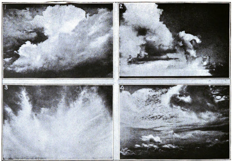
When these came to be examined, the following important generalizations were discovered:
[789]
1. That in general the configuration of the isobars assumed one of seven well-defined forms.
2. That, independent of the shape of the isobars, the wind always took a definite direction relative to the trend of those lines, and the position of the nearest area of low pressure.
3. That the velocity of the wind was always nearly proportional to the closeness of the isobars.
4. That the weather—that is to say, the kind of cloud, rain, fog, etc.—at any moment was related to the shape, and not the closeness, of the isobars, some shapes inclosing areas of fine, others of bad, weather.
5. That the regions thus mapped out by isobars were constantly shifting their position, so that changes of weather were caused by the drifting past of these areas of good or bad weather, just as on a small scale rain falls as a squall drives by. The motion of these areas was found to follow certain laws, so that forecasting weather changes in advance became possible.
6. That sometimes in the temperate zone, and habitually in the tropics, rain fell without any appreciable change in the isobars, though the wind conformed to the general law of these lines.
Observation also showed that, though the same shapes of isobars appear all over the world, the details of weather within them, and the nature of their motion, are modified by numerous local, diurnal, and annual variations. Hence modern weather science consists in working out for each country the details [790]of the character and motion of the isobars which are usually found over it; just as the geologist finds crumplings and denudation all over the world, and works out the history of the physical appearance of his own scenery by studying the local development of these agencies.
So far the science rests on pure observation—that such and such wind or weather comes with such and such a shape of isobars. But it has been found, still further, that the seven fundamental shapes of isobars are, as it were, the product of so many various ways in which an atmosphere circulating from the equator to the poles may move. Just as the motion of a river sometimes forms descending eddies or whirlpools, sometimes back-waters in which the water is rising upward, or yet at other times ripples in which the circulation is very complex, so it now appears that the general movement of the atmosphere from the equator to the pole sometimes breaks up into a rotating and descending movement round that configuration of isobars known as an anticyclone, sometimes into a rotating and ascending movement round that known as a cyclone, or at other times quite in a different way during certain kinds of squalls and thunderstorms.
Isobars, therefore, represent the effect on our barometers of the movements of the air above us, so that by means of isobars we trace the circulation and eddies of the atmosphere.
By carrying the general laws of physics into the conception of a circulating gas, we find that a cold mixed atmosphere of air and vapor descending into [791]a warmer soil would remain clear and bright; while a similar atmosphere rising into cooler strata would condense some of its vapor into rain or cloud. It is by reasoning of this nature that the origin of some of the most beautiful and complex forms of clouds has been discovered.
Following out these lines of research, a new science of meteorology has grown up, which entirely alters the attitude of mind with which we regard weather changes, and gives rise to an entirely new method of weather forecasting that far surpasses all previous efforts, and which explains and develops all that was known before.
On the one hand, the new method not only explains why certain prognostics are usually signs of good or bad weather, and the reason why the indications sometimes fail; but also the reason why rain, for instance, is sometimes foretold by one prognostic and sometimes by a totally different one.
On the other hand, it not only gives a more extended meaning to all the statistics which partially represent the climate of a place, and to the relation of the diurnal to the general changes of weather; but it also enables new inferences to be drawn, which had hitherto been impossible from some observations, and explains why other sets of figures must always remain without any physical significance.
We may notice here an attempt which has been made by one school of meteorologists to deduce all weather à priori from changes in the radiative energy of the sun; that is to say, that from a knowledge of greater or less heat being emitted by the sun, they [792]would treat the consequent alteration of weather as a direct hydrodynamical problem. Given an earth surrounded by fifty miles of damp air, and a sun at varying altitude, and of varying radiative energy, deduce from that all the diverse changes of weather. This is doubtless a very tempting ideal, for there is no doubt that the sun’s heat is the prime mover of all atmospheric circulation; but when we have explained what the nature of weather changes is, we see that there is little hope that this method will ever lead to satisfactory results.
Other meteorologists, who lay less stress on the varying power of the sun, have taken up the indications of synoptic charts, and endeavored to construct a mathematical theory of cyclones and the general circulation of the atmosphere. Ferrel, Mohn, Gulberg, Sprung, and others have all started with the analysis of the motion of a free mass of air on the earth’s surface, first given by Professor Ferrel, and worked out, from that and other general principles, schemes of the nature and propagation of cyclones, and of the general distribution of pressure over the world.
Depth of rainfall is, of course, ascertained by means of a rain-gauge, which measures the amount of water precipitated from the atmosphere during certain definite periods—usually twenty-four hours. Sir Christopher Wren has the credit of constructing [793]the first rain-gauge; but they have been made in various shapes and sizes since his time; and perhaps none of the instruments in the meteorologist’s armory is so familiar to the general public as the rain-gauge. The methods of using the instrument and the meaning of rainfall statistics are also thoroughly understood nowadays. However, behind these statistics and the methods of obtaining them, there are questions of great interest that obtrude themselves when we are watching the falling rain, and we desire to learn about the history of the raindrop—for example: Why is a raindrop round? How are raindrops formed? At what particular time does vapor become visible as mist? And what are the causes which change this mist into cloud and subsequently into rain?
The two prime causes of rain are, of course, the sun and the ocean; and since these two factors do not appreciably vary from year to year, it follows that the annual rainfall on the earth as a whole, if it could be measured, would also be found to be invariable. It is obvious, however, that the rainfall at all places is not equal. In London, for instance, the average yearly rainfall is twenty-two inches; but on the Khasi Hills in India it is no less than six hundred inches. Similar contrasts are observable in other parts of the world, the differences being due to local geographical conditions.
The starting points in the history of rain are, therefore, heat and moisture. From the surface of land and water tiny globules or vesicles of moisture are continually rising into the atmosphere by the [794]force of the sun’s heat; and the warmer the air the greater the number of these globules of water the atmosphere is able to absorb. In this respect the atmosphere may be likened to a sponge, for it is from the moisture thus retained that the subsequent raindrops are formed. Most persons are well acquainted with the very familiar phenomenon which is to be noticed when a glass of very cold water is brought into a warm room: the drops of moisture which form on the outside of the glass being among the commonest phenomena in what may be termed domestic meteorology. There is a similar transformation in the outside atmosphere; so that when the warm, moist currents of air flow against the sides of a cold mountain, or it may be against a body of cold air, there is a reduction in temperature, the atmosphere is squeezed like a sponge, and the particles of moisture are forced out of it. The particles then assume the form of cloud, fog, mist, rain, snow, and hail, as the case may be.
Now, as regards the globules of moisture, the most recent experiments and observations point to the conclusion that before the drops of vapor can form, there must be a tiny nucleus of dust upon which the condensed water may settle. At the centre of every drop of vapor in a cloud there is probably a little core of dust; and without these little atoms there could be no rain. These atoms of dust are visible only under the strongest microscopes; and so minute are they that in a cubic foot of saturated air it has been calculated that they number one thousand millions, their total weight being only three grains.
[795]
It is commonly considered that the particles of moisture within a cloud are quite motionless; and when looking at a huge cloud floating serenely in a summer sky it is difficult not to think of its constituent parts as being quite at rest. The apparently stationary cloud is all commotion and movement, the particles within it being always on the move, some going up and others down. The particles of moisture, moreover, being probably only about the four-thousandth part of an inch in diameter, the resistance offered by the air to their movement is very slight; indeed, as soon as they are condensed they immediately begin to fall downward, and were it not for the atoms of dust waiting to catch them the particles would at once fall to the ground. It is often asked why the vapor, if so readily condensed in the atmosphere, does not continually fall to the earth. The answer to this question, it will be seen, is that the moisture, instead of always pouring down on the earth, settles on the surface of the atoms of dust. Thus the first downward movement of the incipient raindrop is arrested by the dust-nuclei which swarm in all parts of the atmosphere; so that instead of being destroyed as soon as it is formed, the particle of moisture is preserved and stored for future use. In realizing the fact that a cloud is always in motion, the first step has been taken in discovering how a raindrop is formed.
It might be supposed that the raindrops would evaporate as quickly as they were condensed; but observation of the drops of moisture running down a window-pane and forming larger drops gives a good [796]idea of what occurs in the clouds; as also does the fact that in a bottle of soda-water the bubbles of air overtake one another and, colliding, make larger bubbles.
One of the principal causes of the manufacture of a raindrop is to be found in the circumstance that there is a similar process of amalgamation at work in every part of the atmosphere. It often happens that a drop of moisture falls downward through a cloud for a distance of a mile or more; and although it may pass through strata of very warm air, thus running a great risk of being evaporated and destroyed, it has also many collisions by which its bulk is considerably increased, and eventually becomes so heavy that its rate of progress is very much accelerated. Then, no longer able to float in the air, it plumps down to the earth as a full-grown raindrop.
Supposing it were possible for an observer to occupy a position immediately below a cloud, and close enough to see all that was taking place, he would notice raindrops of all sizes leaping from the under side of the cloud and plunging toward the earth. The simplest experiment to get some idea concerning the variation in raindrops is to expose an ordinary slate for a few minutes during a shower of rain, and it will be seen by the different-shaped blotches on the slate that, although the raindrops have all made a similar journey, they have, nevertheless, contrived to acquire an individuality during their downward passage. That the raindrops are round admits of a very simple explanation. They are this shape owing [797]to the action of capillarity, which in the case of the raindrop acts equally in all directions.
In many parts of the world the very curious phenomenon of colored rain sometimes occurs, and in many instances it is due to very simple causes. In some cases the coloring matter is found to be nothing but the pollen-dust shaken out of the flowers on certain trees at such times as a strong wind happened to be blowing over them. Fir trees and cypress trees, when grouped together in large forests, at certain seasons of the year give off enormous quantities of pollen, and this vegetable dust is often carried many miles through the atmosphere by the wind, and frequently falls to earth during a shower of rain. The microscope clearly reveals the origin of such colored rain, which has on more than one occasion puzzled and mystified the inexperienced. Pollen is, therefore, very largely responsible for the reports sent from different parts of the world of golden, black, and red rain. Fish and insects also descend to earth during showers of rain; but since it is probable that these and other unwonted visitors to the atmosphere were originally drawn up into the air during the passage across the country of a whirling storm, with powerfully ascending currents of air, there is no need to look for any far-fetched explanation of what, after all, is a very simple occurrence.
The history of a raindrop, then, has some very romantic and interesting episodes connected with it; but, wonderful as are the incidents in what is really a very remarkable career, it is not until the raindrops fall on the earth that the full purport of the [798]work they do is wholly realized. Contemplated by itself, a raindrop seems a very insignificant thing; but when the drops combine in a heavy downpour of rain the result is truly wonderful. The information that one inch of rain has fallen over a certain area is not very impressive; the amount does not seem very great. A fall of one inch of rain means, however, that no less than one hundred tons of water have fallen on each acre of surface, or no less than sixty thousand tons on each square mile. Instead of expressing the amount of water in tons, it may be thus stated in gallons, taking the Thames basin as a convenient area for reference: a rainfall of three inches over that area means that one hundred and sixty thousand million gallons of water have been precipitated from the atmosphere. At times, too, when the rainfall is still heavier, rivers overflow their banks and floods occur, and still further evidence is then forthcoming of the power and the might of the raindrops working toward one common end. Sooner or later the raindrop, whether it runs off the surface of the earth in a river or in a disastrous flood, finds its way, under the influence of evaporation, back into the atmosphere, and is then ready to start on another journey, which, like all its predecessors, will be full of incident from start to finish.
[799]
The oldest historic reference to the rainbow is known to all: “I do set my bow in the clouds, and it shall be for a token of a covenant between me and the earth.... And the bow shall be in the cloud; and I will look upon it, that I may remember the everlasting covenant between God and every living creature of all flesh that is upon the earth.”
To the sublime conceptions of the theologian succeeded the desire for exact knowledge characteristic of the man of science. Whatever its ultimate cause might have been, the proximate cause of the rainbow was physical, and the aim of science was to account for the bow on physical principles. Progress toward this consummation was very slow. Slowly the ancients mastered the principles of reflection. Still more slowly were the laws of refraction dug from the quarries in which Nature had imbedded them. I use this language because the laws were incorporate in Nature before they were discovered by man. Until the time of Alhazan, an Arabian mathematician, who lived at the beginning of the Twelfth Century, the views entertained regarding refraction were utterly vague and incorrect. After Alhazan came Roger Bacon and Vitellio, who made and recorded many observations and measurements on the subject of refraction. To them succeeded Kepler, who, taking the results tabulated by his predecessors, [800]applied his amazing industry to extract from them their meaning—that is to say, to discover the physical principles which lay at their root. In this attempt he was less successful than in his astronomical labors. In 1604, Kepler published his Supplement to Vitellio, in which he virtually acknowledged his defeat by enunciating an approximate rule, instead of an all-satisfying natural law. The discovery of such a law, which constitutes one of the chief corner-stones of optical science, was made by Willebrod Snell, about 1621.
A ray of light may, for our purposes, be presented to the mind as a luminous straight line. Let such a ray be supposed to fall vertically upon a perfectly calm water-surface. The incidence, as it is called, is then perpendicular, and the ray goes through the water without deviation to the right or left. In other words, the ray in the air and the ray in the water form one continuous straight line. But the least deviation from the perpendicular causes the ray to be broken, or “refracted,” at the point of incidence. What, then, is the law of refraction discovered by Snell? It is this, that no matter how the angle of incidence and with it the angle of refraction may vary, the relative magnitude of two lines, dependent on these angles, and called their sines, remains, for the same medium, perfectly unchanged. Measure, in other words, for various angles, each of these two lines with a scale, and divide the length of the longer one by that of the shorter; then, however the lines individually vary in length, the quotient yielded by this division remains absolutely [801]the same. It is, in fact, what is called “the index of refraction” of the medium.
Science is an organic growth, and accurate measurements give coherence to the scientific organism. Were it not for the antecedent discovery of the law of sines, founded as it was on exact measurements, the rainbow could not have been explained. Again and again, moreover, the angular distance of the rainbow from the sun had been determined and found constant. In this divine remembrancer there was no variableness. A line drawn from the sun to the rainbow, and another drawn from the rainbow to the observer’s eye, always inclosed an angle of 41°. Whence this steadfastness of position—this inflexible adherence to a particular angle? Newton gave to De Dominis[4] the credit of the answer; but we really owe it to the genius of Descartes. He followed with his mind’s eye the rays of light impinging on a raindrop. He saw them in part reflected from the outside surface of the drop. He saw them refracted on entering the drop, reflected from its back, and again refracted on their emergence. Descartes was acquainted with the law of Snell, and taking up his pen, he calculated, by means of that law, the whole course of the rays. He proved that the vast majority of them escaped from the drop as divergent rays, and, on this account, soon became so enfeebled as to produce no sensible effect upon the eye of an observer. At one particular angle, however—namely, the angle 41° aforesaid—they [802]emerged in a practically parallel sheaf. In their union was strength, for it was this particular sheaf which carried the light of the “primary” rainbow to the eye.
There is a certain form of emotion called intellectual pleasure which may be excited by poetry, literature, nature, or art. But I doubt whether among the pleasures of the intellect there is any more pure and concentrated than that experienced by the scientific man when a difficulty which has challenged the human mind for ages melts before his eyes, and re-crystallizes as an illustration of natural law. This pleasure was doubtless experienced by Descartes when he succeeded in placing upon its true physical basis the most splendid meteor of our atmosphere. Descartes showed, moreover, that the “secondary bow” was produced when the rays of light underwent two reflections within the drop, and two refractions at the points of incidence and emergence.
Descartes proved that, according to the principles of refraction, a circular band of light must appear in the heavens exactly where the rainbow is seen. But how are the colors of the bow to be accounted for? Here his penetrative mind came to the very verge of the solution, but the limits of knowledge at the time barred his further progress. He connected the colors of the rainbow with those produced by a prism; but then these latter needed explanation just as much as the colors of the bow itself. The solution, indeed, was not possible until the composite nature of white light had been demonstrated by [803]Newton. Applying the law of Snell to the different colors of the spectrum, Newton proved that the primary bow must consist of a series of concentric circular bands, the largest of which is red and the smallest violet; while in the secondary bow these colors must be reversed. The main secret of the rainbow, if I may use such language, was thus revealed.
I have said that each color of the rainbow is carried to the eye by a sheaf of approximately parallel rays. But what determines this parallelism? Here our real difficulties begin. Let us endeavor to follow the course of the solar rays before and after they impinge upon a spherical drop of water. Take, first of all, the ray that passes through the centre of the drop. This particular ray strikes the back of the drop as a perpendicular, its reflected portion returning along its own course. Take another ray close to this central one and parallel to it—for the sun’s rays when they reach the earth are parallel. When this second ray enters the drop it is refracted; on reaching the back of the drop it is there reflected, being a second time refracted on its emergence from the drop. Here the incident and the emergent rays inclose a small angle with each other. Take, again, a third ray a little further from the central one than the last. The drop will act upon it as it acted upon its neighbor, the incident and the emergent rays inclosing in this instance a larger angle than before. As we retreat further from the central ray the enlargement of this angle continues up to a certain point, where it reaches a maximum, [804]after which further retreat from the central ray diminishes the angle. Now, a maximum resembles the ridge of a hill, or a watershed, from which the land falls in a slope at each side. In the case before us the divergence of the rays when they quit the raindrop would be represented by the steepness of the slope. On the top of the watershed—that is to say, in the neighborhood of our maximum—is a kind of summit-level, where the slope for some distance almost disappears. But the disappearance of the slope indicates, as in the case of our raindrop, the absence of divergence. Hence we find that at our maximum, and close to it, there issues from the drop a sheaf of rays which are nearly, if not quite, parallel to each other. They are the so-called “effective rays” of the rainbow.
But though the step here taken by Descartes and Newton was a great one, it left the theory of the bow incomplete. Within the rainbow proper, in certain conditions of the atmosphere, are seen a series of richly colored zones, which were not explained by either Descartes or Newton. They are said to have been first described by Mariotte, and they long challenged explanation. At this point our difficulties thicken, but, as before, they are to be overcome by attention. It belongs to the very essence of a maximum, approached continuously on both sides, that on the two sides of it pairs of equal value may be found. The maximum density of water, for example, is 39° Fahr. Its density, when 5° colder and when 5° warmer than this maximum, is the same. So also with regard to the slopes of a watershed. A series [805]of pairs of points of the same elevation can be found upon the two sides of the ridge; and, in the case of the rainbow, on the two sides of the maximum deviation we have a succession of pairs of rays having the same deflection. Such rays travel along the same line, and add their forces together after they quit the drop. But light, thus reinforced by the coalescence of non-divergent rays, ought to reach the eye. It does so; and were light what it was once supposed to be—a flight of minute particles sent by luminous bodies through space—then these pairs of equally deflected rays would diffuse brightness over a large portion of the area within the primary bow. But inasmuch as light consists of waves, and not of particles, the principle of interference comes into play, in virtue of which waves alternately reinforce and destroy each other. Were the distance passed over by the two corresponding rays within the drop the same, they would emerge as they entered. But in no case are the distances the same. The consequence is that when the rays emerge from the drop they are in a condition either to support or to destroy each other. By such alternate reinforcement and destruction, which occur at different places for different colors, the colored zones are produced within the primary bow. They are called “supernumerary bows,” and are seen, not only within the primary, but sometimes also outside the secondary bow. The condition requisite for their production is that the drops which constitute the shower shall all be of nearly the same size. When the drops are of different sizes, we have a confused superposition of the different colors, [806]an approximation to white light being the consequence. This second step in the explanation of the rainbow was taken by a man the quality of whose genius resembled that of Descartes or Newton, and who in 1801 was appointed Professor of Natural Philosophy in the Royal Institution. I refer, of course, to the illustrious Thomas Young.
But our task is not, even now, complete. The finishing touch to the explanation of the rainbow was given by the eminent Astronomer Royal, Sir George Airy. Bringing the knowledge possessed by the founders of the undulatory theory, and that gained by subsequent workers, to bear upon the question, Sir George Airy showed that, though Young’s general principles were unassailable, his calculations were sometimes wide of the mark. It was proved by Airy that the curve of maximum illumination in the rainbow does not quite coincide with the geometric curve of Descartes and Newton. He also extended our knowledge of the supernumerary bows, and corrected the positions which Young had assigned to them. Finally, Professor Miller of Cambridge and Dr. Galle of Berlin illustrated with careful measurements with the theodolite the agreement which exists between the theory of Airy and the facts of observation. Thus, from Descartes to Airy, the intellectual force expended in the elucidation of the rainbow, though broken up into distinct personalities, might be regarded as that of an individual artist, engaged throughout this time in lovingly contemplating, revising, and perfecting his work.
The white rainbow (l’arc-en-ciel blanc) was first [807]described by the Spanish Don Antonio de Ulloa, lieutenant of the Company of Gentleman Guards of the Marine. By order of the King of Spain, Don Jorge Juan and Ulloa made an expedition to South America, an account of which is given in two amply illustrated quarto volumes to be found in the library of the Royal Institution. The bow was observed from the summit of the mountain Pambamarca, in Peru. The angle subtended by its radius was 33° 30′, which is considerably less than the angle subtended by the radius of the ordinary bow.
The white rainbow has been explained in various ways. The genius of Thomas Young throws light upon this subject, as upon so many others. He showed that the whiteness of the bow was a direct consequence of the smallness of the drops which produce it. The smaller the drops, the broader are the zones of the supernumerary bows, and Young proved by calculation that when the drops have a diameter of 1-3000th or 1-4000th of an inch, the bands overlap each other, and produce white light by their mixture.
Snow is the frozen moisture which falls from the atmosphere when the temperature is 32° or lower. It is composed of crystals, usually in the form of six-pointed stars, of which about 1,000 different kinds have been already observed, and many of them figured, by Scoresby, Glaisher, and others. These numerous forms have been reduced to five [808]principal varieties: Thin plates, the most numerous class, containing several hundred forms of the rarest and most exquisite beauty; spherical nucleus or plane figure studded with needle-shaped crystals; six or more rarely three-sided prismatic crystals; pyramids of six sides; prismatic crystals, having at the ends and middle thin plates perpendicular to their length. The forms of the crystals in the same fall of snow are generally similar to each other. The crystals of hoar-frost being formed on leaves and other bodies disturbing the temperature are often irregular and opaque; and it has been observed that each tree or shrub has its own peculiar crystals.
Snowflakes vary from an inch to 7-100ths of an inch in diameter, the largest occurring when the temperature is near 32°, and the smallest at very low temperatures. As air has a smaller capacity for retaining its vapor as the temperature sinks, it follows that the aqueous precipitation, snow or rain, is much less in polar than in temperate regions. The white color of snow is the result of the combination of the different prismatic rays issuing from the minute snow-crystals. Pounded glass and foam are analogous cases of the prismatic colors blending together and forming the white light out of which they had been originally formed. It may be added that the air contained in the crystals intensifies the whiteness of the snow. The limit of the fall of snow coincides nearly with 30° N. lat., which includes nearly the whole of Europe; on traversing the Atlantic, it rises to 45°, but on nearing America descends to near Charleston; rises on the west of America to 47°, and [809]again falls to 40° in the Pacific. It corresponds nearly with the winter isothermal of 52° Fahr. Snow is unknown at Gibraltar; at Paris, it falls 12 days on an average annually, and at St. Petersburg 170 days. It is from 10 to 12 times lighter than an equal bulk of water. From its loose texture, and its containing about 10 times its bulk of air, it is a very bad conductor of heat, and thus forms an admirable covering for the earth from the effects of radiation—it not infrequently happening, in times of great cold, that the soil is 40° warmer than the surface of the overlying snow. The flooding of rivers from the melting of the snow on mountains in summer carries fertility into regions which would otherwise remain barren wastes.
The word hail in English is unfortunately used to denote two phenomena of apparently different origin. In French, we have the terms grèle and grésil—the former of which is hail proper; the latter denotes the fine grains, like small shot, which often fall in winter, much more rarely in summer, and generally precede snow. The cause of the latter seems to be simply the freezing of raindrops as they pass in their fall through a colder region of air than that where they originated. We know by balloon ascents and various other methods of observation that even in calm weather different strata of the atmosphere have extremely different temperatures, a stratum far under the freezing point being often observed between two others comparatively warm.
But that true hail, though the process of its formation is not yet perfectly understood, depends [810]mainly upon the meeting of two nearly opposite currents of air—one hot and saturated with vapor, the other very cold—is rendered pretty certain by such facts as the following. A hailstorm is generally a merely local phenomenon, or at most, ravages a belt of land of no great breadth, though it may be of considerable length. Hailstorms occur in the greatest perfection in the warmest season, and at the warmest period of the day, and generally are most severe in the most tropical climates. A fall of hail generally precedes, sometimes accompanies, and rarely, if ever, follows a thunder-shower.
When a mass of air, saturated with vapor, rising to a higher level, meets a cold one, there is, of course, instant condensation of vapor into ice by the cold due to expansion; at the same time, there is generally a rapid production of electricity, the effect of which upon such light masses as small hailstones is to give them in general rapid motion in various directions successively. These motions are in addition to the vortex motions or eddies, caused in the air by the meeting of the rising and descending currents. The small ice-masses then moving in all directions impinge upon each other, sometimes with great force, producing that peculiar rattling sound which almost invariably precedes a hail-shower. At the same time, by a well-known property of ice, the impinging masses are frozen together; and this process continues until the weight of the accumulated mass enables it to overcome the vortices and the electrical attractions, when it falls as a larger or smaller hailstone. On examining such hailstones, which may [811]have any size from that of a pea to that of a walnut, or even an orange, we at once recognize the composite character which might be expected from such a mode of aggregation.
A curious instance of the fall of large hail, or rather ice-masses, occurred on one of her Majesty’s ships off the Cape in January, 1860. Here the stones were the size of half-bricks, and beat several of the crew off the rigging, doing serious injury. We may conclude by a description (taken from Mem. de l’Acad. des Sciences, 1790) of one of the most disastrous hailstorms that has occurred in Europe for many years back. This storm passed over Holland and France in July, 1788. It traveled simultaneously along two lines nearly parallel—the eastern one had a breadth of from half a league to five leagues, the western of from three to five leagues. The space between was visited only by heavy rain; its breadth varied from three to five and a half leagues. At the outer border of each, there was also heavy rain, but we are not told how far it extended. The length was at least a hundred leagues; but from other reports it may be gathered that it really extended to nearly two hundred. It seems to have originated near the Pyrenees, and to have traveled at a mean rate of about sixteen and a half leagues per hour toward the Baltic, where it was lost sight of. The hail only fell for about seven and a half minutes at any one place. The hailstones were generally of irregular form, the heaviest weighing about eight French ounces. This storm devastated 1,039 parishes in France alone, and the damage was officially placed at 24,690,000 francs.
[812]
For any assigned temperature of the atmosphere, there is a certain quantity of aqueous vapor which it is capable of holding in suspension at a given pressure. Conversely, for any assigned quantity of aqueous vapor held in suspension in the atmosphere, there is a minimum temperature at which it can remain so suspended. This minimum temperature is called the dew-point. During the daytime, especially if there has been sunshine, a good deal of aqueous vapor is taken into suspension in the atmosphere. If the temperature in the evening now falls below the dew-point, which after a hot and calm day generally takes place about sunset, the vapor which can be no longer held in suspension is deposited on the surface of the earth, sometimes to be seen visibly falling in a fine mist. This is one form of the phenomenon of dew, but there is another. The surface of the earth, and all things on it, and especially the smooth surfaces of vegetable productions, are constantly parting with their heat by radiation. If the sky is covered with clouds, the radiation sent back from the clouds nearly supplies an equivalent for the heat thus parted with; but if the sky be clear, no equivalent is supplied, and the surface of the earth and things growing on it become colder than the atmosphere.
If the night also be calm, the small portion of air contiguous to any of these surfaces will become cooled below the dew-point, and its moisture deposited on the surface in the form of dew. If this chilled temperature be below 32° Fahr., the dew becomes frozen and is called hoar-frost. The above two phenomena, though both expressed in our language [813]by the word dew, which perhaps helps to give rise to a confusion of ideas on the subject, are not necessarily expressed by the same word. For instance, in French, the first phenomenon—the falling evening-dew—is expressed by the word serein; while the latter—the dew seen in the morning gathered in drops by the leaves of plants, or other cool surfaces—is expressed by the word rosée.
The merit of the discovery of the “Theory of Dew” has been commonly ascribed to Dr. William Charles Wells, who published in 1814 his Essay on Dew, which obtained great popularity. The merit should, however, be divided between him and several others. M. Le Roi of Montpellier, M. Pictet of Geneva, and especially Professor Alexander Wilson of Glasgow, largely contributed by experiment and inducement to its formation.
The aurora is one of those phenomena of nature which are characterized by exceeding beauty, and sometimes by an imposing grandeur, but are unaccompanied by any danger, and indeed, so far as can be determined, by any influence whatever upon the conditions which affect our well-being. Comparing the aurora with a phenomenon akin to it in origin—lightning—we find in this respect the most marked contrast. Both phenomena are caused by electrical discharges; both are exceedingly beautiful. It is doubtful which is the more imposing so [814]far as visible effects are concerned. When the auroral crown is fully formed, and the vault of heaven is covered with the auroral banners, waving hither and thither silently, now fading from view, anon glowing with more intense splendor, the mind is not less impressed with a sense of the wondrous powers which surround us than when, as the forked lightnings leap from the thundercloud, the whole heavens glow with violet light, and then sink suddenly into darkness. The solemn stillness of the auroral display is as impressive in its kind as the crashing peal of the thunderbolt.
The reader is no doubt aware that auroras or polar streamers, as they are sometimes called, are appearances seen not around the true poles of the earth, but around the magnetic poles which lie very far away from those geographical poles which our Arctic and Antarctic seamen have in vain attempted to reach. The formation of auroral streamers around the magnetic poles of the earth shows that these lights are due to electrical discharges of electricity, which, though only visible at night, take place in reality in the daytime also.
Remembering that the aurora is due to electrical discharges in the upper regions of the air, it is interesting to learn what are the appearances presented by the aurora at places where the auroral arch is high above the horizon—these being, in fact, places nearly under the auroral arch. M. Ch. Martins, who observed a great number of auroras in Spitzbergen in 1839, thus writes: “At times they are simple diffused gleams or luminous patches; at others, quivering rays [815]of pure white which run across the sky, starting from the horizon as if an invisible pencil were being drawn over the celestial vault; at times it stops in its course, the incomplete rays do not reach the zenith, but the aurora continues at some other point; a bouquet of rays darts forth, spreads into a fan, then becomes pale, and dies out. At other times long golden draperies float above the head of the spectator, and take a thousand folds and undulations as if agitated by the wind. They appear to be but at a slight elevation in the atmosphere, and it seems strange that the rustling of the folds as they double back on each other is not audible. Generally, a luminous bow is seen in the north; a black segment separates it from the horizon, the dark color forming a contrast with the pure white or bright red of the bow, which darts forth rays, extends, becomes divided, and soon presents the appearance of a luminous fan, which fills the northern sky, and mounts nearly to the zenith, where the rays, uniting, form a crown, which in its turn darts forth luminous jets in all directions. The sky then looks like a cupola of fire; the blue, the green, the yellow, the red, and the white vibrate in the palpitating rays of the aurora. But this brilliant spectacle lasts only a few minutes; the crown first ceases to emit luminous jets, and then gradually dies out; a diffused light fills the sky; here and there a few luminous patches, resembling light clouds, open and close with incredible rapidity, like a heart that is beating fast. They soon get pale in their turn, everything fades away and becomes confused, the aurora seems to be in its death-throes; the stars, which [816]its light had obscured, shine with a renewed brightness; and the long polar night, sombre and profound, again assumes its sway over the icy solitudes of earth and ocean.”
The association between auroral phenomena and those of terrestrial magnetism has long been placed beyond a doubt. Wargentin in 1750 first established the fact, which had been previously noted, however, by Halley and Celsius. But the extension of the relation to phenomena occurring outside the earth—very far away from the earth—belongs to recent times. The first point to be noticed, as showing that the aurora depends partly on extra-terrestrial circumstance, is the fact that the frequency of its appearance varies greatly from time to time. It is said that the aurora was hardly ever seen in England during the Seventeenth Century, although the northern magnetic pole was then much nearer to England than it is at present Halley states that before the great aurora of 1716 none had been seen (or at least recorded) in England for more than eighty years, and no remarkable aurora since 1574. In the records of the Paris Academy of Sciences no aurora is mentioned between 1666 and 1716. At Berlin one was recorded in 1707 as a very unusual phenomenon; and the one seen at Bologna in 1723 was described as the first which had ever been seen there. Celsius, who described in 1733 no less than three hundred and sixteen observations of the aurora in Sweden between 1706 and 1732, states that the oldest inhabitants of Upsala considered the phenomenon as a great rarity before 1716. Anderson of Hamburg states that in [817]Iceland the frequent occurrence of auroras between 1716 and 1732 was regarded with great astonishment. In the Sixteenth Century, however, they had been frequent.
Here then we seem to find the evidence of some cause external to the earth as producing auroras, or at least as tending to make their occurrence more or less frequent. The earth has remained to all appearance unchanged in general respects during the last three centuries, yet in the Sixteenth her magnetic poles have been frequently surrounded by auroral streamers; during the Seventeenth these streamers have been seldom seen; during the last two-thirds of the Seventeenth Century auroras have again been frequent; and during the Eighteenth Century they have occurred sometimes frequently during several years in succession, at others very seldom.
Connected as auroras are with the phenomena of terrestrial magnetism, we may expect to find some help in our inquiry from the study of these phenomena. Now it appears certain that magnetic phenomena are partly influenced by changes in the sun’s condition. We may well believe that they are in the main due to the sun’s ordinary action, but the peculiarities which affect them seem to depend on changes in the sun’s action.
Many of my readers will doubtless remember the auroras of May 13, 1869, and October 24, 1870, both of which occurred when the sun’s surface was marked by many spots, and both of which were accompanied by remarkable disturbance of the earth’s magnetism.
It may, then, fairly be assumed that the occurrence [818]of auroras depends in some way, directly or indirectly, on the condition of the sun. But what the real nature of that connection may be is not easily determined.
Angström was the first to observe the spectrum of the aurora borealis. He found that the greater part of the auroral light, as observed in 1867, was of one color, yellow, but three faint bands of green and greenish blue color were also seen. The aurora of April 15, 1869, was seen under very favorable conditions in America. Professor Winlock, observing it at New York, found its spectrum to consist of five bright lines, of which the brightest was the yellow line just mentioned. One of the others seems to agree very nearly, if not exactly, in position with a green line, which is the most conspicuous feature of the spectrum of the solar corona. During the aurora of October 6, 1869, Flögel noticed the strong yellow line and a faint green band. Schmidt, on April 5, 1870, made a similar observation. He saw the strong yellow line, and from it there extended toward the violet end of the spectrum a faint greenish band, which, however, at times showed three defined lines, fainter than the yellow line.
It was not till the magnificent aurora of October 24-25, 1870, that any red lines were seen in the spectrum of an aurora. On that occasion the background of the auroral light was ruddy, and on the ruddy background there were seen three deep red streamers very well defined. The ruddy streamers, on the night of October 25, converged toward the auroral crown, which was on that occasion singularly well seen. [819]Förster of Berlin failed to see any red line or band despite the marked ruddiness of the auroral light. But Capron at Guildford saw a faint line in the red part of the spectrum; and Elger at Bedford observed a red band in the light of the red streamers, the band disappearing, however, when the spectroscope was directed on the white rays of the aurora.
As yet the auroral spectrum has not been interpreted. The reason probably is, that the conditions under which the light of the aurora as of the corona is formed are not such as have been or perhaps can be attained or even approached in laboratory experiments.
Those who are professionally engaged in the scientific work of weather bureaus recognize the importance of accurate observations of cloud forms and nature, and much good work has been done in this connection in recent years by scientific observers in England, Australia, and the United States; but as a popular study, nephology is almost entirely overlooked, and this notwithstanding the fact that, perhaps, no branch of knowledge offers greater facility and ease of acquisition. Each cloud has its history fraught with meaning; its open secret is writ on its face, and may be read by any one who will, give himself a little trouble, nor need he go deeply into the study in order to make observations interesting to himself, and perhaps of great use in the furthering and perfecting of weather lore. To [820]the ancients, the sky was doubtless an object of constant remark and interest, and possibly their intuitive knowledge of weather forecasting was much more accurate than ours. The dwellers in our modern cities see little of the sky, clouds have no interest for them beyond the personal consideration as to the advisability of taking out an umbrella or not. But farmers, fishermen, sailors, and others following open-air avocations are dependent on the weather, and to be wise in its forecast is of importance to them. To these, especially, cloud study should appeal; it can not fail to be profitable to them in their personal work, and they have all the opportunity, if the will be there, to forward the general knowledge of the subject by careful painstaking observations, which they may transmit to those scientifically engaged in dealing with weather laws, and thus assist in the elucidation of questions on which we are at present but very imperfectly informed.
In this article the broad distinctions of clouds will be dealt with. There are two well-defined types—Stratus and Cumulus—so distinct in actual appearance and in physical formation that they may be taken as the basis of classification. Sometimes both types appear to merge into each other, in which case no variety of classification suffices to describe them satisfactorily, as any one who has studied cloud-forms must allow. “Stratus” is a sheet-like formation of cloud. “Cumulus” is recognizable by its heaped-up appearance and vertical thickness. Numerous varieties of cloud-forms may be observed graduating from one of these types to the other, but [821]when an observer can clearly distinguish Stratus from Cumulus he has already acquired valuable knowledge.
The presence of either type of cloud alone indicates a more or less set condition of the atmosphere, and generally foretells a continuance of the existing weather. The simultaneous presence of both types indicates a coming change, the gradation of Stratus into Cumulus foreboding worse weather, and of Cumulus into Stratus heralding good. Again, as we shall show later on, the vertical thickening of the stratiform clouds is a distinctly bad indication.
Up to quite recently, Luke Howard’s division of clouds, formulated in 1802, held first place; even now it is in constant use, for though attempts have been made at a more scientific classification, all of them, with the single exception of that proposed by the late Rev. Clement Ley, can only be termed make-shifts. Mr. Ley’s classification, unfortunately, is long, and not well adapted to the use of any but professional investigators, or enthusiasts with ample time on their hands. There exists a so-called “international” system of cloud nomenclature, but, for all that, each country has its own especial system, with the result that vast collections of cloud statistics are of little value as helps to a classification, and are useful only as records of clouds present at certain times.
Clouds owe their existence to two causes:
1. Through the passing of warm, moist air into colder, when, owing to condensation, a certain proportion of the moisture becomes visible in the form of a cloud.
[822]
2. Through changes occurring in the atmosphere as it rises into higher regions of atmosphere, where decrease in pressure and expansion and consequent loss of heat take place and cause condensation of moisture.
The first process may be described as the condensation formation of clouds, and the second as the adiabatic formation of clouds. As a matter of fact, no hard and fast line separates these two operations; they act in unison, and the combination of vertical and horizontal currents goes to make up the diversity of forms which clouds assume.
In settled states of the atmosphere, Stratus clouds are common, or the sky may be clear. In unsettled conditions, Cumulus or Heap clouds are formed.
We shall now describe a few familiar forms of cloud, giving them simple names and endeavoring to compare them with other nomenclatures.
Of Cumulus clouds there are five well-defined varieties.
Rain Cumulus, of which there are two sub-varieties:
(a) Shower-cumulus, when rain falls from the cloud without increment of wind. The edges of this cloud are not cirrus-topped.
(b) Squall-cumulus, when the rain is accompanied by wind, or by wind with hail and snow falling from this cloud.
In these cases the Cumulus cloud is generally much serrated, having a cirriform edging. In some cases this cirriform edging extends far over the sky and forms halos, particularly at the rear.
[823]
Two rarer varieties of Cumulus are:
Pillar-cumulus, generally noticed over the calm belts of the ocean, and distinguishable by its slender forms, which rise to great altitudes.
Roll-cumulus generally accompanies strong winds, particularly polar west winds, which succeed cyclonic disturbances. Here we have the ordinary Cumulus cloud so blown along by the wind as to assume the roll formation from which it is named.
A still rarer form of Cumulus appears in scattered patches over the sky, and is indicative of an electrical state of the atmosphere.
Cumulus clouds form at a low altitude, but they frequently tower upward to great heights.
It should be noticed that in these clouds the fine weather form is of soft, smooth outline, and has a quiet appearance.
Stratus Clouds may be divided into four varieties as follows:
1. Fog, so well known as not to need description. It is, in fact, a Stratus cloud resting on the earth’s surface.
2. Stratus, a cloud sheet which covers the whole sky at a moderate elevation. Here and there the cloud is thin, and under surfaces appear as parallel lines all round the horizon. This is the characteristic cloud of anti-cyclonic, or dry, fine weather conditions. It may continue to cover the sky for several days in succession.
3. High Stratus, including all the varying forms of Cirro-cumulus from the mackerel skies to the Cirro-macula of Clement Ley. Many beautiful varieties [824]of this cloud of minute cumuliform appearance are caused by the changes taking place in the atmosphere. We notice waves, wavelets, stipplings, and flecks. To it are due the coronas sometimes seen round the sun, as also iridescent clouds occasionally noticed in the same vicinity. The wave-like appearance of the clouds is due to the passage of a more rapidly moving air current over a slower one, or of a wave current crossing a motionless portion of the air. When two air currents pass over one another at an angle, the particles of clouds tend to fall into different shapes, hence our mackerel skies. But this cloud, although beautiful, is essentially one of warning, more especially when the flecks are of a thin, scaly appearance (resembling the scales of certain fishes so closely that I have called it the scale cloud). Sometimes these detached flecks appear in lines, and very striking is the effect produced.
4. Cirrus.—The highest form of cloud and the most important as a factor in the science of weather forecasting. Cirrus, ordinarily, appears as wisps and feather pieces scattered over the sky, and its significance is then of no import.
When, however, this cloud takes the form of lines parallel to the horizon, or of lines appearing to radiate as wheel-spokes from any one part of the horizon, it should be carefully noted as indicative of approaching weather. Its movement and propagating transition should be observed. This cloud is composed of ice-dust or crystals.
When a cyclonic disturbance is about to pass over an observer, Cirrus generally appears first in parallel [825]lines, or at a radiant point; the threads gradually increase and interlace until a complete sheet of Cirro-stratus covers the sky, causing a halo. The cloud further thickens, the halo disappears, all becomes overcast, and rain comes on. The cloud is now known as Nimbus, and after it has endured some time, the wind shifts, the Nimbus clears off, and it is succeeded by a polar west wind.
In addition to these forms of clouds, we may often notice, particularly during high winds, fragments of clouds hurrying across the sky. These are known as “scud”; they are generally pieces carried off by the winds from the main bodies of clouds.
Occasionally two forms of cloud are present at the same time. This is ordinarily taken as a case of Cumulus and Stratus, and has become known as Cumulo-stratus; but, if observed in the zenith, it may readily be noted that the two forms of cloud are distinct, and they had better be dealt with separately. The appearance of Cumulo-stratus is an effect of perspective.
Clouds float at varying altitudes, according to the latitude and elevation of the ground; the vertical temperature and adiabatic gradients determining the level at which the vapor becomes visible as cloud. It is desirable in all cloud observations, that note should be made of the approximate relative altitudes of clouds and of their velocity of motion. This is particularly desirable when dealing with the stratiform clouds, whether as ordinary Cirro-cumulus or as very high Cirro-macula.
The beautiful coloring of clouds results from the [826]breaking up of light beams in passing through them or along their edges. This phenomenon is caused by diffraction, and to it is due our lovely sunrises and sunsets. When the sun is high in the heavens, the light is white, but as the orb nears the horizon, and its rays pass through thicker layers of atmosphere, the smaller light waves get gradually cut off, until the sun sinks as a red ball below the horizon. The largest waves of light produce the red rays and the after glow which are so beautiful. Sunrise and sunset effects are matters of much interest, but are of too complicated a nature to be fully gone into here; we must, however, notice them briefly, because of their importance in weather forecasts. Soft sunset colors indicate fine settled weather; fiery brilliant hues denote change to stormy or wet weather.
Other color effects in clouds are due to phenomena, known as halos and coronas. Halos appear as rings round the sun and moon; they are caused by the shining of the orb through very high Stratus or Cirrus clouds, and have a diameter of 42°. Sometimes shades of color, resembling those of a rainbow, are visible—red appears on the inside and blue on the outside. These rings of color are due to the reflection and refraction of light passing through the fine ice crystals of which high Stratus or Cirrus clouds are composed. Occasionally a complicated series of beautifully colored rings is noticeable. Generally speaking, these rings are due to the thinness of the high cloud through which the light is passing. Still more curious arrangements of halos sometimes occur.
[827]
Coronæ are broader rings seen quite close to the sun or moon, and are due to the shining of light through the edges of loose Cumulus or Stratus clouds. They have red on the outside and blue on the inside of the ring; the colors are, generally, easily distinguishable. The more brilliant hues occasionally seen, as has been said, in the vicinity of the sun and moon, would appear to be incomplete sections of circles intermediate in size between coronæ and halos. An interested observer will be well repaid if he chooses to study more closely the many curious optical phenomena connected with clouds, but it would be beyond the scope and object of this paper to go into them more fully here.
Whoever wishes to be weatherwise, and who has time to study the weather charts published daily, may easily acquire such knowledge of local characteristics as will enable him to forecast fairly accurately. Cirrus clouds, as a rule, are reliable guides; they form, as we have said, in parallel threads, from the position and movements of which forecasts may be made. Should the threads appear on, and parallel to, the west horizon, and moving from a northerly point, a depression is approaching from the west, but, although causing some bad weather, it will probably pass to the north of the observer. Should the lines appear parallel to the southwest or south-southwest horizon, and be moving from a northwesterly point, the depression will very likely pass over the observer and occasion very bad weather. These are two of many possible prognostics. Weather forecasting is much helped by a study [828]of the daily weather charts. Again, weather is often very local, and to predict with fair accuracy a knowledge of local conditions is necessary.
Among the secondary causes affecting climate, probably none is of greater importance than the direction of prevailing winds. The currents of air are warm or cold, wet or dry, according as they have had their origin in warm or cold latitudes, and have traversed inland tracts, or the expanse of ocean, in their advancing course. With us, and in the northern half of the globe in general, north and east winds are cold and dry, while south and west winds are warm, and often accompanied by moisture. Within the Southern Hemisphere these conditions are reversed, and the hottest currents of air come from a northwardly direction. The prevailing winds of western Europe are from the west and southwest; and it is to this fact that we must mainly ascribe the high winter temperature, as well as the comparative freedom from extremes of heat and cold which distinguishes the countries of western Europe. The same cause explains the abundant moisture which belongs to those regions in general, and which distinguishes the western shores of our own islands in a remarkable degree. Such winds have traversed the immense expanse of the Atlantic, and come to the western seaboard of Europe laden with the moist vapors gathered on their course. These vapors, condensed upon the high grounds which line the western [829]side of the British Islands, or, further to the northward, upon the long chain of the Scandinavian Mountains, fall to the earth in copious torrents of rain. In the process of condensation, a vast quantity of latent heat is disengaged, and the temperature is correspondingly raised. Warmth and moisture are, indeed, speaking generally, concomitant conditions of European climate, and are especially so in the case of western Europe.
Even in the case of lands which nearly approach the tropic, the influence of prevailing winds in raising or lowering the temperature is strikingly seen. At New Orleans, bordering on the Mexican Gulf, and throughout the adjacent portions of the United States, the winters are often of excessive severity. Cold winds, generated in the higher latitudes of the New World, and blowing for weeks in succession from the northern quarter of the sky, are the cause of this. The generally level interior of the North American Continent—a vast lowland plain, bounded only to the east and west by the Alleghanies and the Rocky Mountains—presents no obstacle to the advance of these cold northerly blasts. The middle and eastwardly parts of North America are subject to like influences, in this regard, to the plains of eastern Europe. To the westward of the Rocky Mountains, on the other hand, the conditions affecting climate present greater analogy to those that belong to western Europe.
In the case of many countries, some local wind, of occasional prevalence, forms a marked characteristic of climate. The most remarkable of these local [830]winds are the simoon, the sirocco, the föhn, the harmattan, and the mistral.
The often-described simoon of the desert is an intensely heated and dry wind, which raises the temperature like the blast of a furnace, and fills the air with particles of sand, of suffocating quality. The same wind is known in the deserts of Turkestan as the tebbad (fever-wind), the terrible conditions of which are thus described by the pen of a traveler. “The kervanbashi (leader of the caravan) and his people drew our attention to a cloud of dust that was approaching, and told us to lose no time in dismounting from the camels. These poor brutes knew well enough that it was the tebbad that was hurrying on; uttering a loud cry they fell on their knees, stretched their long necks along the ground, and strove to bury their heads in the sand. We intrenched ourselves behind them, lying there as behind a wall; and scarcely had we, in our turn, knelt under their cover, than the wind rushed over us with a dull, clattering sound, leaving us, in its passage, covered with a crust of sand two fingers thick. The first particles that touched me seemed to burn like a rain of flakes of fire. Had we encountered it when we were deeper in the desert we should all have perished. I had not time to make observations upon the disposition to fever and vomiting caused by the wind itself, but the air became heavier and more oppressive than before.”
The sirocco of the Mediterranean coasts is the hot wind of the African desert, tempered, before reaching the coasts of southern Europe, by its passage [831]across the great expanse of inland waters. The enervating influences of this wind are well known to the resident on the shores of Sicily, the Italian mainland, or the islands of the Archipelago. The same wind, when it reaches the high mountain regions of the Apennines and the Alps, is known as the föhn.
The föhn, or warm south wind, is an important agent in modifying the climate of the higher Alpine region, where its prevalence for a few days in succession causes the snow-line to recede, and is often accompanied by inundations occasioned by the suddenly melted snows. Its absence during a longer period than usual is attended, on the other hand, by a prolongation of the glaciers into a lower region of the mountain valleys. The Swiss peasants have a saying, when they talk of the melting of the snow, that the sun could do nothing without the föhn.
The harmattan of Senegambia and Guinea is a cold and intensely dry wind, which blows from the northeast during the months of December and January.
The mistral of southern France possesses similar qualities to the last-named wind, and blows, for days together, down the valley of the Rhone.
Winds transport particles of dust, and, with them, the minuter forms of vegetable and animal life, to vast distances. The phenomena known to sailors as red fogs and sea-dust are evidence of this. In the Mediterranean, and also in the neighborhood of the Cape Verde Islands, showers of dust, of brick-red or cinnamon color, are sometimes experienced in such quantity as to cover the sails and rigging hundreds [832]of miles away from land. Among this sea-dust, examination with the microscope has detected infusoria and other organisms native to the tropical regions of South America.
The prevailing currents of the atmosphere, or winds, constitute an important feature in the climate of any country, and it belongs to Physical Geography to explain the prevalent winds which distinguish great regions of the globe. Such explanation is more easily made in regard to the warmer latitudes of the earth, where alone the direction of the wind is constant, than might be at first supposed by those whose personal experience is limited to such countries as Britain, and other temperate lands, where the variable condition of the atmosphere is the well-known subject of common observation and remark. But within those parts of the globe which experience a vertical sun, and for a few degrees beyond the exact line which marks the limit of the sun’s vertical influence on either side of the equator, the conditions either of perennial calm, or of currents of air that constantly blow in one given direction, are the uniform characteristics of climate.
Throughout a zone of a few degrees in breadth, which extends round the globe in the neighborhood of the equator, and the limits of which undergo a certain amount of variation, dependent on the sun’s passage of the equinox, the variation of temperature throughout the year is confined within very narrow limits, and the result is a general prevalence of calms—that is, of undisturbed atmosphere. Wind is air set in motion, mainly by the existence of different [833]conditions of temperature between adjacent bodies of air—of colder and denser air pressing against warmer and lighter air, and taking the place which is left vacant by the latter, as it rises into the higher regions of the entire aerial sea. Between the heated air of the tropics in general, and the comparatively cooler air of the regions lying some distance north and south of the tropics, for example, there is a very manifest difference as to temperature, as well as in regard to other conditions; but for a few degrees in the immediate neighborhood of the equator there is no such obvious difference, and, consequently, nothing to occasion disturbance (temperature alone being considered) in the general equilibrium of the atmosphere. Hence the prevalence of calms in that region. Within the parallels of 8° or 10° on either side of the line, the angle at which the solar rays reach the earth is at no time more than a few degrees from the perpendicular, for the equator divides the total amount of angular difference which is involved in the entire yearly path of the sun.
The average breadth of the calm latitudes—or the Zone of Calms, as it is the custom, in books and maps, to term it—may be stated at about six or seven degrees. The mid-line of this zone does not coincide with the equator, for the reason that the equator does not represent the line of the earth’s highest temperature, owing to the preponderance of land in the Northern Hemisphere. Hence the Zone of Calms is, for the most part, to the northward of the equator—extending, with varying seasonal limits, [834]from about the first to the seventh or eighth parallel of north latitude. But the limits oscillate with the sun’s passage of the equinox and consequent place in the heavens vertically over either side of the equator.
The calm latitudes are the dread of the mariner, whose ship is often delayed for weeks together within their limits. The wearisome and tantalizing nature of this delay can, perhaps, only be adequately appreciated by those who have experienced the monotony attendant on a calm in mid-ocean, when, with a still and glassy sea around, a glittering atmosphere, and a burning sun overhead, the sails hang idly by the yards, and the vessel makes no appreciable progress.
Between the oscillating limit of the Zone of Calms and the parallel of 28° in the Northern Hemisphere, on one side of the globe, and between the correspondent limit and the parallel of 25° south latitude, on the opposite hemisphere, there prevail through above two-thirds of the earth’s circumference, steady winds, blowing with almost undeviating uniformity from the eastward. These are the trade-winds. More precisely, the trade-wind of the Northern Hemisphere is a wind blowing from the northeastward—that is, a northeast wind. The trade-wind of the Southern Hemisphere blows from the southeastward, and is a southeast wind.
The trade-wind belts stretch round more than two-thirds of the earth’s surface. They comprehend (within the latitudinal limits already defined) the Atlantic and Pacific Oceans, with the countries that lie adjacent to those vast areas of water. In the [835]Pacific, however, their limits are less distinctly marked, and their influence less powerful, to the southward of the equator than to the north of that line. Over the Indian Ocean and its shores, the atmospheric currents follow, during portions of the year, an opposite course.
The trade-winds of the Atlantic and Pacific—blowing constantly, and with almost undeviating steadiness, from the eastward—regulate the course of the mariner across those oceans. They, of course, facilitate the passage of either ocean in a westerly direction—that is, from the shores of the Old World to the eastern seaboard of America, or from the western coast of the New World to the eastern shores of the Asiatic and Australian Continents. It was the trade-wind of the Northern Atlantic that carried Columbus to the westward, on the adventurous voyage which resulted in the discovery of the New World, inspiring terror in the breasts of his companions, while in the mind of the great navigator himself it strengthened the assurance of reaching land by pursuing the direction in which his vessels’ prows were turned. On a like great occasion, the trade-wind of the Pacific carried Magellan’s ship steadily forward through the ocean which he was the first to cross, and facilitated the earliest circumnavigation of the globe. On the other hand, the same winds compel the return voyage across either ocean to be made in higher latitudes, where westerly winds prevail.
The explanation of the trade-winds is found in the different measure in which the sun’s heat is experienced [836]by regions within or nearly adjacent to the tropics, and by those of higher latitudes. They are currents of air set in motion by the differences of density consequent upon such various conditions of temperature—conditions which are of uniform prevalence, and the result of which is also constant.
To sum up, we may say that the trade-winds, like the currents of the ocean, are due, first, to the sun,—that is to the different measure in which the solar heat is distributed on the globe’s surface; and, secondly, to the earth’s axial rotation, which affects the direction of currents in the aerial ocean in manner precisely analogous to that in which it affects the like currents in the aqueous ocean. In truth, the ocean of water, and the ocean of air—in contact with one another, and possessing many properties in common—act and react upon one another, mutually imparting their respective temperatures, movements, and other conditions. This is only one among the instances of mutual harmony—one of the many mute sympathies—which abound in the natural world.
The monsoons are winds which blow over the Indian Ocean, and the countries adjacent to its waters. In general terms, it may be said that they prevail within the same latitudes as those over which the trade-winds of the Atlantic and Pacific blow. But the monsoons differ from the trade-winds of the two greater oceans in the fact that they are periodical winds, not perennial. The monsoon blows for half the year from one quarter of the heavens, and for the other half from an opposite quarter.
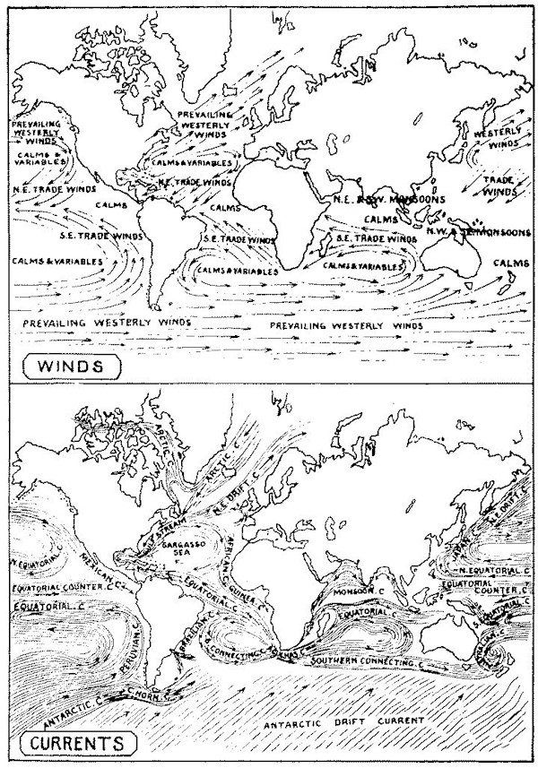
Over the northerly portion of the Indian Ocean—from [837]the neighborhood of the equator to the shores of the Asiatic Continent, including the Malay Archipelago and the adjacent China Sea—a northeast monsoon blows during the winter months of the Northern Hemisphere; that is, from October to March, inclusive. During the summer months—April to September—and within the same limits, the southwest monsoon blows. Southward from the equator to the neighborhood of the tropic of Capricorn, the southeast monsoon blows during the winter of those latitudes (April to September): this is exchanged, during the other half of the year, for a northwest monsoon in the neighborhood of the Australian coasts, and for a northeast monsoon along the line of the African shores. The term monsoon—derived from a Malay word which signifies “season”—expresses the periodical nature of these winds, and indicates to how large an extent the climate of Indian seas and lands is dependent upon their periodical recurrence.
The change from the one monsoon to that from an opposite quarter is not accomplished at once. The breaking-up of the monsoon, as it is termed, is attended by thunderstorms and other meteorological phenomena, which prevail during some weeks, until the setting-in of the coming monsoon is fairly accomplished. The nature of these changes, and the general characteristics of the monsoon itself, are admirably depicted in the following passage, by a master hand:
“Meanwhile the air becomes loaded to saturation with aqueous vapor drawn up by the augmented [838]force of evaporation acting vigorously over land and sea; the sky, instead of its brilliant blue, assumes the sullen tint of lead, and not a breath disturbs the motionless rest of the clouds that hang on the lower range of hills. At length, generally about the middle of the month, but frequently earlier, the sultry suspense is broken by the arrival of the wished-for change. The sun has by this time nearly attained his greatest northern declination, and created a torrid heat throughout the lands of southern Asia and the peninsula of India. The air, lightened by its high temperature and such watery vapor as it may contain, rises into loftier regions, and is replaced by indraughts from the neighboring sea, and thus a tendency is gradually given to the formation of a current bringing up from the south the warm humid air of the equator. The wind, therefore, which reaches Ceylon comes laden with moisture, taken up in its passage across the great Indian Ocean. As the monsoon draws near, the days become more overcast and hot, banks of clouds rise over the ocean to the west, and in the peculiar twilight the eye is attracted by the unusual whiteness of the sea-birds that sweep along the strand to seize the objects flung on shore by the rising surf.
“At last sudden lightnings flash among the hills and shoot through the clouds that overhang the sea, and with a crash of thunder the monsoon bursts over the thirsty land, not in showers or partial torrents, but in a wide deluge, that in the course of a few hours overtops the river banks and spreads in inundations over every level plain.
[839]
“All the phenomena of this explosion are stupendous: thunder, as we are accustomed to be awed by it, affords but the faintest idea of its overpowering grandeur in Ceylon, and its sublimity is infinitely increased as it is faintly heard from the shore, resounding through night and darkness over the gloomy sea. The lightning, when it touches the earth where it is covered with the descending torrent, flashes into it and disappears instantaneously; but when it strikes a drier surface, in seeking better conductors, it often opens a hollow like that formed by the explosion of a shell, and frequently leaves behind it traces of vitrification. In Ceylon, however, occurrences of this kind are rare, and accidents are seldom recorded from lightning, probably owing to the profusion of trees, and especially of cocoanut palms, which, when drenched with rain, intercept the discharge, and conduct the electric matter to the earth. The rain at these periods excites the astonishment of a European; it descends in almost continuous streams, so close and so dense that the level ground, unable to absorb it sufficiently fast, is covered with one uniform sheet of water, and down the sides of acclivities it rushes in a volume that wears channels in the surface. For hours together, the noises of the torrent as it beats upon the trees and bursts upon the roofs, flowing thence in rivulets along the ground, occasions an uproar that drowns the ordinary voice and renders sleep impossible.”
The monsoons of the Indian Ocean are not divided by any such distinctly defined belt of calms as separates the opposite trade-winds of the northern and [840]southern Pacific and Atlantic. The southeast monsoon of the southern Indian Ocean passes gradually into the southwest monsoon, which prevails at the same time in the northern half of that ocean. Nor is the season of change from the one monsoon to the other precisely the same over all parts of that ocean. Indeed, the Indian Ocean, from the geographical conditions already adverted to, is exposed in much higher measure than either of the other oceans to the disturbing influences consequent upon proximity to land, and its winds are hence affected in a vastly greater degree by local conditions. Thus the Indian monsoon, the Arabian and East African monsoon, and the monsoon of northwestern Australia, assume in each case a direction which is dependent upon the geographical position and contour of the lands whence they derive their distinguishing names. In the Red Sea, the monsoons follow the direction of its shores, and blow, for six months of the year, alternately, up and down its long and trough-like valley, confined and guided in their passage by the mountain-chains which bound it upon either side.
We have hitherto spoken of the monsoons only in connection with the Indian Ocean. But, in truth, a monsoon, or season-wind—which is what the word monsoon means—is experienced upon a large portion of the West African coasts, and thence far out into the mid-Atlantic, within the proper region of the Atlantic trades. The evidence of this is one among the many valuable results due to the Wind and Current Charts of Maury, and the cause of it is precisely the same as that which occasions the monsoon of the [841]Indian coasts. Between the equator and the parallel of 13° north, the intense heat of a vertical sun, acting upon the western coasts and adjacent interior of the African Continent, occasions a reversal of the ordinary wind of that region. The intensely heated atmosphere of the land, owing to superior rarity, ascends, and the cooler air of the neighboring sea sets in to fill its place. The monsoon thus generated lasts as long as the sun remains to the northward of the equator. Further to the south a like phenomenon accompanies, in those localities, the passage of the sun into south declination. The influence of these monsoons extends to a distance of a thousand miles or more from land, the entire space within which they prevail forming a cuneiform (or wedge-shaped) region in the midst of the Atlantic, the base of which rests upon the African Continent, while its apex is within ten or fifteen degrees of the mouth of the Amazon.
A similar reversal of the trade-winds of the North Pacific occurs off the western shores of Central America, capable of explanation in precisely like manner—due, that is, to the excess of heat which the summer sun brings to the adjacent lands, and the consequent rarefaction and rising of the currents of air over those lands. This, and the like instance of the West African monsoons, show in the most striking manner how powerfully the land is affected by the sun’s heat, and to how wide a distance the atmospheric movements which are generated by such influences extend over the adjacent seas. Even such limited tracts of land as the Society and Sandwich [842]Islands have a marked influence upon the winds experienced over the surrounding waters. They interfere, says Maury, with the trade-winds of the Pacific very often, and even turn them back, for westerly and equatorial winds are common at both groups, in their winter time.
Upon the coasts of most countries that are within the warmer latitudes of the globe, there occur daily, at or shortly before the hour of early dawn, and toward the approach of sunset, breezes that blow respectively off the shore or from off the adjacent waters. The former is known as the land-breeze; the latter as the sea-breeze.
These refreshing movements of the air are not confined to countries within, or even very near to, the tropics, though they are more powerful in the case of countries that are within the torrid zone than in the case of other lands. But they are felt upon the coasts of the Mediterranean, and in even much higher latitudes than those of the Mediterranean, during the warmer portions of the year. The hour at which they begin to be perceptible is not the same in all localities; but, speaking generally, the land-breeze begins to be felt about an hour before sunrise, and the sea-breeze toward the early evening, as the time of sunset approaches. During the midday hours the intense heat of the atmosphere, accompanied by general calm and almost perfect repose of the animal world, is painfully felt by all residents in warm countries, and the cooling sea-breeze which sets in as the sun approaches the horizon is welcomed with intense delight. To the sojourner in Indian [843]lands, it is the signal for outdoor exercise, and is accompanied by a general reawakening of the outer world of nature. The dweller on the African or Australian coasts equally rejoices in its refreshing power. The mariner within Indian seas, frequently becalmed during the stillness of the night-watch, finds like relief in the breeze which blows off the land with the approach of early morning.
The land and sea-breezes are due to a cause strictly analogous to that which produces the monsoon of eastern seas—that is, the influence of the sun heating in various measures the lands and seas, and with them the superincumbent air. Successive movements are generated in the atmosphere according as different portions of the whole acquire, with difference of temperature, various degrees of density. During the hours of midday heat, the air over the land becomes relatively hotter, by many degrees, than the air which is above the adjacent water, for it is the well-known attribute of land to experience much greater extremes of temperature than water does. As afternoon, with its sultry temperature, advances, this continued heat occasions the land-air to form an ascending current, while the cooler (and relatively denser) air from the neighboring waters flows in to take its place. This cooling breeze is an effort of nature to restore equilibrium in the atmosphere, the heavier portions of the whole body of air assuming the place of lower strata, and the higher portions spreading over the superior regions. This effort continues until the desired balance is attained, and, with the approach of midnight, the air is again [844]calm and settled. But during the night, while the water retains a nearly uniform temperature, the land rapidly parts with the heat, so that the air over the land becomes at length colder than that over the water. This latter, therefore, relatively the warmer of the two, tends to rise, while the cooler air of the land fills its place. A wind blowing from off the land is thus generated. In some localities this blows during great part of the night. But the period of its commencement varies in different places, and the intervals of calm between both land and sea-breezes are often of uncertain duration.
The land and sea-breezes repeat, on a scale of diurnal variation, the phenomena shown by the monsoons on a scale of yearly change. They show how readily the atmosphere yields to the slightest pressure, and how powerful an influence on the laws of climate, and, with them, on the condition of mankind, is exercised by every change, of temperature, or otherwise, to which it is subject. Similar winds—alternating from opposite quarters of the heavens—are experienced in inland districts, as on the banks of the Tapajos River, in South America.
The rotary storms which occur, at uncertain intervals, in particular latitudes, are to be included among the exceptional phenomena of atmospheric change. They prevail, however, over larger areas than was formerly supposed, and perhaps belong to a general system of atmospheric movements in which electric and magnetic influences fill an important place. The hurricanes of the West Indies, the tornadoes and cyclones of the Indian Ocean, and the [845]typhoons of the China Sea, are winds of this description. Within the Southern Hemisphere, the direction of the rotating circle is always found to correspond to the movement of the hands of a watch (i. e., from west to north, east, and south): to the north of the equator, the circle of wind follows an opposite direction (or west to south, east, and north). By a knowledge of this law, combined with careful observation of the track usually taken by such storms, mariners are enabled to avoid some of the dangers incident to their occurrence. The destruction which they occasion, however, within maritime tracts exposed to their influence, as well as upon the high seas, is at times fearfully great.
Waterspouts are another form in which the rotary movements of the air are manifested. In the case of these phenomena, a taper column of cloud, descending from above, is joined by a spiral column of water which winds upward from the agitated surface of the sea, the two together forming, by their union, a continuous column which moves over the sea. Waterspouts seldom last longer than half an hour. They are more frequent near the coast than on the high seas, and more commonly seen in warm climates.
If we watch the stages of gradually increasing wind, we find that as the strength rises the tendency is more and more to blow in gusts. Gradually these gusts get still more violent, and in their highest [846]development come with a boom like the discharge of a piece of heavy ordnance. This is what sailors call “blowing in great guns,” and these are the gusts which blow sails into ribbons, and dismast ships more than any amount of steady wind. These gusts only last a few minutes, but they seem to be very closely allied to the simplest form of squalls. In a true, simple squall the wind generally need not be of the exceptional violence which causes “guns”; but after it has rather fallen a little, the blast comes on suddenly with a burst, and rain or hail, according to intensity, or other circumstances, while the whole rarely lasts more than five or ten minutes. At sea one often sees two or three squalls flying about at a time. Then we readily observe that over the squall there is firm, hard, cumulus cloud; that the disturbance only reaches a short distance above the earth’s surface; that the squall moves nearly in the same direction as the wind; and that there is little or no shift of the wind before or during the squall. We also see that the shape of the squall is merely that of an irregular patch, with a tendency rather to be longer in the direction of the wind than in any other quarter; and that the motion of the squall as a whole is much slower than that of the wind which accompanies the first blasts. If, at the same time, we watch our barometer closely, we find that if the squall is sufficiently strong, the mercury invariably rises—sometimes as much as one-tenth of an inch—and returns to its former level after the squall is over. No difference is observed in this sudden rise, whether the squall is accompanied with rain, hail, or thunder [847]and lightning; and though we are unable exactly to explain why the wind sometimes takes this irregular method of blowing, we have still to do with a comparatively simple phenomenon.
The simplest kind of thunderstorm may more properly be described as a squall accompanied by thunder and lightning, instead of only with wind and rain. On a wild, stormy day, with common squalls, one or two of these, which are exceptionally violent, will be accompanied by one or two claps of thunder with lightning. The principal interest which attaches to this type of thunderstorm consists in the proof which is afforded that there is no essential difference between a common squall and another which may be associated with electrical discharge, except intensity. The look and motion of the clouds, and the sudden rise of the barometer, are identical in both cases. In western Europe this class of thunderstorm is much more common in winter than in summer, which is the reverse of what takes place with all other kinds of thunderstorm. So much is this the case that in Iceland there are no summer thunderstorms, but only winter ones, of this simple squall type. In Norway both types occur; and the winter ones are there found to be the most destructive, because they are lower down, and therefore the lightning is the more likely to strike buildings. In that country, however, the summer thunderstorms are not nearly so violent as in more southern latitudes.
We must now just mention a class of thunderstorms which are more complicated than a simple squall, and yet differ in many ways from line-thunderstorms. [848]They are associated with secondary cyclones, and are much commoner in England than line-thunderstorms, but none have been tracked over a sufficiently long area to allow us to say anything about their shape or motion. All we know is, that as surely as we see a secondary on the charts in summer, so certainly will thunderstorms occur during the day, though we can not say in what portion of the small depression.
The special features of this class of thunderstorm are the calm sultry weather with which they are associated, so different from the squall of a line-thunderstorm, and the limited rotation of the surface-wind during the progress of the storm. Another very remarkable feature is that this surface circling of the wind extends only a very short distance upward, and whenever a glimpse can be caught of the drift of the upper clouds, they are found to move in the same direction throughout the whole period of the disturbance. This is the familiar class of thunderstorm which we associate with sultry weather, and with the thunder coming against the wind.
One of the first things which must strike everybody is, that even in the temperate zone some countries are far more ravaged by thunderstorms than others. For instance, France suffers more than any other part of Europe, and England the least. We may probably find at least two causes which modify the development of thunderstorms. In the first place, the geographical position of the country relative to the great seasonal areas of high and low pressure. From this point of view we can readily see that France is far [849]more exposed to the influence of small secondaries, which come in from the Atlantic, and which die out before they reach central Europe, than any other portion of that continent.
In Great Britain, though the bulk of winter rain is cyclonic, a great deal of summer rainfall is non-isobaric; in Continental Europe a still larger proportion is of the latter character; so are most tropical rains, except the downpour of hurricanes; while the whole of the heavy rain on the equator, and all that falls in the doldrums, is also absolutely non-isobaric.
A moderate whirlwind may be two hundred feet high, and not above ten feet in diameter. The dimensions, however, are very variable, for a whirlwind may vary in intensity from a harmless eddy in a dusty road to the destructive tornado of the United States.
But by far the most striking non-isobaric rain in the world is the burst of the southwest monsoon in the Indian Ocean. The quality of the rain, if nothing else, distinguishes the monsoon from cyclonic precipitation. The rain in front of a Bengal cyclone seems to grow out of the air, while that of the monsoon falls in thunderstorms and from heavy cumulo-form clouds. The only rational suggestion which has been made to account for this burst of rain would look to a sudden inrush of damp air from the region of the doldrums as the source of the change in weather, but not of the direction of the wind, or of the shape of the isobars; for the burst is apparently almost coincident with the disappearance of the [850]belt of high pressure to the south of the Bay of Bengal.
The word “pampero” is, unfortunately, used in a very vague manner in the Argentine Republic and neighboring states. Every southwest wind which blows from off the pampas is sometimes called a pampero; and there is a still further confusion caused by calling certain dry dust-storms pamperos sucios, or dry pamperos. The true pampero may be described as a southwest wind, ushered in by a sudden short squall, usually accompanied by rain and thunder, with a very peculiar form of cloud-wreath.
The barometer always falls pretty steadily for from two to four days before the pampero, and always rises for some days after the squall. Temperature is always very high before the squall, and then the sudden change of wind sends the thermometer rapidly down, sometimes as much as 33° in six hours. Thunder accompanies about three out of four pamperos; but more or less rain always falls, except in the rarest cases. The wind before this class of pampero almost invariably blows moderately or gently for some days from easterly points, and then with a sudden burst the southwest wind comes down with its full strength, and, after blowing thus from ten to thirty minutes, either ceases entirely or continues with diminished force for a certain number of hours. In all cases but one the upper wind-currents have been seen to come from the northwest before, during and after the pampero.
The general appearance of a pampero will be best understood by a description of an actual squall. “In [851]the early morning of a day in November, the wind blew rather strongly from the northeast. The sky was cloudy, but not overcast, save in the southwest horizon. The clouds were moving very slowly from the west, or a little south of it, throwing out long streamers eastward. About 8 A. M. the threatening masses in the southwest had advanced near enough to show that at their head marched two dense and perfectly regular battalions of cloud, one behind the other, in close contact, yet not intermingling, and completely distinguished by their striking difference of color, the first being of a uniform leaden gray, while the second was as black as the smoke of a steamer. On arriving overhead, it was seen that the front, although slightly sinuous, was perfectly straight in its general direction, and that the bands were of uniform breadth. As they rushed at a great speed under the other clouds without uniting with them, preserving their own formation unbroken, their force seemed irresistible, as if they were formed of some solid material rather than vapor. The length of these wonderful clouds could not be conjectured, as they disappeared beneath the horizon at both ends, but probably at least fifty miles of them must have been visible, as the ‘Cerro’ commands a view of twenty miles of country. Their breadth was not great, as they only took a few minutes to pass overhead, and appeared to diminish from the effects of perspective to mere lines on the horizon. At the instant when the first band arrived, the wind—which was still blowing, and something more than gently, from the northeast—went round by north to southwest; at the [852]same time a strong, cold blast fell from the leaden cloud, and continued to blow till both bands had passed.”
A whirlwind may be described as a mass of air whose height is enormously greater than its width, rotating rapidly round a more or less vertical axis.
A tornado is simply a whirlwind of exceptional violence; if it were to encounter a lake or the sea, it would be called a waterspout. Its most characteristic feature is a funnel, or spout, which is the visible manifestation of a cylinder of air that is revolving rapidly round a nearly vertical axis. This spout is propagated throughout the northern temperate zone in a northeasterly direction at a rate of about thirty miles an hour, and tears everything to pieces along its narrow path.
The diameter of the actual spout often does not exceed a few yards, and the total area of destructive wind is rarely more than three or four hundred yards across. The height of the spout is that of the lowest layer of clouds, which are then never high; and, as in thunderstorms, the upper currents are unaffected by the violent commotion below.
The spout as a whole has four distinct motions:
1. A motion of translation generally toward the northeast at a variable rate, but which may be taken to average thirty miles an hour.
2. A complex gyration. The horizontal portion of this rotation is always in a direction opposite to that of the hands of a watch—that is to say, in the same manner as an ordinary cyclone. But in addition to this there is a violent upward current in the centre [853]of the cylinder of vapor or dust which constitutes the spout, and sometimes small clouds seem to dart down the outer sides of the funnel whenever these float in close proximity. There are, however, no authentic instances of any object being thrown to the ground by the individual effort of a downward current. The slight downward motion of a few small clouds is probably only a slight eddying of a violent uprush.
3. A swaying motion to and fro like a dangling whip, or an elephant’s trunk, though the general direction of the spout is always vertical.
4. A rising and falling motion, that is to say, that sometimes the end of the funnel rises from the surface of the ground and then descends again, and so on. Owing to this rise and fall, the general appearance of the tornado changes a good deal. When the bottom of the spout is some distance above the ground, the whole is somewhat pointed, and does comparatively little harm as it passes over any place. As the spout descends, a commotion commences on the surface of the ground. This latter gradually rises so as to meet the descending part of the spout, and then the whole takes the shape of an hour-glass. This is the most dangerous and destructive form, because the ground gets the whole force of the tornado.
The general appearance of the cloud over a tornado or whirlwind is always described as peculiarly smoky, or like the fumes of a burning haystack. The tornado is also never an isolated phenomenon; it is always associated with rain and electrical disturbance.
The destructive effects of the tornado are very curious, [854]from the sharp and narrow belt to which the injury is confined. It appears that in the passage of some tornadoes wind-pressures of various amounts, from eighteen to a hundred and twelve pounds per square foot, have been demonstrated by destruction of bridges, brick buildings, etc. The upward pressures are sometimes as great as the horizontal, and even greater. Downward pressures or movements of wind have not been clearly proved. Upward velocities of 135 miles per hour seem not to be unusual, and horizontal velocities of eighty miles have been recorded with the anemometer. The destructive wind-velocities are confined to very small areas. A destruction of fences, trees, etc., is often visible over a path many miles long and a few hundred yards wide, but the path of greatest violence is very much narrower. The excessive cases above referred to are observed only in small isolated spots, less than a hundred feet square, unequally distributed along the middle of the track. Thus, in very large buildings, only a small part is subject to destructive winds. In different parts of this area of maximum severity, the winds are simultaneously blowing in different, perhaps opposite, directions, the resultant tending not to overturn or carry off or crush in, but rather to twist round a vertical axis. Buildings are generally lifted and turned round before being torn to pieces. As the chances are very small that a building will be exposed to the violent twisting action, it is evidently the average velocity of rectilinear winds within the path of moderate destruction that it is most necessary to provide against in ordinary structures. These winds [855]may attain a velocity of eighty miles an hour over an area of a thousand feet broad, and generally blow from the southwest; the next in frequency blow from the northwest. The time during which an object is exposed to the more destructive winds varies from six to sixty seconds. An exposed building experiences but one stroke, like the blow of a hammer, and the destruction is done. Hence, in a suspension-bridge, chimney, or other structure liable to be set into destructive rhythmic vibrations, the maximum winds do not produce such vibrations. The duration of the heavy southwest or northwest winds over the area of moderate destruction is rarely over two minutes. The motion of translation of the central spout of a tornado, in which there is a strong vertical current, is, on ah average, at the rate of thirty miles an hour.
Tornadoes mostly occur on sultry days and either in the southeast or right front of cyclones, or in front of the trough of V-depressions.
The general character of all tornadoes is so similar that the description of one will do for all. We shall therefore give some of the description furnished by an eye-witness to the United States Signal Office, which is described in the reports as the “Delphos tornado”:
“On Friday morning, May 30, 1879, the weather was very pleasant, but warm, with the wind from the southeast, from which direction it had blown for several days. The ground was very dry, and no rain had fallen for a number of weeks. About 2 P. M. threatening clouds appeared very suddenly in the [856]west (against the wind), attended in a few minutes by light rain, the wind still in the southeast It stopped in about five minutes, and then commenced again, wind still the same, accompanied by hail, which was thick and small at first, but rapidly grew less in quantity and larger in size, some stones measuring three and a half inches in diameter, and one was found weighing one-fourth of a pound. This last precipitation continued for about thirty minutes, after which a cloud in the shape of a waterspout was seen forming in the southwest, and moving rapidly forward to the northeast. The cloud from which the funnel depended, seen at a distance of eight miles, appeared to be in terrible commotion; in fact, while the hail was falling, a sort of tumbling in the clouds was noticed as they came up from the northwest and southwest, and about where they appeared to meet was the point from which the funnel was seen to descend. There was but one funnel at first, which was soon accompanied by several smaller ones, dangling down from the overhanging clouds like whiplashes, and for some minutes they were appearing and disappearing like fairies at a play. Finally one of them seemed to expand and extend downward more steadily than the others, resulting at length in what appeared to be their complete absorption. This funnel-shaped cloud now moved onward, growing in power and size, whirling rapidly from right to left, rising and descending, and swaying from side to side. When within a distance of three or four miles, its terrible roar could be heard, striking terror into the hearts of the bravest.” [857]The eye-witness judged that the funnel itself would reach a height of about five hundred feet from the ground. As the storm crossed a river, a cone-shaped mass came up from the earth to meet it, carrying mud, débris, and a large volume of water. The cloud then passed the observer’s house very near to 4 P. M. The progressive velocity at the time was considered to be about thirty miles per hour, although at Delphos, three and a half miles distant, it had slackened down to near twenty miles. A few minutes previous to and during the passage of the funnel, the air was very oppressive; but ten minutes after the wind was so cold from the northwest that it became necessary to wear an overcoat when outside.
The actual diameter of this storm appears to have been only forty-three yards. On the right of the track, destructive winds extended to a further distance of from one to two miles, sensibly deflected winds for another mile and a half, beyond which only the usual wind of the day was experienced. On the left or northern side of the tornado path, the damage did not extend quite so far, for the width of the belt of destructive winds was not more than twenty-eight yards across and that of sensibly deflected winds one mile and a quarter.
As a specimen of the damage done a large two-horse sulky plow, weighing about seven hundred pounds, was carried a distance of twenty yards, breaking off one of the iron wheels attached to an iron axle one and three-quarter inches in diameter. A woman was carried to the northwest two hundred [858]yards, lodged against a barbed-wire fence, and instantly killed. Her clothing was entirely stripped from her body, which was found covered with black mud, and her hair matted with it. A cat was found half a mile to the northwest of the house, in which she had been seen just before the storm, with every bone broken. Chickens were stripped of their feathers, and one was found three miles to the northwest.
A few miles further on, another eye-witness says, “the dark, inky, funnel-shaped cloud rapidly descended to the earth, which reaching, it destroyed everything within its grasp. Everything was taken up and carried round and round in the mighty whirl of the terrible monster. The surrounding clouds seemed to roll and tumble toward the vortex.
“The funnel, now extending from the earth upward to a great height, was black as ink, excepting the cloud near the top, which resembled smoke of a light color. Immediately after passing the town, there came a wave of hot air, like the wind blowing from a burning building. It lasted but a short time. Following this peculiar feature, there came a stiff gale from the northwest, cold and bleak, so much so that during the night frost occurred, and water in some low places was frozen.”
END OF VOLUME TWO
[1] The lakes of Sweden, which cover one-twelfth of the surface of the country, exercise an important influence on climate according as they are frozen or open.
[2] Another variety or species of seal inhabits Lake Baikal.
[3] Count von Helmersen, however, has stated his belief that for this extreme northern prolongation of the Aralo-Caspian Sea there is no evidence. The shells, on the presence of which over the Tundras the opinion was chiefly based, are, according to him, all fresh-water species, and there are no marine shells of living species to be met with in the plains at the foot of the Ural Mountains.
[4] Archbishop of Spalato and Primate of Dalmatia.
TRANSCRIBER’S NOTE
Obvious typographical errors and punctuation errors have been corrected after careful comparison with other occurrences within the text and consultation of external sources.
Some hyphens in words have been silently removed, some added, when a predominant preference was found in the original book.
Except for those changes noted below, all misspellings in the text, and inconsistent or archaic usage, have been retained.
Pg 470: ‘chiefly Brachipods of’ replaced by ‘chiefly Brachiopods of’.
Pg 472: ‘these same familes’ replaced by ‘these same families’.
Pg 483: ‘constituing links’ replaced by ‘constituting links’.
Pg 563: ‘Camaroons Mountains’ replaced by ‘Cameroon Mountains’.
Pg 563: ‘with Teneriffe in’ replaced by ‘with Tenerife in’.
Pg 569: ‘existing, denundation’ replaced by ‘existing, denudation’.
Pg 650: ‘their relativ size’ replaced by ‘their relative size’.
Pg 718: ‘incalulable ages’ replaced by ‘incalculable ages’.
Pg 722: ‘greatly diminshed’ replaced by ‘greatly diminished’.